
Home » Seaports
Category Archives: Seaports
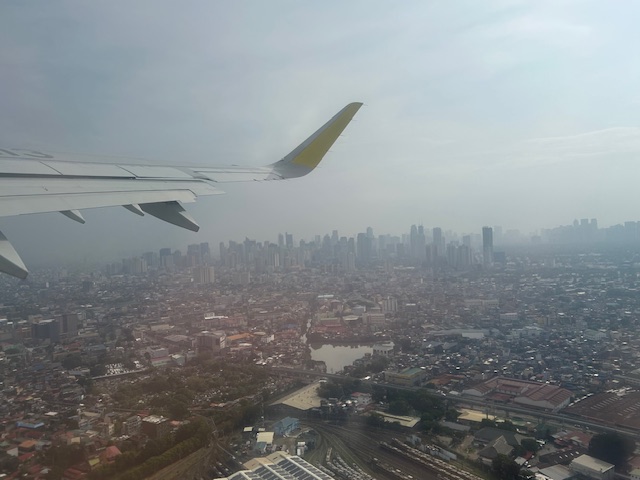
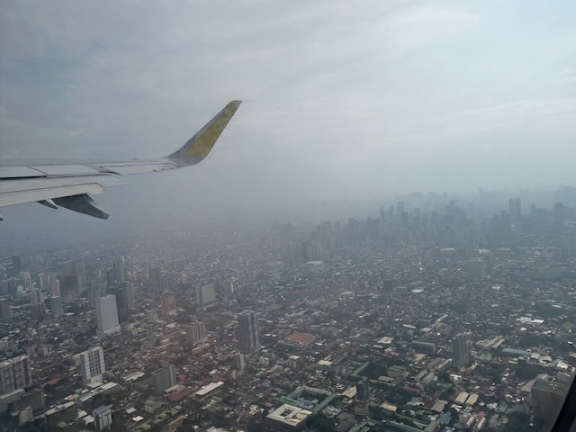
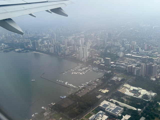
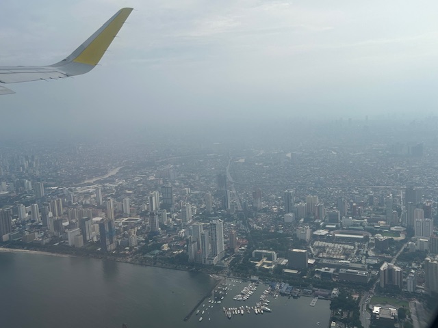
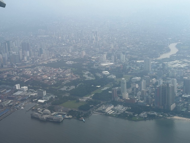
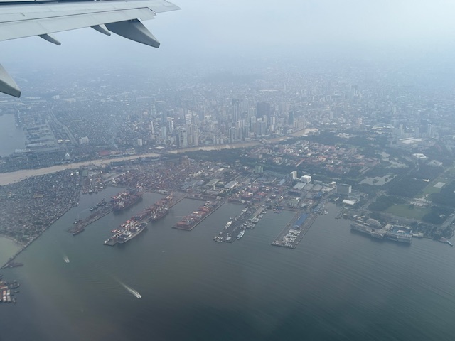
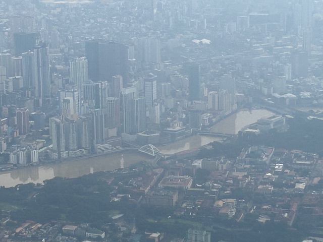
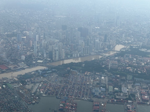
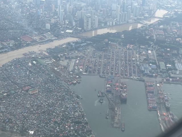
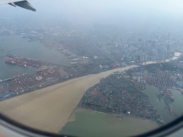
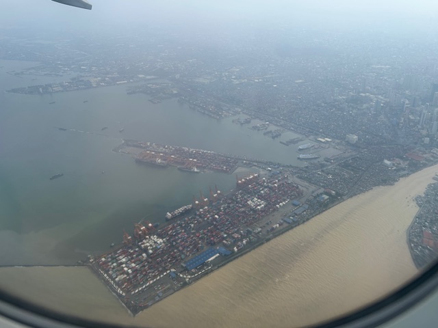
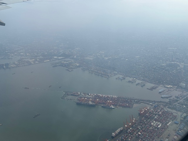
Post Habagat Aerial Photos
We flew to Iloilo just after the Habagat floods that ravaged much of Metro Manila and its surrounding provinces. As our plane took off from Runway 13-31, I figured there was an opportunity to take a few photos of Metro Manila especially as I was seated by the window of the plane.
More aerial photos to be posted here soon!
–
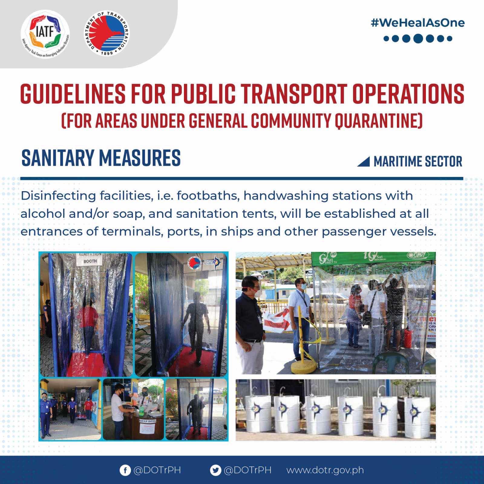
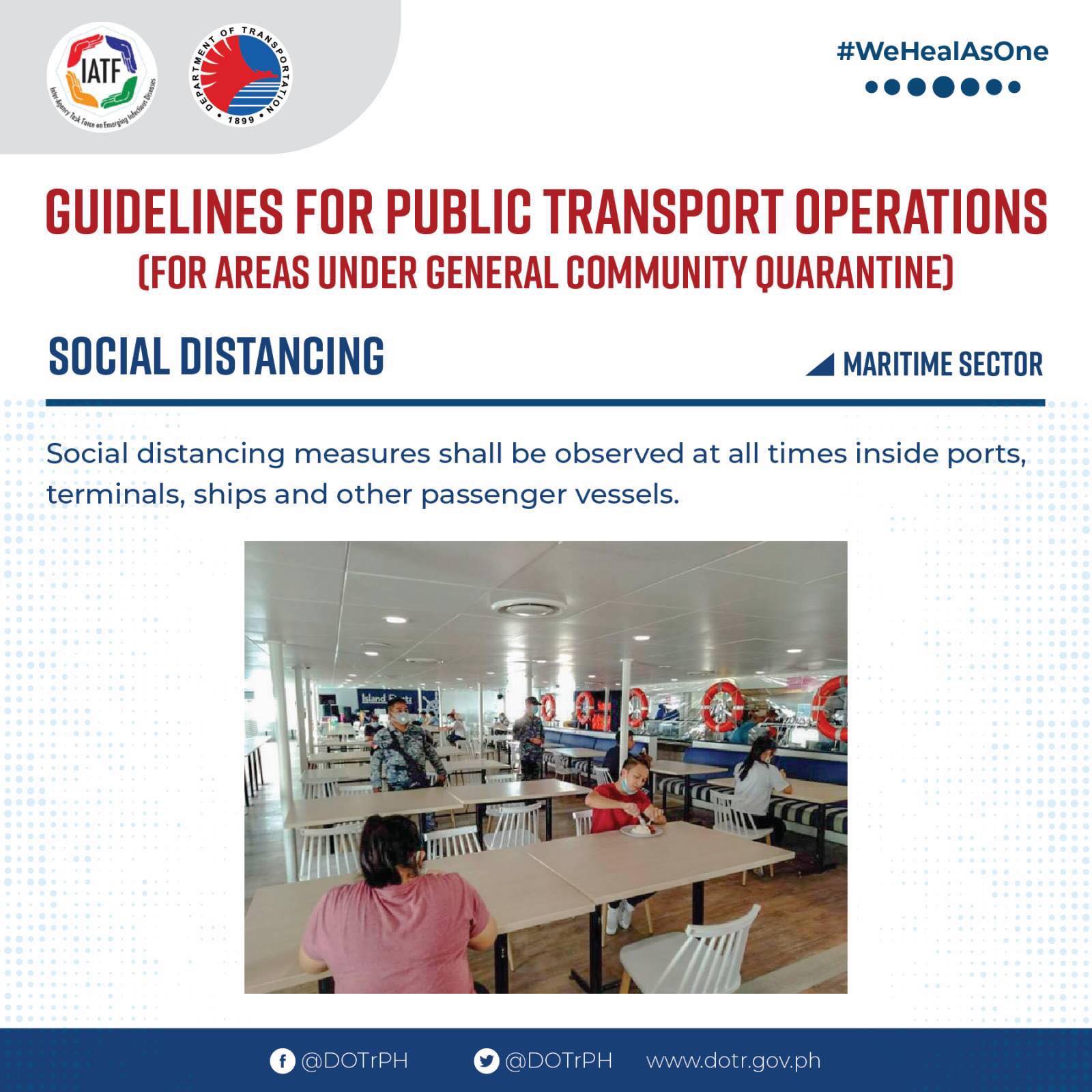
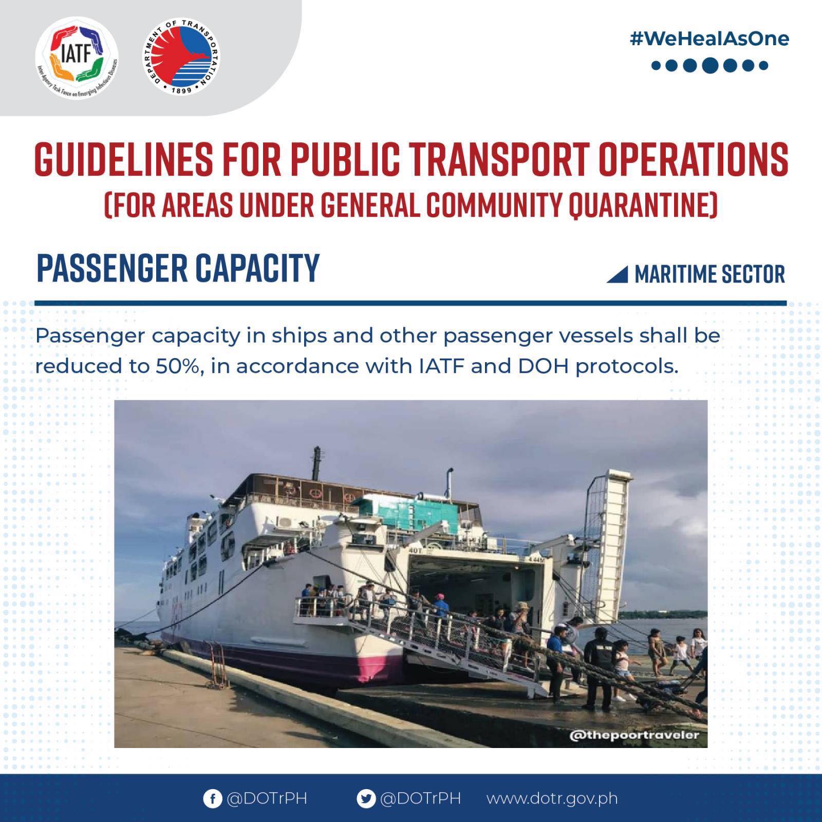
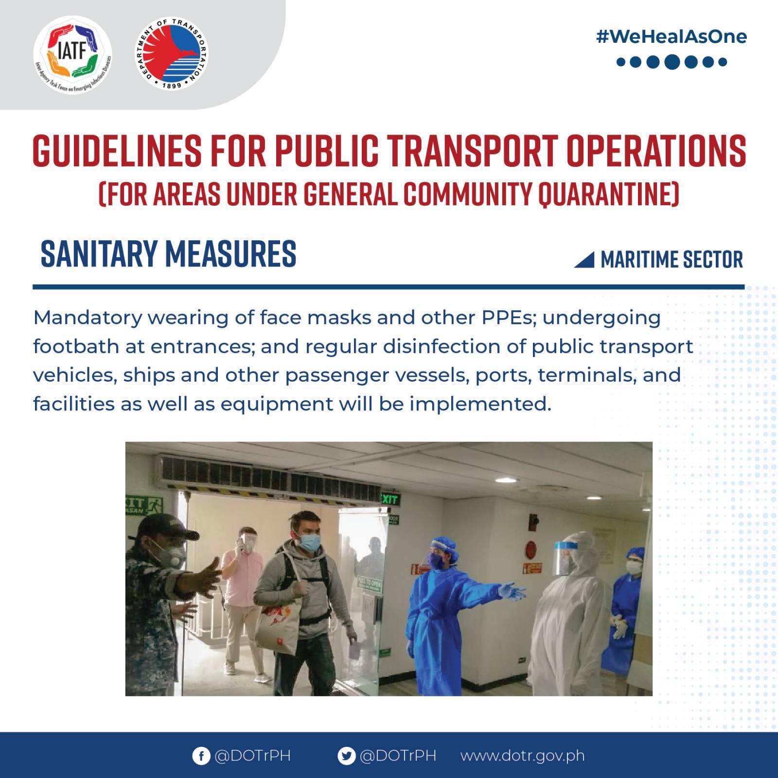
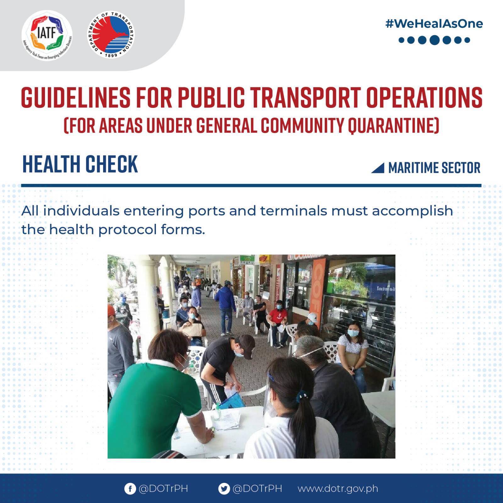
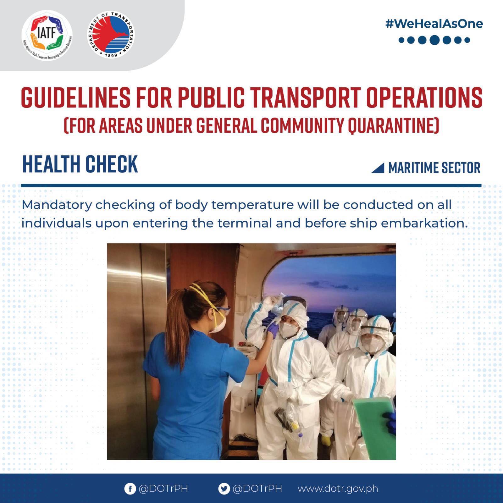
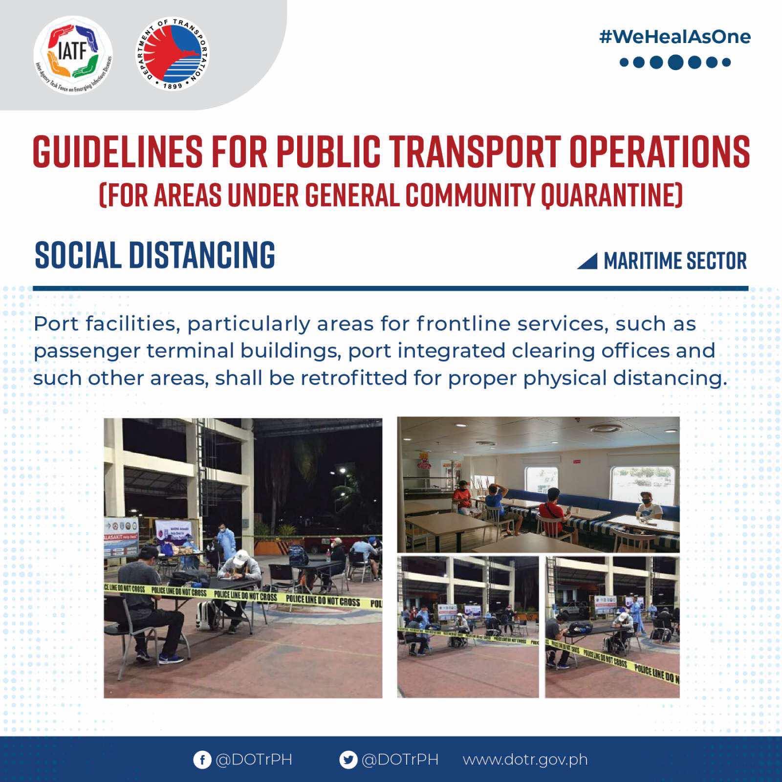
On the DOTr for Public Transport – Maritime Sector
Here’s a continuation of the set of guidelines issued by the Department of Transportation for transport operations for areas that are or will be under the General Community Quarantine (GCQ). Again, I try to refrain from making any critiques or comments, and post this for information and reference.

–
Aerial photo: Zamboanga City’s fish canning and bottling factories
As we approached Zamboanga City’s airport last week, my colleague and I surveyed the landscape trying to identify landmarks. He was quite good at this being a geographer/transport planner. We took a few photos from the plane and one is this shot of the fish port and factories in Barangay Recodo along the national highway.
 Canning and bottling factories lined along the Zamboanga City coast with are mostly fishing vessels anchored off-shore.
There is still an abundance of aquatic resources in the Sulu Sea where these vessels go for fishing. These should be more than enough for domestic as well as typical international demand. Unfortunately, there are alleged foreign trawlers or vessels poaching our resources. These should be seriously looked into by our coast guard and navy.
–
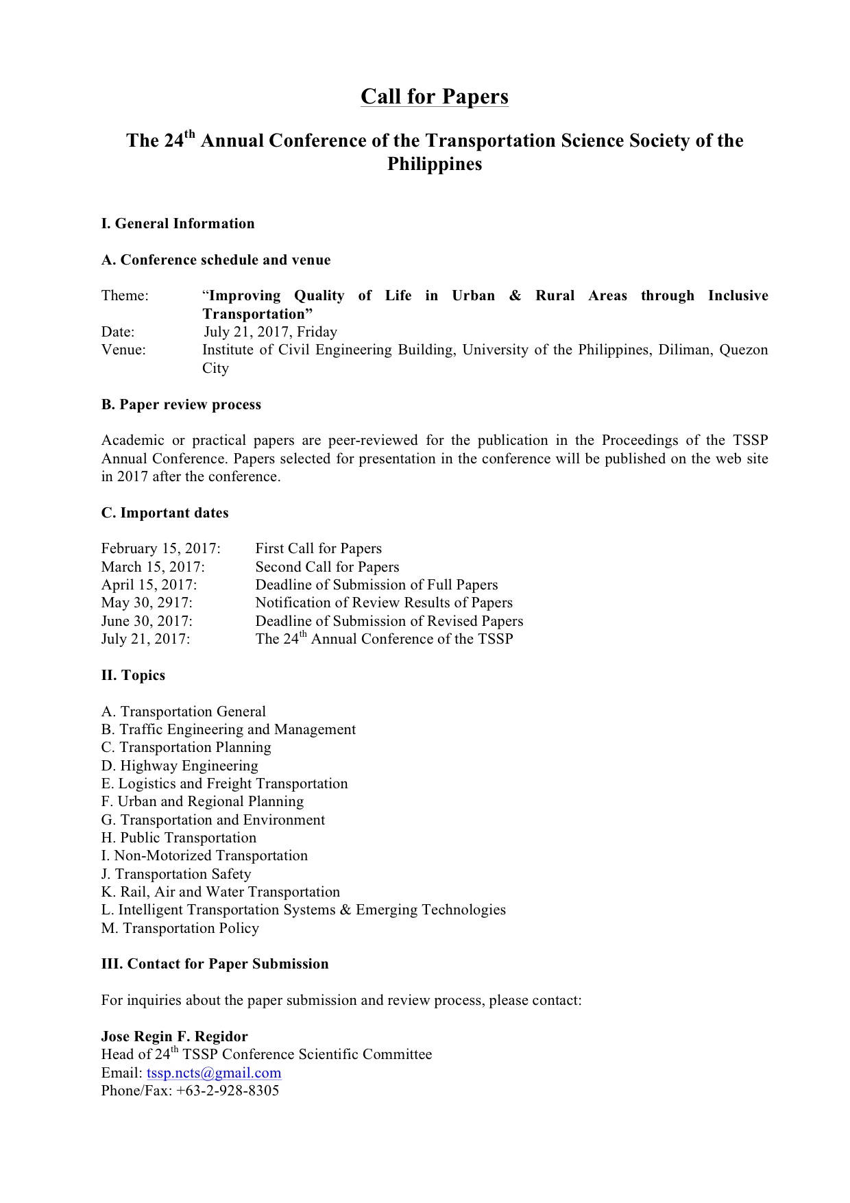
First call for papers for the TSSP 2017 conference
The first call for papers for the 24th Annual Conference of the Transportation Science Society of the Philippines came out last Wednesday, Feb. 15:
–
Local papers presented at the EASTS 2015 conference – De La Salle University
De La Salle University (DLSU) has a strong program in transportation engineering and planning. This program is under its Department of Civil Engineering and led by Dr Alexis Fillone. Following is a list of papers from DLSU:
- Mode Shift Behavior of Bus Passengers to Rail System under Improved Rail Conditions [Alexis Fillone & Germaine Ann Dilay]
- Evaluating Proposed Transportation infrastructure Projects in Metro Manila using the Transport Co-Benefit Analysis [Alexis Fillone]
- Inter-Island Travel Mode Choice Analysis: Western Visayas Region, Philippines [Nicanor Roxas Jr & Alexis Fillone]
- Revisiting Volume-Delay-Functions Used in Transport Studies in Metro Manila [Jiaan Regis Gesalem & Alexis Fillone]
- Characterizing Bus Passenger Demand along Epifanio de los Santos Avenue (EDSA), Metro Manila [Sean Johnlee Ting, Kervin Joshua Lucas & Alexis Fillone]
- Optimized Bus Schedules in Epifanio Delos Santos Avenue (EDSA), Metro Manila Using Fuzzy Rule-Based System [Alexis Fillone, Elmer Dadios & Ramon Intal]
- Opinion Survey about Pedestrianization of Heritage Sites in the City of Iloilo, Philippines [Alexis Fillone & Frederick Sosuan]
- Factors Influencing Footbridge Usage Along Epifanio Delos Santos Avenue (EDSA), Metro Manila [Aaron King, Rigel Cadag, Jireh Despabiladeras, Rei Tumambing & Alexis Fillone]
- A Compact Scheduling and Revenue Estimation Spreadsheet for Bus Operators [Raymund Abad & Alexis Fillone]
- Adaptive Driving Route of Busses along Epifanio de los Santos Avenue (EDSA), Metro Manila, using Fuzzy Logic [Alexis Fillone, Bernard Yasay & Elmer Dadios]
I thought DLSU could have published more papers in this conference. I was actually surprised that all the papers are practically attributed to Dr Fillone considering his co-authors are mostly his students. But then there are only 2 to 3 faculty members who are doing transport research in DLSU and Dr Fillone is the most involved and prolific among them in terms of published research outputs.
–
EASTS 2015 – Cebu City, September 11-13, 2015
The 11th International Conference of the Eastern Asia Society for Transportation Studies (EASTS 2015) will be held in Cebu City this September 11-13, 2015. For information on the conference and program, check out their website here:
You can also download a brochure about EASTS here:
The conference is hosted by the Transportation Science Society of the Philippines (TSSP), which is the local affiliate of the EASTS. More information on the TSSP are found below:
–
Sabang Port – Puerto Princesa
The jump-off point for visitors to the St. Paul Subterranean River (Underground River) is the Sabang Port at the northwest part of Puerto Princesa. Following are photos taken at Sabang including some showing information on transport and procedures for visitors.
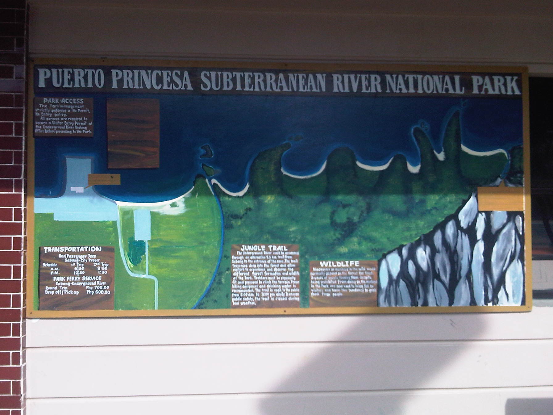 Map of the national park showing some of its features and the transport services to/from the port.
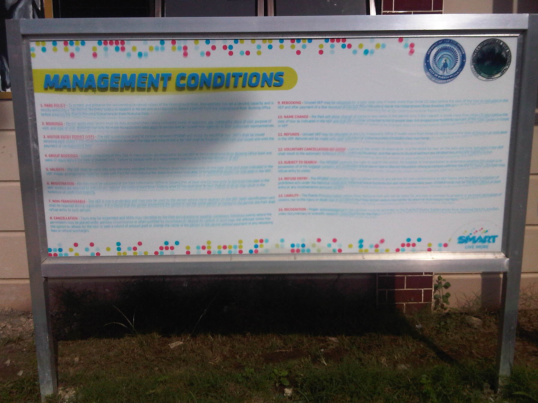 Information on the management of the national park
 Greetings for visitors
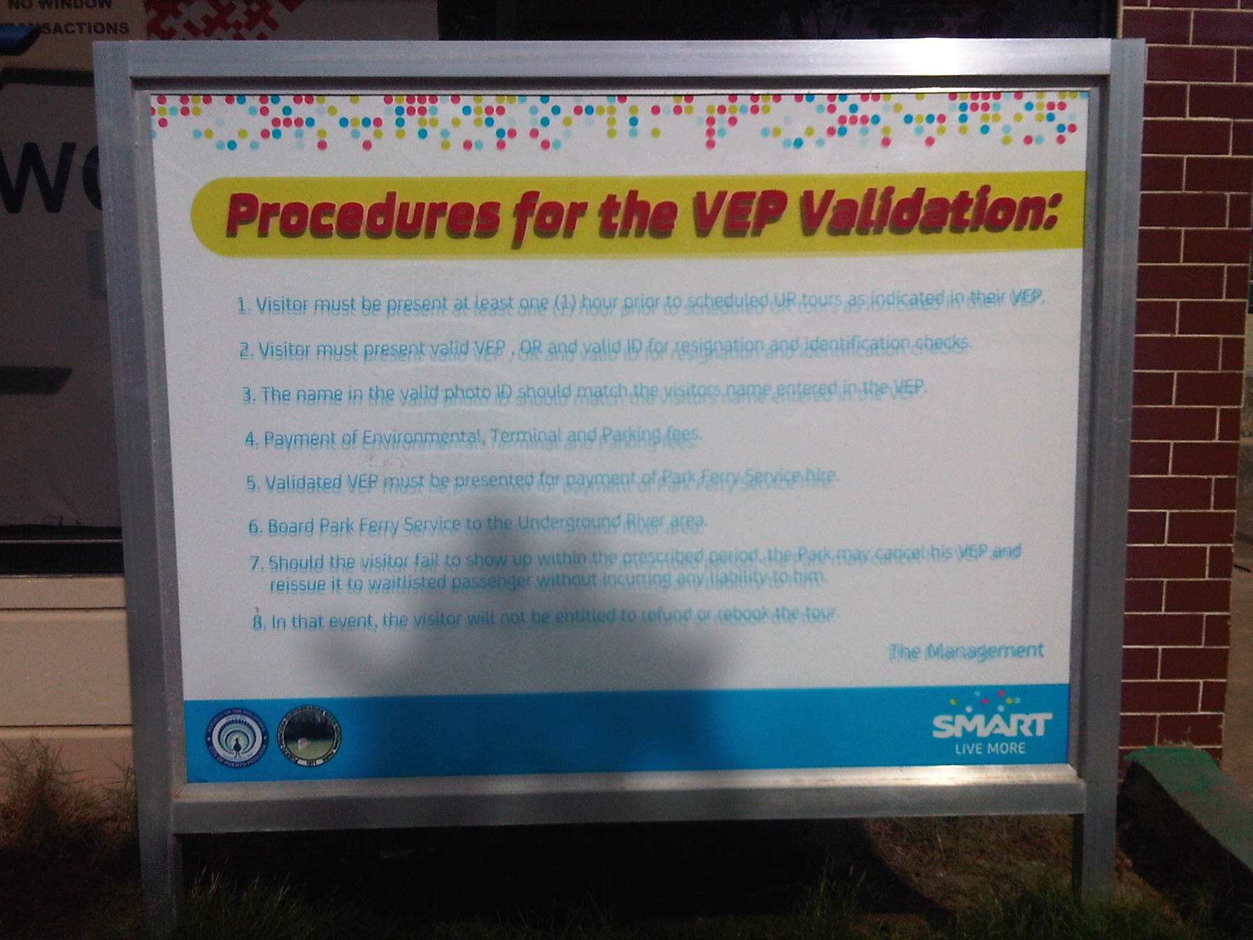 Puerto Princesa limits the number of visitors to the Underground River and there are procedures for visitors and their accredited guides to follow.
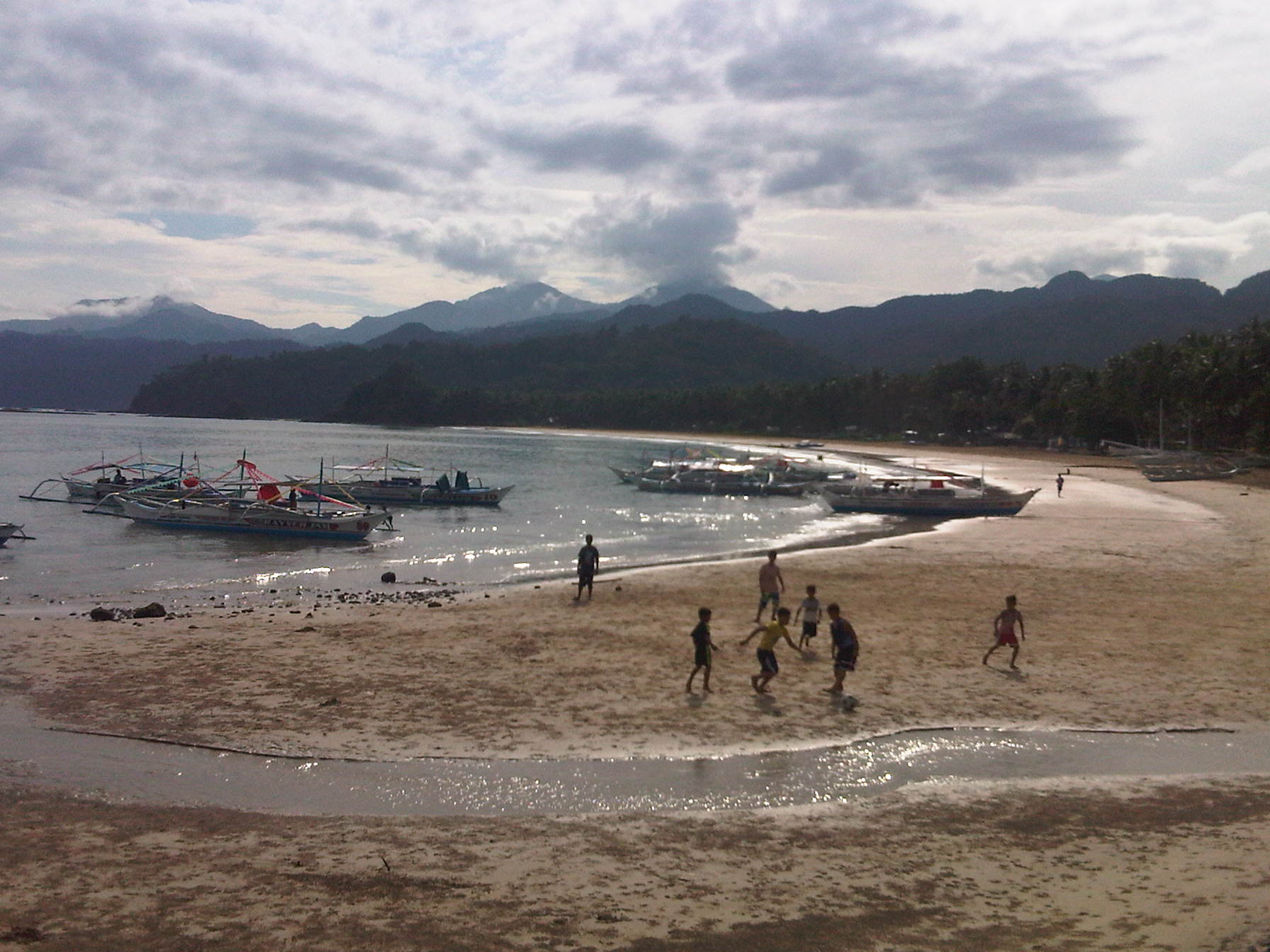 I caught this scene of children playing football on the sands during low-tide.
 While most boats seem to be for ferrying tourists to the Subterranean River, there are also many fishing boats at Sabang.
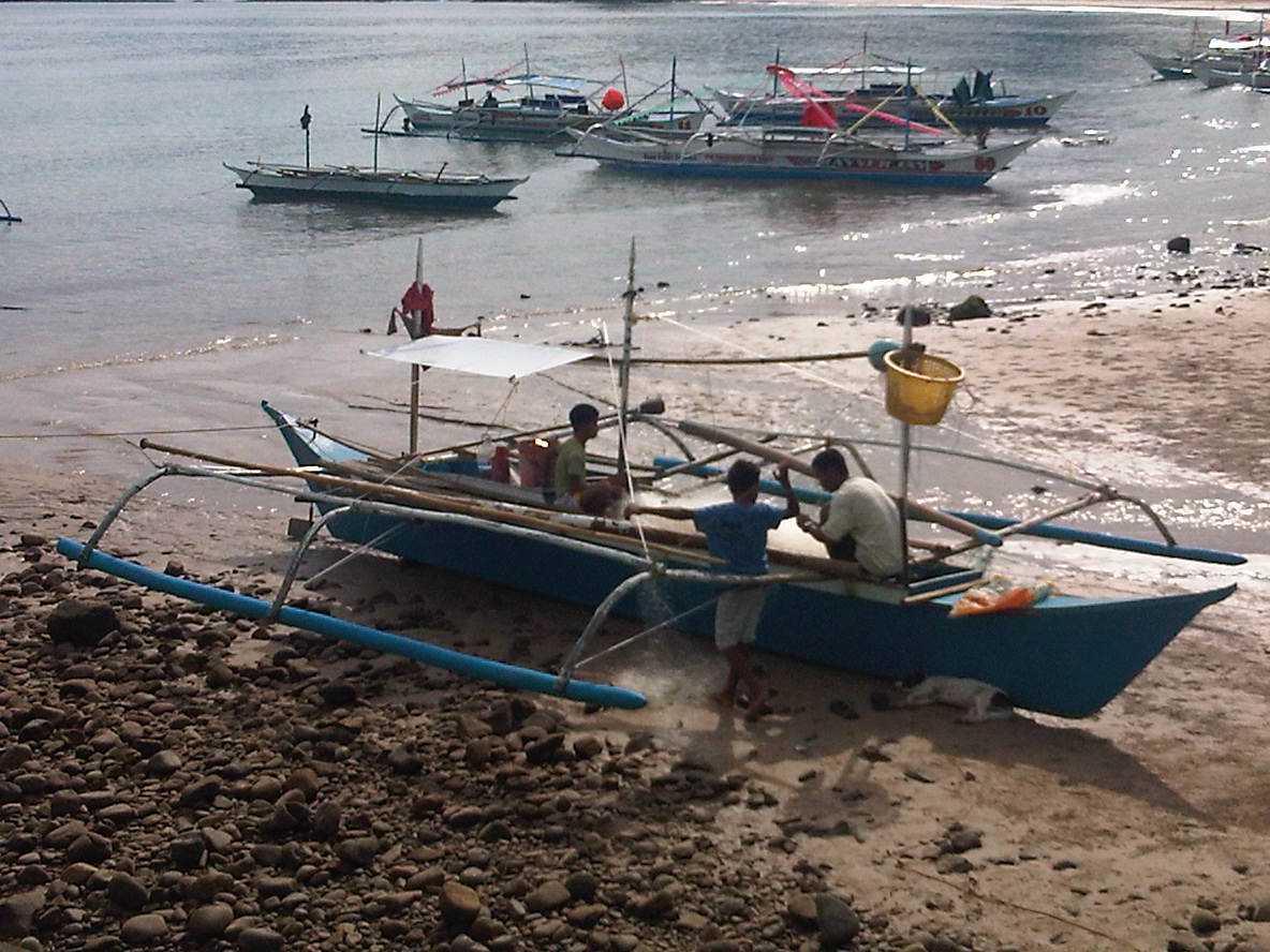 Fishermen fixing up their boat likely before going on a sortie. I could imagine Sabang was like other fishing villages in the Philippines until authorities started promoting attractions like the Underground River. The influx of tourists transformed what was probably a sleepy village into a tourist destination complete with commercial developments like resorts, restaurants and shops.
 Outriggers dot the waters around Sabang Port, their boatmen waiting for their turn to ferry visitors to the Underground River.
 The concrete pier provides a basic but better facility compared to other similar ports around the country. The dispatching of boats is organised and passengers queue in an orderly manner to board the boats assigned to them.
 A boat (left) approaches as another (right) just left, bound for the Underground River.
 Clean restrooms /toilets are a must for tourist destinations. Sayang Port has well-maintained toilets.
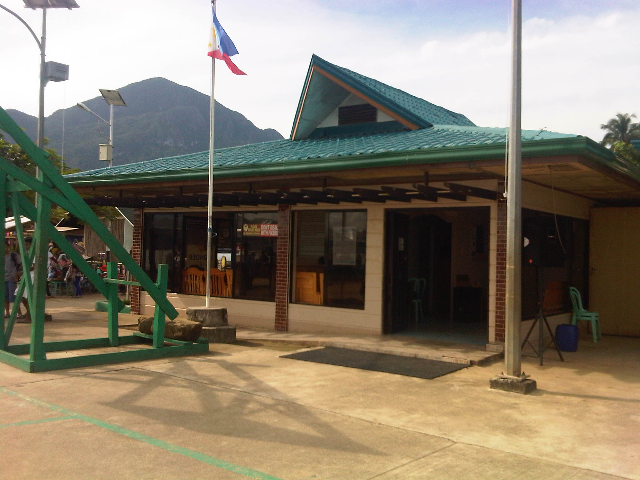 Tourism office at Sabang Port – note the basketball goal post in the photo? The area is also used for other purposes including sports activities. Also noticeable in the photo are street lamps powered by solar energy. We saw some solar-wind power lamps around Puerto Princesa and Sabang’s main road has these for night-time illumination.
 A close-up of the small box showing schedule and cost of transport services to/from Sabang from/to Puerto Princesa city proper. Note that there are only 4 trips per day for public transport (bus or jeepney).
 Boatmen manoeuvre their vessels in the crowded waters of Sabang Port.
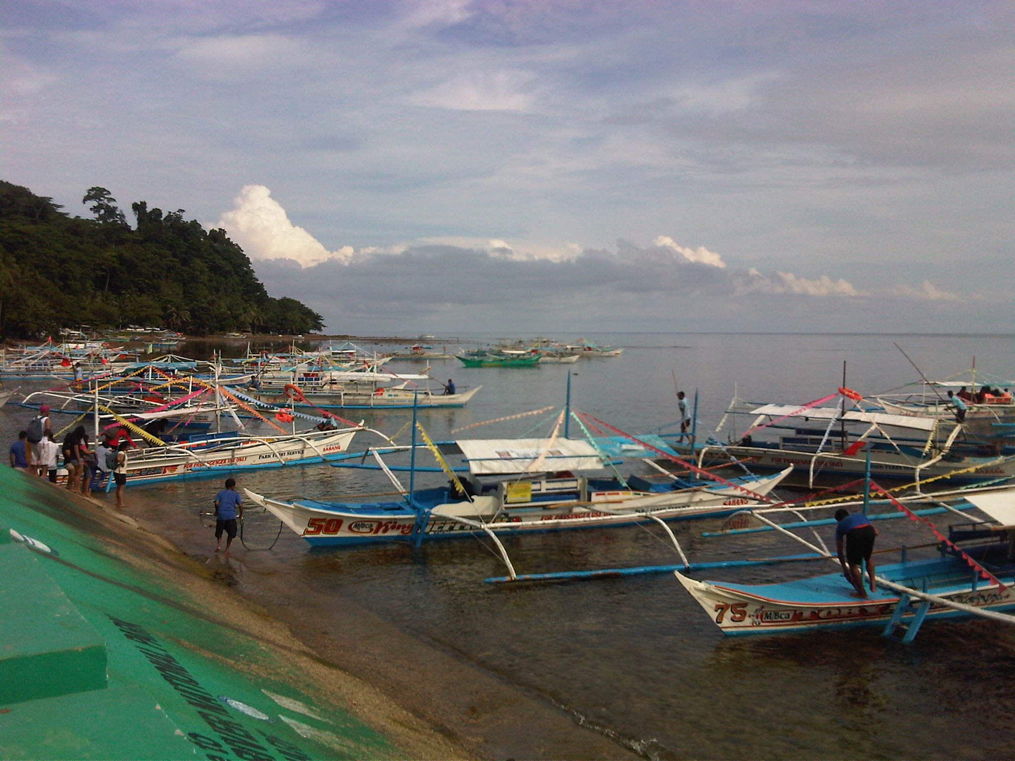 Another photo of boats lined up at the port.
 Portable or collapsible sheds or tents at the port often bear the name of the company sponsoring or providing these for port users. Under one, there was a group facilitating the tour of a group of senior citizens from around Puerto Princesa. We got it from our guide that they are given free rides and visits to the Underground River as part of their benefits as senior citizens.
 Visitors get-off from their boats as other vessels queue to unload their passengers. It takes some skill from boatmen to manoeuvre and make sure they don’t collide with other vessels.
 People get off a boat via a makeshift floating jetty
 Scene of the port and boats from the shop and eatery-lined road along the coast.
Advice to tourists: tip your boatmen generously. They serve as your lifeguards and do their best to maintain the boats and the equipment. They don’t get much from ferrying visitors to and from the Underground River and they do have families to feed. Make this tip your contribution to ensuring sustainable tourism in this heritage site that is also considered one of the top natural wonders of the world.
–
#ReliefPH: Access and needs in many other places
The buzz on the streets and on social media is the focus on Tacloban, Leyte when vast areas and many other towns and provinces have been ravaged by super typhoon Yolanda (Haiyan). This seems unfair to other cities and municipalities considering Yolanda made 6 landfalls at or near peak strength (as a Category 5 typhoon) with winds topping 225 kph and generating destructive storm surges as it hammered through the central Philippines.
If you have Facebook, one provincial government staff has posted a lot of photos describing the situation in the northern towns of Iloilo where the destruction caused by the typhoon is very clear and to many, still unimaginable. These photos along with all others that can be Googled, Yahooed or found via other search engines or news agencies show the extent of the damage brought about by Yolanda.
Some people say that the islands of Cebu, Panay, Negros and Mindoro are fortunate as principal cities in those islands like Cebu City, Iloilo City, Bacolod City, Dumaguete City and Calapan City were relatively undamaged. This is also true, and so the airports and ports in these cities provide direct access to the islands for relief work. Moreover, government agencies and private entities have been able to organize relief activities through these cities and based on various news reports, it looks like a lot of people are already involved in these activities. That goes without saying that more people are still needed to be involved in various capacities for relief, rehabilitation and reconstruction work that are expected to be undertaken over a longer term considering the extent of the damages to towns. But given the circumstances for the said islands, there is no excuse for more rapid aid not being able to reach the affected towns in these provinces. In fact, much more is expected where accessibility is no longer an issue and so faster recovery is possible for Panay, Negros, Cebu and Mindoro. In the cases of Cebu and Bohol, it is important to remember that the provinces already are also still reeling from the impacts of the Magnitude 7.2 earthquake that occurred only a few weeks ago.
On another note…Tacloban Airport is still closed to commercial aircraft but the land routes via RORO or the nautical highways are open to traffic or operational. I think the quickest way to Leyte is via the route from Cebu. There are regular RORO and Supercat services between Cebu City and Ormoc City in Leyte. There are other maritime transport services from Bogo City in northern Cebu but I am not sure those services are back to normal. Then there are also access via the Eastern Nautical Route via the Bicol Region and crossing over to Samar Island (Allen) via Matnog, Sorsogon. Many roads still need to be cleared but the main highway (Pan Philippine Highway) including the San Juanico Bridge that connects the islands of Samar and Leyte.
–
RORO Ferry trip from Batangas to Calapan
[This post has generated a lot of inquiries about fares and schedules for RORO services between Batangas and Mindoro. I would like to clarify that what I wrote about is on one experience we had on a trip about 2 years ago. I am not connected with any of the ferry companies nor am I connected with the port authorities. For more info/details, here as some useful links:
SuperCat: http://www.supercat.com.ph/Fares/fares.asp
Montenegro Lines: http://www.montenegrolines.com.ph/index.php?nav=4
Port of Batangas: http://www.ppa.com.ph/batangas/about.html
Port of Calapan: http://www.ppa.com.ph/Calapan/cal_about.htm
Safe trips!]
—
Following is the original post:
Due to rough seas, there were no SuperCat trips between Batangas and Mindoro when we arrived at Batangas Port one Thursday morning. It seemed that there was only one fast ferry under the banner of SuperCat that plies the Batangas-Calapan route and it was on hold in Calapan due to rough waters. Later in the day though I would theorize that there might not have been enough passengers that morning between the cities and a decision had to be made not to make the trip, with the convenient and irrefutable reason of rough seas.
 RORO Ferry ticket (left) and passenger terminal fee ticket
 A view of two RORO ferries docked at the Batangas Port. One was operated by Montenegro Lines’ Marina Ferries and the other by Starlight Ferries.
 Passengers boarding the ferry Reina Hosanna. Some vehicles, mostly trucks were already loaded on the ferry. Others would have to wait until passengers have boarded the vessel.
 A view inside the ferry where vehicle and freight are positioned and secured for the voyage. People form a line before the narrow stairway to the passenger level.
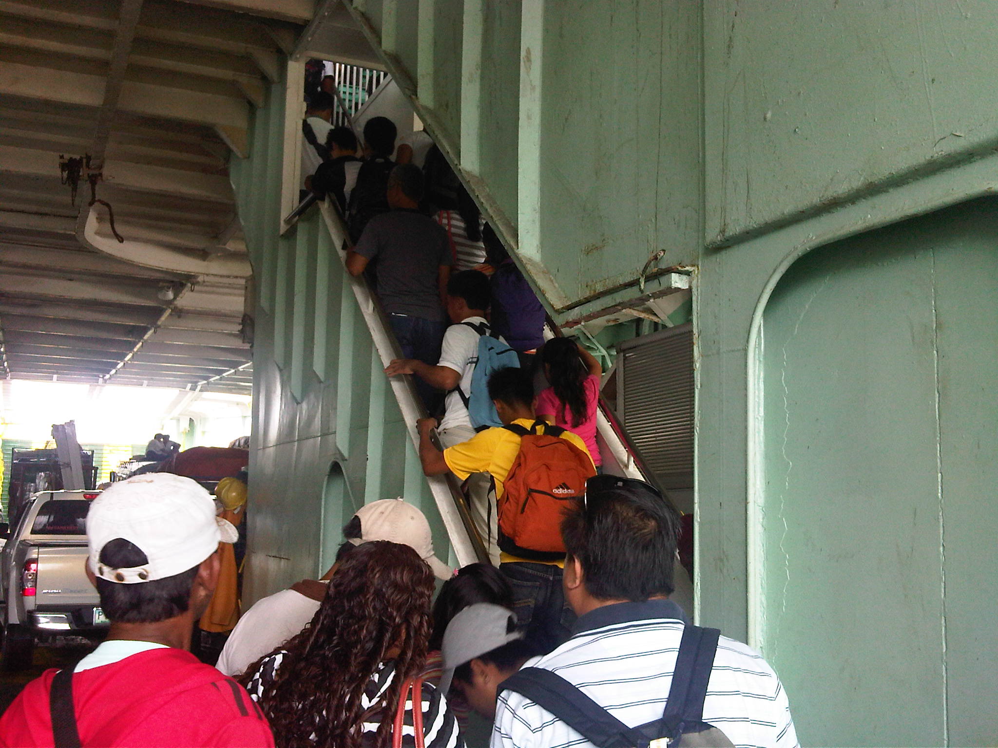 Passengers climbing the narrow stairway to the passenger deck of the Reina Hosanna.
 A view of the Batangas Port from the upper (view) deck of the ferry right above the passenger deck. Trucks can be seen boarding (rolling on) the ferry. The orange things are lifeboats lined along the rear of the passenger deck.
 A provincial bus arrives to board another RORO ferry, the Starlight Nautica, which was scheduled to leave an hour after our scheduled departure. There are many bus companies plying the western nautical highway route , which can take the traveler to Caticlan, the jump off point for Boracay Island.
 Reina Hosanna crewmen raise anchor.
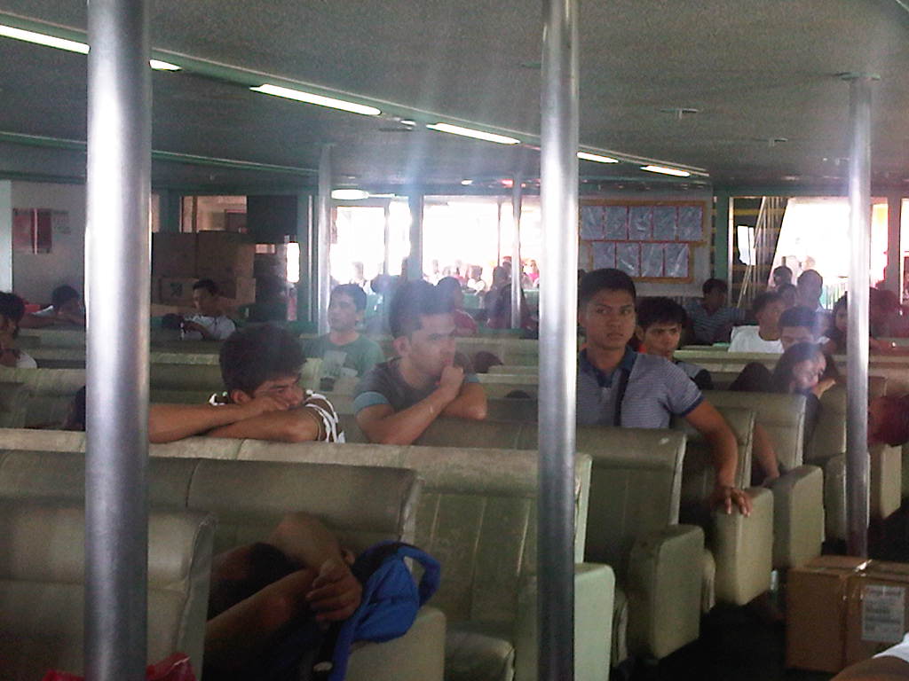 A view inside the passenger deck – seats were cushioned but mostly dilapidated and obviously requiring re-upholstery. The cabin seemed to be originally air-conditioned and we were lucky that the weather was fine and not so hot that day. Some passengers went to the upper deck to get some air.
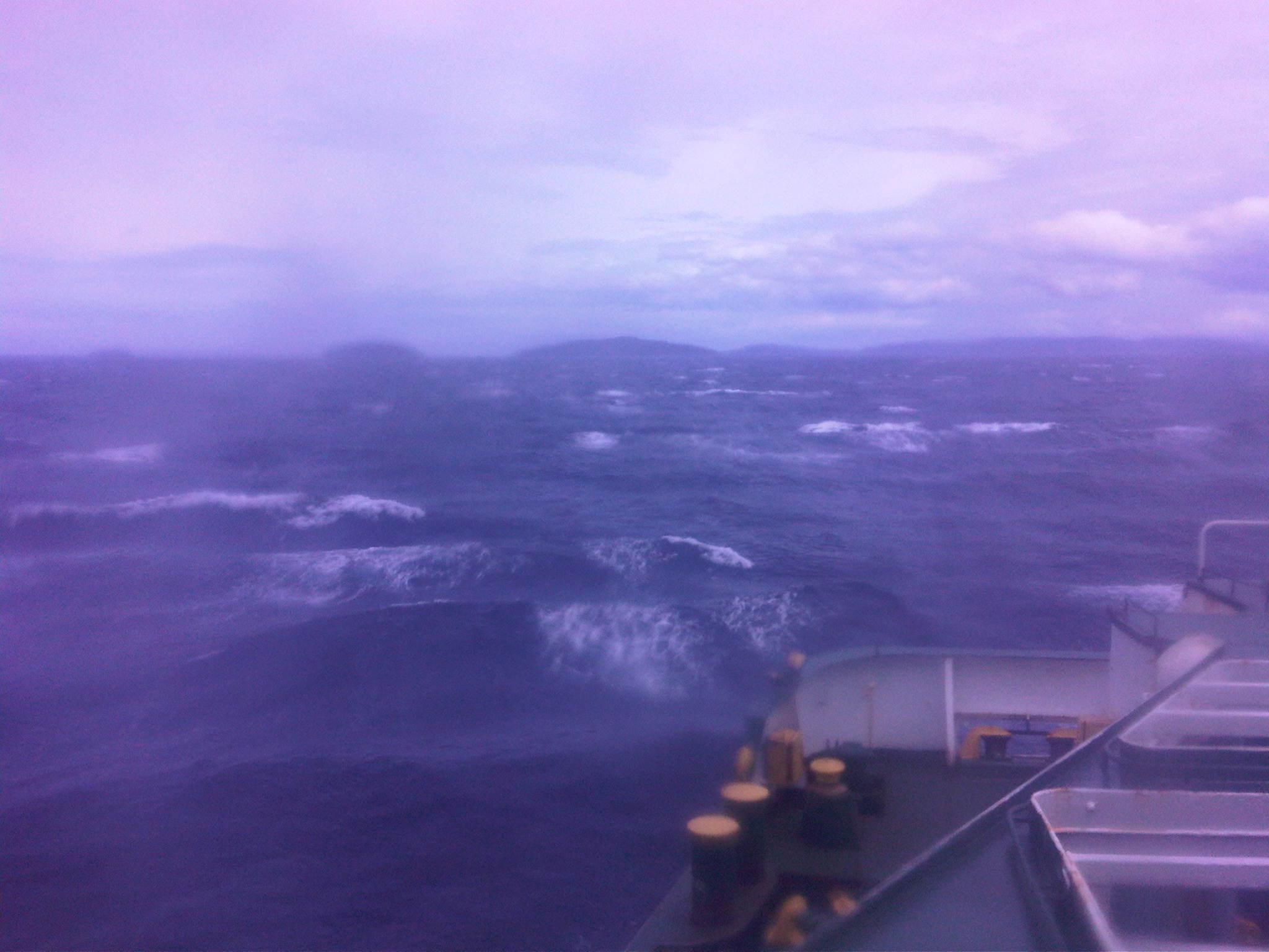 Rough seas along the Verde Island passage to Calapan. We actually saw two fast craft going the opposite direction during our almost 3-hour voyage to Mindoro. One was a SuperCat and another was a FastCat, and they were traveling despite the same rough waters shown in the photo!
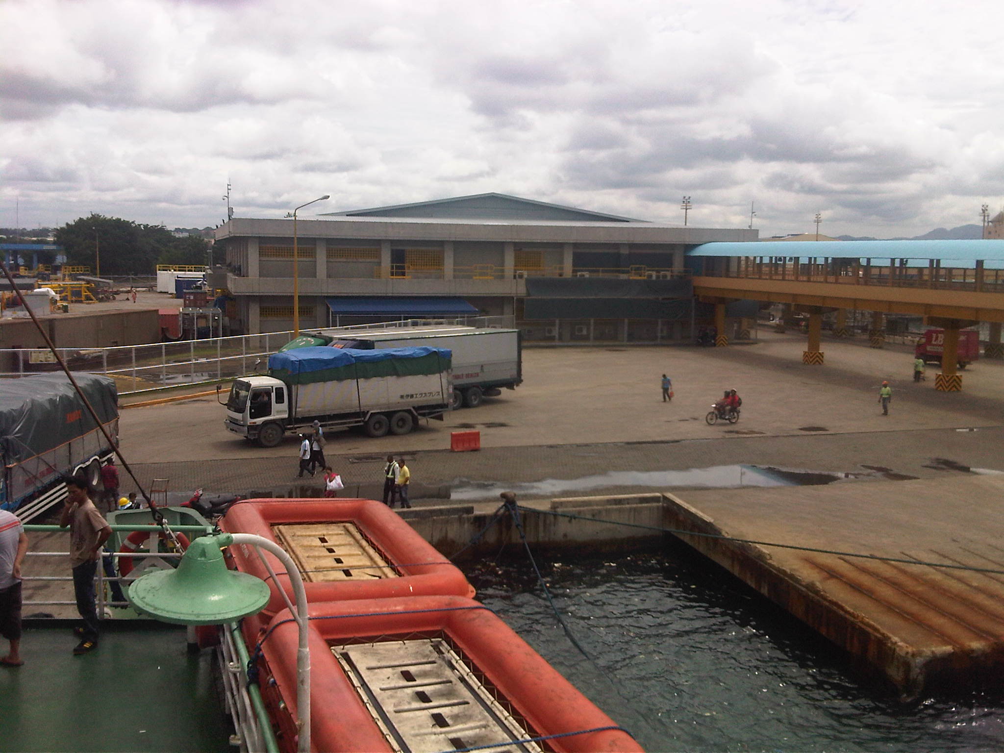
 Another ferry preparing to leave Calapan Port.
 Crew throwing a line to the port as our ferry docked at Calapan.
 Passengers disembarking from the ferry.
 Vans waiting for passengers bound for various destinations in Mindoro including those in Mindoro Occidental on the other side of the island.
It was my first ferry ride in a long time. The last one was a fast ferry trip using the SuperCat service from Cebu to Tagbilaran, Bohol. That was in the afternoon and was quite a rough ride, too. I think shipping lines should not balk on the safety and comfort of passengers. People would be willing to pay a higher fare if the vessels are in better condition and facilities such as seats are well-maintained. I can only imagine the traveling conditions during the peak periods when a lot of people would take these RORO ferries as they are usually the cheaper and practical option between islands. –
Fast ferries in the Philippines
The Philippines is an archipelago, meaning it is comprised of islands, some 7,107 of them. As it is impractical (read: too expensive) to connect the larger islands by bridges or tunnels, the connections would have to be made via either maritime or air transport. In previous postings, I have already written about some of the more modern airports in the country like the Bacolod/Silay, Iloilo and Davao airports. What I have not written about in this blog is something in maritime transport.
To get a feel of the current state of commercial maritime inter-island transport (i.e., not including those using motorized or human-powered boats or bancas), I thought it most appropriate to feature fast ferry/fast craft services that are quite popular in the Visayas and Mindanao. I will write on roll-on, roll-off (RORO) services and the nautical highway in the future.
There have been much progress in the upgrading of maritime transport services between islands in the Visayas and Mindanao. This was made possible with the introduction in the 1990’s of fast craft or fast ferries popularly called Supercat with the cat in reference to the catamaran-type vessels plying routes like Bacolod-Iloilo, Cebu-Tagbilaran and Cebu-Dumaguete. These fast crafts effectively cut down travel times by half with the Bacolod-Iloilo run trimmed down from 2-2.5 hours to 1 hour. Following are a few photos of fast crafts and terminal facilities in Cebu City.
 Typical fast ferry docked at the Cebu terminal of the Aboitiz Co.
 Twin-hulled SuperCat approaching the Cebu port
 Inside the fast ferry terminal, there are plenty of space and seats for waiting passengers. There are also concessionaires selling food, drinks and souvenir items.
 Floating piers serve as the port’s extensions to accommodate fast craft operations
 Passengers boarding the fast craft via bridge connecting the terminal to the floating piers
 On-board the SuperCat, seats appear like those for long-distance buses complete with head rests for the comfort of passengers. The vessel cabin is fully air-conditioned.
 Another view of the seats inside the vessel show comfortable seating for passengers as well as wide windows for those wanting to have a view of the islands. There is also a snack bar inside the vessel serving food and drinks to hungry or thirsty passengers.
Fast ferry/fast craft services are quite popular in the Visayas and Mindanao and provide a less expensive option to air travel. These complement the RORO services that are more about long-distance travels between cities in different parts of the Philippines, like for example Manila to Iloilo. Such services offered by fast craft are essential for both commerce and tourism and should be encouraged for further development or upgrading, especially in terms of terminal facilities that are still wanting or deficient in many ports in the Philippines.
–
