
Home » Traffic Congestion (Page 4)
Category Archives: Traffic Congestion
Technical sessions at the TSSP 2024 Conference
I am sharing here the latest draft of the technical sessions for the 30th Annual Conference of the Transportation Science Society of the Philippines (TSSP). The conference will be held in Iloilo City this coming September 13, 2024.
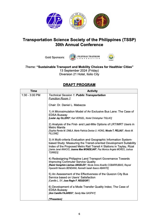
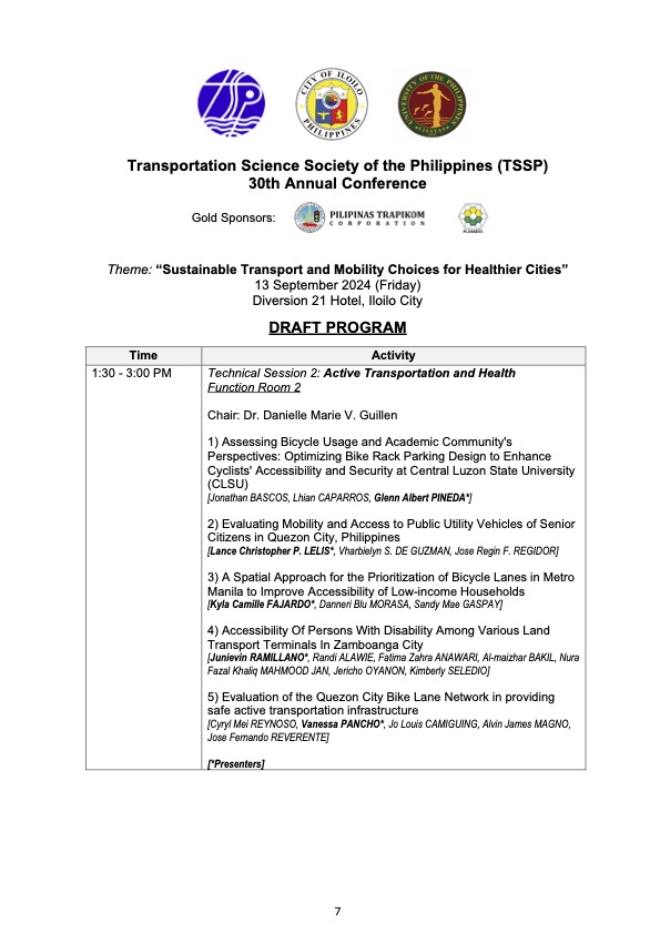
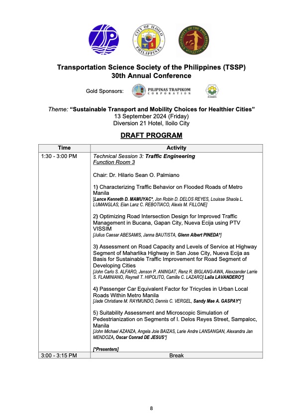
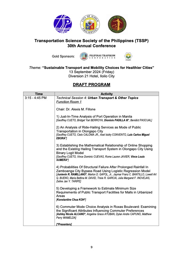
I will share the draft program for the morning plenary session in the next post.
–
On the idea of congestion pricing
I purposely titled this post to include the word ‘idea’ as congestion pricing is still very much like that in the Philippines. It is a reality in some part of the world particularly in Singapore where its Electronic Road Pricing (ERP) has evolved and improved over the years. Its success though seems to be an exceptional case that has not been replicated elsewhere where conditions are not exactly like the city state’s.
Here is an article that recently came out from The Washington Post about the New York Governor’s decision to backtrack on the proposed congestion pricing initiative in New York City:
McArdle, M. (June 12, 2024) “People hate traffic. They also hate this great idea to clear it,” The Washington Post, https://www.washingtonpost.com/opinions/2024/06/12/congestion-pricing-great-idea-people-hate/ [Last accessed: 6/14/2024]
To quote from the article:
“Roads are a scarce good; you can fit only so many cars on a road at one time, and fewer if you would like those cars to go somewhere. When roads are “free,” we are forced to fall back on a more costly and inefficient strategy: sitting in traffic. This wastes valuable human time and inflicts noise and pollution on everyone nearby. Far better to charge a modest price that inspires some drivers to carpool and others to take public transit or shop nearer to home, until supply and demand are balanced and traffic flows easily…
In political disputes, a discrete group facing highly concentrated costs often defeats a larger public interest that conveys a small individual benefit to everybody — such as being able to move around the city faster when you really need to. This is particularly true in the American system, which is designed to empower angry minorities. And it’s especially true when they’re abetted by status quo bias and a sympathetic majority, as in this case.
Complain all you want about selfish suburban drivers or the Metropolitan Transit Authority’s bloated cost structure or Hochul’s cowardice; the biggest obstacle to congestion pricing is that almost two-thirds of New York City residents have told pollsters they oppose it — in a city where less than half of all households even own a car. A more technocratic, less democratically responsive government might have been able to ram it through, and perhaps in time everyone would have come to like it. But in fractious America, with all its political veto points, congestion pricing is doomed by the reality that people hate slapping prices on things — especially if they have to pay them.”
There is a congestion pricing proposal in Baguio City and we don’t know yet how this will go. I don’t have the details yet except that a private company whose core business is tollways is involved. Will this be a model or a proof of concept? Or will it just go the way of a typical tollway where users are those who are willing to pay and which would eventually congest if most of the current users pay and use it anyway? Will the funds generated be used to develop a more efficient transport system for Baguio, eventually leading and contributing to less congested streets? That would also mean eventually less revenues from the congestion pricing scheme and probably lead to it being unnecessary.
–
Another roadblock for active transport?
The Metro Manila Development Authority (MMDA) recently released what they claim to be their counts of bicycle traffic along major roads in Metro Manila from 2020 to 2023.
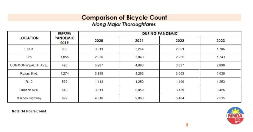
These are supposed to be official data as it is issued by the government agency in-charge of traffic management for Metro Manila roads (aside from its other functions and roles). What are not stated, and are actually very important details, are the locations of the counts and when the counts were conducted. The Traffic Engineering Center (TEC) that was under the DPWH and currently with the MMDA used to publish traffic volume maps for major roads in Metro Manila. So along EDSA, for example, the volume per section are shown on the map. The same for other major roads like Commonwealth, Quezon Avenue and SLEX. The thicker lines mean higher volumes along those sections, and vice versa. However, they did not consciously count bicycles (only motor vehicles) and perhaps MMDA only started counting during the pandemic (i.e., 2020). So there is no one value to represent a road. And counts vary over time of day, day of the week and even throughout the year (i.e., monthly variations).
There were many reactions to the MMDA’s posting of the data and most were critical and even derided the agency for what to them appeared to be inaccurate data. The problem is that it seems there are no other counts that can validate and perhaps refute the MMDA data. Previous bike counts were not conducted according to how the MMDA and DPWH count vehicles. That is, counts are typically done over a 14 or 16-hour period and ideally on several days in a year. Expansion and conversion factors are applied based on established stations along major roads that are supposed to have more frequent if not continuous counts. This methodology is how Annual Average Daily Traffic (AADT) is computed. Call it car-centric if you like but the methodology is very much applicable to bicycles as well. Peak hour counts for bikes are not enough and the peak hour factor for motor vehicles does not apply to bicycles (if this is to be used to expand/convert peak volumes to daily values). In fact, if you go into the math, there should be a peak hour factor for each type of vehicle considering each vehicle’s volume will vary differently over time. So yes, the solution here is to conduct bicycle counts according to how MMDA or DPWH counts vehicles and these should be done along several stations along major roads (e.g., those in the table above) to validate the MMDA counts.
More on this topic in the next post!
–
A widened Col. Bonny Serrano Avenue and opportunities for complete streets
Col. Bonny Serrano Avenue is one of the major roads directly connecting EDSA (C-4) and C.P. Garcia Avenue (C-5). The last time I used the road was before the pandemic. So it came as a surprise to pass by last weekend and see the avenue had been widened. I guess that pretty much “solved” the traffic along this usually busy thoroughfare that is part of jeepney routes to Cubao (via Murphy – referring to Camp Aguinaldo, which was formerly Camp Murphy). The avenue was renamed after a Korean War Hero (my uncle fought under him with the 10th Battalion Combat Team in the Korean War in the 1950s). It was called Santolan Road before.
 What used to be a 4-lane road is now an 8-lane road
The area used for road widening was carved out of Camp Aguinaldo. The headquarters of the Armed Forces of the Philippines (AFP) gave up quite a lot of square meters for this project and you can see from the photo the now very wide avenue. I thought perhaps they could have placed a median island where they could have also planted some trees (note how exposed to the sun the area is). They also could have designed protected bike lanes along either side of the road. These could have connected the EDSA and C5 bike lanes. And, of course, they should have also improved the pedestrian sidewalks. You can see how narrow the sidewalks are and how electric and light posts block pedestrians using the sidewalks. There were opportunities here for the application of complete streets and its not too late to do just that.
I assume there are many men in uniform who use bicycles for their commutes and recreation. Camp Crame is just across EDSA from Camp Aguinaldo and Bonny Serrano Avenue also passes along the headquarters of the Philippine National Police (PNP). Down the road towards Marikina City in Libis is another camp, Camp Atienza, which is home to the 51st Engineering Brigade of the Philippine Army. I mention these camps as I know many there regularly use Bonny Serrano for commuting and many use bicycles. A cousin-in-law (my wife’s first cousin) who is an army officer bikes a lot from Camp Atienza and Camp Aguinaldo and tells me there are many enlisted men who bike to work.
–
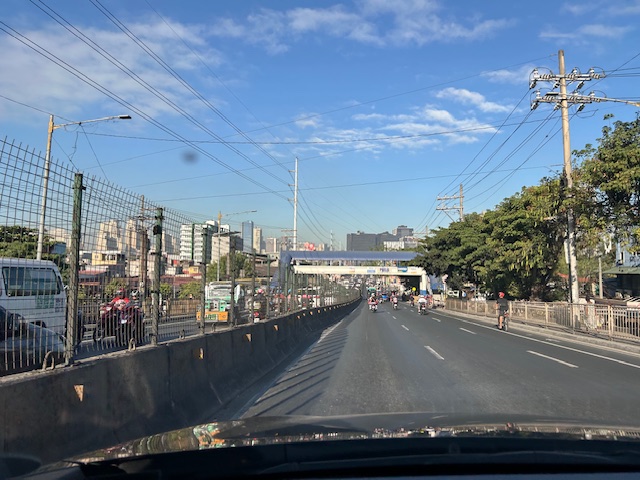
Counterflow irony along Ortigas Avenue Extension, Pasig City
One Friday, I traveled to Ortigas Center from Antipolo via the most direct route using Ortigas Avenue Extension. I was not surprised by the counterflow scheme being implemented starting from De Castro all the way to Rosario Bridge. I was also not surprised that the more congested lane was the counterflow lane. I thought everyone expected the main traffic lanes to be congested as PUVs like jeepneys, buses and vans usually create bottlenecks as they block traffic while passengers board/alight along that section of Ortigas Avenue Extension. Here is what you might encounter in terms of traffic if you opt to stay along the westbound traffic lanes:
 Traffic before the Manggahan floodway bridge at what was generally called Mariwasa. The Filinvest residential development on the left used to be the Mariwasa tiles plant.
 Traffic after the crossing the bridge. Note the pedestrian overpass in the photo.
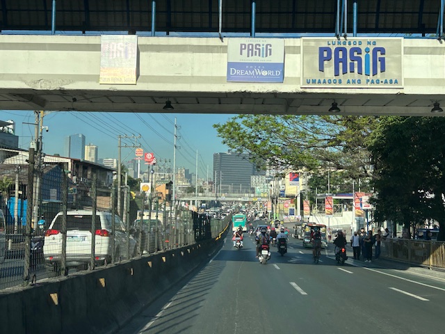 Meters after and near the overpass, you can already see the build-up in the Rosario area
 The Rosario bridge area is usually congested not just because of the PUV operations but also because there is the junction of Ortigas Avenue Extension and Amang Rodriguez Avenue, which is another major thoroughfare connecting this area to other parts of Pasig, Quezon City and Marikina City.
I will post about the counterflow scheme in Bangkok in the next post.
–
Zamboanga’s first flyover
We passed by the construction site of Zamboanga City’s first flyover at the intersection of the Pan Philippine Highway (AH 26) and Veteran’s Avenue. I recall there was a lot of pressure from DPWH for the city to approve its construction. The previous mayor didn’t want to approve the project because the perception was that it was not required and there were other options to consider before a flyover was to be constructed. However, many people including the then congressman and now mayor probably thought the flyover would be the solution to the congestion experienced at the intersection. Add to that the perception that the flyover is also somewhat a symbol of progress.


We won’t know until its completion and the ‘normalization’ of traffic in the area to determine whether the flyover has ‘solved’ traffic congestion in the area. The problem with this approach to ‘solving traffic’ is that it is usually a short-lived alleviation of a symptom of the real problem, which is transportation. Zamboanga City has deferred rationalization of public transport routed despite analysis and plans pointing to a streamlined and optimized transportation system if this was pursued. The City commissioned a Transportation and Traffic Management Plan Study in the previous administration but the plan and its recommendations have been shelved, another example of such being casualties of a change in administration of an LGU.
–
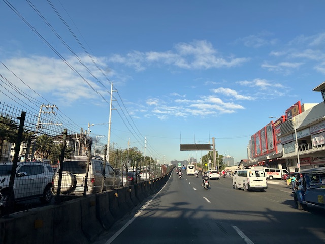
Maulan, ma-traffic
I just wanted to share this photo taken a couple of weeks ago when there were a few rainy days. These were not light rains but downpours that caused some flash flooding on streets along my commuting route. The flash floods plus vehicles generally slowing down due to the rains lead to traffic congestion. I thought this was what brought about the saying “maulan, ma-traffic” that translates into “it’s rainy so expect traffic congestion”.
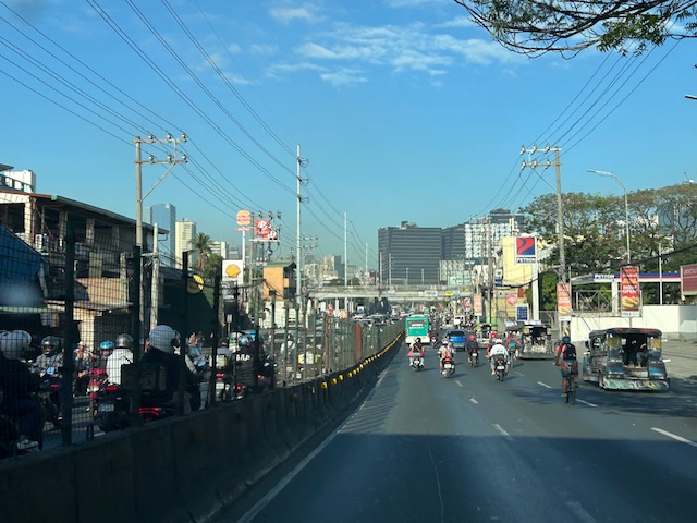
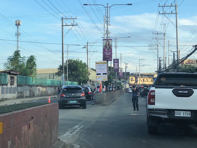
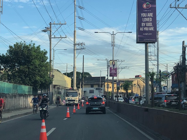
 Vehicles caught up in a traffic jam along Ortigas Avenue Extension
–
Counterflow lane to Cainta Junction along Felix Avenue
Counterflow traffic schemes seem to be in these days. Cainta used the scheme temporarily while one lane of Felix Avenue was blocked due to the maintenance work being conducted by Manila Water. Following are photos showing the traffic advisory and photos during the counterflow.
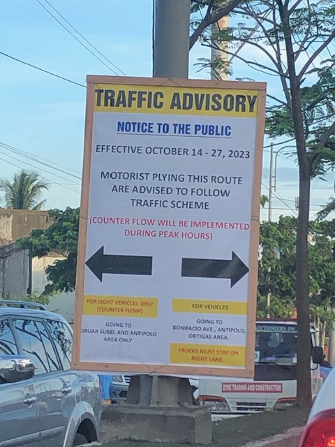 Traffic advisory showing the period when the counterflow traffic scheme was implemented.
 There was a median opening across from a factory’s main gate that allowed vehicles to counterflow.
 The counterflow lane allowed vehicles to bypass the utilities maintenance works being performed by Manila Water’s contractor that blocked the median side lane of Felix Avenue.
 Approach to Cainta Junction
 The counterflow ends at Cainta Junction where left turning vehicles are positioned correctly for the movement. Through traffic were expected to occupy the other/normal approach lanes.
As the Manila Water concluded its maintenance work, the counterflow scheme was already lifted and traffic is back to normal.
–
On Undas traffic 2023
The past two years, I have not written about the traffic situation or conditions during Undas or the holidays corresponding to All Saints and All Souls Days (November 1 and 2). There wasn’t much to write about really. The usual traffic congestion would be along roads near cemeteries and memorial parks. Marikina City’s Barangka area and Bonifacio Avenue near Loyola Memorial are usually congested due to the city’s public cemetery and the memorial park combining for significant traffic generation during Undas. The days leading to Undas find people traveling, usually back to their hometowns but these days many go out for vacations instead. And so the roads near the airports, seaports and bus terminals are also congested. Tollways and national roads (especially the main corridors) can also be congested with the exodus of people from Metro Manila to the provinces in Luzon Island. I assume something similar occurs for other major cities as well.
Many people I know seem to be vacationing this week as they took advantage of the October 30 Barangay elections and the declaration of November 2 as a holiday to take the week off. Many probably took leaves for the two days that were not declared as holidays – October 31 (Tuesday) and November 3 (Friday). Many if not most schools I know declared a break for the week. It is, after all, an opportunity for students, teachers and school staff to take a breather. At UP though, this week came shortly after its Reading Break so its likely people were not able to gain momentum despite the opportunity to catch up on matters like assignments and correcting exams or papers.
I saw some social media posts early this week about expressways being congested. A few even opined that tollways were a scam because of the toll fees being collected despite congestion. I found those quite amusing as the alternative would have been national and local roads that would also be congested. Tollways have been proven to provide shorter travel times (and therefore higher level and quality of service) compared to the free roads. Also, its a free country so those who have their own vehicles may choose to take free roads. We also have apps like Waze to help us find alternative routes other than those that involve tollways. But for long distance travel (e.g., Manila to Baguio, Manila to Legazpi, etc.), tollways will always have the advantage over free roads. Of course, the timing of the travel also matters and the long Undas week should allow for some flexibility in travel especially those taking the road trips.
Here’s to a meaningful and reenergizing Undas!
–
Tikling junction traffic
Easily a pet peeve along my commute is Tikling or Kaytikling Junction in Taytay, Rizal. I think traffic here is worse than two other major junctions in Rizal Province – Cainta Junction and Masinag Junction in Antipolo City. And that is because of the combination of traffic management (or mismanagement) by elements of the Taytay Municipal Government and motorists lack of understanding of how vehicles should position (or travel) at roundabouts. Of course, the volume of motor vehicle traffic converging at this junction would probably merit traffic signals over a roundabout but for most times when there are no enforcers here, traffic is somewhat more efficiently flowing as drivers and riders are forced to give way in order to not constrict traffic.
 Enforcers often employ the “buhos” system of prioritizing traffic for one leg at a time. However, instead of a quick transition from one leg to another, they tend to give more time to vehicles coming out of the Manila East Road and turning left and (west)bound for Ortigas Avenue Extension. The long time allocated to the latter means long queues for traffic coming down from Antipolo and those from Cainta.
 Enforcers are partial to outbound traffic from Taytay rather than make an effort to have more equitable ‘go’ time for all legs at the junction.
One wonders who is in charge of traffic for Taytay considering they mismanage traffic everyday. [Though I also wonder why the rest of Rizal including Antipolo and Cainta can’t seem to be bothered by the congestion emanating from Tikling.] As if to prove the point of incompetence, another problematic intersection is the Highway 2000 – Barkadahan Bridge – East bank road intersection, which is signalized and yet somehow always congested (or saturated). But that’s another story.
–
