
Home » Traffic Congestion (Page 9)
Category Archives: Traffic Congestion
Comments on current transport issues – Part 1
I end the year with commentaries on transport issues. I recently responded to a request for an interview. This time, it was not possible to do it in person so we corresponded through email. Here are my responses to the questions sent, which are mainly about the public utility vehicle modernization program of the government.
· Will old-school jeepneys finally disappear on Philippine roads before the term of President Rodrigo Duterte ends, barely three years from now? What is a more realistic timeline of jeepney modernization?
Old school jeepneys won’t disappear from Philippine roads. For one, the modernization program has slowed down a bit and even the DOTr and LTFRB have stated and admitted that it is not possible to have 100% modernization before the end of term of the current administration. It’s really difficult to put a timeline on this because of so many factors that are in play including social, political, institutional and economic ones. The technical aspects are not issues here as there are many models to choose from and suitable for replacing jeepneys in terms of capacity.
· What are the bumps on road to jeepney modernization?
As mentioned earlier, there are many factors in play here. Economic/financial-related bumps pertain mainly to vehicle prices. The new models are quite pricey but it should be understood that this is also because the new ones are compliant with certain standards including technical and environmental ones that most ‘formally’ manufactured vehicles must pass unlike so-called customized local road vehicles (CLRV) like the conventional jeepneys. The financial package is not affordable to typical jeepney operators/drivers. The cost of a modern jitney (the technical term for these vehicle types) is close to an SUV and revenues may not be able to cover the combination of down payment, monthly payments, and operations & maintenance costs of the vehicle.
· Should local government units dictate the pace of jeepney modernization, not national agencies such as the Department of Transportation and the Land Transportation Franchising and Regulatory Board? Why?
I think the word “dictate” may be too strong a term to use. Instead, I prefer the word “manage”. After all, LGUs are supposed to capacitate themselves to be able to rationalize and manage public transport operations. That is why the DOTr and the LTFRB are requiring them to formulate and submit for evaluation and approval Local Public Transport Route Plans (LPTRP). Though the deadline was supposed to be 2020, the agencies have relaxed this deadline after few submissions from LGUs. Few because there were only a few who were capable or could afford consultants to prepare the plans for the LGUs. These plans should be comprehensive covering all modes of public transport including tricycles and pedicabs that are already under the LGUs. Buses, jeepneys, vans and taxis are still under the LTFRB. Plans may also contain future transport systems that are being aspired for by LGUs such as rail-based mass transit systems and other such as monorail or AGT.
· Transport groups like PISTON are against drivers and operators merging into cooperatives. Is consolidation into cooperatives unworkable? Why?
I think consolidation into cooperatives is workable and should be given a chance. Unfortunately, there are still few examples of successful transport cooperatives. And the success also depends on the routes served by their vehicles. And that is why there is also a need to rationalize transport routes in order to ensure that these are indeed viable (i.e., profitable) for drivers and operators.
Another angle here is more political in nature. Note that while PISTON and other like-minded transport groups oppose cooperativism, there are others that have embraced it and even went corporate to some extent. Perhaps there is a fear of a loss in power that the leaders of these opposition transport groups have wielded for a long time? Perhaps there’s a fear that success of cooperatives means the drivers and operators will turn to cooperativism and leave those transport groups? Surely there are pros and cons to this and groups should not stop being critical of initiatives, government-led or not, that will affect them. This should be constructive rather than the rant variety but government should also learn to accept these rather than dismiss them or be offended by them as is often the case.
–
More comments in the next year!
–
Traffic congestion due to Barkadahan Bridge rehab
Here are more photos of the situation in the vicinity of Barkadahan Bridge. Photos were taken on a late Sunday morning (around 11 AM). Photos show the traffic congestion particularly along the eastbound side of Ejercito Avenue and Barkadahan Bridge.
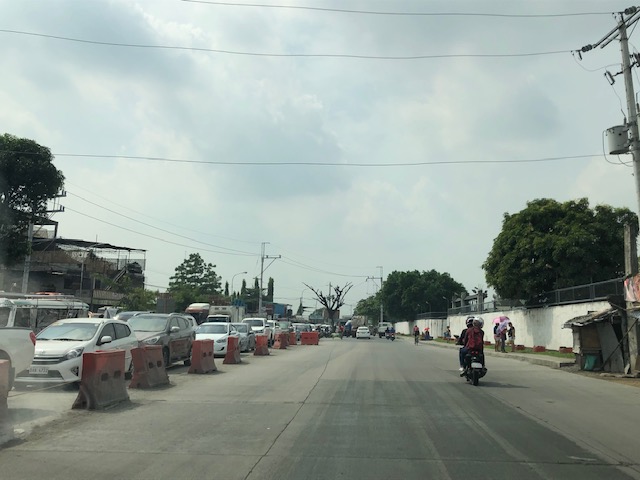 Even before completely crossing the bridge, one can see how long the queue from C-6 is. This is a photo of the queue just past the West Bank Road. The road here is names Ejercito Avenue after former Pres. Joseph Estrada whose real family name is Ejercito.
 Truck occupying an entire lane and encroaching on one of the lanes to C-6. This is due to the bottleneck caused by the wall of a residential subdivision across from the Greenwoods gate. The wall actually only contains the subdivision name and yet DPWH has been unable to expropriate the land that includes part of that subdivision’s driveway.
 Long queue extending towards Tapayan Bridge along Ejercito Avenue
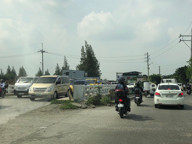 Queue along Tapayan Bridge or bridges considering there are two – one for each direction of traffic.
 Queue crossing the bridge and the bend towards C-6 and Lupang Arenda, which is a major relocation site for Metro Manila squatters during the time of then Pres. Joseph Estrada. Vehicles turn left towards C-6 while those going straight continue along Ejercito Avenue towards Pinagbuhatan, Pasig City.
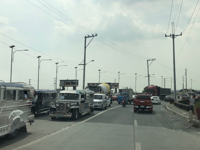 The queue reaches C-6 on a Sunday morning. It is likely worse on weekdays.
–
Status of Barkadahan Bridge, Taytay, Rizal
I recently wrote about the Barkadahan Bridge and its current state and compared it to the Marcos Highway Bridge that is now completed and fully opened to travelers. Unfortunately, I didn’t have photos to share but only shared my observations based on what friends have told me and what I’ve read on social media (i.e., Rizal Provincial’s and Taytay’s official Facebook pages) about the situation there. I finally had the opportunity last Sunday when I went to fetch my family at the airport. Here are photos of the Barkadahan Bride and its environs. Note that Barkadahan is actually two bridges and not one. The new one is currently being used for two way traffic (one lane each) while the second one is under rehabilitation and retrofitting. The latter had and will have 2 lanes, too.
 Approach to the Barkadahan Bridge via Highway 2000 – notice the widening on the south side of the highway? That’s the ROW expropriated to align the bridge(s) with the highway. Ultimately, this should be of the same width as C-6.
 Closer to the bridge, you see more of the ROW acquired to improve the geometry for the area and the intersection with the East Bank Road. Highway 2000 is now aligned with the second (newer) bridge constructed that will eventually carry only the eastbound traffic. The older bridge currently being rehabilitated and retrofitted will carry the westbound traffic.
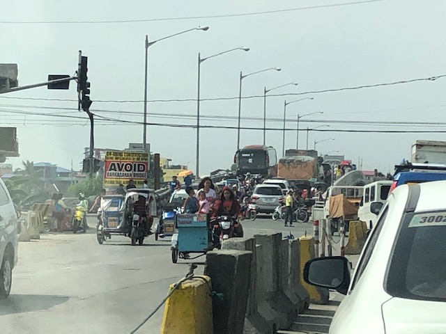 Vehicles crowd on the two-lane bridge that is the new Barkadahan Bridge. The old one is currently being rehabbed. Notice the significant volume of trucks using the bridge? This is expected to increase due to the industrial developments in Rizal Province and along C-6, and the direct route this corridor provides towards the SLEX via Bicutan.
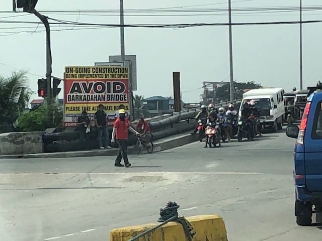 Big sign at the bridge – there are many of these scattered around Pasig and Rizal advising travelers against using the route and Barkadahan Bridge because for the construction work on the bridge. This ‘avoidance’ basically transferred (some say returned) much of the traffic to Ortigas Avenue Extension. Many if not most users of the bridge use this alternate route to travel from Rizal to BGC and Makati CBD.
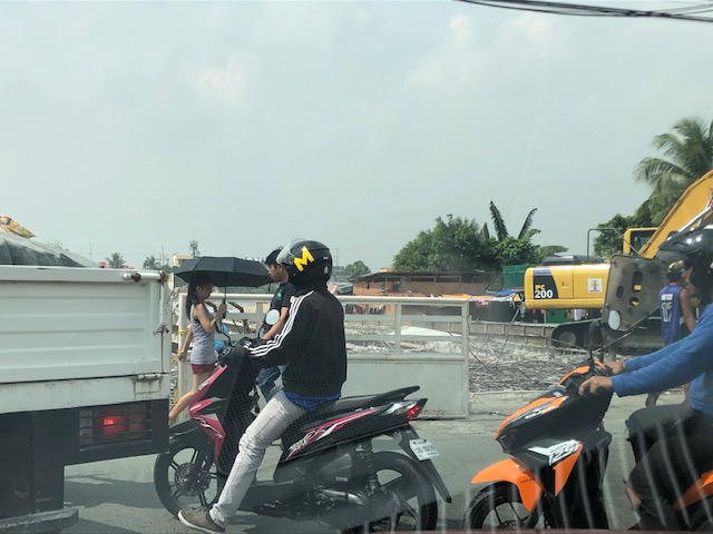 A peek at the construction work on the old bridge – note that the contractor seems to have completed installing the steel reinforcement for the slabs for this section of the bridge. The next phase would be the concrete pouring.
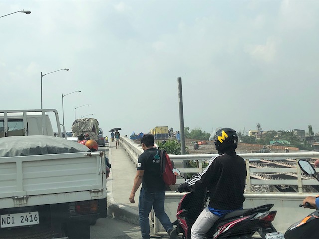 Still another peek showing the extent of the work on the old bridge – my casual observation of the work areas was that there seems to be not so many workers. But then maybe it was a Sunday? Perhaps there should be more people working considering this is a very urgent project?
 Tricycles, motorcycles and bicycles – there’s a lot of local traffic using the bridge and these are represented by mostly tricycles serving the residential and commercial areas along the East and West Bank Roads and the cyclists you most often see crossing the bridge. Most motorcycles are through traffic. On weekends one can observe more recreational cyclists as this route is a popular one to Rizal and particularly its mountainous areas that are popular to mountain and road cyclists.
 Counterflow – many motorcyclists tend to counterflow and this adds to the friction and slows down traffic. Once the other bridge is completed and re-opened, these will likely be reduced to lane splitting or filtering as the opposite flows of traffic will be assigned to separate bridges. Counterflow traffic will then be very obvious and should be apprehended.
 Here’s the resulting queue on the other side of the bridge. This is severe congestion that reaches C-6. Note that the photo was taken on a Sunday. Perhaps these travelers have no other option but to use this route so they are stuck in hellish traffic on a Sunday? I can only imagine how worse it is on weekdays.
As a parting shot, I think there are still a couple of things that need to be addressed once the bridges are both open to traffic:
- Optimizing traffic management at the intersections with the East Bank Road and West Bank Road of Manggahan Floodway – the (mis)management of traffic here also contributes to congestion in the area. Traffic enforcers on both ends of the bridge have basic knowledge of how traffic must be managed and end up with the “buhos” approach. They don’t seem to be coordinating with each other, too. Their approach also heavily favors the East and West Bank roads when traffic is heavier along the main corridor that is C-6/Highway 2000. There needs to be a more efficient way to manage traffic here and that may be in the form of a sophisticated traffic signal system at least for the two intersections. Settings need to be studied and signals have to be adaptive to the variation of traffic throughout the day.
- Resolve bottlenecks in the area including structures that tend to reduce capacities of the approaches to the bridge.
More on this topic soon!
–
On Tikling Junction traffic (mis)management
There was an uproar among commuters when Taytay installed traffic signals at the rotunda at Tikling Junction. The junction is the intersection of Ortigas Avenue Extension, which continues towards Antipolo, the Manila East Road, which connects many of Rizal Province’s towns, and Leonard Wood Road, which leads mainly to residential areas in Taytay. There is another road that is close to the junction, Cabrera Road, that qualifies the intersection to be an offset type. However, vehicle coming in and out of Cabrera Road mainly are with respect to the Manila East Road.
 Traffic signals as seen from the Manila East Road approach to the rotunda
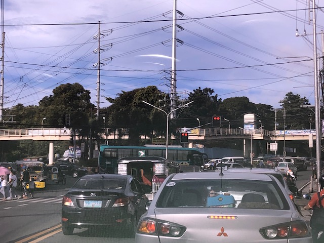 Traffic signals as seen from the Ortigas Ave. Ext. leg approach from Antipolo
The horrendous congestion last Thursday was due to the settings of the signals that forced most vehicles to stop even though there were movements that were not in direct conflict with others (e.g., through traffic along Ortigas Ave. Ext. from Antipolo towards the direction of Valley Golf/Cainta and right turning traffic from Ortigas Ave. Ext. to Manila East Road). The results were vehicles backed up all the way to Cainta Junction along Ortigas Avenue Extension and SM Taytay along the Manila East Road. We were able to experience the slight congestion the following day (Nov. 1) when we descended to Tikling from Antipolo. Congestion was slight probably because of the significantly reduced traffic due to the holidays.
I thought, based on experiences at this junction, that the traffic signal settings somewhat mimicked the style applied by Taytay traffic enforcers when they manually manage traffic at the intersection. Too often, they apply the “buhos” system where they try to let through all vehicles they see queued per approach. The outcome of this, of course, is longer stopped times to all other vehicles from the other legs resulting in longer and longer queues that become unmanageable especially during the peak hours (i.e., when vehicle arrivals are highest at the intersection). Basically, what happened last October 31 was that the “buhos” traffic enforcers were replaced by the machines (i.e., traffic signals) that employed the same system only this time there was no opportunity for some flexibility for movements that had none or the least conflicts at the intersection.
–
Cooperative work among LGUs to address transport problems along Ortigas Avenue Extension?
I saw a recent post about a meeting hosted by Pasig City. The Mayor of Pasig City recently held a meeting where he invited the mayors or Antipolo, Cainta and Taytay to discuss, among other things perhaps, transportation along Ortigas Avenue. Ortigas Avenue is a corridor shared by several LGUs most notably the Rizal towns of Antipolo (which is the provincial capital and a highly urbanized city), Cainta and Taytay. The latter two are among the richest municipalities in the country; a fact I underline here since that also should translate to them having the resources or means to help come up with transport and traffic solutions.
 Morning rush traffic starts very early these days. This photo was taken around 6AM on a Thursday along the westbound direction just after the Manggahan Bridge. The pedestrian overpass at C. Raymundo junction is shown and the dark colored buildings are at Robinsons’ Bridgetown development. Note the commuters along the right waiting for a ride.
Photos paint a thousand words. The Taytay Mayor attended the meeting. He has been under fire for the horrendous traffic caused by the mismanagement of Tikling Junction as well as the Barkadahan Bridge area that was and is supposed to be a major alternative route for Rizalenos heading to their workplaces in Makati and BGC. More recently, there were posts about the traffic signals installed at Tikling Junction that basically invalidates the roundabout concept for the junction. The result last Thursday, the first day of operations for the signals, was hellish traffic that backed up a couple of kilometers along the Manila East Road and Ortigas Ave. Extension (some reports say until Cainta Junction). This, even as the signal settings were supposedly done with help from the MMDA.
Antipolo was represented by its former Mayor and husband to the current one. He also happens to be a former Governor of the Rizal Province and likely to run again as his mother, the current governor, is on her 3rd term. It seems to me that the province is not so interested in solutions for Ortigas Avenue despite most of its constituents traveling through the corridor to get to their workplaces and schools. Marcos Highway is not the main corridor for Rizal towns as it basically carries only Antipolo and maybe some of Tanay (via Sampaloc) traffic. Ortigas Avenue Extension branches into two major roads from Tikling – Ortigas Ave Extension, which ends at the capitol, and the Manila East Road, which connects to practically all of Rizal towns with San Mateo and Rodriguez (Montalban) being the exceptions. It is time for the province to pay attention to this commuting problem experienced daily by her constituents.
The Mayor of Cainta seems not as interested as the others, sending a representative who appears to be not one of the top officials (the traffic chief with a rank of SPO1=Master Sergeant is lower ranked than a councilor) of the Municipality to such an important meeting. In fact, he is currently now embroiled in a controversial faux pas involving himself by not wearing a helmet while riding a motorcycle. What’s more is his downplaying this and appearing to be even justifying the act. He eventually apologized but not before stating his moves. He is not new to publicity (stunts?) and knows how bad publicity still translates to good publicity especially in this days of fake news and trolls (he apparently has many on social media). He seems to forget that transport and traffic solutions for Ortigas Ave will likely benefit anyone seeking reelection or higher office in Rizal. He is on his last term as mayor and the break-up with some of his allies including his former Vice Mayor who ran against him in the last elections shows the limits of his political career. What was rumored as plans to run for Rizal governor might just be downgraded to perhaps Vice Mayor? In any case, he should show more interest and effort in finding solutions beyond traffic management and not by himself but in cooperation with others with whom his jurisdiction shares the problems with. Perhaps the initiative of the Pasig Mayor presents an opportunity for such cooperative work? Many people are very interested in this and will be watching – and hoping.
–
Is there really a transport or traffic crisis in Metro Manila?
I was interviewed recently for a research project by students enrolled in a journalism class. I was asked by one in the group if we indeed have a transport crisis in Metro Manila. The other quickly added “hindi transport, traffic” (not transport but traffic). And so I replied that both terms are valid but refer to different aspects of the daily travel we call “commuting”. “Traffic” generally refers to the flow of vehicles (and people if we are to be inclusive) while “transport” refers to the modes of travel available to us.
“Commuting” is actually not limited to those taking public transportation. The term refers to all regular travel between two locations. The most common pairs are home – office and home – school. The person traveling may use one or a combination of transport modes for the commute. Walking counts including when it is the only mode used. So if your residence is a building just across from your office then your commute probably would be that short walk crossing the street. In the Philippines, however, like “coke” and “Xerox”, which are brands by the way, we have come to associate “commute” with those taking public transportation.
And so we go back to the question or questions- Do we have a transport and traffic crises? My response was we do have a crisis on both aspects of travel. All indicators state so and it is a wonder many including top government transport officials deny this. Consider the following realities for most commuters at present:
- Longer travel times – what used to be 30-60 minutes one-way commutes have become 60 – 120 (even 180) minute one-way commutes. Many if not most people now have double, even triple, their previous travel times.
- It is more difficult to get a public transport ride – people wait longer to get their rides whether they are in lines at terminals or along the roadside. The latter is worse as you need to compete with others like you wanting to get a ride ahead of others.
- People have to wake up and get out of their homes earlier – it used to be that you can wake up at 6:00AM and be able to get a ride or drive to the workplace or school at 7:00/7:30 AM and get there by 8:00 or 9:00AM. Nowadays, you see a lot of people on the road at 5:30AM (even 4:30AM based on what I’ve seen). That means they are waking up earlier than 6:00 AM and its probably worse for school children who either will be fetched by a service vehicle (e.g., school van or bus) or taken by their parents to their schools before going to the workplaces themselves.
- People get home later at night – just when you think the mornings are bad, afternoons, evening and nighttimes might even be worse. Again, it’s hard to get a ride and when you drive, traffic congestion might be at its worst especially since most people leave at about the same time after 5:00PM. Coding people and others not wanting to spend time on the road (instead working overtime – with or without additional pay) leave for their homes later and arrive even later.
- Less trips for public transport vehicles – traffic congestion leads to this. What used to be 6 roundtrips may now be 4. That affect the bottomline of income for road public transport providers. Given the increased demand and reduced rolling stocks of existing rail lines that includes rail transport.
To be continued…
—
Ortigas Center congestion
A couple of Thursdays ago, I was in the Ortigas CBD area to attend a conference on statistics. I hitched a ride with an old friend who was also going there and so we had some time to catch up on life and other topics we usually talked about since our college days. Being on the passenger seat also meant I had some opportunities to take photos of the traffic situation in the vicinity of the venue of our conference. Here are some photos I took of traffic in the Galleria – ADB area as we drove along ADB Avenue.
 Congestion along ADB Avenue across from Robinsons. The ADB building is shown ahead of the vehicles.
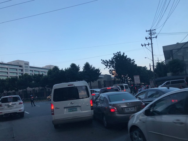 Most of the vehicles turned out to be turning towards Guadix and headed for Poveda. These are traffic generated by the exclusive school where most if not all students’ mode of transport is by car. This causes much of the congestion in the area at this time of day as well as during dismissals in the noontime and afternoon.
 Vehicles bound for Poveda (building is in the background) and EDSA.
 View of Ortigas bound vehicles filed along Sapphire Road – this photo was taken at the bridgeway connecting Crowne Plaza and Holiday Inn. The relatively uncontested road is the Robinsons’ driveway.
The photos show how dependent to cars many people working in the Ortigas CBD are. Many of them live outside of the CBD including those residing in the Rizal towns to the east of Metro Manila. The number of people using their own cars put so much strain on the major thoroughfares including and perhaps especially Ortigas Avenue, which serves as a main arterial connecting the CBD to many parts of Pasig, Quezon City (via C5) and the very progressive towns of Rizal Province such as Cainta, Taytay and Antipolo City.
It is a wonder why up to now, there is no mass transit system along Ortigas Avenue when the demand is very high and continuous to increase with the development of lands along it. SM, Robinsons and Megawide are among the major players now developing their plots of land to become high density commercial/office/residential areas. And these will surely translate into more trips generated and worse traffic congestion. Perhaps the mayors of Pasig, Cainta, Taytay and Antipolo plus the governor of Rizal can get together to discuss and agree about solutions where each LGU can contribute for the betterment of their constituents’ commutes?
–
The Barkadahan Bridge situation
The Barkadahan Bridge is currently undergoing rehabilitation. To be accurate, the old bridge is being rehabilitated and upgraded/retrofitted to be able to carry the traffic projected to use it being a vital link between the Province of Rizal and Metro Manila via Pasig and the C-6 corridor. The bridge is named after the “friendship” established among Rizal municipalities and Pasig City for an area that has been subject of a territorial dispute among them. These are the municipalities of Cainta and Taytay (Rizal Province) and the city of Pasig. The bridge spans the Manggahan Floodway, much of which is in Pasig City.
To increase the capacity for this crossing, which is the most direct route to C-6 and popular among many headed to Taguig/BGC and Makati, a new bridge had been constructed to the south of the old one. The older one had 2 traffic lanes and was no longer sufficient for the volume of vehicles crossing it after the expansion of C-6 resulting to it steadily gaining more users over the years. Use of this route cut down travel times between Rizal and BGC and Makati by at least 30 minutes based on our experiences using the route.
Late last year as far as I could recall, the new bridge opened and immediately increased capacity but then congestion quickly set-in due to two factors: the traffic management at the intersection with the East Bank Road and the constrained (two-lane, two-way) leg of Highway 2000. Add to this the lack of discipline by local traffic in the form of tricycles and motorcycles counter-flowing in the area.
Earlier this year, signs were posted around Rizal about the then impending project for the rehabilitation of the old bridge. The signs advised for most travellers to avoid using the Barkadahan Bridge due to the congestion in the area because of the project. It turns out that what was thought by most as a project retrofitting the old bridge alone was actually a bigger one involving increasing the capacity of the Highway 2000 leg of the intersection with the East Bank Road. Following is a photo posted at the official Facebook page of the Rizal Provincial Government showing the demolition of buildings and other structures along the Highway 2000 leg. The photos were taken from the new Barkadahan Bridge approaching the intersection, the southbound direction of the East Bank Road, and from the westbound side of Highway 2000.
 Demolition and clearing of ROW for the expansion of Highway 2000 in relation to Barkadahan Bridge [Photo collage from the Lalawigan ng Rizal Facebook page]
From the photos above, it is clear that at least 2 lanes will be added to Highway 2000 and that this leg will soon be well-aligned with the Barkadahan Bridge, which will also have a total of 4 lanes. Hopefully, this project will be completed soon and within the year (before December?) in order to alleviate the commuting woes of Rizalenos working in the BGC and Makati CBD areas. Of course, that goes without saying that there is also a need to optimise the traffic signals at the intersection and to strictly enforce traffic rules and regulations vs. erring motorists in the area.
–
On commuting characteristics in Metro Manila – Part 1
A friend posted the following two graphics showing commuting characteristics derived from a recent survey they conducted online. The 327 respondents are not much compared to the more comprehensive surveys like the ones undertaken by JICA and there are surely questions about the randomness of the survey. Online surveys like the one they ran can be biased depending on the respondents. This was mainly done via social media and through certain interest groups so statistically there may be flaws here. Still, there is value here considering there is often a lack of hard data on commuting characteristics especially those that are recent or current. We need these to properly assess the state of transportation or travel in Metro Manila and elsewhere.
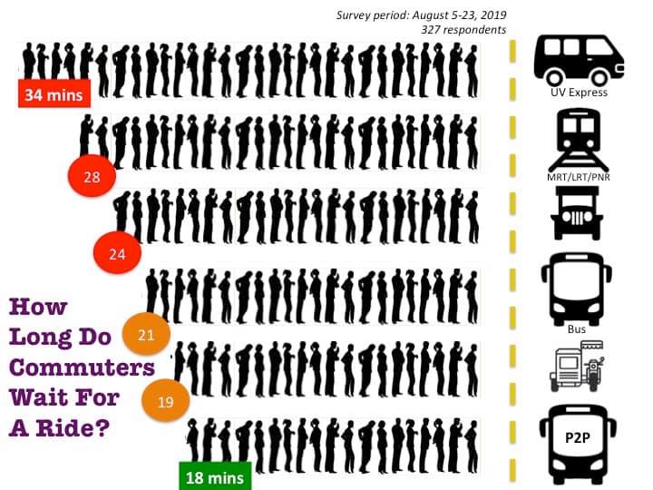 What’s lacking? Information on car and motorcycle users? And why the long waiting times? Are these really just because of a shortage in the supply of public transport vehicles thereby necessitating additional franchises? [Graphic and data courtesy of Toix Cerna via Facebook]
 Again, the mode shares reported are incomplete. With the exception of walking, car and motorcycle shares are substantial and significant. There is some info here about trip chains (i.e., the average of 2 rides per commute) but it is unclear what percentage of the trip is made using whatever mode is used. [Graphic and data courtesy of Toix Cerna via Facebook]
The absence of information about cars and motorcycles is glaring due to their significant share of commuters. Yes, the term ‘commuter’ actually refers to someone who regularly travels between home and office. By extension, this may also apply to travels between home and school. The term is not exclusive to public transport users as is often assumed. Walking between home and office qualifies as a commute.
I am curious about how commutes using cars and motorcycles would compare to public transport commutes. The comparison is quite useful to show, for example, the advantages and disadvantages of car use (this includes taxis and ride share). More detailed information may also reveal who among car or motorcycle users use these vehicles out of necessity rather than as one among many choices for their commutes. One thinking is that if public transport quality is improved, then many people will opt to use PT rather than their private vehicles. However, there is also the observation that in many cases, those already using PT are the first to shift from the lower quality service to the better one. I also wrote about this as I posted my worries about how successful can Line 7 and Line 2 extension be in reducing car use along their corridors. Perhaps the ones who will truly benefit are those who are already taking public transport, and car and motorcycle users will just continue with these modes?
In Part 2, I will share some data we collected more than a decade ago for a study on jeepneys in Metro Manila. I will use the information to explain another angle of this issue on public transport supply and demand.
–
Traffic management schemes for the Marcos Highway bridge rehab
The rehabilitation of the Marcos Highway Bridge in Marikina has necessitated traffic management schemes at the bridge itself and along alternative routes to alleviate congestion in the area. These are collectively called traffic or transport systems management (TSM) schemes with the objective of optimising existing infrastructure and resources without necessarily building something entirely new. These are quite different from travel demand management (TDM) schemes that include number coding and truck ban policies that are already being implemented (though Marikina does not implement the number coding scheme).
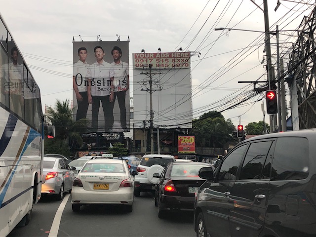 Traffic build-up at the approach to the intersection with FVR Road (To Riverbanks). This is now a signalised intersection as traffic from Blue Ridge/White Plains is now allowed to cross to FVR Road.
 Using the route via FVR Road (Riverbanks) means you don’t have to cross the Marcos Highway Bridge and travellers will merge with those who crossed the bridge just before the Line 2 Santolan Station.
 In the mornings, one lane each is allocated for either the eastbound or westbound traffic. That’s practically a total of 3 lanes (+2 lanes westbound for the SM Marikina Bridge) for the westbound direction and a single lane for the eastbound side. This is logical given the directional distribution of traffic at this time of day and the alternative routes already available to travellers.
Here are a few photos taken on a night time drive. Note that this was taken by a passenger. Don’t even try doing this (taking photos) while driving a vehicle, and especially not while on a motorcycle.
 Entrance to the bridge right after Maj. Dizon – this part is not affected by the rehab works but vehicles position themselves to shift towards the left side, which is the usable part of the bridge.
 Both lanes of the westbound side of the bridge are used for eastbound traffic. Westbound traffic are all along the SM Marikina bridge for a total of 2 lanes each for either direction of flow. The cones are not removed for practicality since they would have to be installed for the morning when one lane is allocated for the westbound traffic.
 Vehicles shift to the right to return to the correct lanes for eastbound traffic along Marcos Highway at the Santolan area. Note the westbound vehicles shifting towards the underpass and SM Marikina on the left.
–

