
Home » Traffic Engineering (Page 8)
Category Archives: Traffic Engineering
2014 Professorial Chair lectures on transport topics
The 2014 Professorial Chair Colloquium of UP Diliman’s College of Engineering was held from yesterday until today. Most of the lectures concerning transport were presented today. Here are some of the highlights of the lectures delivered this morning:
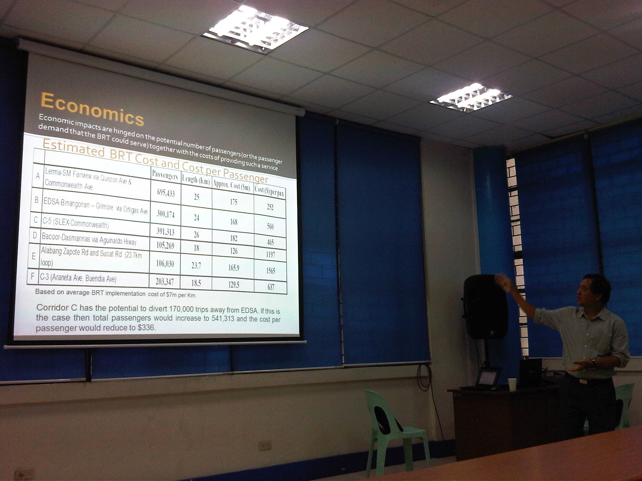 Dr. Ric Sigua, Director of the Institute of Civil Engineering, making a point about the economics of Bus Rapid Transit (BRT).
 Dr. Sean Palmiano, Director of the National Center for Transportation Studies, explaining the finer points of traffic impact assessment for high density residential developments.
 Prof. Happy Denoga of the Department of Mechanical Engineering explaining on the advantages of hybrid systems for vehicles.
 Dr. Karl Vergel of the Institute of Civil Engineering talking about the on-road tests for jeepneys using B5 or 5% CME-blended fuels in a project commissioned by the Philippine Coconut Authority.
 Comparison of jeepney mileage using 2% and 5% blended fuels.
 Dr. Edwin Quiros of the Department of Mechanical Engineering’s Vehicle Research and Testing Laboratory (VRTL) discussing the dynamometer tests conducted for jeepneys using B5 fuel.
There were other presentations but unfortunately, I wasn’t able to attend these as lectures were spread among various venues at the college. That’s often the hang-up of having parallel sessions during these colloquiums. Nevertheless, it is nice to know that transport remains a popular subject for these lectures.
–
How to get rid of traffic jams using intelligent transport
I came across a few more online articles recently and this time one article featured mostly intelligent transport systems (ITS). ITS has been around for quite some time now and the big difference between now and a couple of decades ago is the cost for these systems. I would not delve into the details of ITS, and leave it up to the reader to perhaps google about this and all the different types of ITS.
The article “Here’s How to Get Rid of Traffic Jams” presents the various systems that have been implemented in other countries. Some have been implemented one way or the other in some parts of the Philippines, particularly the coordination of traffic signals (Manila, Cebu, Davao) but most have not even been attempted so there’s a lot of room for the improvement especially where congestion is becoming more serious and unmanageable due in part to limitations among agencies and the people themselves who are involved in transport and traffic management.
It also refers to a study on traffic congestion that was conducted for Los Angeles, CA. Reading through the document I couldn’t help but note that much of what LA has experienced and is still experiencing describes what we also try to deal with in Metro Manila and other major Philippine cities. Be sure to browse for the full document and not just the summary for the study. There are also a lot more materials on transport that you can find this website so be sure to bookmark Rand’s website.
–
Food for thought – a few articles on transport and traffic
This will just be a quick post for now and I just wanted to share a few recent articles on transport and traffic from a favourite magazine – Wired:
What’s Up With That: Building Bigger Roads Actually Makes Traffic Worse
Why We’re Sad the Best Airport in the World Is Getting Even Better
The Hidden Genius and Influence of the Traffic Light
These are very well written, easy to understand articles on things we encounter everyday (traffic congestion, traffic signals at intersections) and when we travel long distance (airports). They show different perspectives of things we take for granted or assume we understand. An example of the latter includes notions that road widening or road construction will solve traffic congestion problems. Much of what goes around regarding road widening or road construction as solutions do not account for induced demand, which is basically additional traffic generated or encouraged by wider or new roads. The second article talks about Changi Airport, arguably the best in the world, and the high tech approaches they have employed or will employ in order to ensure efficient operations there. Such tools, I think, should be used in our airports especially NAIA where the long standing excuse is the limitations of the runway(s) and the airport terminals. Certainly, there are other issues that need to be addressed and going high tech and employing sophisticated methods for airport operations should alleviate problems until we ultimately build a new airport elsewhere. The third article takes a look into behaviour and mentions a “social contract” we have agreed to in order to reduce mayhem in our roads. This “social contract” as well as others related to it should be revisited and understood as they are very much a part of how we behave when we travel and have a significant effect on others around us.
 Traffic congestion and traffic signals along the 4-lane C.P. Garcia Avenue in UP Diliman
–
Dissertation defense
After a series of posts on my recent travels, here’s something on the serious side:
The oral defense of the dissertations of Ph.D. in Civil Engineering (Major in Transportation Engineering) Program doctoral candidates, Mr. Ernesto B. Abaya (staff/affiliate student/ERDT scholar) and Mr. Alex S. Ladaga (affiliate student/CHED scholar) with topics on transportation & environment and traffic flow theory, respectively, will be on October 21, 2013 (Monday) from 9:00 AM and from 1:00 PM at the National Center for Transportation Studies. Details are shown below:
ERNESTO B. ABAYA
“DEVELOPMENT OF DRIVE CYCLES & ESTIMATION OF FUEL CONSUMPTION FACTORS OF LIGHT DUTY VEHICLES IN METRO MANILA”
21 October, 2013, Monday, 9:00 AM at the Toyota Training Room, NCTS, UP Diliman
Dr. Edwin N. Quiros (UPD-DME), Panel Chair
Dr. Hilario Sean O. Palmiano (UPD-ICE), Panel Member
Dr. J. B. Manuel M. Biona (DLSU-COE), Panel Member
Dr. Karl B. N. Vergel (UPD-ICE), Panel Member (Adviser)
Dr. Ricardo G. Sigua (UPD-ICE), Panel Member (Co-adviser)
Abstract: The urban drive cycles for five different light duty vehicles (LDV) are developed in this study. Furthermore, the fuel consumption factors for each of the type of LDV are estimated. The study presents the methodology in the development of the drive cycles in which the speed profile of the specific type of vehicle is surveyed, downloaded and processed. In the survey of speed data, a Global Positioning System (GPS) device is used as an on-board instrument. The GPS device is placed on the dashboard of every surveyed vehicle and it recorded instantaneous speed in its memory. The speed data is downloaded from the device using software provided by the maker of the device (Garmin) called Mapsource. The speed data is processed using a program to execute the methodology in generating candidate drive cycles. The program creates drive cycles by randomly appending microtrips to form a minimum of twenty minute speed time profile. Furthermore, along with the generated drive cycle, the program also indicated how it compared with the target drive cycle by computing their individual absolute value difference of their joint speed-acceleration probability distribution. Ten drive cycles for each type of LDV are developed which have absolute value differences less than 20%. The final drive cycle is selected from the ten (10) candidate drive cycle developed from each type of LDV. The selected drive cycles are then used in the Vehicle Research and Testing Laboratory at UP College of Engineering, Mechanical Engineering Department, to estimate the fuel consumption factors of each type of light duty vehicle considered. The developed drive cycles for the different types of light duty vehicles, namely (1) private cars, (2) taxicabs, (3) public utility jeepneys, (4) asian utility vehicles express, and (5) light cargo vehicles have average speeds of 17.97 kph, 13.57 kph, 10.87 kph, 14.69kph and 8.43 kph respectively. The fuel consumption factors estimated for all the light duty vehicles tested in the chassis dynamometer laboratory ranges from 9 to 12 km/liter.
Keywords: light duty vehicles, drive cycles, chassis dynamometer laboratory
—
ALEX S. LADAGA
“EFFECTS OF GAP FORCING ON THE CAPACITY OF TWO LANE ROUNDABOUTS IN THE PHILIPPINES”
21 October, 2013, Monday, 1:00 PM at the Toyota Training Room, NCTS, UP Diliman
Dr. Karl B. N. Vergel (UPD-ICE), Panel Chair
Dr. Jose Regin F. Regidor (UPD-ICE), Panel Member
Dr. Hilario Sean O. Palmiano (UPD-ICE), Panel Member
Dr. Ma. Sheilah G. Napalang (UPD-SURP), Panel Member
Dr. Ricardo G. Sigua (UPD-ICE), Panel Member (Adviser)
Abstract: Traditional method in estimating roundabout capacities using gap acceptance theory involves the assumption that vehicles entering the roundabouts give way to vehicles running along the circulatory road. Parameters usually used include the critical gap and the follow up times used by the entry vehicles. Gap forcing persists in local roundabouts and this common Filipino driver behaviour renders the existing models derived from traditional assumptions unsuitable for local applications. The study embarks on the development of the simulation model which takes into account gap forcing in the estimation of capacity of roundabouts in the Philippines. It explores the feasibility of introducing more realistic driver behaviour assumptions and the inclusion of additional parameters to come up with a model suitable for local use.
Keywords: roundabouts, gap forcing, capacity
—
Some issues on pedestrian crossings at signalized intersections at BGC
I had heard from friends working at Bonifacio Global City in Taguig that it is difficult for pedestrians to cross at intersections at BGC. For one, the cycle settings (i.e., movements allowed for every green signal) for the intersections, at least those I’ve seen, often had turning traffic in direct conflict with pedestrian crossings. This meant that while given the green light to cross the street, for example, pedestrians had to contend with left turning as well as right turning vehicles who are also allowed movement for particular green phases. The phasing and the cycle settings are definitely more favorable to motor vehicles and assume that motorists will give way to pedestrians already on the carriageway and crossing the street. This is not the case and motorists tend to assert their way against pedestrians. These pedestrians are not jaywalkers but actually have the right of way by virtue of them getting the green light to cross. There is also that frequently violated rule of vehicles having to give way to legitimate crossings when people are already on the road. This is practiced in many other countries including the US, Japan and Singapore but is lost upon our motorists who seem to believe they own the road.
Another situation I’ve observed and personally experienced is the insufficient amount of time allocated for pedestrians to cross streets. This is particularly true for the wider streets of the Fort where it seems the people who set the signal cycles failed to estimate how much time it requires for people to cover the distance from one side of the roa to the other. What’s more is that the pedestrian settings allow only one or two people to cross at a comfortable pace. That is, other people will have to rush or run to be able to cross. Of course, the pedestrians would have to contend with the
 Intersection of 26th Street and 5th Avenue (view along 26th and towards 4th) – notice the green light given to through and left turning traffic as well as the signals for pedestrians, which include countdown timers.
 26th and 5th (view at the corner facing the Net Lima building)
 26th and 7th (view from the corner towards The Fort)
The solution to this issue about pedestrian crossings is a little bit more tricky that what seems like something that can be addressed by a simple adjustment of signal settings to provide more time for pedestrians. There is a need to revisit the phasing scheme for vehicle movements allowed at the intersections. Then there is also a need to find the optimum cycle and green time allocations considering the requirements for pedestrians and not just for vehicles. I believe whoever is in charge of the signal settings at BGC should look into this and if they are not capable of adjusting the settings then they should require the provider of the signals to make the necessary adjustments if not show them how to do this considering that traffic is quite dynamic and settings would need to be programmed to be responsive to demand not just for vehicles but pedestrians as well. BGC has great potential to be a pedestrian friendly CBD but whoever is in charge of transport planning and development should step up and level up, so to speak, in providing an environment that will encourage people to walk rather than take their cars. High Street is already there and is an important element in that mix of development but then the cluster of offices and residential condos aren’t exactly designed for efficient walking, and the settings for the intersection signals, as we pointed out, need to be adjusted for pedestrians.
–
Traffic congestion and the limits of quick fixes
One time last summer night, it took me 2.5 hours to get to the airport from where I reside when it should only be an hour or 1.5 hours (on a typical bad day). Very early mornings (between 2 to 4 AM), it only takes me 40 minutes between my home an the airport. The route I usually take is mainly along Circumferential Road 5 (C-5); a route that basically has sparse public transport (mostly jeepneys along different sections) but is a truck route. It was summer though and one would have thought that there would be less vehicles along the road with school still out. I was wrong in that assumption and that cost me both time and fuel that night.
Traffic congestion in Metro Manila and other Philippine cities have been issues for such a long time that one tends to assume there’s nothing being done to fix the problem. In Metro Manila, the Metropolitan Manila Development Authority (MMDA), in cooperation with the various local governments and national agencies, has implemented various schemes including the number coding, truck ban and a bus dispatch system along EDSA. Yet, congestion persists and only last week, the President got caught in traffic as he traveled from Malacanang Palace in Manila to the DOST Compound in Taguig. The news was filled with a comment that he supposedly made to the MMDA Chair about the delay he and his entourage experienced. The bad news is that this congestion will not go away and will only worsen if there are no steps taken to address the problem. And this happens not only in Metro Manila but in other highly urbanized cities in the country. Quite obviously, quick fixes are no longer enough and we have reached the limits of their applicability.
 EDSA during the morning rush hours
 EDSA during the afternoon peak, which actually extends to an evening and even nighttime traffic jam
So how do we alleviate traffic congestion? Here’s three things that come to mind as they seem to be quite logical and very obvious:
1. Build the mass transit infrastructure required – these infra include rail and bus rapid transit systems and are urgently needed in Metro Manila, Metro Cebu, Davao and other highly urbanized cities. A shift from private vehicle use to public transport will not happen if people have no attractive options for commuting. In Metro Manila, there is a backlog of mass transit projects with lines that should have been constructed and operational years or even decades ago.
2. Rationalize transport services – the long standing practice is to increase the number of existing modes of transport as the demand increases. This logic is one that is most abused as a doubling of demand is conveniently but incorrectly interpreted as requiring a corresponding doubling of the number of tricycles or jeepneys, for example. What is required is for our cities to “graduate” from low capacity and less efficient modes to higher capacity and more efficient ones. Many cities seem plagued with tricycles as their main modes of transport within their CBDs when these should have been restricted to residential areas and mainly in the periphery rather than allowed to dominate (and clog) urban streets.
3. Build more walkways and cycling facilities – its difficult to encourage people to walk and cycle if there are no space for pedestrians and cyclists to travel safely and efficiently. Most trips are actually short ones and do not require motor vehicles so it makes sense to invest in pedestrian and cycling facilities so people get the clear message of support for such options for travel. Such investment is also one for healthy living as walking and cycling are forms of exercise and it is well established that these modes of transport promote healthier lifestyles and therefore, healthier people in cities.
–
Special lectures on Traffic Engineering and ITS
The National Center for Transportation Studies hosted a series of lectures by a visiting professor last November 27 and 28, 2012. The lectures were delivered by Dr. Takashi OGUCHI, Professor, Department of Human and Social Systems and the Advanced Mobility Research Center of the Institute of Industrial Science of the University of Tokyo. Dr. Oguchi is currently a Visiting Professor under the Engineering Research and Development for Technology (ERDT) Program of the Department of Science and Technology (DOST) and is hosted by the Institute of Civil Engineering (ICE) of the UP Diliman College of Engineering.
The lecture on Nov. 27 was on Traffic Engineering and was well attended by students, UP staff and guests from government agencies. Dr. Oguchi lectured on the basic concepts of traffic flow theory including bottleneck phenomena.
 Dr. Oguchi talking about traffic congestion
 The NCTS Toyota Training Room was full with participants including students, staff and guests from government agencies.
 Dr. Oguchi explaining about the difference between time mean speed and space mean speed using an illustrated example.
The lecture on Nov. 28 was on Intelligent Transport Systems (ITS)
 Dr. Ric Sigua of the ICE introduces Dr. Oguchi before the latter’s lecture. Like the previous lecture, the venue was full with attendees from UP and government agencies.
 Dr. Oguchi also spoke about the ITS World Congress to be held in Tokyo next year.
 Dr. Oguchi fields a question from Dr. Eric Cruz of the ICE during the open forum right after the lecture.
–
Completed Quezon Avenue-Araneta Avenue underpass
The underpass along Quezon Avenue at its intersection with Araneta Avenue was finally completed and opened to traffic last September 28, 2012. It is perhaps one of the most anticipated inaugurations of infrastructure for Metro Manila and not an anti-climactic one like what was hyped as the completion of the loop formed by MRT3 and LRT1 a few years ago. That didn’t turn out well as we now know there is no loop at all with real connection of the two rail lines. But that, as they say, is another story worth another post or two.
Based on reports from different people including our office’s drivers and some colleagues, traffic has significantly improved in the area. The only joke going around is if the underpass will not be a catchment for floodwaters should there be strong rains considering that it was flooded during construction due to its proximity to the San Juan River and the perennially flooded areas of Talayan and Espana. There are, of course, pumps that have already been installed for the underpass to reduce if not eliminate the possibility of flooding. Following are a few photos taken one Saturday mid-morning when I passed along the area.
 A view of the approach to the underpass from Banawe. The pedestrian overpass is across Sto. Domingo Church.
 The section has 4 lanes with opposing traffic physically separated by a median island. The fence is likely to prevent jaywalking as well as maybe dissipate glare from headlights during night time.
 Potted plants have been placed along the median and though perhaps more are needed, I am glad there are no concrete balls that look like goat poop used to “decorate” the underpass. Columns and girders support the underpass walls at near the junction with Araneta Ave.
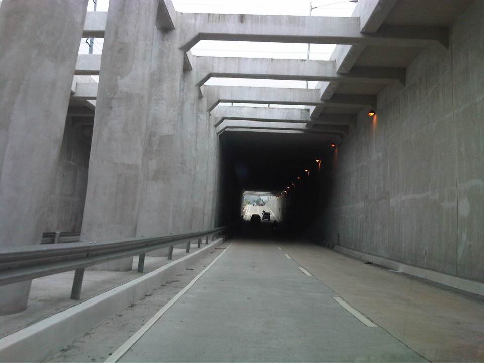 Approaching the section directly under Araneta Avenue, the first impression is that it is quite dark though motorists can see the end of the underpass. Pumps have been installed to drain water from this lowest parts of the underpass and prevent it (or reduced) from being flooded during times of strong rains.
 The end of the tunnel is practically a mirror image of the other. There are few potted plants as shown and perhaps more are needed to soften the look of the underpass as well as to reduce headlight glares.
 Back at-grade – emerging from the underpass, motorists will eventually merge with the traffic along the wide sections of Quezon Avenue. On the opposite direction, I noticed some congestion for vehicle emerging from the underpass as there is a U-turn slot a few meters from the ramp at the Banawe area.
There are traffic signals to manage flows at the at-grade junction of Quezon Ave. and Araneta Ave. It is expected that by reducing the volume of through traffic along Quezon Ave., the signals would be able to handle the remaining traffic and that the intersection will not be as congested as the case prior to the construction of the underpass. Of course, I would also like to see for myself how traffic is in the area during the regular weekdays, particularly on the typically busy days of Monday and Friday.
–
Quezon Ave. underpass at Araneta Ave.: some expectations and issues
The underpass along Quezon Ave. at its junction with Araneta Ave. is set to open to general traffic this coming week. I got this from a reliable source who was involved in the project as well as friends from the DPWH and the MMDA. If the opening pushes through, the underpass is expected, based on analysis, to ease traffic along both major roads with Quezon Avenue’s through traffic having the most benefit from the uninterrupted flow provided by the underpass. At-grade traffic management at the intersection will still be provided mainly by traffic signals but the substantial reduction of traffic attributed to the through movements along Quezon Ave. The reduction of congestion comes as a relief to a lot of travelers as well as businesses affected by the construction of the underpass in the last year. Fortunately, there has been little delay in the construction and so it seems that lost times due to construction-related congestion (translated here as sacrifices for those who had to endure daily traffic congestion and had to adapt to the situation) will finally be compensated for. Many, indeed, have been anticipating the eventual opening of the underpass, expecting the facility to solve congestion in the area.
The area has been subject to flooding considering its proximity to the San Juan River. Official data for flood occurrences in the area can be accessed through the Department of Science and Technnology’s (DOST’s) Nationwide Operational Assessment of Hazards website where it is clear that flooding will be an enduring problem for the underpass and surrounding areas. Recent reports (from last week until today) indicate that there is still the specter of flooding that will have to be addressed given that prior to the construction of the overpass, this issue had already been flagged by various stakeholders including the Quezon City Government. It is for this reason that the underpass will have pumps to ensure that water will not accumulate and lead to the closure of the facility in times of heavy rains resulting in flash or regular flooding.
–
Professorial Chair 2012 presentations on Transportation
The Transportation Engineering Group of the Institute of Civil Engineering of the University of the Philippines Diliman held a special session for its Professorial Chair Lectures last August 10, 2012 at the Toyota Training Room of the National Center for Transportation Studies. Four lectures were delivered by ICE faculty members who are also Research and Extension Fellows at the NCTS. Following are a few photos taken during the colloquium.
 Dr. Sean Palmiano presenting on the Investigation of Road Crash Causal Factors in Metro Manila (DMCI Developers Professorial Chair)
 Dr. Karl Vergel presenting on the Design of Traffic Signal Timing and Traffic Impacts of the Re-Introduction of Traffic Signal Control at the Intersection of the University Avenue and Commonwealth Avenue (Maynilad Professorial Chair)
 Dr. Ric Sigua presenting on Microscopic Simulation: A Tool for Evaluation of Traffic Schemes (Prof. Emeritus Norbert S. Vila Professorial Chair)
 Dr. Regin Regidor presenting on Revisiting the Costs of Traffic Congestion in Metro Manila and their Implications (Pozzolanic Philippines, Inc. Professorial Chair)
 Audience consisting of various participants including those from the DPWH, DOTC and MMDA who were invited for the colloquium.
 Graduate students and technical staff from the College of Engineering and the National Center for Transportation Studies also attended the lectures. Unfortunately, classes were suspended that week due to the monsoon rains that resulted in widespread flooding in Metro Manila so undergraduate students were not able to attend the colloquium.
The presentation files may be found in a previous post where links for downloading are provided. These may also be found in the NCTS website.
–
