
Home » Traffic Management (Page 22)
Category Archives: Traffic Management
Road and drainage improvements along Marcos Highway – Part 2
Previous posts on Marcos Highway road works and the resulting congestion did not include photos and discussions on a significant section of the highway. This is the stretch that runs from P. Tuazon/Imelda Ave. to Masinag Junction, where Marcos Highway intersects with Sumulong Highway. Some friends have pointed out the bottlenecks that include Masinag Junction itself and the uncompleted work in the vicinity of the newly opened SM City Masinag. Following are a few photos I took on a Saturday morning while traveling along that stretch of road and a few observations pertaining to some causes of congestion.
 Unfinished drainage and roadworks along eastbound direction of Marcos Highway approaching Golden Meadows gate – note that materials occupy practically 2 lanes of the highway.
 Construction along Marcos Highway eastbound in front of AMA Computer College just after Filinvest East Gate – only 3 lanes available to traffic, sometimes 2 due to heavy equipment maneuvers.
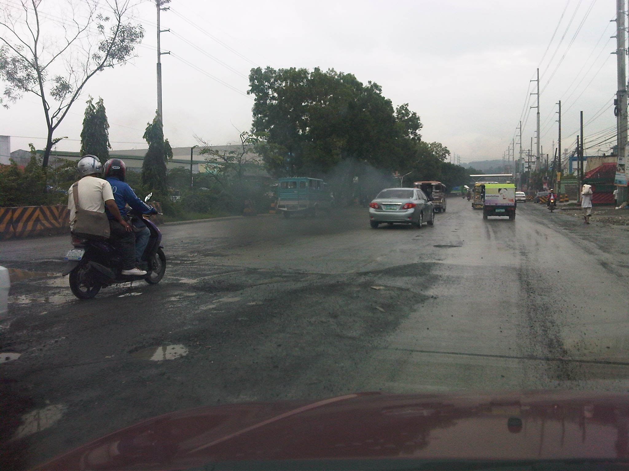 Unfinished road works near Kingsville Gate along Marcos Highway eastbound – bad road conditions lead to congestion as vehicles are forced to slow down due to the potholes and uneven pavement surface.
 Completed PCC pavement sections along Marcos Highway eastbound approaching SM City Masinag area – note that standard signs and pavement markings are still lacking along completed sections. Perhaps there is also a plan to have asphalt overlay as a protective or weathering layer for the concrete slabs?
 Completed section and newly constructed pedestrian overpass across SM Masinag – despite the overpass, many people still brave crossing the wide highway and risk getting run over by speeding vehicles.
 Jaywalking and risky crossing at Masinag Junction – I think traffic enforcers usually fail in managing pedestrians and cyclists crossing at the intersection resulting in the decrease in the throughput of the intersection. In any case, poor control may just lead to a road crash involving pedestrians and/or cyclists.
 More pedestrians crossing at Masinag junction – in this case, the only conflict is with vehicles turning right from Sumulong Highway.
 Another look at the new pedestrian overpass across SM Masinag along Marcos Highway westbound – this was a necessary facility for the safety of people (likely shoppers) crossing the 8-lane highway. The overpass would probably have to be modified later should LRT Line 2 be extended towards Antipolo City.
 Concrete barriers delineating lanes intended for vehicles making a U-turn along Marcos Highway just after SM Masinag – the barriers are also meant to reduce weaving caused by vehicles generated by the mall and intending to make the U-turn. These barriers, however, are also hazards as vehicles accelerating after Masinag will suddenly encounter these without adequate warnings. At present the lane is blocked right after the median opening due to uncompleted roadworks. Thus, erroneously entering the leftmost lanes will require a U-turn. Such barriers would have to be removed so traffic can still opt to pass through the section.
 Unfinished section along Marcos Highway westbound – the number of lanes are reduced from 5 to 2, drastically reducing capacity and causing serious queuing due to the shockwave resulting from the bottleneck.
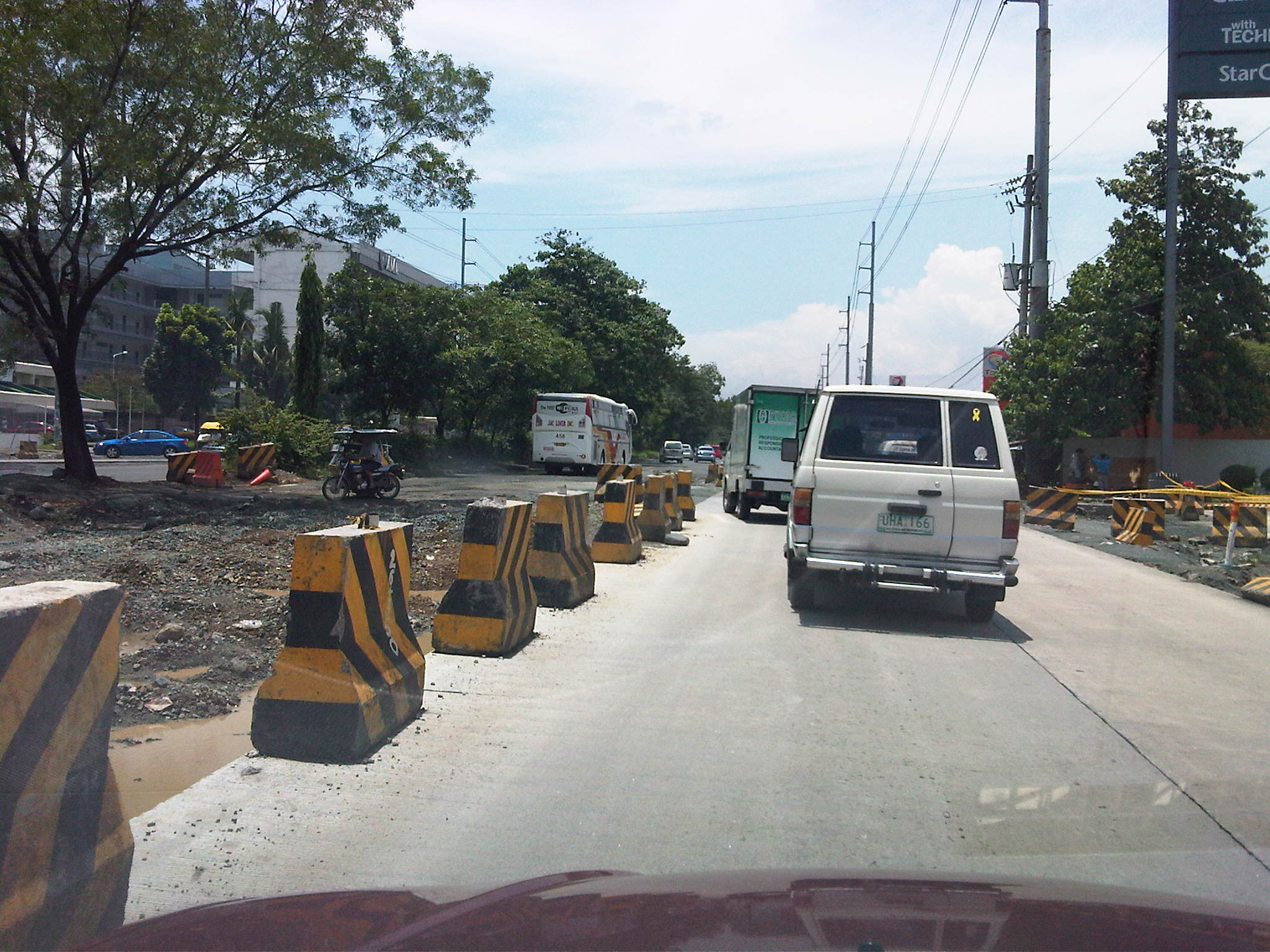 Unfinished drainage and roadworks along Marcos Highway westbound across the Caltex service station approaching the Filinvest East and Vermont Park gates – the section widens just before the subdivision gates and median opening but the inner lanes have not been paved at the time the photo was taken.
 Median opening (U-turn slot) for westbound traffic coming from Imelda Avenue – the old median opening across Burger King was closed and traffic was diverted to this slot located between the Shell and Phoenix service stations right after the Town & Country gate and CVC grocery. The result was less congestion due to weaving traffic between Imelda and this slot. This, however, came with a price – a longer trip for vehicles coming from Imelda Avenue.
With the completion of road and drainage works along Marcos Highway, it is expected that congestion will eventually be eased and the inherent costs will be reduced. Perhaps there will also be an opportunity to revisit traffic management and traffic control at critical junctions including Masinag, Imelda Ave./A. Tuazon, and A. Rodriguez/J.P. Rizal. So far, the perception of continuous movement due to the U-turn schemes along Marcos Highway have resulted in many adjustments to the locations of the slots while only producing congestion and perhaps encouraging aggressive driving behavior. Traffic signals should again be considered though traffic and travel behavior will surely be affected by a proposed extension of LRT Line 2.
Bottlenecks along Marcos Highway
Motorists and commuters using Marcos Highway which connects towns in the Province of Rizal to Metro Manila (particularly Marikina, Pasig and Quezon City) typically experience severe congestion due to two bottlenecks. These are at Santolan in the general area of the LRT 2 Station and near the junction with Evangelista Street, and at Ligaya near the junction with Amang Rodriguez/J.P. Rizal Avenues (note that the road intersecting with Marcos Highway is known as Amang Rodriguez on the Pasig side and J.P. Rizal in Marikina). Even without the current road and drainage projects being implemented on both sides of the highway, severe congestion is experienced in these areas.
There are mainly two reasons for congestion. The first is the operation of public utility vehicles, particularly jeepneys, in these areas. The second is the traffic flow characteristics, particularly merging and weaving activities, along Marcos Highway. Undisciplined operations of jeepneys in both areas have always led to congestion as they have tended to occupy significant road space (say 2 or 3 lanes) as they compete among themselves for space and for passengers. This generally results in the reduction of road capacity as there are less lanes available for all other vehicles traversing the highway. Chaotic loading and unloading have also influenced commuters to also compete for their rides with people often found advancing to meet up with the approaching jeepneys, and occupying road space in the process.
In the case of Santolan, people occupy 2 lanes just after the junction with Evangelista street right after the bridge. Such results in usually 2 to 3 lanes available to motor vehicles. Combined with jeepneys stopped across the LRT2 station, only 2 to 3 lanes are effectively available to traffic along a stretch of the highway. I always wonder why the MMDA and Pasig City enforcers are always appear to be helpless against these people when the former should be preventing the latter from occupying road space and causing congestion that can reach as far as Aurora Boulevard along and also fill up the bridge from C5. The situation is very similar for Ligaya where Pasig-Marikina jeepneys tend to establish informal, on-road terminals at the intersection itself and clogging both sides of Marcos Highway. Again, people are everywhere and occupy road space, ensuring that only a couple of lanes are usable for general through traffic. Here also, there seems to be enough enforcers from the MMDA and Pasig City but I always observe them not doing their jobs of managing the traffic and preventing mayhem in the area.
From the perspective of traffic flow, these two areas also have weaknesses. Santolan is already located in the vicinity of an LRT2 station so it is a natural stop for both public and private vehicles. Complicating its situation is the fact that for the eastbound side of the highway, two major streams merge. One comes from the highway bridge fed by both Aurora Boulevard and Maj. Dizon (Industrial Valley), and another comes the Macapagal Bridge that connects to C5. Since the general direction of most vehicles are towards Rizal, there is tremendous weaving activity in the area causing much friction among motor vehicles. On the westbound side of Marcos Highway, there is the tendency for divergence of traffic flow again due to the two bridges plus the presence of an SM Mall whose access road is to the right of the ramp leading to Macapagal Bridge. Again there is weaving activity here that has caused not a few road crashes.
The Ligaya junction used to be a signalized intersection that was closed and replaced by a pair of U-turn slots sometime during the past dispensation at MMDA. Thus, vehicles that used to go through Rodriguez/J.P. Rizal are now required to take a right turn and weave towards the U-turn slots a few meters downstream and weave again to take a right to Rodriguez or J.P. Rizal. Many of these are public utility jeepneys, the same ones that have informal terminals at the intersection itself. Vehicles negotiating the U-turn slots tend to block through traffic as they maneuver towards the outer lanes of the highway and head for the intersection, resulting in daily congestion at the already widened section of the highway in the vicinity of the U-turn slots. The morning case is usually the more severe one and there are usually no traffic enforcers in the area between 5:30 and 6:30 AM. If there happens to be a few early birds from the MMDA and Pasig, these seem to be more concerned with setting up the barriers for the counterflow scheme they implement in relation to the road and drainage project along the highway. Pasig enforcers do not manage the traffic but seem to be engrossed in apprehending those violating the number coding scheme. During the evenings, they are unmindful of the congestion and the people spilled out and occupying the traffic lanes seemingly content on watching vehicles crawling by.
These bottlenecks along Marcos Highway are examples of situations where simple traffic management in the form of active enforcement would be enough to alleviate congestion and perhaps help reduce the potential for road crashes (that may also result in more congestion). The enforcers’ presence and absence in these cases seem to add insult to the injury that is already caused by congestion that can be solved if the enforcers were doing their jobs in the first place. I would not even consider the relocation of the U-turn slots or the criticize the flaws of the design of the bridges’ ramps because the weaving behavior of vehicles may be effectively addressed by proper traffic management. And there are many similar cases throughout Metro Manila and other Philippine cities where this is happening. Hopefully, the agencies or local governments can address such concerns and with urgency considering the time and fuel wasted due to such bottlenecks.
Buses tagged…now what?
The MMDA issued a memo requiring all Metro Manila buses to paint their license plates at strategic areas of the bus exterior. These include standard sizes for “tags” to be placed on the roof, front, sides and back of the bus that are supposed to clearly show consistency with the license plate. Needless to say, if the license plate and the painted tags do not match, then the bus will be labeled colorum or illegally operating. Tags are also colored according to the general routes of the buses, with the yellow background applicable to buses plying routes along EDSA while an orange background applies to non-EDSA routes like those along Ortigas Ave. and Quezon Ave.
The tagging seems to be the latest in a long list of schemes that have been implemented to address the issue of colorum public transportation. While this is generally a matter for the LTFRB, the agency with the mandate to regulate road public transportation, the enforcement aspect is really quite demanding for an agency with few personnel to do this. As such, the LTFRB is usually assisted by other agencies like the MMDA or local government units. Franchise enforcement, however, is generally not the province of the MMDA or LGUs unlike their being deputized by the LTO in enforcing traffic rules and regulations (thus allowing the MMDA and LGUs to issue traffic tickets). The deputized MMDA and LGU enforcers may apprehend public utility vehicle drivers for traffic violations and in an ideal set-up, such violations should be considered when evaluating franchises for renewals. The propensity for violating traffic rules and regulations is a manifestation of poor driving habits and unsafe behavior on the road. Again ideally, such should be taken against operators who have the responsibility for hiring and training their staff. Operators should be held accountable should there be a high incidence of traffic violations and especially when there are incidences of crashes.
I am curious as to how the MMDA will be taking advantage of the bus tags in managing not only public transport but overall traffic as well. The tags present an opportunity where data collection may be facilitated and for various purposes. Such include a variation of the license plate surveys that are usually conducted to trace the movement of vehicles and determine whether they are speeding or travelling too slowly. An application of the outcomes of such surveys is the estimation of travel time along particular routes. For enforcement purposes, one can determine the reasonable turnaround time for public transport vehicles and allow for the checking of trip-cutting and the verification of the incidence of multiple plates. With the video cameras located at strategic points along Metro Manila’s major thoroughfares, sophisticated software employing image processing may be able to expedite the process, an example of an intelligent transport systems (ITS) as applied to public transportation.
The MMDA could even go further by consolidating travel time/speed data from public transport vehicles in order to derive real-time road network statistics. These could easily be visualized using digital maps that can be made online and shared to motorists and commuters alike to allow for better travel planning around the metropolis. Travel time/speed data have been used by researchers and agencies in other countries to estimate road traffic performance throughout the day and may be employed in modeling traffic in order to predict travel characteristics given typical factors affecting the traffic stream. Private vehicle characteristics are approximated by taxis that operate pretty much like private vehicles given that they do not have fixed routes and are not confined to lanes normally assigned to buses and jeepneys.
Such a comprehensive and sophisticated system for traffic management would require that all public transport vehicles be tagged including jeepneys and taxis. This also requires both hardware and software, and most importantly, capacity and on the part of Perhaps this is an alternative to requiring all to have GPS or RFID installed. Of course, the latter devices have more applications due to their potential for data storage (e.g., vehicle registration, franchise, location, etc.) but unfortunately, there are issues that still need to be addressed and questions left unanswered that are associated with these devices. Sayang! But even so, the bus tags (and maybe jeepney and taxi tags in the future) already present a lot of opportunities for monitoring, evaluation and improvement of traffic in Metro Manila. If only such potential can be realized and maximized by the MMDA and other agencies…
Still on Katipunan
Katipunan is again the subject of attention thanks to the Sunday newspaper article by Prof. Randy David in his column at the Inquirer. The problem is not really new and I have been familiar with the congestion and its derivatives from the time I first studied in UP Diliman in 1988 and up to now when I continue to pass through the avenue between home and workplace.
I was able to dig up a 2003 study on Katipunan conducted by the National Center for Transportation Studies (NCTS) of UP for a consortium chaired by then DENR Secretary Bebet Gozun. The study was the group’s response to the MMDA’s effort to install their U-turn scheme along Katipunan, encouraged at the time by the scheme’s apparent success along Commonwealth and EDSA while not acknowledging the problems experienced along Quezon Avenue. The photos below were taken during the time when the study was being undertaken and are very much the same picture of Katipunan today during the peak periods.
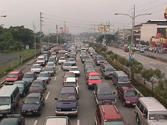 Figure 1: Morning traffic congestion in 2003 along the northbound direction of Katipunan Avenue in front of the Ateneo De Manila University (notice that there was no U-turn slot near Gate 2 at the time)
 Figure 2: Ateneo-bound vehicles blocking through traffic along the service road and the Aurora flyover
The study involved contributions from most if not all stakeholders including Ateneo and Miriam, the private sector and civil society groups, the Transportation Science Society of the Philippines (TSSP), and some government agencies particularly the DENR, who convened the group to formulate an alternative to the MMDA’s initiative that was personally being pushed by its then Chair Bayani Fernando. I reproduce below, word for word, the conclusions and recommendations from that 2003 study:
{Conclusion}
“After a thorough evaluation of the traffic problems along Katipunan as well as the solicited and unsolicited solutions from stakeholders, it becomes clear that the answer to the Katipunan traffic question is not the introduction of the U-turn scheme into the system. Indeed, while the U-turn scheme has met with relative success along major thoroughfares including Marcos Highway and Commonwealth Avenue, it has also contributed if not created congestion along Quezon Avenue. The notion that “success in EDSA and Commonwealth means there is no reason why the scheme won’t work in Katipunan” would not hold water in the light of the requirements for effective implementation of U-turns. Simply said, the traffic volume along Katipunan during the peak periods alone will assure that the U-turn scheme will cause more congestion rather than mitigate it.
{Recommendations}
- Optimization of traffic signals – coordination of signals need to be implemented particularly for the intersection pairs identified in this report. The Traffic Engineering Center (TEC) must be consulted with respect to the operation of the traffic signals along Katipunan.
- Restriction of roadside parking – parking restrictions must be strictly enforced and establishments along Katipunan should adhere to the required parking slots corresponding to the traffic they generate.
- Removal of parts of the islands to improve flow – geometric improvements to ease flow (i.e., increase road capacity) may be explored. Note that this report is not entirely opposed to removal of parts of the islands. However, their outright removal with the trees for the sole purpose of the U-turn scheme is not acceptable to most stakeholders. This must be carefully evaluated.
- Construction of an internal road between Ateneo and Miriam – the internal road will allow common vehicles to circulate within the campuses thereby eliminating traffic that would otherwise make several entries and exits to the campuses via Katipunan.
- Open additional gate at Ateneo – the possibility of opening another gate at Ateneo between the existing Gates 2 and 3 must be explored.
- Encourage carpooling or car-sharing – it is strongly recommended that Ateneo and Miriam consider carpooling or car-sharing schemes. It has been found that traffic along Katipunan is primarily composed of private vehicles will low occupancies bound for the two schools. While the surveys showed high return rates from grade school and high school students, very low returns came from college students. It is these people who account for a majority of the vehicles that clog Katipunan and they should take part in the formulation and implementation of such schemes that would lead to a significant improvement to traffic along Katipunan.
- Strict implementation of the zoning laws – this last recommendation points to the inconsistency in the granting of building permits to developers of high-rise condominiums along Katipunan. This is a constant issue and a controversial one since residents in the area and the two major schools (Ateneo and Miriam) have always opposed the “spot zoning” practice along Katipunan.” (NCTS, Study on the Traffic Management of Katipunan Avenue, 2003)
The study recommended alternative solutions in lieu of the U-turn scheme for Katipunan Avenue that was at the time being pushed by the MMDA as the solution for traffic congestion in the area. The recommended measures considered different aspects: traffic management per se, geometric improvements or road construction, travel demand management, land use, and other measures. However, it seems that 8 years after there has been practically no change in conditions along Katipunan Avenue.
The support and commitments of the different stakeholders (academic institutions, residents, business establishments, professional organizations, government agencies, and concerned citizens) are essential for the successful implementation of the recommendations contained herein. It is only through a strong partnership that sustainable and long-term solutions to the traffic problems in Katipunan Avenue can be achieved.
However, it is realized that there should be some sacrifices involved including a dramatic or drastic change in the travel behavior of those mainly responsible for the congestion. The vehicle trip generation of both Ateneo and Miriam are the roots of the problem and their continuing resistance to proposed solutions while not offering any viable countermeasures or proposals will only serve to perpetuate congestion in the area even as the external costs associated with the traffic they generate spread to a larger area. Recent studies at the UP Diliman, which is an open campus, has shown that private vehicle through traffic (i.e., traffic that has nothing to do with UP) has also grown and most of these are Ateneo and Miriam-bound trips.
It seems awkward and even confusing to see that 8 years after what was perhaps the last (maybe even the first?) serious look into Katipunan traffic, conditions have only worsened. This is due to additional developments in the area including high density residential projects that also tend to generate a lot of traffic, and commercial establishments that do not provide sufficient parking spaces. But although these contribute to congestion, their vehicle generation pale in comparison to that of the schools in the area. This is perhaps a case where one is able to see the flaws of others and yet refuses to look in the mirror to see for oneself something that needs critical attention.
Countdown
Among the things you get to observe at signalized intersections are the behavior of drivers given the setting of the traffic lights. While the cyclic transition from red to green to amber and then to red again seems routine and possibly trivial to many, it is an opportunity for traffic engineers to examine how drivers react to the lights. Among the most notable behavior are common violations like beating the red light and occupying the area within the yellow box despite full awareness that the exit is already full.
Then there are the not so obvious but risky habit of some drivers to beat the green light. That’s when a driver anticipates the green light and proceeds to move prior to the signal and before the intersection is clear of any vehicles or pedestrians that may have been caught in the change in signals. It is a practice that increases the probability of a road crash occurring as the clearance interval for vehicles whose paths may be in conflict is drastically reduced. This is a habit of many drivers who are familiar with the sequence of signals at an intersection and who know when its their turn for the green light.
In most cases, drivers and pedestrians are unaware of the length of time available for them to cross the street or intersection. There are no indications for when the lights will change and only familiarity would allow for drivers or pedestrians to estimate when it would be their turn to proceed. In Japan, many intersections play music during that tends to speed up when the signal will be changing. This audible indicator allows for both the blind and the busy to know whether it is safe to cross the street and if there is enough time to do so. It is also something that is probably taught to children for them to more easily know when it is safe for them to cross the street.
There is another innovation to traffic signals that is surely welcome to pedestrians and motorists alike but which may also have its disadvantages. I am referring to the countdown timer, which provides road users the information about the lengths of green and red signals (Note: Amber or yellow is usually fixed at 3 seconds.). From the perspective of energy efficiency, such information may allow motorists to turn off their engines, usually done when one practices eco-driving, resulting in fuel savings. Meanwhile, drivers of vehicles approaching an intersection may be able to tell if there is enough time for them to do so, and if there isn’t enough time they may be able to slow down their vehicles to stop at the next red light. Countdown timers may also be a helpful tool for enforcement as the timers establish that a driver should be aware of the time. Thus, a driver can no longer reason with the apprehending officer that he/she was not aware of the remaining time for movement.
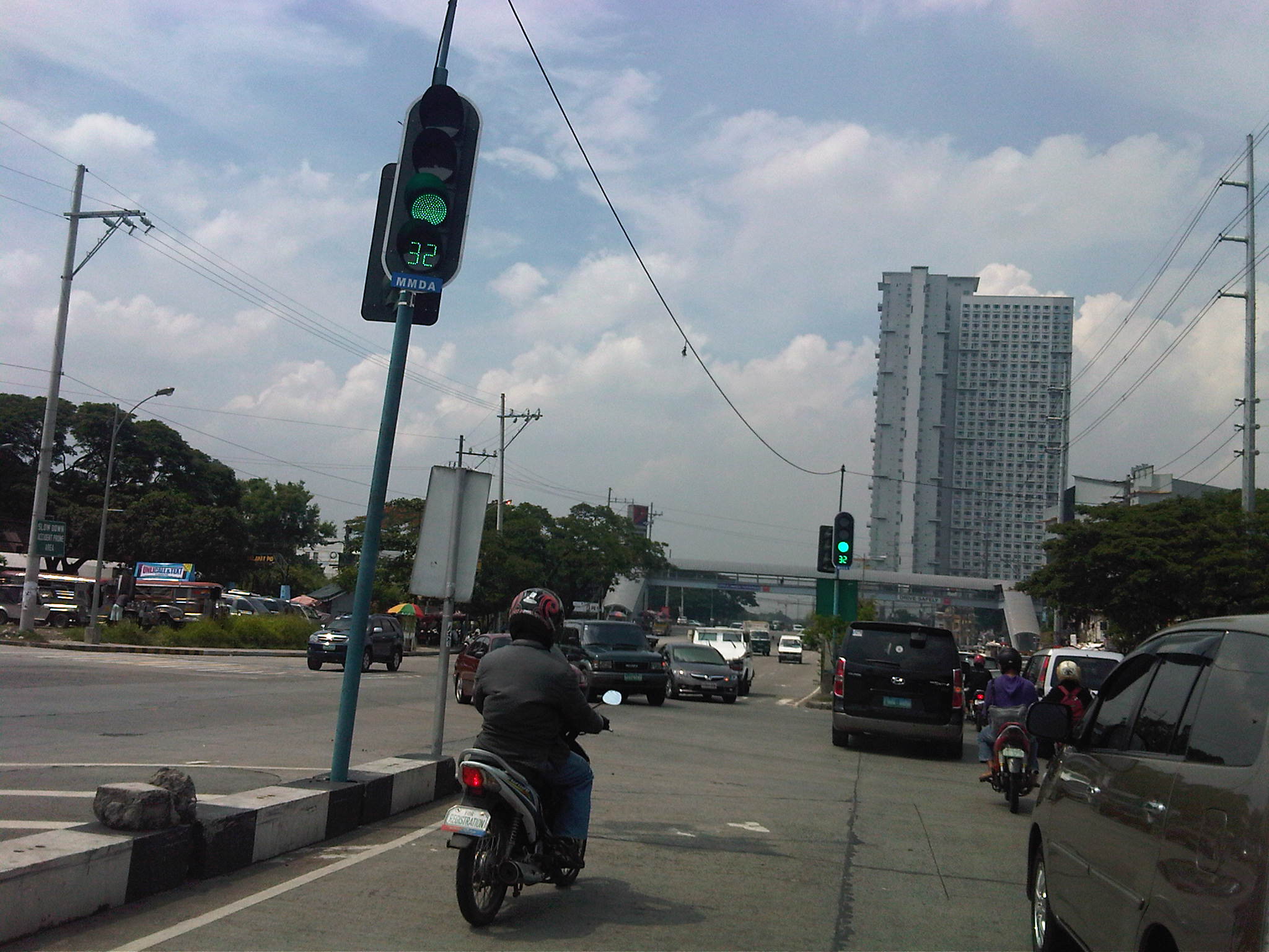
Pedestrians may also benefit from the knowledge of available time to make a safe crossing. This information should ultimately reduce the need for running in order to completely cross the street. The photo below shows the new countdown timer installed for the southbound through movement at the Katipunan Avenue (C5) – C.P. Garcia Avenue intersection.
One possible disadvantage would be that aggressive drivers may still try to beat the red light by speeding up upon knowing what amount of time is available for them. Another disadvantage relates to beating the green light as even those unfamiliar with the signal sequence will have the information of how much time remains before they can proceed. Thus, many driver and riders start revving up their engines and push on their gears to anticipate the green signal. You can even imagine the countdown timer being used as if it were ticking towards to start of a race.
Despite the disadvantages mentioned, countdown timers should prove to be more beneficial than detrimental in most situations. In fact, countdown timers like the ones already installed at intersections in Bonifacio Global City should enhance traffic safety provided that these devices are fully complemented by enforcers who would flag down motorists and pedestrians who would attempt risky actions in relation to the timing device. Of course, from the research perspective there needs to be a scientific assessment of the actual impacts of countdown timers much like the studies already conducted elsewhere to determine and even measure the effects of these devices on both motorists and pedestrians. Only then can we truly say if they do enhance safety and promote more efficient operations at a signalized intersection.
Enforceable?
Whenever laws and regulations are crafted, one basic question that needs to be considered pertains to whether there is capacity to enforce such laws or regulations. This is quite logical and appeals to common sense since laws and regulations are practically prints on paper that will not have any impacts if not enforced properly and fairly. I mention “fairly” here because laws and regulation may also be the subject of abusive enforcement. That is, there have been cases where motorists are flagged down and charged with violations that are taken out of the context given the traffic conditions, and where the number of apprehensions are related to quotas set by authorities.
Take the case of the unwarranted or illegal use of sirens (wangwang) in the past. There were laws and regulations for its use but for a long time these laws and regulations were not enforced properly, leading to the wangwang’s abuse by many unscrupulous people. Almost everyone have practically given up on this abuse of the siren when a newly elected President expressed his dismay and ordered the eradication of illegal sirens. Almost overnight, “wangwangs” were confiscated by authorities inspired by the Commander-in-Chief’s orders or removed by owners themselves for fear of the law bearing down on them. This was enforcement at its best. Unfortunately, it was not replicated for other traffic laws and regulations, wasting valuable momentum and the opportunity to make things right along our streets and highways.
Quezon City’s Green Building Ordinance is quite good and well-meaning. It is very timely and relevant, and even includes provisions for upgrading transport in that city. Among others, it requires that tricycles be transformed into cleaner vehicles by stipulating the replacement of 2-stroke and even 4-stroke motorcycles with LPG or electric models. To date, nothing significant has been achieved to address issues pertaining to the tens of thousands of tricycles in Quezon City. The construction of green buildings in Quezon City cannot be mainly attributed to the ordinance but rather to owners and designers who are now much more aware of climate change and its impacts, and are progressive enough to design buildings that are environment-friendly. Of course, there are those who take to the “green” bandwagon but do nothing towards this end. Are these subject to evaluations and inspections that are the equivalent of enforcement?
Now comes a bicycle ordinance from Pasig City that is formally the “Bicycle Transportation Promotion Ordinance of 2011.” It is also good and well-meaning but the jury will definitely be out there if this initiative will be a successful and sustainable one. I am quite hopeful that it would be and not just end up as an example of coming up with laws because anything about the environment is in these days. The provision in the ordinance designating bicycle lanes and requiring establishments to provide bicycle racks for parking are all good but we have seen this before in an even bigger scale in the City of Marikina. There they constructed bikeways practically connecting all parts of the city and they were quite aggressive even after foreign support had ended. Politics and shortcomings (I wouldn’t say failure.) in encouraging people to cycle have made much of the on-street bicycle lanes practically taken over by motorized transport. Bicycle racks there are also being used by motorcycles and scooters. Pasig should learn from these experiences and it is hoped that the city succeed and become another example of EST to be replicated in other Philippine cities.
School traffic generation – Part 1
One thing I will miss about summers is the relatively light traffic along Katipunan Avenue, which is where I pass through almost everyday between my home and workplace. There is still some congestion during the mid-day and the afternoons but these are typically due to truck traffic as Circumferential Road 5 (C5) is a truck route. During the rest of the year, however, with the exception of most weekends and holidays, severe congestion is experienced along Katipunan during the peak periods, particularly in the mornings between 6:30 AM and 7:30 AM. This is due primarily to the traffic generated by schools along Katipunan Avenue, most notably the Ateneo De Manila University and Miriam College. The following photos show typical traffic conditions along C5 during the peak periods.
 Slow-moving vehicles along the northbound side of Katipunan Avenue
 Congestion along the northbound direction of Katipunan atop the Aurora Blvd. overpass
 Congestion along the Katipunan southbound service road leading to the U-turn slot underneath the Aurora Blvd. overpass
Traffic along the southbound service road leads to a U-turn slot under the overpass where many vehicles turn, heading in the general direction of Ateneo. Most turn here in order to enter the university via its Gate 1, which is the main access to the Grade School. On most times, congestion is caused by these vehicles turning right at Gate 1 as they effectively occupy the two lanes of the northbound service road and block all other traffic. This is shown in the following photo where it is clear that vehicles bound for Ateneo and turning at Gate 1 are the main cause of congestion. Beyond Gate 1, the traffic lanes are practically free of congestion.
 Vehicles turning right to Ateneo’s Gate 1 blocking traffic along the Katipunan northbound service road
The afternoon peak is exacerbated by traffic generated by these schools that lead to longer periods of congestion as the number of private vehicle traffic dramatically increases when there are classes between June and April. Meanwhile, there is a noticeable decrease in traffic during the weekends and holidays. Such phenomenon is mostly attributable to the trip generation characteristics of schools, and especially those that tend towards the generation of much private vehicles. Ateneo and Miriam along Katipunan are just two examples. The traffic they generate and the consequential congestion is replicated in other places as well, giving headaches to motorists and commuters passing along major roads affected by these schools. Ortigas Avenue, for example, is usually congested during the weekdays because of traffic generated by LaSalle Greenhills, and ADB Avenue at the Ortigas Center is usually congested due to traffic attributed to Poveda.
Traffic Congestion in Metro Manila: Is the UVVRP Still Effective? -Conclusion
The MMDA always reports what it claims as improvements of travel speeds along EDSA that past years. They have pointed to this as evidence that traffic congestion is being addressed and that programs like the UVVRP are effective in curbing congestion. However, many traffic experts have cautioned against making sweeping generalizations pertaining to the effectiveness of schemes especially if the evidence put forward is limited and where data seems to have been collected under undesirable (read: unscientific) circumstances.
The MMDA also has been using and to some extent overextending its use of a micro-simulation software that is employs to demonstrate the potential effectiveness of its proposed traffic schemes. The software has an excellent animation feature that can make the untrained eye believe in what is being shown as The problem here is when one realizes that computer software will only show what the programmer/operator wants, and is perhaps an example where the term “garbage in, garbage out” is very much applicable. And this is especially true should the computer model be uncalibrated and unvalidated according to guidelines that are well established, and extensively discussed and deliberated in a wealth of academic references. The fallacy of employing advanced tools to demonstrate how one’s proposal is better than another was highlighted when the DPWH acquired the same tool and came up with an entirely different result for an analysis being made for the same project by that agency and the MMDA. Surely this resulted in confusion as the outcomes of the simulation efforts of both agencies practically negated each other.
It should be pointed out that such micro-simulation software is unsuitable for the task of determining whether metro-wide schemes such as the UVVRP is still effective given the actions of those affected by the scheme. What is required is a macroscopic model that would take into account the travel characteristics of populations in Metro Manila and its surrounding areas (cities and towns in the provinces of Rizal, Bulacan, Cavite, Laguna). There are quite a few of these models available but most if not all were derived from the one developed under the Metro Manila Urban Transport Integration Study (MMUTIS) that was completed in 1999. The main beneficiary from the outcomes of MMUTIS happens to be the MMDA but for some reason, that agency failed to build capacity for maintaining and updating/upgrading the model. As such, the agency missed a great opportunity to invest in something that they could have used to develop and evaluate traffic schemes to address congestion and other traffic issues in Metro Manila, as well as to assess the impacts of new developments.
Metro Manila has come to a point where its options for alleviating congestion are becoming more and more limited. The combination of a still increasing rate of motorization and private vehicle use have definitely contributed to congestion while there are also perceptions of a decline in public transport use in the metropolis. The share of public transport users in most Philippine cities and municipalities range from 80 – 90 %, while in many highly urbanized cities the tendency seems to be a decline for this share as more people are choosing to purchase motorcycles to enhance their mobility and as a substitute to cars. This trend towards motorcycle use cannot be denied based on the steep increase in ownership and the sheer number of motorcycles we observe in traffic everyday.
Metro Manila needs to retain the substantial public transport share while accepting that motorcycle ownership will continue to chip off commuters. The latter phenomenon can be slowed down should authorities strictly enforce traffic rules and regulations on motorcyclists, effectively erasing the notion that the latter group is “exempted” from such. The bigger and more urgent issue is how to put up long overdue mass transport infrastructure that is direly needed in order to create another opportunity for rationalization transport services. We seem to like that word “rationalization” without really understanding and acting on what is required to once and for all address transport problems in the metropolis. We are not lacking for examples of good practices that are both effective and sustainable including those in the capital cities of our ASEAN neighbors. However, we seem to be unable to deliver on the infrastructure part that we have tended to over-rely on a TDM scheme that has long lost much of its effectiveness. The evidence is quite strong for this conclusion and perhaps we should stop being in denial in as far as the UVVRP’s effectiveness is concerned. Efforts should be turned towards building the necessary infrastructure and making public transport attractive so that private car and motorcycle users will be left with no excuse to shift to public transport use. It is inevitable that at some time they will understand the cost of congestion and that they will have to pay for their part in congestion like what is being done along tollways or, in the more sophisticated and mature example, Singapore. But this cannot be realized if we continue to fail in putting up the infrastructure Metro Manila so direly requires.
Traffic congestion in Metro Manila: Is the UVVRP still effective? – Part 2
In the past decade, there has been a sharp rise in the motorcycle ownership around the country and especially in Metro Manila. From about 1 million motorcycles registered in 2000, the number has increased to 3.2 million in 2009, a 320% increase over a period of 10 years. Motorcycles have become associated with mobility, in this case the motorized kind, and have become the mode of choice for many who choose to have their own vehicles but cannot afford a four-wheeler. These people also choose not to take public transport for a variety of reasons but mainly as they perceive their mobility to be limited should they use public transport services that are available to them. This rise of the motorcycle is also a response to the restrictions brought about by UVVRP with the scheme not covering motorcycles. In fact, should motorcycles be included in the UVVRP, it would be a nightmare for traffic enforcers to apprehend riders considering how they maneuver in traffic. Add to this the perception and attitude of riders that motorcycles are practically exempt from traffic rules and regulations (and traffic schemes!). One only needs to observe their behavior to validate the argument.
To understand UVVRP, it must also be assessed in the context of its original implementation when Metro Manila had to contend with congestion due to infrastructure projects being constructed everywhere during the 1990’s. EDSA MRT was being constructed, interchanges were also being put up, and a number of bridges were being widened to accommodate the increasing travel demand. Road widening projects generally benefit private vehicle users more than public transport users. In the case of Metro Manila, many areas are already built-up and acquisition of right of way for widening is quite difficult for existing roads. As such, it is very difficult to increase road capacities to accommodate the steady increase in the number of vehicles.
In transportation engineering, when traffic/transport systems management (TEM) techniques are no longer effective or yield marginal improvements we turn to travel demand management (TDM) schemes to alleviate congestion. In the former, we try to address congestion by tweaking the system (i.e., infrastructure) through road widening, adjustment of traffic signal settings, etc. while in the latter, we go to the root of the problem and try to manage the trips emanating from the trip generation characteristics of various land uses interacting with each other. By addressing the trip generation characteristics through restrictions, we influence travel demand and hopefully lessen traffic during the peak periods while distributing these to others.
This is the essence of UVVRP where the coding scheme targets particular groups of private cars (according to the end number on the license plate) each weekday. Meanwhile, the scheme is not implemented during weekends due to the perception that, perhaps, travel demand is less or more spread out during Saturdays and Sundays. However, there is a problem with this approach as the traffic taken away from the peak hours are transferred to other times of the day, thereby causing in some cases the extension of what was originally a peak hour unto a longer period. What was before a morning peak of say 7:30 – 8:30 AM becomes spread out into a peak period of 7:00 – 9:00 AM. The problem here is when you have major traffic generators like central business districts (e.g., Makati and Ortigas) where congestion is experience for more than 2 hours (e.g., 7:00 – 10:00 AM or 4:00 – 7:00 PM).
The UVVRP is not implemented in all of Metro Manila. Several LGUs, particularly those in the outer areas like Marikina City and Pateros. This is simply due to the information and observations of these cities that their roads are not affected by the build-up of traffic since most traffic is bound for the CBDs located in Makati, Pasig, Mandaluyong, Quezon City and Manila. This is the case also for LGUs in the periphery of Metro Manila like the towns in the province of Rizal, which is to the east of the metropolis, where the typical behavior of traffic is outbound in the morning and inbound in the afternoon. The great disparity between inbound and outbound traffic is evident in the traffic along Ortigas Avenue where authorities have even implemented a counterflow scheme to increase westbound road capacity.
There have also been observations of traffic easing up during the mid-day. As such, the MMDA introduced a window from 10:00 AM to 3:00 PM to allow all vehicles to travel during that period while retaining the restrictions of the number coding scheme from 7:00 – 10:00 AM and 3:00 – 7:00 PM. However, while many LGUs applied the window, some and particularly those found in central part of the Metropolis like Makati, retained the 7:00 AM – 7:00 PM ban. This stems from their perspective that traffic does not ease up at all (e.g., try driving along Gil Puyat Ave. during lunchtime) along their streets during the window period.
Nowadays, there seems to be the general perception that one can no longer distinguish between traffic during the coding period and the window. Traffic congestion is everywhere and there are few opportunities for road widening. Traffic signal control adjustments are limited to those intersections where signals have been retained (mostly in Makati) since the MMDA replaced signalized intersections with U-turn slots during a past administration where the U-turn was hailed as the solution to the traffic mess.
Traffic congestion in Metro Manila: Is the UVVRP still effective? – Part 1
I was interviewed last week about the traffic congestion generally experienced along major roads in Metro Manila. I was asked whether I thought the Unified Vehicular Volume Reduction Program (UVVRP) more popularly known as the number coding scheme was still effective, and I replied that based on what we are experiencing it is obviously not effective anymore. The reasoning here can be traced from the fact that when the scheme was first formulated and implemented, the main assumption was that if the number of license plates on registered vehicles were equally distributed among the 10 digits (1 to 0), then by restricting 2 digits indicated as the end/last number on a plate we could automatically have a 20% reduction in the number vehicles. This rather simplistic assumption was sound at the time but apparently did not take into consideration that eventually, people owning vehicles will be able to adjust to the scheme one way or another.
One way to adjust when the number coding scheme was implemented was to change traveling times. Everyone knew that the scheme was enforced from 7:00 AM to 7:00 PM (i.e., there was no 10:00 AM to 3:00 PM window at the time) and so people only had to travel from the origins to their destinations before 7:00 AM. Similarly, they would travel back after 7:00 PM, which partly explains why after 7:00 PM there is usually traffic congestion due to “coding” vehicles coming out to travel. In effect, the “coding” vehicle is not absent from the streets that day. Instead, it is only used during the time outside of the “coding” or restricted period.
Another way that was actually a desired impact of the coding scheme was for people to shift to public transport, at least for the day when their vehicle was “coding.” That way, the vehicle is left at home and there is one less vehicle for every person who opted to take public transport. This, however, was not to be and people did not shift to public transport. Perhaps the quality of services available or provided to them were just not acceptable to most people and so they didn’t take public transport and a significant number instead opted for a third way.
That third way to adjust was one that was the least desirable of the consequences of number coding – people who could afford it bought another vehicle. This was actually a result that could have been expected or foreseen given the trends and direct relationship between increases in income associated with economic growth where people would eventually be able to afford to buy a vehicle. Actually, there is no problem with owning a car. The concern is when one uses it and when he opts to travel. Of course, this does not necessarily mean that people started buying new cars outright, making this something like an overnight phenomenon. It happened over several years and involved a cycle that starts when the wealthier people decide to purchase a new vehicle and discards their old ones. These used vehicles become available on the “second hand” market and are purchased by those with smaller budgets. Some of these may have even older vehicles that they will in turn discard, and eventually be owned by other people with even less budget. Note that in this cycle, very few vehicles are actually retired, if at all considering this country has no retirement policy for old vehicles. The end result? More cars on the roads and consequently, more severe and more frequent congestion.
Below is an excerpt from the news report on News TV Channel 11:
 Caught (up) in traffic