
Home » Transport Planning (Page 11)
Category Archives: Transport Planning
References for improvements for active transportation
Here’s a nice link to a National Academies of Science, Engineering and Medicine pointing to the wealth of researches supporting improvements for active transportation:
Paths to Biking, Walking Improvements Supported by Wealth of Research
Link: https://www.nationalacademies.org/trb/blog/paths-for-walking-and-biking
The references listed should aid researchers, practitioners, advocates and policymakers in their work towards realizing a people-oriented vs car-centric transportation.
–
On solving the inequality problem in cities
Here is another quick share of an article that is timely and relevant not just now but for years (maybe decades?) to come:
Grossman, D. (2020) “New Study Proposes a Mathematical Solution to Big Cities’ Inequality Problem,” Inverse, https://www.inverse.com/science/a-new-study-shows-why-building-more-equal-cities-could-save-lives?link_uid=15&utm_campaign=inverse-daily-2020-09-14&utm_medium=inverse&utm_source=newsletter [Last accessed: 9/15/2020]
I will just leave it here for future reference but to summarize, the article explains how cities should be planned or replanned based on the distribution or redistribution of certain facilities like hospitals, banks, schools, supermarkets, and parks. It argues that there is an optimum location for these in relation to where people live and work. If properly planned, travel distances and times can be significantly reduced.
–
The plight of commuters during GCQ
I write this on the eve of the imposition of Modified Enhanced Community Quarantine (MECQ). It is another unfinished article that was intended to be a quick post showing the typical conditions for commuters during the GCQ. Public transport supply was slow to return to adequate levels as the government took advantage of restrictions to impose route rationalization and modernization programs. The following scenes were common along my commuting routes:
 Commuters waiting for a ride near the provincial capitol
 The rains of the wet season added to the misery of the wait.
 Long queue at the public transport terminal at Robinsons Antipolo, which is the terminus for buses connecting Antipolo with Cubao and Ortigas Center.
 The queue reaches beyond the shaded areas of the terminal.
I think national government should be the one to provide for the public transport needs of frontliners (i.e., health care workers including doctor, nurses, medical technologists, pharmacists, etc.) and other essential workers. My definition of the latter are those required for logistics to function as well as those to ensure the required production or manufacturing for the rest of us who need to stay at home. Not everyone has the same, fair circumstances as there are those who can afford to stay at home and those who need to work for them to live, often on a day-to-day basis.
The pandemic has taken a toll not only on the physical but the mental health of many of us. Government rants and retorts are unnecessary and uncalled for given its dismal performance. I dare say dismal as the evidence shows certain local government units and the Office of the Vice President doing much, much more despite their limited resources. We are not in this quandary because government performed well and to the best of their people’s abilities. If that was their best then they have no business staying in their positions. If our health care system fails, then there is nothing to stop this pandemic from claiming much more than lives.
–
On mass transit and active transport
I recently gave a talk on transport in the new normal. There are a lot of materials that you can refer to if you want good visuals for a presentation. It helps to capture the attention and maybe the imagination of your audience, which in this case was varied. While I assume many to be in the physical, chemical & social sciences, and engineering, I knew that there were also people from media and those who were just interested in the topic. And so I made sure there were a lot of infographics mixed in with bullet points to drive the message clear about mass transit systems being the backbone of transport in highly urbanized cities, conventional transit like buses and jeepneys supplementing and complementing these, and active transport enabled and encouraged as a safe option for many.
I wasn’t able to include the following graphic shared by a friend advocating bicycle use especially for work and school trips. The following graphic comes from TUDelft, which is among the major universities in the forefront of research in transit and cycling. Clicking on the graphic will take you to their Facebook page and more links to their programs.
![]()
Note the essential information relating bicycles and transit in the graphic. Do we have similar data in the Philippines (or at least for the National Capital Region)? I hope this stirs interest for research work. There are a lot of topics to take on including even data collection to capture the information required for substantial studies on cycling, transit and their relationship.
–
Why cycling or bicycles are good for the economy?
You saw that meme shared in social media where they say “why bicycles are bad for the economy”? There’s some humor there but it doesn’t necessarily convince many people to support cycling or biking over motor vehicle use.
Here goes one and note the logic:
“Cycling or bicycles are good for the economy because…it helps reduce car use/dependence. That means less dependence and expenses to fossil fuels. That means more money available to the household for more important stuff like food, homes and education.”
Can you come up with something like that?
 Workers on bicycles crossing the Marcos Highway bridge from Marikina towards Quezon City.
–
On pandemic travel patterns and the future
Here is a recent article on travel patterns as influenced by the COVID-19 pandemic.
Bliss, L., Lin, J.C.F., and Patino, M. (2020) “Pandemic Travel Patterns Hint at Our Urban Future,” Bloomberg CityLab, https://www.bloomberg.com/graphics/2020-coronavirus-transportation-data-cities-traffic-mobility/?sref=ViNyghXi [Last accessed 6/19/2020].
Are these travel patterns similar to those of our cities and municipalities in the Philippines? Or were there a different reactions or outcomes considering local factors including perhaps cultural aspects?
–
Traffic is back to “normal”
Traveling to the office last Monday, I could not help but notice the long lines of cars along Ortigas Avenue’s westbound lanes and Katipunan’s southbound lanes. Without adequate public transportation, people have few options for their commutes. Walking from home to workplaces is feasible only for those who live relatively near their workplace (perhaps up to 5km distance?). Cycling may be considered but not everyone can bike beyond 5km, what more for 10km+ commutes. And for both cases, there are just so many obstacles (and I’m not just fault-finding here) like a lack of sidewalks and bike paths to ensure safe walking and cycling.
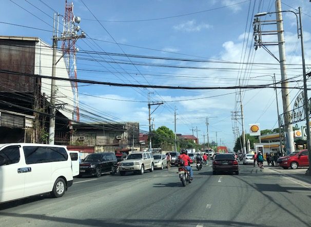 Traffic congestion along Felix Avenue in Cainta towards Cainta Junction (with Ortigas Avenue Extension) – these are mostly outbound traffic likely coming from the residential subdivisions along Felix Avenue and heading to workplaces in Pasig, Mandaluyong, Makati and Taguig. They will likely take Ortigas Avenue to connect with other major roads such as C-5 and EDSA to get to their destinations.
The DOTr and the LTFRB have released guidelines for safety and the prevention of the spread of the COVID-19 virus. Yet, they have moved quite so slowly to bring back public transportation to address the demand for it and to be able to discourage or restrict car usage in the “business-as-usual” or “old normal” sense. Public transportation is critical if we are to transform transportation during this transition from the lockdowns. Granted, the government probably wants to use the situation to effect its modernization plans but it is one thing to take advantage of the opportunity and another to be an opportunist considering the vulnerabilities of the transport sector after it endured 3 months of shutdown. The moral and right thing to do is to bring back public transport and give incentives for it to thrive and perhaps transform or upgrade by themselves rather than force the situation at the expense of commuters.
–
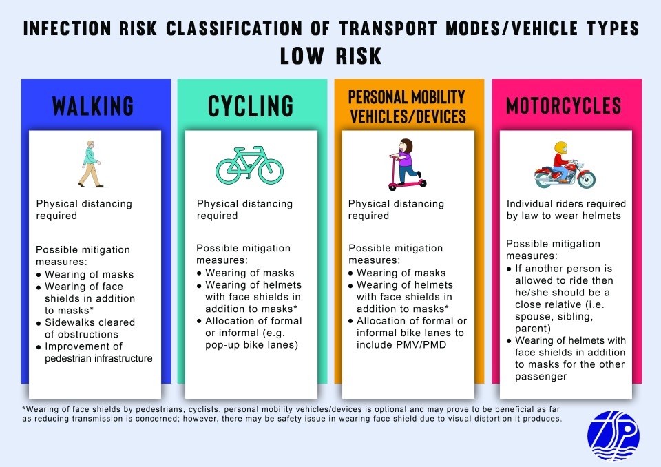
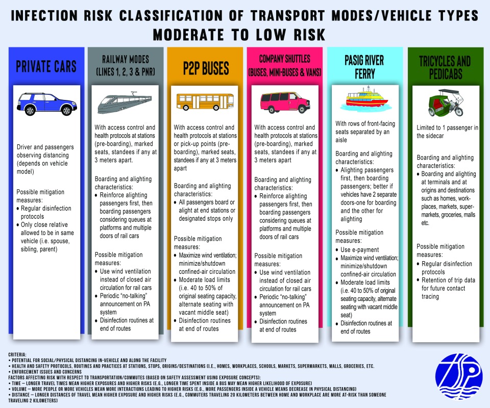
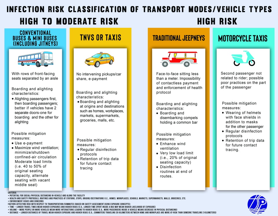
Infographics: Infection Risk Classification of Transport Modes Post-ECQ
The infection risk table I posted a few days ago was improved into the following infographics:
–
COVID-19 Infection Risk Assessment of Transport Modes
I posted about the work we have been doing to assess the infection risk (i.e., spread of COVID-19) for various modes of transport considering the transition of many areas including the National Capital Region (NCR) to the General Community Quarantine (GCQ). The work was undertaken through the Transportation Science Society of the Philippines (TSSP), which is under the umbrella of the Eastern Asia Society for Transportation Studies (EASTS). Here is the outcome in the form of an “Infection Risk Classification of Transport Modes or Vehicle Types” developed by a core group of public transportation and road safety specialists among its members:
![]()
![]()
![]()
![]()
Note again that this is the product of a rapid assessment using the mentioned criteria and factors. It is a qualitative assessment and a quantitative one, given the data, would obviously been preferred. Moreover, this is an assessment for risk of infection rather than for road safety. In the “old normal”, for example, cycling and motorcycle use may have a higher risk in traffic given traffic mix, human behavior and lack of facilities to make these modes safe.
–
Assessing the risk of infection from the transport safety perspective
My colleagues and I have been developing a risk assessment table for land transport modes to be submitted to the UP COVID-19 Response Team. We did a rapid assessment using mainly concepts from road safety.
The concepts are fairly simple. Risk assessment can be based on the likelihood of contracting the virus gauged from certain exposure factors. Exposure estimation may be quantitative where metrics are applied and data collected for the analysis. Estimation may alternatively qualitative based on experiences, perceptions, expert opinions, etc. but subject to logic (e.g., careful deduction). In road safety, for example, these factors may be defined as three: time, distance and volume.
Time exposure can be determined using travel time as a metric. Longer the travel times mean higher exposures for a commuter. Higher exposure translate to a higher likelihood that a person may become involved in a road crash. Thus, a commuter traveling for 1 hour, one way, will have a higher likelihood of being involved in a crash compared to another traveling only 10 minutes even assuming that both use the same mode of transport. Applied to the risk of viral infection, longer commutes may mean people can have higher exposure to potential carriers of the virus.
Distance exposure can be determined using travel distance as a metric. Longer travel distances mean higher exposures for a commuter. Higher exposure again translate to a higher likelihood that a person may become involved in a road crash. Thus, a commuter with a travel distance of 10 kilometers will have a higher likelihood of being involved in a crash compared to someone traveling only 1 kilometer. Applying this to the risk of viral infection is similar to the previous case for time exposure even when assuming the same mode of transport.
Volume exposure can be determined using both the volume of vehicles as well as the number of passengers inside the vehicles. The more vehicles or people you have on the roads interacting, the higher the likelihood of one becoming involved in a crash. It can also be argued that riding public transport in high volume, mixed traffic makes a passenger have a higher likelihood of being involved in a crash. Again, applying this to the risk of viral infection, it should be easy to understand why physical distancing is necessary in vehicles as well as outdoors when walking or cycling. It should also extend to having less vehicles on the road to further reduce the likelihood of spreading the virus.
In the real world, we cannot isolate each factor from one another. Instead, we have to contend with all three combining to create various scenarios. Along expressways, for example, the volume of vehicles might be high and so are distances. Time exposure can be lower due to high speeds. Yet high speeds can contribute to increased likelihood of crashes. Meanwhile, traffic congestion has all the ingredients for maximizing the likelihood for crashes and, by extension, viral infection. Long commutes (by time and distance) plus high volumes of people and vehicles combine to create the worst case scenario from the perspectives of both road safety and infection, which are both public health issues.
Next – Why we should not return to the old normal…
–
