
Home » Transport Planning (Page 2)
Category Archives: Transport Planning
Good Transit Is Simple: Lessons in Good Route Design
Here is a quick share of an article on good route design:
Source: Good Transit Is Simple: Lessons in Good Route Design
I won’t be posting a quote from the article as there is really no summary to it. The article identifies the characteristics of a good transit route as well as the “don’t’s” or “no – no’s”.
More Buses, Fewer Riders? Thoughts on the Ridership vs Coverage Tradeoff
Here is a quick share of an article on ridership vs. coverage:
Source: More Buses, Fewer Riders? Thoughts on the Ridership vs Coverage Tradeoff
Basically, there is that question of whether planners or decision makers should prioritize ridership over coverage? Or should it be the other way around? The article provides a detailed discussion of the trade-offs. Perhaps this is again a case of determining which is more suitable for your city?
–
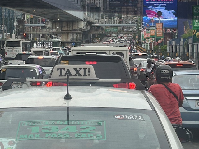
Traffic congestion along EDSA
I’ve taken some photos of EDSA traffic as well as the EDSA Carousel buses. Here are the more recent EDSA photos I took as I traveled from Makati to Quezon City after serving as a panelist in the Energy Transitions Dialogue last Wednesday.
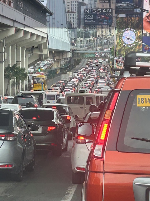 I took this photo as we passed Guadalupe. I like this in the sense that it shows the clear ROW for the EDSA Carousel buses. One wonders why most of these motorists would prefer to drive their vehicles rather than take the bus or the MRT.
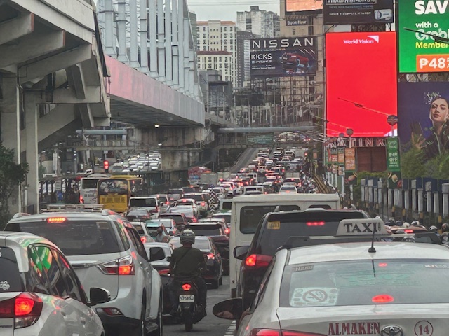 You can see in the photo that EDSA’s northbound side is clogged as far as the eye could see. If you check the image under the MRT bridge, it shows the southbound side was also congested. These photos were taken around 4 PM so this was still an hour before most people would be going home from work.
 I mentioned in my comments at the panel that one consequence of giving number coding exemption to electric and hybrid vehicles is that this further diminishes the effectiveness (is it still effective?) of the MMDA’s number coding scheme. I don’t have the stats of how many EV’s and hybrids are registered and running in Metro Manila. Those numbers combined with actual counts will tell us how they are impacting traffic. That would be a nice topic for a paper. 🙂
The photos pretty much describe the transport situation in Metro Manila. Many of our major cities will be heading this way unless they improve their public transportation fast. If they do, then public transport mode share will be sustained if not increased. Metro Manila’s is already being eroded by inefficient public transport, motorcycles (including taxis) and perhaps unintentionally, electric and hybrid vehicles.
–
Is there really a shortage of public transportation in Metro Manila? – Part 1 – Introduction
I will be doing a series of articles here on public transportation. More specifically, I will try to answer the question in the main title of the series – Is there really a shortage of public transportation in Metro Manila?
The quick answer probably is “yes” but we need to examine this concern from different perspectives and reasons so we can be objective about the “why” part of the shortage. Shortage may mean a real lack in terms of the number of public utility vehicles (PUVs) with approved franchises or perhaps the number actually operating on any given day. These two are actually different because it is possible to have fewer PUVs operating compared to the approved number or to have more PUVs operating than the approved number. The latter means there are “colorum” or illegal operations (i.e., vehicles providing public transport services without franchises).
Among the reasons why there is a perceived shortage of public transportation are as follows:
- Fewer than the number of franchises approved are operating.
- PUVs are not able to make a reasonable turnaround (e.g., due to traffic congestion).
- PUV drivers and operators refusing to operate their vehicles.
- Other factors.
- Any combination of the above including “all of the above.”
I hope I can write about these in a manner that can be easily understood – in layman’s terms.
–
Article share: On AI as a tool for urban planning
Here is a quick share of an article on AI and its application to urban planning. I haven’t written about artificial intelligence here except maybe mentioning it along the lines of intelligent transport systems (ITS). There were what were termed as Expert Systems but AI now (including its potentials) is much more than the expert systems developed in the past.
Sanchez, T. (June 20, 2025) “In Urban Planning, AI Prompting Could be the New Design Thinking,” Planetizen, https://www.planetizen.com/blogs/135418-urban-planning-ai-prompting-could-be-new-design-thinking [Last accessed: 7/17/2025]
To quote from the article:
“Working across disciplines is essential. Collaborating with architects, landscape architects, engineers, artists, and technologists brings in diverse perspectives that can help spark new ideas. AI integrates knowledge and techniques from each of these fields. Contributing to a culture where planners feel free to experiment, where trying something new is encouraged rather than being frowned upon, is key to real innovation. Whether engaging with colleagues or prompting an AI model, creativity thrives in conversation and collaboration…
Cities should be shaped by creative thinking, and today’s challenges demand more of it than ever. Planners are in a unique position to combine deep local knowledge with new technologies, such as AI, to imagine, design, plan, and implement. AI should be seen not as a shortcut, but it has incredible potential as a partner or assistant with encyclopedic knowledge that helps planners stretch their creativity even further. As Wright advises, planners should challenge themselves with constraints to spark creativity: For instance, “What would you do if you had to write an entire zoning ordinance with 10 rules or less to make a sustainable built environment?” Such exercises encourage us to set clearer goals and find better solutions.
By combining traditional tools with emerging technologies, planners can design places that are not only functional but also vibrant, equitable, and resilient.”
What do you think about AI and its applications to urban planning including transportation and traffic?
–
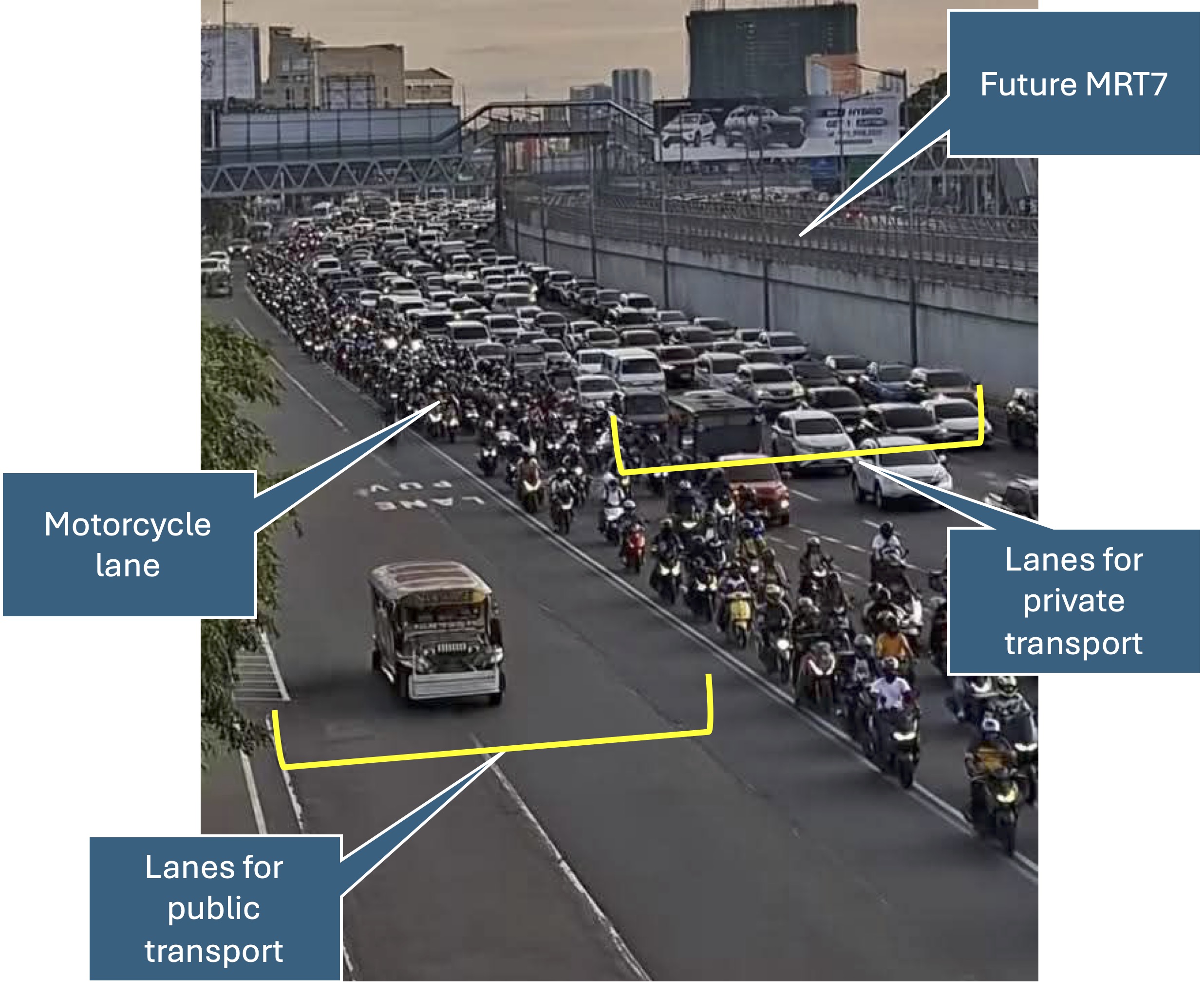
Quick comments on the NCAP
The No Contact Apprehension Policy (NCAP) is finally being implemented in Metro Manila. The results so far has been dramatic in terms of the number of violations recorded and the images being shared so far about how motorists are behaving. Below is one of those photos being shared on social media to which I added some annotations. I will use this later to comment on the NCAP and how we can use the outcomes to assess the transportation situation and determine what interventions can be done. Some are already obvious from the photo – the lack of public transport options lead to people depending on private motor vehicles like cars and motorcycles for their commutes. MRT7 is yet to be operational and road public transport has not been rationalized.
More on this topic soon!
–
Solutions to transport problems: the combination of congestion pricing and transit infrastructure development
Congestion pricing and transit infrastructure development (e.g., mass transit infrastructure) are often mentioned separately or independently. It is as if they are mutually exclusive alternatives or solutions to our transportation problems. They are not and should be considered together for greater impacts and also to complement each other. While the article below focuses on the experience in the United States, the experience is Singapore as applied to cities should provide a model that can be adopted if not outrightly replicated. Singapore’s version of congestion pricing in the form of its Electronic Road Pricing (ERP) scheme has been very effective in regulating congestion levels while helping fund public transportation in the city-state.
Descant, S. (May 8, 2025) “Congestion Pricing and Transit Are a Necessary Alliance,” Government Technology, https://www.govtech.com/transportation/congestion-pricing-and-transit-are-a-necessary-alliance %5BLast accessed: 11/05/2025]
Quoting from the article:
“In order to move a congestion pricing proposal forward, “you must have serious congestion, and you must have good transit,” said Sam Schwartz, a former New York City traffic commissioner, said during a March 21 panel on the New York City congestion pricing program. The event was organized by the Massachusetts Institute of Technology (MIT) Mobility Initiative. Schwartz is also the CEO of Sam Schwartz Pedestrian Traffic Management Services, a consulting firm.
A recent report by the Mineta Transportation Institute at San Jose State University in California concluded roadway tolling — a form of congestion pricing — can serve the dual purpose of reducing traffic congestion and supporting transit options, if the programs are structured properly.”
–
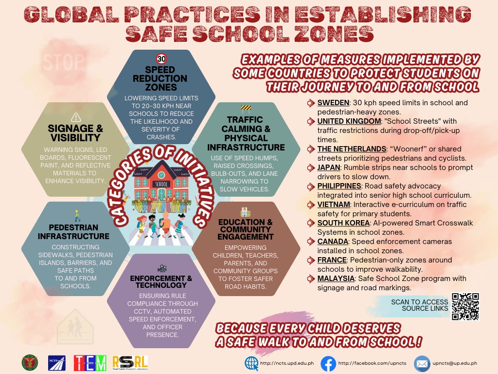
On safe school zones
We’ve been working for safer roads since I started practicing as a transportation engineer/planner. Most recently, we were working on a program supported by UNICEF on Child Road Traffic Injury Prevention (CRTIP). The work towards safer roads especially for those who are most vulnerable is always challenging but it is something that is definitely worthwhile. As we approach May, which is Road Safety Month in the Philippines, I will try to write more about road safety.
Here is an infographic shared by the Road Safety Research Laboratory of the National Center for Transportation Studies of the University of the Philippines:
–
On understanding road diets
I’ve written and shared articles on road diets and complete streets before. Here is another article share on road diets
Johnson, R. (April 21, 2025) “Explainer: What is a Road Diet – And Why Should Cities Embrace It?,” Momentum Magazine, https://momentummag.com/explainer-what-is-a-road-diet-and-why-should-cities-embrace-it/ [Last accessed: 22/04/2025]
To quote from the article:
“The road diet isn’t about punishing drivers. It’s about creating streets that work better for everyone—from the parent pushing a stroller to the teenager biking to school, the delivery driver navigating a tight urban corridor, or the senior walking to the store.
As our cities continue to evolve, road diets offer a cost-effective, data-backed, and scalable way to make them safer, cleaner, and more livable. It’s not just about losing a lane—it’s about gaining a better future for urban mobility.”
Indeed, the first thing that usually comes to mind of motorists whenever road diets and complete streets are mentioned is that the road space (and consequently capacity) will be reduced. This reduction of capacity is actually from the perspective of the motor vehicle rather than the number of people traveling along a road as well as improving road safety for all. The article is spot on in its discussion on the resistance to road diets (and complete streets). Of course, context is very important here and it is important to identify which roads can be transformed for the transformation to be most effective.
–
On strategies for urban mobility
Here is an interesting article on other strategies for urban mobility:
Menard, T. (March 24, 2025) “Beyond Congestion Pricing: Strategies for Revolutionizing Urban Mobility,” Planetizen, https://www.planetizen.com/features/134601-beyond-congestion-pricing-strategies-revolutionizing-urban-mobility [Last accessed: 4/6/2025]
To quote from the article:
“The common thread among successful urban transportation initiatives is the use of data to make mass transit more competitive. When cities invest in improving the transit experience through technology, service enhancements, and targeted incentives, the results are clear: increased ridership, reduced congestion, and lower emissions. These outcomes benefit not just individual commuters but the broader community as well, contributing to improved air quality, reduced traffic-related stress, and more livable urban environments.
In looking ahead, the lessons from New York’s congestion pricing experiment and the initiatives of other progressive cities offer a roadmap for transit agency leaders worldwide. By embracing data-driven strategies, investing in advanced technologies, and creating the right mix of incentives and disincentives, cities can transform their transportation systems to meet the challenges of the 21st century.
The key takeaway for transit agency leaders is clear: when mass transit is made more attractive, efficient, and competitive with private vehicle use, commuters will respond positively. The data from New York and other cities proves that well-designed transportation policies can yield significant benefits for urban communities. As more cities adopt these innovative approaches, we can look forward to a future of smarter, more sustainable urban mobility that enhances the quality of life for all residents.”
Perhaps the main statement to be emphasized here should be: “The common thread among successful urban transportation initiatives is the use of data to make mass transit more competitive.” How many of our cities are doing this now and in the context of the public transport rationalization and modernization? Does the LTFRB or the DOTr collect and use data towards improving public transportation? Are these efforts comprehensive rather than selective?
–
