
Home » Transport Planning (Page 21)
Category Archives: Transport Planning
On BRT being a game changer for Philippine cities
There’s a nice interview about transport on ANC’s early morning program. The topic is bus rapid transit (BRT) and the interviewee is a colleague of mine at the University of the Philippines. Dr. Cresencio M. Montalbo, Jr. is actually a faculty member of the School of Urban and Regional Planning (SURP) and a Fellow at the National Center for Transportation Studies (NCTS). Here’s the link to the interview:
Will bus rapid transit (BRT) remove bias against public transport?
–
Is Antipolo ripe for high capacity and premium transit services?
About 5 years ago, I wrote about transport in Antipolo in another blog. The article was more about this old city being a major destination attracting people for pilgrimage (Shrine of Our Lady of Peace and Good Voyage) and tourism (e.g., Hinulugang Taktak). I am quoting from that article from 5 years ago and adding a few comments here and there. Note that for most of the article, nothing much has changed except perhaps that the Line 2 extension from Santolan to Masinag is now underway.
“There are now many ways from Metro Manila and its neighboring provinces to Antipolo, although several of these eventually merge into three main roads en route to the Shrine. One is via the old route along Ortigas Avenue, a second is the route via Sumulong Highway, and the third is through a “back door” via the Antipolo-Teresa Road. Routes from the general areas of Manila, Makati, Pasig, Mandaluyong, Taguig and the southern cities of Metro Manila and towns from Laguna, Batangas and Cavite will most likely merge to Ortigas Avenue. Meanwhile, people coming from Quezon City, Caloocan, Marikina, Bulacan, Pampanga and the northern Rizal towns of San Mateo and Rodriguez (Montalban) will likely converge along Sumulong Highway. Meanwhile, those coming from the east including the Rizal towns like Tanay, Teresa, Morong, and Jala-jala, the Laguna towns like Paete, Pakil, Pangil, the Quezon towns of Luisiana, Lucban, Infanta and General Nakar, and others will most likely take the Antipolo-Teresa Road that climbs from the east of Antipolo. People from Marikina, Cainta and Pasig generally may take either the Ortigas or the Marcos Highway/Sumulong Highway route.”
I didn’t mention there that another backdoor was via Marcos Highway if one were coming directly from Tanay instead of through Teresa. This route is now popular and traffic has been steadily increasing due in part to some additional attractions in that part of Antipolo and Tanay.
“Public transport to Antipolo these days include mostly jeepneys as the city is the end point of many routes – a testament to its importance even as a reference point for public transportation. One can easily spot the Antipolo-Cubao jeepneys in the Araneta Center in the Cubao business district in Quezon City. There are two lines, one via Cainta Junction (where jeepneys eventually turn to Ortigas Avenue) and another via Marcos Highway, turning at the Masinag Junction towards Sumulong Highway). Another terminal is at the EDSA Central near the Ortigas Center in Mandaluyong where Antipolo-Crossing jeepneys are queued. And still there is another, albeit somewhat informal terminal near Jose Rizal University (JRU, which was formerly a college and hence the old JRC endpoint), which passes through Shaw Boulevard, Meralco Avenue and eventually turns towards Ortigas Avenue. Other jeepneys from the Rizal towns all have routes ending in Antipolo Simbahan, referring to the shrine.”
There are also UV Express and shuttle vans (legitimate vans for hire or colorum operations) offering express trips between Antipolo and the same end points of Cubao or Crossing. Others go all the way to Makati in the Ayala financial district. These evolved out of the Tamaraw FX taxis that started charging fixed fares during the 1990’s and competed directly with the jeepneys. These are popular, however, with office employees and students during weekdays and the nature of their ownership and operations do make them serious competitors to the jeepneys even during the merry month of May (fiesta period) and the Lenten Holy Week.
“There was an Antipolo Bus Line before. These were the red buses that plied routes between Antipolo and Divisoria in Manila. These died out sometime between the late 80’s and the early 90’s probably due to decreasing profitability and likely because of its competition with the jeepneys. That bus company, along with the green-colored G-Liners, the red EMBCs (Eastern Metropolitan Bus Co.) and CERTs, and the blue Metro Manila Transit Corp. buses used to form a formidable mass transport system for Rizal and the eastern towns of Metro Manila. There were even mini-buses (one I recall were the Antipolo “baby” buses and those that plied routes betwen Binangonan and Recto with the cassette tapes stacked along the bus dashboard). Most of these, except the G-Liners eventually succumbed to the jeepneys.”
At present, there is another bus company operating along Ortigas Ave and the Manila East Road – RRCG. There is also a revival of the EMBC with buses providing transport services between Quiapo and Tanay. The only other bus is the inter-provincial Raymond Transit, which operates between Crossing, Mandaluyong and Infanta, Quezon via Antipolo, Teresa, Morong and Tanay.
“In the future, perhaps the jeepneys should give way to buses as the latter will provide a higher level and quality of service along Ortigas Avenue and Marcos and Sumulong Highways. Already in the drawing boards is a plan to ultimately extend LRT Line 2, which currently terminates at Santolan, Pasig, to Masinag Junction and then have a branch climb along Sumulong Highway and terminate near the shrine. This will bring back the trains to Antipolo and would surely make the church and the city very accessible to people. I look forward to these developments both in my capacity as a transportation researcher-engineer and a Catholic who also visits the Shrine to pray for safe travel for loved ones and myself.”
This proposition for rationalizing public transport to/from Antipolo and other towns of Rizal plus Marikina is all the more important as the Line 2 extension from Santolan, Pasig to Masinag, Antipolo is currently underway. There is an opportunity here to upgrade public transport following the hierarchy of transport modes. I have noticed, for example, electric and conventional tricycles providing what are basically feeder services but along Marcos Highway between Cogeo and Masinag. And a lot of people have been stranded or have difficulty getting a jeepney or UV express ride along the Marcos Highway corridor. I am aware that the DOTC in the previous administration was mulling an express bus service through Marcos and Sumulong Highways terminating and turning around at Robinsons Place Antipolo. That, of course, never happened but is something that I think is worthwhile and would be beneficial to a lot of commuters.
–
Emergency powers to solve PH transport problems? – A long list of projects
I am sharing the long list of projects submitted by the Department of Transportation (DoTr) to the Senate Committee on Public Services chaired by Sen. Grace Poe. This is a public document and I think should be circulated for transparency and so people will know what projects are proposed to be covered
List of sectoral projects that the Department of Transportation intends to implement and draft bill for emergency powers: dotr-list-of-projects-and-draft-bill
I leave it up to my readers to determine which among the projects listed really require emergency powers. Many I think do not require emergency powers especially since the period requested for such powers is 2 years and not the duration of the current administration’s term. Perhaps those requiring emergency powers would be programs and projects aiming to overhaul our public transport system, which is currently much dependent on road-based modes. Public transportation services do not follow the suitable hierarchy as seen along major corridors served by low capacity modes. An overhaul (i.e., rationalisation) will touch the very sensitive nerves of bus, jeepney, UV express and tricycle operators and drivers and could trigger an avalanche of TROs to prevent or discourage government from doing what should have been done decades ago to bring order to our chaotic transport. I believe emergency powers coupled with the current admin’s political capital (and the “action man” image of Pres. Duterte) can help bring about genuine reform (and change!) to transport in our cities.
–
Monorail in Manila? A proposal in 1969
I am involved in an inter-disciplinary research program with the Third World Studies Center and the Department of Geography of the University of the Philippines Diliman’s College of Social Science and Philosophy. I am very impressed with my co-researchers being able to find a lot of material including tons of stuff on the Manila tranvia from the National Archives of the Philippines. These are currently being scanned and electronic compilations relevant to the program will eventually be made available as part of the deliverables of the projects.
One of the materials they found was a report on a proposed monorail system in Manila. What we first thought was a single line from an old news report that researchers found turned out to be a network. Here is an excerpt of the report on the proposed monorail system in 1969.
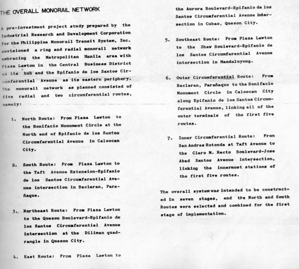
I am posting this snapshot of the monorail report partly for readers to be able to grasp what was going on in terms of public transport planning decades ago. This hopefully allows us to have a firmer grasp of issues behind why public transportation in Metro Manila is so bad. This is given the so many opportunities we had in the past to have something that could have laid the foundation for a more efficient system. While this may be interpreted as some as fault-finding, I would rather look at it as an exercise in learning from a past where a lot of fateful decisions were made regarding both road and rail transport, many of which we now know were unfavorable to public transport and its users, the greater majority of the commuting public. Hopefully, too, this post can generate healthy discussions to point the way forward in improving public transport not only for Metro Manila but other Philippine cities as well. While we can imagine what we could have had now if such systems were realized, we can still look forward to what we can actually have (and for the next generations to benefit from) if we do act towards a better transit system for our cities.
–
On being constructively skeptical on transport and traffic
Social media is full of news or what is being passed off as news about various transport projects or initiatives. These include a proposed subway line for Metro Manila, road sharing initiatives, inter-island bridges, gateway airports and others major infrastructure projects that are being conceptualized, planned, studied or designed. Too often, people who support the projects/initiatives brand those who do not share their enthusiasm and interest as skeptics and even simply “nega” or negative people. These supporters and their opposites are most likely those who fall under one or more of the following categories:
- Overly optimistic
- Unaware of the process towards a project’s realization
- Troll
- Naive
Hopefully, he/she is not of the third kind who basically are posting against anyone and don’t really have any valuable opinion or constructive comment to offer. There are many groups and individuals out there including those who claim to be fanatics of urban planning, railways and other things on transport. Some even get to write in mainstream media. Unfortunately, to the untrained minds their opinions passed on as expert advise appear to be legit and that can be especially true to people who are more inclined to believe them such as very fanatics and trolls I mentioned. It is very important that proper research is undertaken before any article is written. Otherwise, there will always be bias. Of course, some articles are written with bias a given and with the objective of misleading people.
When government officials (or candidates) claim something and offer nothing as concrete proof (e.g., numbers to support a claim of improving traffic), one has to think twice about believing them. One has to be critical of such claims. Promises are often just that – promises. It is important to ask how certain programs or projects will be delivered, how infrastructure will be implemented (i.e., through what mode of financing, timelines, etc.), and what would be its impacts (i.e., social, environmental, traffic). Of course, it should be expected that officials provide suitable answers to these queries.
It should also be expected for officials to understand that institutions such as the academic ones are there to provide objective criticism. Unfortunately, there are those in the academe who themselves have some agenda they are pushing and can be deliberately misleading and misinforming with their flawed assessments and statements. Then there are experts who offer nothing but negative comments. To these people, any idea not coming from them are essentially wrong and it is often difficult to deal with such people among whom are experienced engineers and planners. Being a skeptic is one thing but being a constructive skeptic. That is, one who offers solutions and also willing to tread the middle ground or some reasonable compromise based on the situation and conditions at hand.
This is why an evidence-based approach is needed and should be mainstreamed in many government agencies, particularly those that are involved in evaluations. National agencies like the NEDA, DOTr and the DPWH have the capacity and capability to perform quantitative analysis using recent, valid data. The quality of data tells a lot about the evidence to back up analyses, evaluations and recommendations. One must not forget that with quantitative analysis it is always “garbage in, garbage out”. That is, if you have crappy data, then you will have flawed analysis, evaluations and recommendations.
–
Another look at the Tacloban Airport
The Daniel Z. Romualdez Airport in Tacloban City is the busiest in Region 8 (Eastern Visayas). Tacloban being the regional center in terms of commerce/business, attracts significant air traffic and should continue to do so as it steadily recovers from the devastation brought about by Typhoon Yolanda (Haiyan). Following are photos of the airport from our recent trip to Leyte, where we had meetings in Tacloban and Ormoc.
 Passengers arrive at the Tacloban Airport
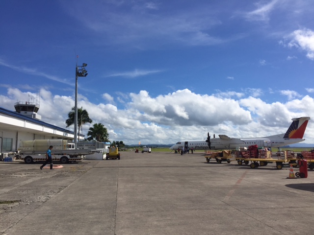 Philippine Airlines turboprop aircraft arriving at the airport
 Cebu Pacific passengers disembarking from the plane
 Passengers waiting for the checked-in luggage at the carousel
 Passengers file out of the arrival area unto the terminal’s driveway and parking lot
 Visitors may inquire about the Tacloban at the city’s information desk located at the arrival area.
 Sign of a rent-a-car service at the airport showing rental options and available vehicle models.
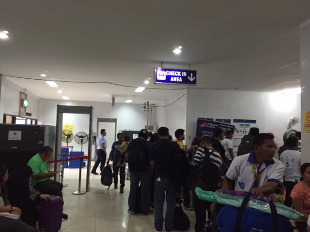 Crowded check-in area at the Tacloban airport passenger terminal
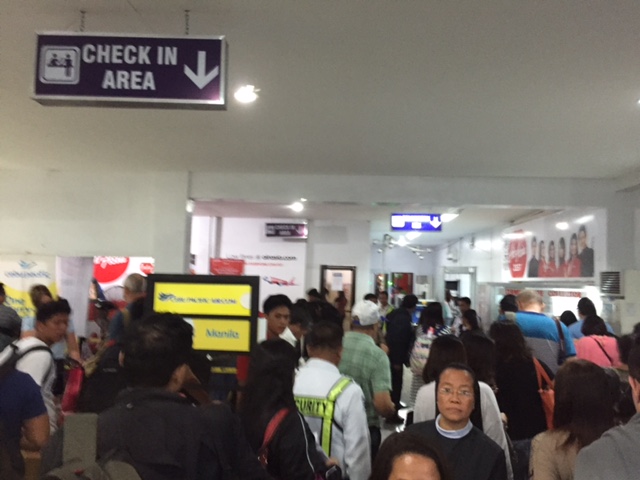 There were long queues at the check-in counters as well as the payment booths for the terminal fee.
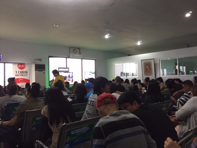 We entered a very crowded departure area as flights were delayed and people accumulated at the terminal. These are Air Asia passengers.
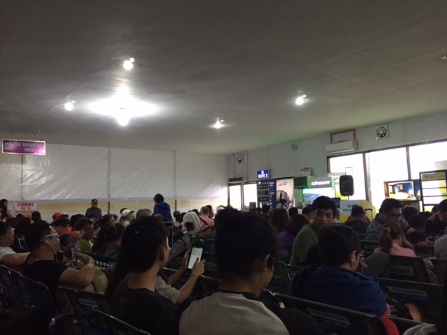 These are Philippine Airlines and Cebu Pacific passengers. Notice the temporary wall behind which is a section of the departure area that’s being renovated.
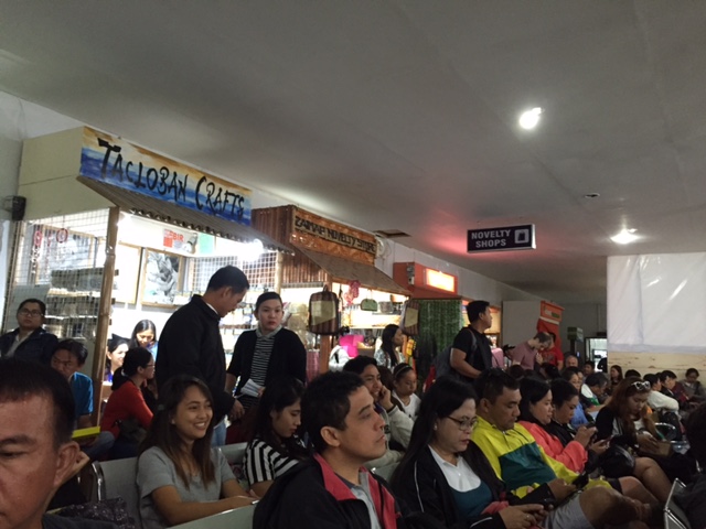 Shops at the departure area sell souvenirs and food items including local delicacies like moron and binagol.
The airport terminal is already very congested and it doesn’t help that flights are frequently delayed for various reasons. In the aftermath of Typhoon Yolanda (Haiyan), there have been proposals to move the airport to another location. However, it now seems that there is no better location for this within the city and elsewhere in the province. There are opportunities and potential though to improve the current airport and perhaps make it more resilient against typhoons of the scale of Yolanda.
The proposed new passenger terminal building is already much delayed and the runway can be extended. The latter is now possible with the areas for the extension already cleared of informal settlers mainly due to these areas being ravaged by Yolanda and authorities not permitting people to rebuild their houses there.
–
Straddling bus prototype?
What was peddled as a unique public transport mode concept in social media is now a reality. Check out the article and video here:
China’s Futuristic Straddling Bus Is Finally Here
This is a welcome development for public transportation. However, some issues need to be addressed, particularly regarding road safety. Motorists traveling under the straddling bus may have reactions to the vehicle as it passes above them and such may lead to road crashes. Of course, with the advent of driverless vehicles such incidents may be minimised if not altogether eliminated.
–
Evidence from Montreal: Building bike lanes to reduce car use
I just wanted to share this article showing evidence of car use reduction (and therefore, car traffic along roads) with the provision of bicycle lanes.
Building Bike Lanes Really Does Get More People Out of Their Cars
The article though cautions readers against generalising or assuming great improvements. Some figures mentioned in the article including the following (I took the liberty of copying and pasting):
- “A 10% increase in bike accessibility resulted in only a 3.7% increase in ridership.”
- “…cycling infrastructure also reduced greenhouse gas emissions from cars by 1.7%, a reduction equivalent to converting transit buses to hybrids and electrifying commuter trains.”
These numbers are for the case of Montreal, Canada. Not mentioned are the number of cyclists, vehicle traffic volumes and other pertinent data that are useful in analysis. The article correctly points out the importance of using science (e.g., sound analysis based on good data) in order to convince governments to put up bicycle infrastructure. I would even add that this approach should also be applicable to pedestrian facilities.
–
Standards for integrated railways in the Philippines
With the recent pronouncements about railway projects in Metro Manila including the ongoing Line 2 Extension to Masinag, the impending construction of Line 7 (i.e., along Commonwealth and Regalado Avenues and Quirino Highway) and the proposal for a Line 4 (Diliman, Quezon City to Lerma, Manila), it becomes more imperative to have integrated railway infrastructure including and especially common stations where lines intersect and common specifications guided by standards or guidelines. Do we have such or has there been work towards their formulation in the past? The simple answer to that question is yes. But then we have to qualify that affirmative response because while there was a study a decade and a half ago, the outcomes of that study, which is a comprehensive take on all aspects of railway systems was never formally adopted (again?) by the Philippines.
The following link is for the Executive Summary of the “Study on Integrated Railway Network for Metro Manila (SIRNMM) completed in 2001.
Perhaps there is a need to revisit the outcomes of this study? This can serve as a good platform from which updated guidelines and standards can be developed for a more harmonious development of railways systems not just for Metro Manila but for other cities as well.
–
Mobility for persons with disabilities
I saw these two people traveling along Marcos Highway just after the intersection with Imelda Avenue. I think they came from Tahanang Walang Hagdanan in Cainta. The tricycle is actually modified to allow for a person with disability to operate the motor vehicle. The side car is also customized to carry a person on wheelchair. Note that back of the sidecar? It is actually a ramp that is locked when traveling but can be lowered for wheelchairs to roll-on or roll-off. Since there are two persons on the vehicle, the driver’s wheelchair is seen folded and loaded in front of the lady on her wheelchair.

Such vehicles allow PWDs to be more mobile. Unfortunately, most public utility vehicles do not have features to allow wheelchair-bound people to ride on them. Such features may be seen in city buses in more progressive cities including those in Japan, Europe and the US. Trains can easily accommodate PWDs including those on wheelchairs as their floors are the same level as the station platforms and there is space inside the cars for PWDs. While access for PWDs is already contained in Philippine laws, there is still much to be done in terms of implementing provisions of such laws especially with respect to road-based public transportation.
–
