
Home » Transport Planning (Page 25)
Category Archives: Transport Planning
Finally, the LRT Line 2 Extension begins construction
The groundbreaking ceremony for the extension of the LRT Line 2 from Santolan, Pasig City to Masinag Junction in Antipolo City was held last June 9, 2015. This marks the beginning of the construction of the much anticipated and much delayed extension of the line to what was supposed to be part of the first phase of Line 2. I say supposed because most experts believe the current line should have terminated at Masinag from the start instead of at Santolan where the depot is located. Masinag had much more sense many years ago as it was a good staging point for possible extensions to Cogeo, Antipolo City proper or Marikina City. The areas along the Marcos Highway corridor beyond Masinag alone have experienced tremendous growth especially after the floods of Ondoy (Typhoon Ketsana), which submerged much of the Marikina Valley including Pasig, Cainta and lower Antipolo.
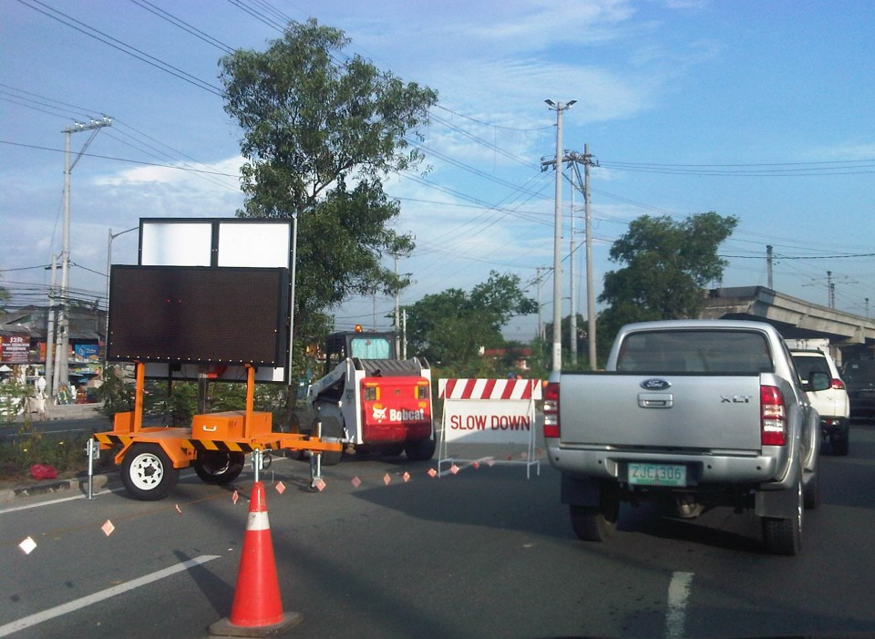 Traffic cones and signs guide motorists away from the inner lanes of Marcos Highway.
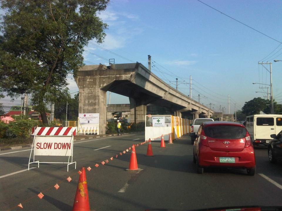 Two lanes from each side of Marcos Highway at the current end of the Line 2 were appropriated in addition to the median for the groundbreaking ceremony.
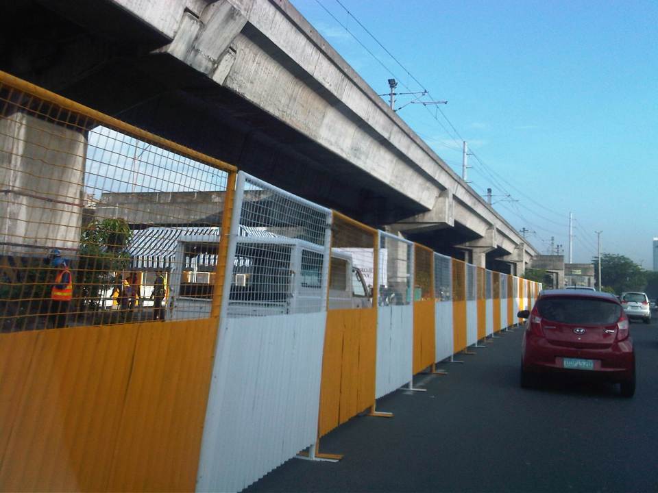 The stage is set – the stage for the ceremony is set under the viaduct with these barriers practically shielding the participants from curious passers-by (usyoso). Regardless, the event cause congestion along the highway.
Of course, that was the groundbreaking ceremony. As of today, there’s no sign yet of the contractor, DMCI, fully mobilizing and already reserving the inner lanes of Marcos Highway for the construction of the viaduct and stations. If the current works for the NAIA Expressway in the airport area is to be a reference, then severe traffic congestion is to be expected along the highway and this will extend beyond the actual construction site from Santolan to Masinag. As such, the public will experience inconvenience for the next so many months or perhaps couple of years (or more if there were delays). However, I believe that once the line is operating all the way to Masinag, it will help to ultimately decongest Marcos Highway and Aurora Boulevard and a lot of people will benefit from the improved travel times.
Incidentally, the term LRT is actually a misnomer here because among the 3 operational rail mass transit lines (I am excepting the PNR Commuter Line here.) in Metro Manila, Line 2 is actually a heavy rail system. Perhaps the government should already correct this by simply referring to Line 2 as ‘LRTA Line 2’ or renaming LRTA to reflect its nature as a transit authority that should not be limited to light rail only.
–
On the new transport categories by the DOTC
An article came out recently about the four new transport categories introduced by the Department of Transportation and Communications (DOTC).
These are:
- Transportation Network Vehicle Service (TNVS),
- Premium Taxi,
- Airport Bus, and
- Bus Rapid Transit
To quote from the article from Rappler, TNVS are:
“Vehicles of application-based, ride-sharing service providers, like Uber, GrabTaxi, Tripda, and EasyTaxi, will now fall under the category TNVS.
TNVS will cover vehicles that provide pre-arranged transportation services for compensation, using an online-enabled application or platform technology to connect passengers with drivers using their personal vehicles, Abaya said.
These new rules will also allow ride-sharing service providers to accept regular passengers heading to any point of destination in the country, Abaya added.
Operators of TNVS, called Transportation Network Companies, are also required to screen and accredit drivers and register them with the Land Transportation Franchising and Regulatory Board (LTFRB).
All TNVS vehicles will also be required to install and use global positioning system (GPS) tracking and navigation devices. Only sedans, Asian Utility Vehicles, Sports Utility Vehicles, vans, or similar vehicles will be allowed, and these should not be older than 7 years.
The new framework makes the Philippines the first country to have nationwide rules on ride-sharing, according to both the Philippine transport department and Uber. Previously, only local and city governments have regulated the services…”
Premium Taxis are described as:
“…vehicles with a 7-year age limit under this new category will be equipped with GPS, online and smartphone booking capability, and cashless transactions through credit or debit card payments.
Like TNVS, premium taxis will be allowed to accept regular passengers heading to any point of destination in the country…”
And Airport Buses are:
“…should have fixed schedules and off-street stops, low-floor height and adequate luggage space, CCTV cameras, GPS device, free WiFi, and must run on Euro V or clean alternative fuel.”
Abaya pointed out that Green Frog has expressed interest in the airport bus service that would ply three areas including Makati City, Mall of Asia (MOA) as well as Bonifacio Global City (BGC) or Ortigas business centre…”
I won’t mention the BRT anymore. It deserves its own feature (as if the previous ones on it are not enough to describe the system), and is the only mass transit among the 4 categories “introduced” by the DOTC.
These new transport categories are obviously a step in the right direction. These are not new ideas and the institution of these categories by the DOTC is long overdue considering that the agency had to go through this process in order to address legal issues pertaining to such services. In the case of TNVS and Uber, for example, much has been mentioned about franchise issues and how Uber was illegal under the prevailing set-up. It is good to have another option to the regular taxis but then weren’t GrabTaxi and EasyTaxi were supposed to have enhanced services?
As for airport buses, such limousine services have been in operation in many other countries. Unfortunately, in Metro Manila’s case, these buses would have to contend with worsening traffic conditions along most major roads connecting the airport terminals to the various points of interest mentioned in the article (e.g., Makati CBD, BGC, Ortigas CBD, etc.). It is good though that Green Frog was mentioned in the article as the new category provides an opportunity for cleaner and more efficient technologies to be applied to transport services. Still, if these services will be operated by reckless drivers then they won’t be much better than what we already have at present.
–
Metro Manila Urban Transport Development Plan (1990-2000) Project (UTDP)
I stumbled upon an unfinished draft I have on a study or series of studies conducted back in the 1990’s. These studies were conducted by several agencies over a decade. I think I have been procrastinating on finishing this brief post on a project that has had a major impact on Metro Manila transport and traffic since that time and prior to the completion of the JICA-funded Metro Manila Urban Transportation Integration Study (MMUTIS) in 1999. The project actually overlapped with MMUTIS’ implementation from 1996-1999 and probably influenced MMUTIS in terms of what government agencies provided as inputs to the study.
The Metro Manila Urban Transport Development Plan (UTDP) is an inter-agency collaboration among the DOTC, DPWH, MMA (precursor of the MMDA), NEDA, CHPG (Constabulary Highway Patrol Group of the Philippine National Police) and MTPC. This consists of various studies undertaken from the year 1990 to 2000 aimed to determine what projects can be implemented to improve urban transport in Metro Manila towards the turn of the century. Sounds familiar?
Among the most relevant studies conducted was the comparison of proposals for a mass transit system along EDSA. The two proposals compared were the Philtrak bus system and Street-level LRT. The Philtrak option is quite intriguing because its description is very much like the current bus rapid transit (BRT) systems in many cities around the world. However, there is no reference to bus systems already operating abroad at the time (e.g., Curitiba in Brazil already had an extensive BRT network at the time).
The study concluded that the Philtrak was preferable to the LRT along EDSA. Of course, we now know what got built along EDSA – a light rail system (EDSA MRT) that is now carrying more than twice the number of passengers it was estimated to carry. This is despite the conclusion from collaborating government agencies including the DOTC favoring the bus system with an exclusive ROW. It is also now obvious that neither the LRT nor Philtrak is most suitable as a mass transit system along EDSA. What is most appropriate is a heavy rail system that would be able to carry more passengers along the corridor.
[Reference: UTDP reports, 1999-2000, NCTS Library, UP Diliman]
–
End game: flyover frenzy
The Manila Bulletin featured news on the Japanese government extending a loan to the Philippines for road projects in Metro Manila that include the construction of several major interchanges. An excerpt from the article is as follows:
The Japanese government will be providing some P4 billion to the Philippines for road projects aimed at decongesting monstrous traffic jams in Metro Manila.
Noriaki Niwa, chief representative of the Japan International Cooperation Agency (JICA), said the loan will cover major interchanges to address traffic congestion in Metro Manila, including flyovers, and road links.
Among them are the interchanges on EDSA/Roosevelt/Congressional, EDSA/West/North, and C-5/Green Meadows and North/Mindanao Avenue.
“This is to help Metro Manila sustain growth and develop it as an attractive investment destination,” said Niwa.
While these interchanges have been recommended many years ago and are also reiterated in the recent transport roadmap for Mega Manila, one cannot help but make the observation that these projects will not alleviate congestion over the long term. Instead, it will likely encourage more vehicle traffic (with the availability of more road space – part of a vicious cycle).
Other major projects that are ongoing in Metro Manila include the NAIA Expressway, which is an elevated tollway connecting to the Skyway. A friend commented that this is basically a glorified flyover project as I will explain later in this post.
 NAIA Expressway construction in full swing – a column rises near NAIA Terminal 3
 NAIA Expressway elevated sections nearing completion across from Terminal 3
The term of the current administration concludes next year (2016) and so we are almost in the endgame, to borrow a term from chess. What seems to be a frantic move for the government to build all these flyovers (and elevated tollways) can be interpreted as a way to compensate for the underspending and underachieving ways of the government in putting up the necessary infrastructure to address transport and traffic problems in urban areas. Unfortunately, all the funding (public and private) seems to be going to road projects instead of to mass public transport systems like rail and BRT that should be the priority because these could provide the positive impacts over a longer term than what road projects could deliver in terms of mobility and sustainability.
A friend reminded me of a similar situation back in 1991/92 when government embarked on a slew of flyover projects in an effort to leave a legacy in transport. That administration’s excuse for failing to deliver any mass transit project was that it was transitioning from a dictatorship. However, it also failed to deliver on power projects, which led to the energy crisis that had to be solved quickly (but with costly PPP power plant projects). There is a looming energy crisis now but more worrying is a transport crisis as we continue to procrastinate about public transport infrastructure. Should we be hopeful of transport with the next administration? That is still a big question as of now.
–
If you build it, will they come?
There seems to be a belief among the more zealous advocates of sustainable transport that if “you build it, they will come.” It seems cliche but this saying is not necessarily applicable to many things especially when referring to transport infrastructure. There are examples of roads, terminals and other transport facilities that have been built but sadly are underutilized mainly due to the demand just not being there and taking much time to attain. The last is usually due to the fact that certain conditions or prerequisites have not been satisfied. One such example of this is the case of the Subic-Clark-Tarlac Expressway (SCTEX), whose payment for the loan that covered the construction costs was premised on a very high traffic demand forecast. It took some time for more people to use the expressway as the traffic from the major developments (Clark, Subic, Tarlac and Bataan industrial and commercial developments) just didn’t happen as immediately as assumed in the forecast. Still, there is a strategic value to such major infrastructure considering it as an investment and something that will cost a lot more in the future if not built today.
In Metro Manila, the MMDA has allocated or designated lanes for cycling along several major roads. These included the lanes they created out of painting existing pedestrian sidewalks and marking these as bikeways. One section is between Magallanes and Ayala while another is from Ortigas to White Plains. These are poorly designed, “pwede na yan” types of bikeways that people on bicycles would find very difficult to use because the course is full of obstacles. And how about the plight of pedestrians who would have to share these narrow paths with cyclists? Such mixed signals on providing for the needs of pedestrians and cyclists are not necessary unless of course the main objective of this exercise is just to get the attention of a wider audience that is the general public, which I would strongly agree is needed to advocate for sustainable transport. Focus on the ultimate goal, however, should not be lost for what appears as small victories. Perhaps an even stronger initiative should be towards having the DPWH revise road design guidelines to incorporate walking and cycling requirement especially for national roads.
 Bicycle lane along Julia Vargas Ave. in Pasig City
Cebu City enacted an ordinance essentially promoting cycling through the planning and implementation of bikeways, bike lanes or shared lanes. However, initial efforts seem to be following the MMDA’s “pwede na yan” approach. I think Cebu could do better and come up with a better plan for integrating and mainstreaming bikeways into the transport network. But of course, a lot still needs to be done for pedestrian facilities.
In conclusion, building transport infrastructure is not an assurance that it will generate its intended benefits at once. However, some infrastructure are more strategic than others as perhaps they form part of a network. Expressways in Luzon are among these strategic investments. High standard highways in Mindanao are also essential. Rail rehab and building in Luzon is strategic. The same in Mindanao perhaps is not. Mass transit systems in highly urbanized cities are required but perhaps many should start with buses rather than rail. Bridges across islands are not urgent. International-standard airports in major cities are necessary but not all provinces require such airports. Its not a simple task to determine what will work and what wouldn’t. While it is easy to attribute so many benefits in order to justify a project, such practice would usually result in white elephants that few people benefit from.
–
Some updates on DOST’s AGT
Passing by the DOST compound last week, I saw that the newer of the two AGT prototypes the Department of Science and Technology (DOST) has funded through the Metals Industry Research and Development Centre (MIRDC) is already atop the test track along Gen. Santos Ave. in Bicutan, Taguig City.
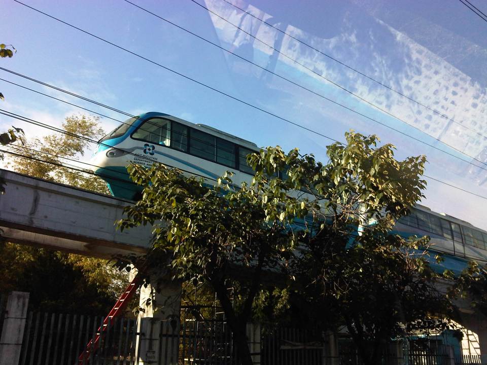 The Bicutan AGT is larger than the prototype in UP. The former is a 120-passenger capacity train while the latter is a 6-passenger vehicle.
There are four on-going pre-feasibility studies on proposed AGT lines – UP Diliman in Quezon City, Litex in Quezon City, Gen. Santos Ave., Bicutan in Taguig City, and Baguio City. I am familiar with the first three, which is being implemented by UP but know little about the 4th, which is being implemented by a private consulting firm. The transport aspects (i.e., ridership estimates) of the Litex and Bicutan AGTs are almost complete and the estimated riderships are not encouraging considering the competition from road-based public transport comprised of jeepneys and tricycles along the proposed alignments.
There is a similar dilemma for the loop option proposed for UP Diliman that will be competing with the jeepneys operating in the campus. That is why another option is currently being studied, i.e., a line connecting Philcoa – the UP Town Center and Aurora Boulevard via UP, C.P. Garcia Ave. and Katipunan Ave. This line presumably would have significant ridership as it passes through major traffic generators in 3 major schools (UP, Ateneo and Miriam) and a commercial area (UP Town Center). It will likely become the mode of choice for people usually passing through the UP campus from Aurora Blvd. to get to Philcoa and beyond, and vice versa. And with the traffic congestion along Katipunan, a transit system with its own right-of-way should have better travel times compared with road-based transport.
A big issue about the AGT vehicles is the certification required before these are allowed to carry passengers in a real system. The current vehicles are prototypes so these will be subject to more refinements towards the model that would actually go into service in the foreseeable future. There is no update on this and the MIRDC and DOST don’t seem to be seeking more rigid and independent tests to certify the safety and integrity of this Philippine-made system. Perhaps the DOTC can help them on this through the LRTA or the PNR?
–
“No” to additional jeepneys?
I finally got a photo of a banner that I’ve seen on many jeepneys plying the Katipunan route. This appeared on jeepneys a couple of weeks ago and the message on it is clear: “No to more jeeps, to more traffic in Katipunan.” I became curious about this as I noticed that list of transport groups that had their names printed at the bottom of the tarpaulin. Noticeable is the absence of one group, Pasang Masda, among the list that includes, among others, LTOP, ALTODAP and the party list group 1-Utak, which used to have a seat in the Philippines House of Representatives.
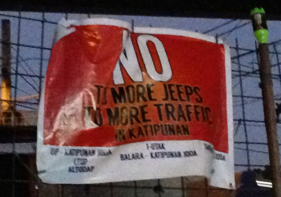 Tarpaulin sign hanging at a wire fence at the Katipunan jeepney terminal under the Aurora Blvd. flyover.
Pasang Masda is supporting the Comet jitneys currently plying the North EDSA-Aurora Boulevard route (via Mindanao Ave., Congressional Ave., Luzon Ave. and Katipunan Ave.). In fact, the head of the group is reported to have bought a few units, likely convinced of it as a good investment. Is it? Only time will tell considering its route is not necessarily the best for it, overlapping with several jeepney routes including the UP-Katipunan route. Is the Comet a game changer? So far, it isn’t and that’s mainly because of its single roue that’s not exactly favorable for a demonstration of the vehicle’s capability and claimed advantage over the conventional jeepneys. A colleague even says that it seems the route approved for it doomed its operation in the first place. But that’s an entirely different story from the opposition to it that’s stated in the tarps at the Katipunan jeepney terminal and some of the jeepneys plying the route.
So, is it a “no” to more jeepneys because their numbers are really already excessive OR is it a “no” because the additional jeepneys are from other groups or those not affiliated or in league with the undersigned? It seems that the latter case applies here and this should be taken as an example of what to expect along the way as initiatives to phaseout or replace conventional jeepneys get going. It is a bit complicated due to mainly to the social aspects of a phaseout or replacement but it gets more complex with the personalities involved including and especially the leaderships of various transport groups.
–
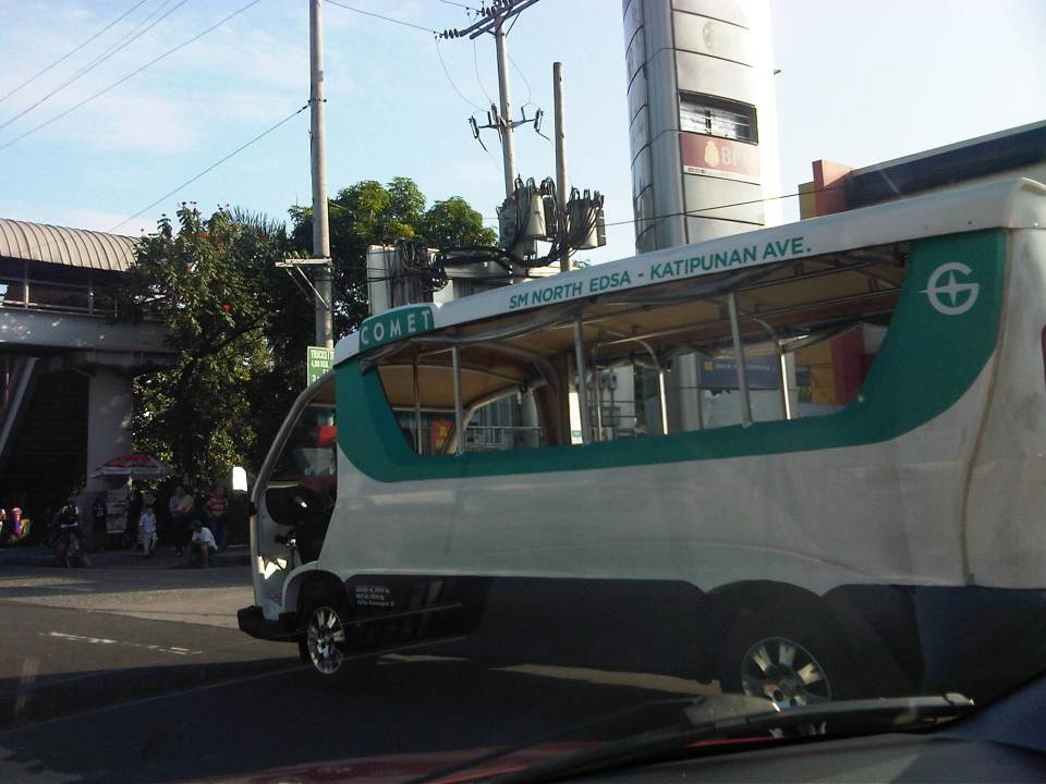
Comet – rare sightings
A colleague was saying that he has not seen the Comet, a jitney-type vehicle currently plying the SM North – Katipunan route via Mindanao Avenue and Commonwealth Avenue, for quite some time. I shared the same observation and this is based on my regular commute that includes travel along Katipunan Avenue. The Comet is becoming, if it is not yet, a rare sighting even considering its relatively long and apparently convenient route. The route passes through residential and commercial areas and would be a direct, single ride for students in particular of three major schools in the Katipunan area – UP, Ateneo and Miriam. It also connects to 2 large malls, SM North and Trinoma, and 2 rail stations, LRT 2 Katipunan Sta. and MRT 3 North EDSA Sta. Despite these traffic generators along its route, it seems that the Comet still has less than the desired ridership. I say ‘seems’ because I currently don’t have the hard statistics on ridership but only observations from those who have seen the vehicle along its route.
 I saw this one on my way home last December in heavy traffic as our jeepney approached the Katipunan – C.P. Garcia intersection. It had few passengers considering its long route from SM North EDSA to Aurora Boulevard via Katipunan Ave.
 An almost empty Comet spotted one morning this January along Katipunan
What is the future for the Comet? It is unclear so far despite the hype and claims that this is supposed to be the vehicle to replace the conventional jeepney. (To be fair, this is what was also said of the e-jeepney that precluded the Comet.) The DOTC does not have a clear and firm policy or commitment to making this work. Its pronouncements have so far been towards deploying the Comet along new routes instead of replacing existing jeepneys on existing routes with this low emission vehicle. I believe that the only way for the Comet to work is for it to be mainstreamed as a replacement for the jeepney and along suitable routes, of course. The DOTC could and should review jeepney franchises to determine how the Comet and other similar low emission vehicles can be phased in over a realistic period in order to modernize public transportation currently being supplied by conventional jeepneys.
I recently noticed that there are jeepneys along Katipunan bearing tarps on their sides stating “No to additional jeepneys.” Underneath are the names of three jeepney groups supporting this call but with the exception of a major jeepney group that’s supposed to be supportive (even owning several units) of the Comet. Are the signs a form of resistance to change? Do the groups know or understand what they are saying and what they stand for? Or are these indicative of disagreements among jeepney groups, operators and drivers regarding the future of their operations using conventional jeepneys?
There will surely be resistance from these sectors if there are changes to be made that will affect their sources of income. It is a very daunting and sensitive task to decouple transport and livelihood in the Philippines. However, the issues coming out of such changes to improve public transport services should be met head on rather than skirt them, particularly in the case of the agencies responsible for these services – the DOTC and the LTFRB. Only then can we have the transformation we need for road-based public transport in this country.
–
The Metro Manila Transportation Planning Study II (JUMSUT II)
Similar to the previous JUMSUT Phase I, the recommendations of Phase II focused on route structure planning and improvement for road public transport to avoid unnecessary competition between LRT, bus and jeepney. Recommendations for route structure planning included the modification of route schemes for the central eastern sector of Metro Manila mainly to alleviate traffic congestion and improve schedules. The study reiterated the recommendations of Phase I.

Following are more photos showing the recommendations of JUMSUT II:

[Reference: JUMSUT II Final Report, NCTS Library, University of the Philippines Diliman]
–
The Metro Manila Transportation Planning Study I (JUMSUT I)
I continue with the series of posts I had started last year on past studies conducted for Metro Manila. It is important to review these studies in order for us to understand how transport in the metropolis came to be how it is now. I believe there are many lessons to be learned and history does not need to repeat itself (although as we can see, it has in as far as transport in Metro Manila is concerned).
The Metro Manila Transportation Planning Study better known as the JICA Update on Manila Study on Urban Transport (JUMSUT) was conducted in two phases, the first one from November 1982 – March 1984 and the second from June 1984 – March 1985, respectively, as a follow-up to MMUTSTRAP. JUMSUT focused on studies to support the implementation of the LRT Line 1 project along Rizal and Taft Avenues.

Recommendations of the first phase are mostly on the rerouting of public transport vehicles along LRT corridor and the traffic management required for the construction and eventual operation of the LRT Line 1. The rerouting is presented as a necessity to avoid unnecessary competition between LRT, bus and jeepney as well as to achieve balanced mode share among LRT, bus and jeepney along the corridor. Following are photos showing a summary of recommendations for JUMSUT I.

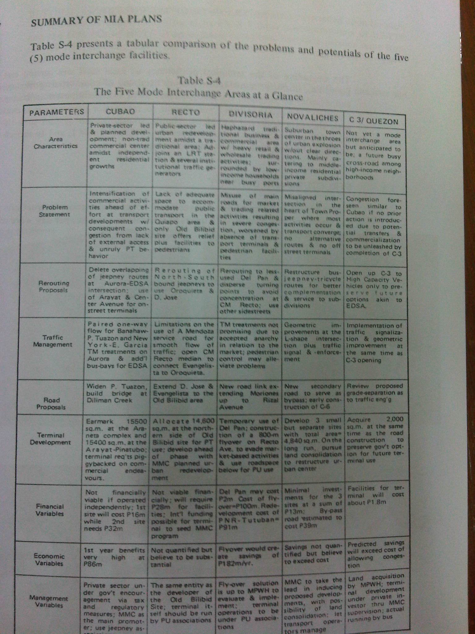
[Reference: JUMSUT I Final Report, NCTS Library, University of the Philippines Diliman]
Next: JUMSUT II
–
