
Home » Transport Planning (Page 4)
Category Archives: Transport Planning
On transportation and global health – article share
I was supposed to write about the keynote lecture delivered during the 30th Annual Conference of the Transportation Science Society of the Philippines (TSSP). I am sharing instead an article written by Dr. Renzo Guinto who is an Associate Professor at the SingHealth Duke-NUS Global Health Institute based at the National University of Singapore.
Here is the link to his article on the Philippine Daily Inquirer: Health at the center of transport and mobility
I will not quote from the article and leave it to my readers to read and appreciate the articles content.
–
Technical sessions at the TSSP 2024 Conference
I am sharing here the latest draft of the technical sessions for the 30th Annual Conference of the Transportation Science Society of the Philippines (TSSP). The conference will be held in Iloilo City this coming September 13, 2024.
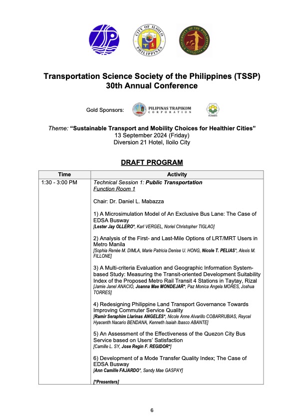
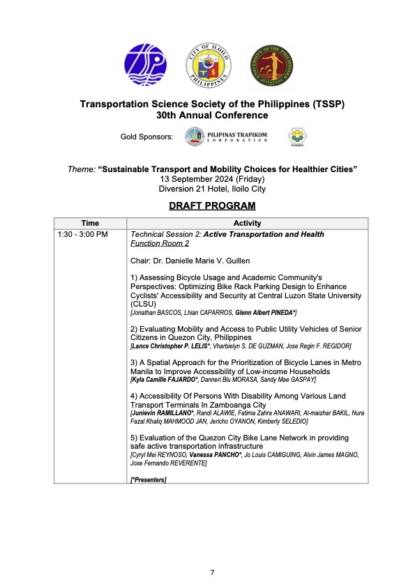
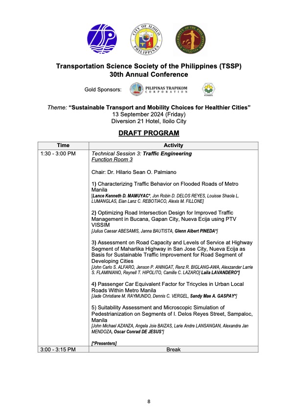
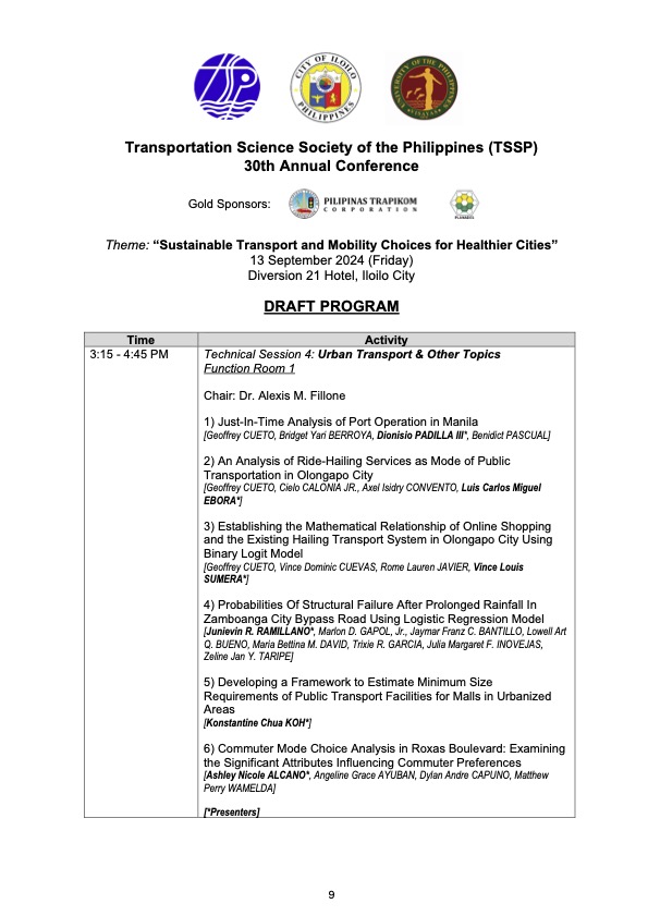
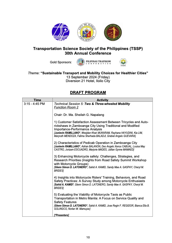
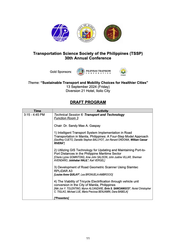
I will share the draft program for the morning plenary session in the next post.
–
SPRINT principles for bicycles
Here is the link to how to improve your city’s or municipality’s bicycle facilities based on scores guided by the SPRINT principles: https://cityratings.peopleforbikes.org/create-great-places
SPRINT stands for:
S -Safe Speeds
P-Protected Bike Lanes
R-Reallocated Space
I-Intersection Treatments
N-Network Connections
T-Trusted Data
The site provides links and examples of good practices of actual bike projects in the US. Many of these can be replicated or adapted to Philippine conditions. These are something that the active transport section of the Department of Transportation (DOTr) should look into and perhaps provide a reference for developing and improving bicycle facilities in the country.
–
On a ‘tipping point’ for bikeability in cities
Here’s a nice article on bikeability and pertains to cities in the United States that developed bikeways or bike lanes during the pandemic. Like many cities that have ‘discovered’ cycling as a viable mode of transport particularly for commuting during the COVID-19 pandemic, it is postulated that there would be a threshold when people would switch to cycling and/or demand for more cycling facilities.
Wilson, K. (June 25, 2024) “Has Your City Passed the ‘Bikeability Tipping Point’?,” StreetsBlog USA, https://usa.streetsblog.org/2024/06/25/has-your-city-passed-the-bikeability-tipping-point [Last accessed: 7/2/2024]
To quote from the article:
“A whopping 183 American communities achieved a score of 50 or higher on PeopleForBikes annual City Ratings this year, up from just 33 in 2019. The means 183 communities have scored at least half of the available points on the group’s signature “SPRINT” rubric that includes such measures as protected bike lanes, safe intersection treatments, and reduced speed limits that are unlikely to kill a cyclist in the event of a crash, among other factors.
And when a city clears that 50-point threshold, the authors of the ratings say that its local bike culture has firmly taken root — and that every new roadway improvement will inspire more improvements, rather than a fierce fight against a car-dominated status quo.
“Once you’ve hit 50, your city probably has a pretty good low-stress bike network,” said Martina Haggerty, the senior director of local innovation at PeopleForBikes. “[That’s] not to say that there aren’t still improvements to be made [but it] probably means that more people are riding bikes in those communities because they feel safe and comfortable. And when more people start riding bikes, those people tend to become advocates for better bike infrastructure and for pro-bike policies, which, [in turn,] will get more people riding.”
There are many links found in the article itself that are “click worthy”. I recommend the reader to explore the rubric from PeopleForBikes and see for yourself how this can be adopted for your city. Is such a rubric applicable to the Philippines? Perhaps, but there would be a need to assess the the situation in each city or municipality. So far, there have been mixed reviews among cities, especially those that appeared to have been more progressive and were more aggressive than others in putting up bicycle facilities including bike lanes. Perhaps the rubric can be applied to see how our LGUs measure up?
–
On BRT being the solution to many cities’ public transport problems
Here is a very informative article about the benefits of a bus rapid transit (BRT) to a city:
Renn, A.M. (June 17, 2024) “The Bus Lines That Can Solve a Bunch of Urban Problems,” Governing, https://www.governing.com/transportation/the-bus-lines-that-can-solve-a-bunch-of-urban-problems [Last accessed: 6/25/2024]
To quote from the article:
“One benefit of BRT is that it is much more capital-efficient and faster to implement than light rail. For many years, urban advocates have promoted light rail over bus transit, impressed by the success of light rail systems such as the one in Portland, Ore. But today’s light rail lines are extremely expensive. One proposed in Austin, Texas, for example, is projected to cost $500 million per mile. Also, most of the cities that have desired light rail are low-density cities built around cars and with little history of extensive public transit ridership. Converting them to transit-oriented cities would be a heavy lift.
BRT is much cheaper. The 13-mile Red Line BRT in Indianapolis, opened in 2019, cost less than $100 million — not per mile, but in total. The much lower financial lift required for building bus rapid transit makes it more feasible for cities to raise the required funds.
Because they typically run on city streets, BRT systems also offer the chance to perform badly needed street and sewer repairs during construction. Sidewalks can be rebuilt or added. Traffic signals can be replaced, along with new features such as prioritizing buses over auto traffic and additional pedestrian safety measures. The reduction of traffic lanes itself is sometimes a worthwhile street redesign project.”
It’s been more than a decade (almost 2 decades to be more accurate) since a BRT was proposed in Cebu City and in Metro Manila. So far, there is still none operating in the Philippines. The EDSA Carousel probably wants to be one but is far from being a BRT based on operations and performance. Cebu’s is supposed to be currently in implementation but it seems Davao might just beat them to it with its high priority bus project. The Philippines requires a proof of concept of the BRT in one of its cities that could be the inspiration for similar projects in other cities especially those that are already highly urbanized.
–
Article share: Planners’ Complicity in Excessive Traffic Deaths
Here is a recent article on safety and the involvement on traffic engineers from Todd Litman:
Source: Planners’ Complicity in Excessive Traffic Deaths
Let me note here about the interchangeability of the terms ‘traffic engineer’, ‘transportation engineer’ and ‘planner’. This is important to contextualize who is actually complicit or involved or responsible particularly in the Philippine setting. Too often and too quickly, traffic engineers or even civil engineers (in general) are blamed for traffic deaths or flaws in road designs. Disregarded is the fact that, as the article mentions, of the two major elements of travel – distance and speed – distance is often determined by the plans and designs of non-engineers. These are planners, or to be accurate land use planners, many of whom are architects by profession. We also want to differentiate between traffic engineers and highway engineers, who in the Philippine setting are actually quite different. One common thing about many of them is that they are slow to adopt progressive ideas or concepts of road planning and design such as complete streets and road diets. The outcome of this stubbornness is the specter of road crashes that lead to fatalities and serious injuries. But then they are not solely to blame or who should take responsibility for the atrocious road safety situation. The ‘distance’ component of travel is very much a product of land use planning and land development as practiced in our country. For many if not most developments, architects and planners are the ones who call the shots for the roads and transportation in the proposals. Traffic engineers are involved later and if not progressive complicates the situation regarding safety. Thankfully, some local government units are becoming progressive and are more mindful of development proposals including implications to road safety. Hopefully, many things will change among those involved so we can improve travel safety.
–
On the ‘modern jeepney’, consolidation and the modernization program
Last April 30, 2024, the deadline for consolidation of jeepney operators and drivers expired. That basically and generally meant the phaseout of individuality in so far as operators were concerned. It also meant, for many, the phaseout of the conventional jeepney in favor of the so-called ‘modern jeepney’, which are actually mini-buses by specs and design. There are many ‘modern jeepney’ models (I recently posted photos on these.). Some are better than others in terms of their features including the engine, seats, air-conditioning and suspension. Thus, there are models that are superior to the conventional jeepneys that are all practically custom built and utilizing surplus engines. Others may be of questionable quality as evidenced from reports that many are more prone to breakdowns than others. There is, of course, the issue of cost. These new vehicles are more expensive than conventional jeepneys and many individual operators cannot afford to purchase new units even with the current incentives government has provided. This is probably the bigger issue rather than the vehicles themselves despite claims pertaining to culture and aesthetics.
Operators and drivers were required to consolidate or organize themselves into cooperatives. Banks or other financial institutions were supposed to engage these cooperatives for financing the acquisition of new vehicles. While the DOTr has pushed for this, there seems to be a lot still lacking from their modernization program considering the feedback/ backlash it has received from stakeholders. The department has pursued modernization and rationalization at least more than 2 decades ago. These have not materialized for various reasons including shortcomings on the government side and the persistent resistance of the transport operators and drivers. The latter and their supporters though are not without fault as they have not provided viable alternatives aside from status quo.
–
Another roadblock for active transport?
The Metro Manila Development Authority (MMDA) recently released what they claim to be their counts of bicycle traffic along major roads in Metro Manila from 2020 to 2023.
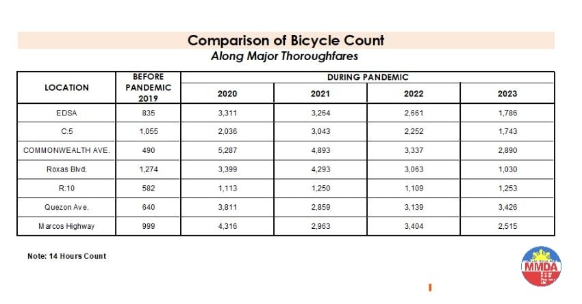
These are supposed to be official data as it is issued by the government agency in-charge of traffic management for Metro Manila roads (aside from its other functions and roles). What are not stated, and are actually very important details, are the locations of the counts and when the counts were conducted. The Traffic Engineering Center (TEC) that was under the DPWH and currently with the MMDA used to publish traffic volume maps for major roads in Metro Manila. So along EDSA, for example, the volume per section are shown on the map. The same for other major roads like Commonwealth, Quezon Avenue and SLEX. The thicker lines mean higher volumes along those sections, and vice versa. However, they did not consciously count bicycles (only motor vehicles) and perhaps MMDA only started counting during the pandemic (i.e., 2020). So there is no one value to represent a road. And counts vary over time of day, day of the week and even throughout the year (i.e., monthly variations).
There were many reactions to the MMDA’s posting of the data and most were critical and even derided the agency for what to them appeared to be inaccurate data. The problem is that it seems there are no other counts that can validate and perhaps refute the MMDA data. Previous bike counts were not conducted according to how the MMDA and DPWH count vehicles. That is, counts are typically done over a 14 or 16-hour period and ideally on several days in a year. Expansion and conversion factors are applied based on established stations along major roads that are supposed to have more frequent if not continuous counts. This methodology is how Annual Average Daily Traffic (AADT) is computed. Call it car-centric if you like but the methodology is very much applicable to bicycles as well. Peak hour counts for bikes are not enough and the peak hour factor for motor vehicles does not apply to bicycles (if this is to be used to expand/convert peak volumes to daily values). In fact, if you go into the math, there should be a peak hour factor for each type of vehicle considering each vehicle’s volume will vary differently over time. So yes, the solution here is to conduct bicycle counts according to how MMDA or DPWH counts vehicles and these should be done along several stations along major roads (e.g., those in the table above) to validate the MMDA counts.
More on this topic in the next post!
–
Planning for Accessibility: Proximity is More Important than Mobility
Here is a quick share of another very informative article that discusses the importance of proximity and more dense development in order to reduce car dependence.
Source: Planning for Accessibility: Proximity is More Important than Mobility
Here are some excerpts from the article:
“This shows that proximity is much more important than mobility in providing accessibility: location, location, location. For the last century, our transportation planning practices have contradicted this principle. Transportation agencies built urban highways that destroyed and degraded accessible and multimodal neighborhoods to benefit suburban motorists. This was racist and classist, but the mechanism was the way that transportation planners valued increased traffic speeds, measured as travel time savings, while ignoring the loss of accessibility imposed on urban neighborhood residents.
Of course, many other factors affect people’s transportation and neighborhood preferences. Some people need their cars for work or after-work activities, and not everybody can bicycle or use transit even if it is available. However, surveys such as the National Association of Realtor’s National Community Preference Survey indicate that many people would prefer living in more compact, walkable neighborhoods than they currently do but cannot due to a lack of supply.”
Such articles are a must read for those who want to understand why government needs to invest in land at or near the CBDs, and develop that land so people will not need to reside far from their workplaces and schools. Truly, there are many other factors affecting transport preferences or mode choice. Housing is one such factor that we continue to treat separately from transport. It is very (prohibitively) expensive to buy or rent in the city particularly in or near the CBDs. The result is people opting to purchase or rent homes in the suburbs. It doesn’t help that developers are also actively promoting subdivisions there and therefore are contributing to sprawl that puts so much pressure on transportation systems.
–
Article share: on subsidies to public transportation
Here’s a nice article that presents arguments for subsidies to support transit or public transportation:
Wilson, K. (February 5, 2024) “Study: Subsidizing Transit Actually Makes It More Efficient,” Streets Blog USA, https://usa.streetsblog.org/2024/02/05/study-subsidizing-transit-actually-makes-it-more-efficient [Last accessed: 2/18/2024]
Subsidies to public transportation can be quite tricky and may require quite a balancing act. There seems to be few options outside of the straightforward subsidies national and local governments in the Philippines provide. Rail transit, for example, is heavily subsidized but these are rare for road-based public transportation. The concept of service contracting has been considered but it also has a few variations. While there seems to have been a proof of concept tested during the pandemic, it required so much funds that government apparently lost interest (i.e., the funds were also needed by other sectors). Local governments meanwhile, or at least those that had resources, decided to operate their own public transport (e.g., Quezon City bus).
To quote from the article:
“Newmark’s study doesn’t definitively determine why, exactly, high subsidies seem to correlate with better efficiency and transit agencies collecting more fares, but he has some theories. Some systems, he says, use subsidies to increase service frequency or install dedicated lanes to speed routes up along heavily-utilized corridors — and riders are responding, predictably, by showing up in droves. (Route expansion can help, too, he said, but only if agencies expand service to places “where there’s actual demand.”) Others use subsidies to keep ticket prices low, but not to eliminate fares outright, which Newmark argues is a smart move.
“People value stuff they pay for, and they pay for stuff they value,” Newmark added. “An underlying point in this paper is that transit offers something [valuable], and it’s worth trying to capture that value, whether through fares or in other ways.”
If transit networks and the taxpayers who support them can get that recipe right, it could create a virtuous cycle.
“If people see the benefits [of subsidies], that may make them more willing to invest [their taxpayer dollars],” he adds. “Good transit leads to a real social movement for more subsidies.” “
What do you think about subsidies to public transport in the Philippine setting? Of course, we are referring to ‘formal’ public transportation here. There are many ‘informal’ or paratransit modes like tricycles and non-motorized pedicabs. There are also motorcycle taxis providing services or filling in the gaps in transport services.
–
