
Home » Posts tagged 'campus'
Tag Archives: campus
UP’s University Avenue
A week ago, I was invited to witness the renewal of a Memorandum of Understanding (MOU) between UP Diliman and a leading and prominent engineering company. I think one of the highlights of that event was getting to go to the Board of Regents meeting room at the top of Quezon Hall. This used to be an open area that we went to during our college days. The only times the place was off limits was when there were important meetings at Quezon Hall (e.g,, meetings of the UP Board of Regents) and during commencement exercises. It has been transformed into an air-conditioned facility that now hosts offices and this conference room. What’s the transportation thing in this post is the magnificent view of the University Avenue, which is the main gateway to the campus.
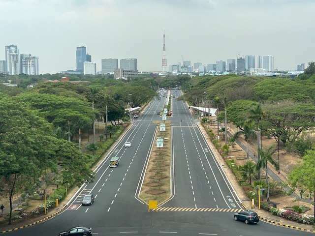 UP Diliman’s University Avenue as seen from the top of Quezon Hall
The University Avenue has also evolved as it now features bike lanes along each direction of the road. There are walkways that also served as bike lanes along either side of the avenue. These are visible in the photo and are protected, exclusive ROWs from the main travel lanes that used to be assigned to motorized traffic. The avenue connects UP’s Academic Oval, its campus core, to Commonwealth Avenue. I remember splendid sunsets viewed from the same vantage point as this generally faces the west.
–
Why College Campuses Make Ideal Models for Cities
I recently read this article on college campuses being models for cities. Of course, this refers to campuses or perhaps university towns that have developed in the US. These appear to be microcosms of cities or what cities should be. I can imagine this for the UP Diliman and UP Los Banos campuses. There are others that are similarly structured but most universities and colleges in the Philippines may not even have full campuses like UP including those in the University Belt in Manila. Many are practically just buildings. Others that have land like UST and Ateneo do not have the residential areas like UP’s that would make the campus a town in itself.
To quote from the article:
“Universities and other educational institutions make the lives of their students easier by placing amenities close to student housing so they can travel on foot or by bicycle to reach their destinations. This design encourages human interaction and improves quality of life.
The same can be done for cities and towns. Urban planners can look to college campuses for inspiration, borrow the features that enable this lifestyle, and incorporate them into city design. Such a holistic approach will make it preferable to travel on foot, make sustainable transport more accessible, and create thriving local economies.”
Traffic congestion at the UP Diliman campus
The University of the Philippines returned to face-to-face classes last week. That meant many students who have been admitted to the various programs of the university finally set foot on campus. Many, unsurprisingly, drove their own cars or were driven by their parents who themselves may probably were first-timers on campus, too. And given that many students come from middle to upper class families (they are the ones coming from the better schools and more likely to be admitted to UP), it is not surprising that many if not most have cars. The result is vehicles going around the campus even for short trips that could have been made by walking or cycling. Public transportation in the form of jeepneys were also affected as their routes were clogged by private cars. Jeepney users ended up similarly caught in traffic.
The same week, the UP Fair was also held. This was the first UP Fair in 2 years after the lockdowns. The trips generated by activities associated with the Fair contributed to the congestion along the main roads in the campus core. Note that much of the Academic Oval remained closed to traffic and these roads are the widest on campus. Still, portions were open to general traffic including sections to access the parking lot across from Palma Hall.
Will this congestion persist or will it go away eventually? Are a significant part of this actually through traffic? We’ll know very soon for sure once students settle down and realize going around on their cars are not the way to travel around the campus.
–
[Updates on this later]
Bike lanes at the UP Diliman campus – Part 1
I had first read about the enhanced bike lanes at the UP Diliman Academic Oval last month from a social media post of a friend. She was present as the delineations of the jogging and cycling lanes were being painted along with the baybayin marks distinguishing UP’s bike lanes from others like it. UP’s bike lanes predate the current ones around Metro Manila that mostly popped-up during the pandemic.
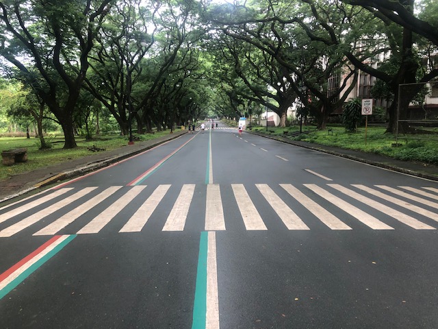 The Academic Oval road original had two-way traffic along its wide carriageway, that could easily fit 4 lanes. Since it became a one-way, counterclockwise road, the lanes had been divided into 3 wide lanes with one lane initially committed to bicycles.
 Here are the two lanes designated for joggers/walkers (curbside) and cyclists (median). The pedestrian sidewalk was originally planned to be widened in time for UP’s Centennial celebration back in 2008. That did not materialize. The Academic Oval could have had wider sidewalks for those who are not walking for exercise.
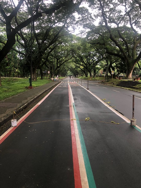
 The section in front of Melchor Hall features the words bicycles or bike lane and pedestrian in baybayin. Its certainly a novelty for now and something probably apt for the campus roads but not necessarily for others.
 A closer look at the baybayin script along the jogging/walking and bike lanes.
 Here’s the bigger picture on the pavement markings.
 Approach to an intersection
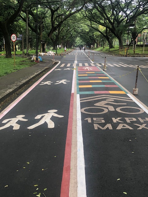 The UP colors inform riders about the intersection ahead. These are more visual as they are flat and not rumble strips. The older pavement markings advising riders of the speed limit should be seen in the context of utilitarian cycling (e.g., bike to work, bike to school) rather than cycling for fitness or recreation, which obviously may involve higher speeds and is frowned upon along the oval.
 The intersection approach from another angle.
The Academic Oval bike lane is one of the original recommendations of a transport study conducted for the campus about 17 years ago. The study was the basis for the campus being declared as a road safety zone, which among others included a provision for its roads to have a 30-kph speed limit. The one-way counter-clockwise traffic circulation and the jogging and bike lanes, however, are officially a part of what has become a long-term experiment on campus. There are many who oppose the one-way scheme and are vehement against the ultimate plan to have the Academic Oval car-free or car-less (it is mostly car-less during Sundays – part of the “experiment”).
The other new bike lanes on campus in Part 2 of this series.
–
