
Home » Posts tagged 'complete streets'
Tag Archives: complete streets
Article share: Why Complete Streets Design Benefits Everyone
Here is another quick share of an article; this time on Complete Streets. I guess many are aware of the AI-generated street transformations that are now being shared across many social media platforms. These show street transformations of many sections and intersections.
Source: Why Complete Streets Design Benefits Everyone
Again, it is important to have context sensitive solutions. This extends to street transformations. Some may look cool (AI tools have enabled non-architects, non-engineers, etc. to produce nice renderings) but should be tempered for the street or highway functions as well as the actual volume of people and vehicles running along these.
–
On street transformations using AI
My social media feed is full of images generated by artificial intelligence (AI). The street transformations are generated using a variety of AI tools. I’ve tried Canva and Gemini in producing similar images of street transformations; an exercise I’ve included in my undergraduate and graduate classes for more than a decade now but using their sketching and software (CAD, Sketch-up, etc.) skills to do the transformations. The photos below show an example of transformation along the University of the Philippines Diliman Academic Oval using Google Gemini.
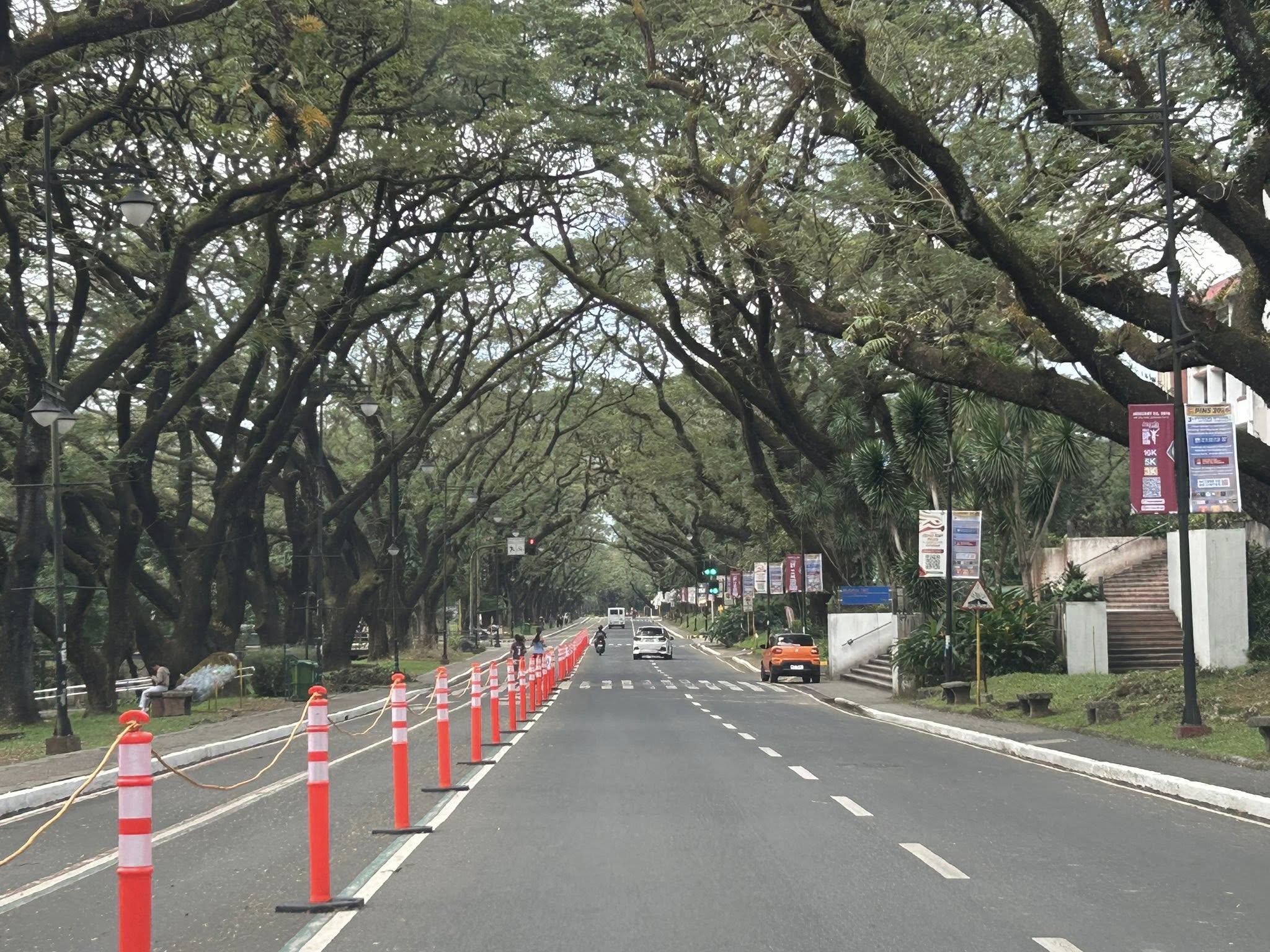 The original photo I took at the UP Academic Oval
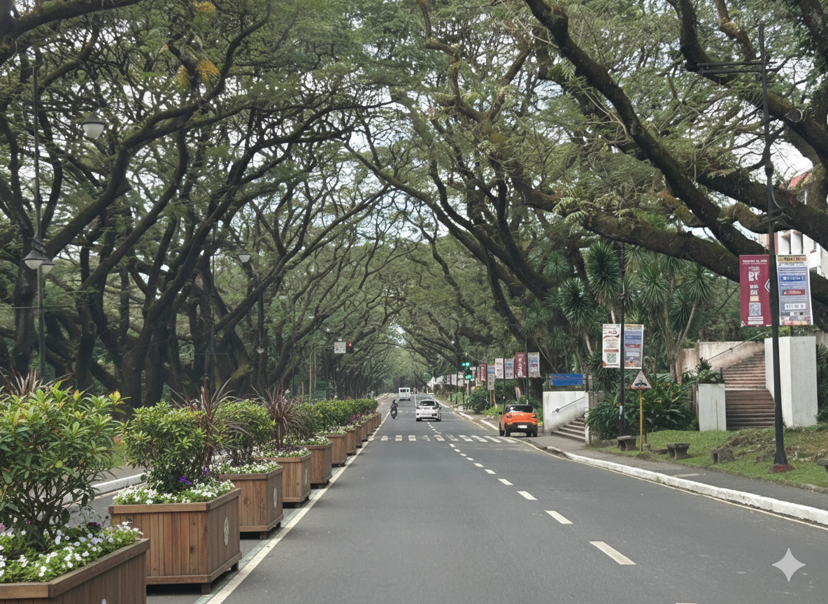
 The first attempt at replacing the orange bollards/barriers with something that blended with the campus.
 The second attempt showing plant boxes instead of the fence in the previous photo.
I think it’s possible to have excellent transformations of whatever roads or streets there are. One just needs to prompt or instruct the AI well enough to obtain these alternative designs. While the transformations are nice though, context is still important. Many of the transformations circulating on social media call for almost all major streets to be transformed. (Kulang na lang pati expressway gawan ng transformation.) Advocacy is good but context-sensitive solutions require a more constructive and cooperative. It certainly can do without being combative or antagonistic.
–
On understanding road diets
I’ve written and shared articles on road diets and complete streets before. Here is another article share on road diets
Johnson, R. (April 21, 2025) “Explainer: What is a Road Diet – And Why Should Cities Embrace It?,” Momentum Magazine, https://momentummag.com/explainer-what-is-a-road-diet-and-why-should-cities-embrace-it/ [Last accessed: 22/04/2025]
To quote from the article:
“The road diet isn’t about punishing drivers. It’s about creating streets that work better for everyone—from the parent pushing a stroller to the teenager biking to school, the delivery driver navigating a tight urban corridor, or the senior walking to the store.
As our cities continue to evolve, road diets offer a cost-effective, data-backed, and scalable way to make them safer, cleaner, and more livable. It’s not just about losing a lane—it’s about gaining a better future for urban mobility.”
Indeed, the first thing that usually comes to mind of motorists whenever road diets and complete streets are mentioned is that the road space (and consequently capacity) will be reduced. This reduction of capacity is actually from the perspective of the motor vehicle rather than the number of people traveling along a road as well as improving road safety for all. The article is spot on in its discussion on the resistance to road diets (and complete streets). Of course, context is very important here and it is important to identify which roads can be transformed for the transformation to be most effective.
–
On trees as solution to many of our urban problems
I am sharing this nice article on trees being the solution to many of our urban problems. I think many people have come to notice the importance of trees and the role they play with the increasing temperatures (i.e., heat) we’ve experienced the past years. The science on this state much more and covers not just temperatures but flooding, energy and infrastructure as well. Discussions and examples on these are in the article:
Durand-Wood, E. (August 8, 2024) “The Multi-Tasking Marvel: How Street Trees Can Solve Many Municipal Problems,” Strong Towns, https://www.strongtowns.org/journal/2024/8/8/the-multitasking-marvel-how-street-trees-can-solve-many-municipal-problems [Last accessed: 8/28/2024]
To quote from the article:
“Planting and maintaining street trees is an investment, but it’s one that pays for itself over and over again. Cities around the world are starting to calculate the economic value of their urban forests, a task made feasible with tools like i-Tree.
And more research is finding that trees pay for themselves many times over. A U.S. Forest Service study “conducted in five U.S. cities found that every dollar invested in the management of urban trees [ …] yields annual benefits of $1.37 to $3.09.
Trees are also the perfect example of a small bet. They cost relatively little, but the many varied returns are so high.”
–
On reimagining our streets
We start the last month of the year by sharing this article on complete streets:
Robertson, D. (November 15, 2023) “Safe streets are global—and it’s time for the U.S. to catch up,” Smart Growth America, https://smartgrowthamerica.org/safe-streets-are-global-and-its-time-for-the-u-s-to-catch-up/?eType=EmailBlastContent&eId=03b04320-4eeb-4bf5-9b12-71ec2a960421 [Last accessed: 12/1/2023]
To quote from the article:
“The examples mentioned here are exemplary cases, but demonstrate that the future of mobility need not follow the same dangerous status quo. They prove that with a combination of public and political will to the commitment of the prioritization of people over cars, we can produce the results we care all about.”
While the article is on complete streets, there is a very quotable section that referred to the situation in Japan:
“Anyone who wants to register a car in Japan today must prove that they have a private place to park it. This shifts the economic burden of providing parking from the public to drivers, and also ensures that supply of parking will not grossly outpace demand.”
There are many opportunities for the complete streets concept to be applied in the Philippines. A few have already been implemented but there should be more especially in light of the gains from the development of bike lanes networks in many LGUs that started during the COVID-19 pandemic. As for parking, perhaps the Japanese example should be adopted and implemented to curb car-dependence.
–
Article share: What’s Incomplete About Complete Streets?
The concept of road diets circulated in Metro Manila more than a decade ago. I recall the Metro Manila Development Authority (MMDA) picked up the concept and attempted to apply it in some parts of Metro Manila. Since there are no evidence of that endeavor surviving now, then we can assume that it was a failure. There is no wonder there as I also recall the effort to be half-hearted and more to get media mileage (cheap talk or lip service) out of it. Road diets eventually evolved into the complete streets (though the literature now will state road diets as part of complete streets). That experience and similar initiatives of varying success (or failure) rates are not unique to the Metro Manila but is actually happening elsewhere including cities in countries where the complete streets have been applied more comprehensively and yet somehow found to be lacking or not as effective a solution as expected. I am sharing an article here that discusses what seems to be lacking or ‘incomplete’ as it is referred to.
Source: What’s Incomplete About Complete Streets?
Quoting from the article:
“What’s missing? First of all, even the best Complete Streets policy can’t solve the problem of fiscal scarcity. Even in a city committed to Complete Streets, street redesign must fight for public dollars with other worthy goals such as education and public safety. As a result, Indianapolis’s improvements are a drop in the bucket. The city maintains 3,400 miles of streets and roads, so its 100 miles of bike lanes affect only 3 percent of the city. Similarly, 2,000 miles of the city’s roads still lack sidewalks.
Second, the quantitative benchmarks seem to focus on sidewalks and bike lanes (Sec. 431-806), and the policy doesn’t mention traffic calming or similar policies. So if the city had a six-lane road with traffic going 60 miles per hour, the Complete Streets policy would not affect that road except to the extent necessary to build a sidewalk or a bike lane.** Thus, even the best Complete Streets policies don’t really address some of the most dangerous features of American street design.”
—
Cool Walkability Planning
I am sharing this article about planning and design for more walkable streets. The term ‘cool’ in the article refers to temperatures as people are less likely to walk if it is too hot to do so.
From the article:
“Improving walkability (including variants such as wheelchairs, hand carts, low-speed scooters) can provide significant benefits to people, businesses and communities, particularly in dense urban areas where land values are high and vehicle travel is costly. However, walking can be uncomfortable and unhealthy in hot climate cities, particularly those that often experience extreme temperatures (over 40° Celsius, 105° Fahrenheit). These conditions make walking unattractive and infeasible during many days…
A well-planned networks of shadeways (shaded sidewalks) and pedways (enclosed, climate-controlled walkways) incorporated into a compact urban village can provide convenient, comfortable and efficient non-auto access during extreme heat. They can create multimodal communities where residents, workers and visitors rely more on walking and public transit, reduce vehicle use, save on vehicle costs, and require less expensive road and parking infrastructure…
The main obstacle to comprehensive pedway development is the well-entrenched biases that favor motorized travel and undervalue non-motorized modes in transportation planning and investment. Transportation agencies have tools for planning and evaluating roadway improvements, and funding to implement them, but lack comparable tools and funding for walkability improvements such as shadeways and pedways, even if they are more cost effective and beneficial than roadway projects.”
Source: Cool Walkability Planning
Article share: Redesigning Streets for Livability: A Global View
I am sharing this article on redesigning streets. It is actually a promotion for a book: “Streets For All: 50 Strategies for Shaping Resilient Cities”.
To quote from the article:
“Streets For All: 50 Strategies for Shaping Resilient Cities is an expansive 270-page volume that explores the evolving potential of the most ubiquitous public space in our cities. It offers ideas, tactics and strategies from across the world on how our streets are being, and, can be rethought, recast, repurposed and redesigned towards greater resilience and resourcefulness. The globally diverse opinions and case studies in this book remind us why cities with limited means can offer profound lessons to affluent societies that take their prosperity for granted. And in turn, how the virtues of effective urban administration and reinforcement seen in developed societies could reassuringly serve to inspire less economically developed ones.”
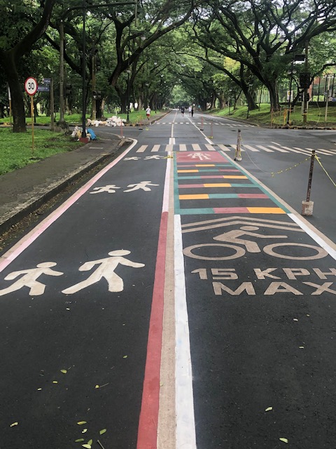
Bike lanes at the UP Diliman campus – Part 1
I had first read about the enhanced bike lanes at the UP Diliman Academic Oval last month from a social media post of a friend. She was present as the delineations of the jogging and cycling lanes were being painted along with the baybayin marks distinguishing UP’s bike lanes from others like it. UP’s bike lanes predate the current ones around Metro Manila that mostly popped-up during the pandemic.
 The Academic Oval road original had two-way traffic along its wide carriageway, that could easily fit 4 lanes. Since it became a one-way, counterclockwise road, the lanes had been divided into 3 wide lanes with one lane initially committed to bicycles.
 Here are the two lanes designated for joggers/walkers (curbside) and cyclists (median). The pedestrian sidewalk was originally planned to be widened in time for UP’s Centennial celebration back in 2008. That did not materialize. The Academic Oval could have had wider sidewalks for those who are not walking for exercise.
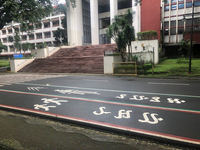
 The section in front of Melchor Hall features the words bicycles or bike lane and pedestrian in baybayin. Its certainly a novelty for now and something probably apt for the campus roads but not necessarily for others.
 A closer look at the baybayin script along the jogging/walking and bike lanes.
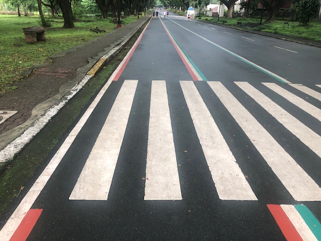
 Here’s the bigger picture on the pavement markings.
 Approach to an intersection
 The UP colors inform riders about the intersection ahead. These are more visual as they are flat and not rumble strips. The older pavement markings advising riders of the speed limit should be seen in the context of utilitarian cycling (e.g., bike to work, bike to school) rather than cycling for fitness or recreation, which obviously may involve higher speeds and is frowned upon along the oval.
 The intersection approach from another angle.
The Academic Oval bike lane is one of the original recommendations of a transport study conducted for the campus about 17 years ago. The study was the basis for the campus being declared as a road safety zone, which among others included a provision for its roads to have a 30-kph speed limit. The one-way counter-clockwise traffic circulation and the jogging and bike lanes, however, are officially a part of what has become a long-term experiment on campus. There are many who oppose the one-way scheme and are vehement against the ultimate plan to have the Academic Oval car-free or car-less (it is mostly car-less during Sundays – part of the “experiment”).
The other new bike lanes on campus in Part 2 of this series.
–
Where do trucks fit in complete streets?
The complete streets concept usually involve transforming streets to favor active and public transport. The typical discussions and presentations on complete streets are often focused on taking away road space from cars to allocate to pedestrians (e.g., wider sidewalks), cyclists (e.g., bike lanes) and public transport (e.g., transit lanes). Seldom do we read about trucks, deliveries and related items even in guides and manuals and are often just implied to be addressed in street transformation examples.
Evans, T. (March 24, 2022) “”Complete Streets” and Goods Delivery: What are Streets For?” New Jersey Future, https://www.njfuture.org/2022/03/24/complete-streets-and-goods-delivery-what-is-a-street-for/ [Last accessed: 4/5/2022]
To quote from the article:
“Not every final destination for a package needs to be accessible to large trucks. Rather than proposing truck-focused modifications (wider lanes, bigger turning radii, etc.) to local streets in order to accommodate truck deliveries, transportation planners and logistics industry professionals should focus instead on matching the type of delivery vehicle to the environment in which the destination is located.”
I recall the mainly pedestrianized shopping streets (shotengai) in Japan when I try to make sense of how delivery vehicles can be included in the discussion. The Japanese use small trucks or vans for deliveries and mostly these are confined to the side streets. However, during certain times of the day, usually early mornings or after business hours, they are allowed inside the shopping street for quick deliveries or pick-ups. This show what kind of goods vehicles and operations may be permitted.
–
