
Home » Posts tagged 'EDSA'
Tag Archives: EDSA
After getting engrossed with EDSA, is Marcos Highway next?
If you monitored the news articles and social media post over the past two decades, there seems to be an obsession for EDSA. Circumferential Road 4 is the busiest corridor in Metro Manila, stretching across several jurisdictions including Caloocan, Quezon City, Mandaluyong, Makati and Pasay City. Aside from the MMDA, national agencies like the DPWH and DOTr have been heavily involved in traffic schemes and transportation infrastructure development along the corridor. These include variants of the travel demand management (TDM) scheme commonly called number coding. Since the 1990s, there’s the Line 3 and several overpasses/flyovers and underpass that have been constructed along major intersections (e.g., EDSA-Shaw, EDSA-Ortigas, EDSA-Kamuning, EDSA-Quezon Avenue, etc.). Nowadays, people are more into the EDSA carousel and most recently the pavement rehabilitation for EDSA. It seems we failed to realize that EDSA is just one corridor. There are others that also demand attention including those in other parts of the country.
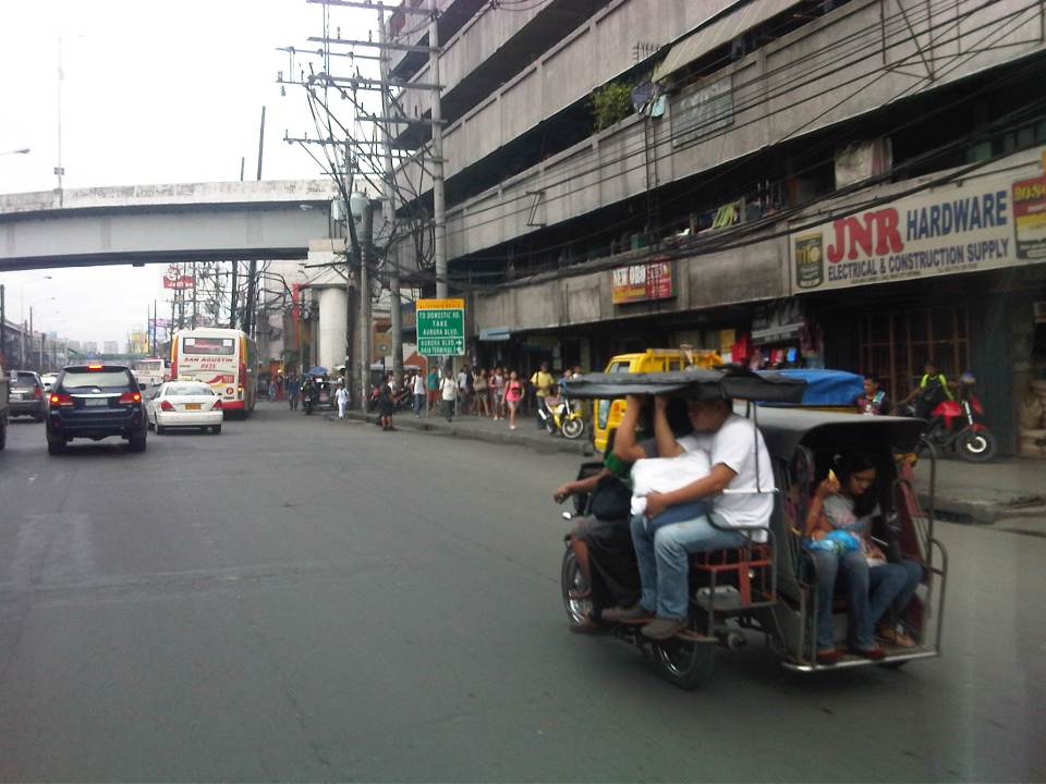
Recently, a “carmaggedon” along Marcos Highway was in the headlines or shall I say was trending in social media. There was a lot of excitement for what has been a recurring nightmare to those residing along the corridor. I recall something worse occurred more than 15 years ago (pre-Ondoy), before social media and influencers and digital creators. At the time, Line 2 terminated at Santolan Station. And even back then, the MMDA insisted on playing with their U-turn scheme. I don’t recall a more in-depth study that could have involved micro-simulation modeling being done for the corridor. And since then, populations and traffic have grown steadily and as I’ve written about previously, the extension of Line 2 to Masinag seems to have had little impact on traffic. And so here we are with the MMDA still insisting on tweaking their U-turn schemes and relying mainly on gut-feel instead of a more scientific approach that may actually lead to more sound solutions for the corridor.
 Approach to Marcos Highway from Felix Avenue – that’s the elevated Line 2 superstructure behind the Cainta arch.
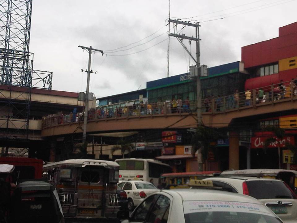
 Intersection of Marcos Highway, Felix Avenue and Gil Fernando Avenue – there’s a major foot bridge installed here so people can cross at the intersection, which used to be a signalized junction before the MMDA opted for U-turns for Marcos Highway sections under its jurisdiction.
 Marcos Highway section fronting the Ayala Feliz Mall – the MMDA has played with the location of the U-turn slots in the vicinity of the Marcos Highway-Amang Rodriguez-J.P. Rizal intersection as they tried to determine the “optimum” locations of these slots.
Of course, there is also the case of Commonwealth Avenue. How many carmaggedons have occurred along that corridor? Isn’t it an everyday thing there? And there’s also Ortigas Avenue Extension and many other roads and streets where congestion seems to have been accepted as the norm. How do we make travel easier for most people? How do we improve commutes given the constraints and realities concerning behavior and choices?
–
A widened Col. Bonny Serrano Avenue and opportunities for complete streets
Col. Bonny Serrano Avenue is one of the major roads directly connecting EDSA (C-4) and C.P. Garcia Avenue (C-5). The last time I used the road was before the pandemic. So it came as a surprise to pass by last weekend and see the avenue had been widened. I guess that pretty much “solved” the traffic along this usually busy thoroughfare that is part of jeepney routes to Cubao (via Murphy – referring to Camp Aguinaldo, which was formerly Camp Murphy). The avenue was renamed after a Korean War Hero (my uncle fought under him with the 10th Battalion Combat Team in the Korean War in the 1950s). It was called Santolan Road before.
 What used to be a 4-lane road is now an 8-lane road
The area used for road widening was carved out of Camp Aguinaldo. The headquarters of the Armed Forces of the Philippines (AFP) gave up quite a lot of square meters for this project and you can see from the photo the now very wide avenue. I thought perhaps they could have placed a median island where they could have also planted some trees (note how exposed to the sun the area is). They also could have designed protected bike lanes along either side of the road. These could have connected the EDSA and C5 bike lanes. And, of course, they should have also improved the pedestrian sidewalks. You can see how narrow the sidewalks are and how electric and light posts block pedestrians using the sidewalks. There were opportunities here for the application of complete streets and its not too late to do just that.
I assume there are many men in uniform who use bicycles for their commutes and recreation. Camp Crame is just across EDSA from Camp Aguinaldo and Bonny Serrano Avenue also passes along the headquarters of the Philippine National Police (PNP). Down the road towards Marikina City in Libis is another camp, Camp Atienza, which is home to the 51st Engineering Brigade of the Philippine Army. I mention these camps as I know many there regularly use Bonny Serrano for commuting and many use bicycles. A cousin-in-law (my wife’s first cousin) who is an army officer bikes a lot from Camp Atienza and Camp Aguinaldo and tells me there are many enlisted men who bike to work.
–
Some observations and thoughts about the EDSA carousel
Much has been written or said about the EDSA Carousel. This is the express bus service the government implemented along Metro Manila’s busiest thoroughfare, EDSA or Circumferential Road 4. I feel that it is a decent effort from government to address the lack of supply to address the huge demand for public transport along EDSA considering that it serves to also distribute trips collected from major roads connecting to it. Is it an admission of something wrong in terms of the transport infrastructure along EDSA? Perhaps and from the current administration and DOTr. The admission of flaws certainly did not or will not come from the previous administrations that failed to address problems pertaining to Line 3 including maintenance and operations issues.
 Buses queued before the Trinoma/North Avenue Station of the carousel. Overhead is the junction to the EDSA-MRT depot underneath Trinoma.
 The overhead junction is the MRT’s branch to/from the depot
 Buses queuing towards the North Avenue Station
 The carousel stations are basically part of the MRT station with the platform located at ground level at the otherwise underutilized space that is the median island of EDSA. Access to the express buses are via the MRT stations as there are no other means for crossing to/from the carousel berths.
The carousel is an attempt to have a Bus Rapid Transit (BRT) along EDSA. It is perhaps the most practical solution to supplementing the already limited capacity of elevated Line 3 despite the continued operations of regular buses. The express bus service is not a new idea along EDSA since Line 3 had to compete with a BRT proposal (though it didn’t use the term BRT then) back in the 1990s. Insiders at NEDA relate that it was then President Fidel V. Ramos himself who allegedly ‘lobbied’ for the MRT instead of an elevated bus transit system. Unfortunately, the MRT proposed, constructed and now in operation is a light rail system like Line 1 and could not easily be upgraded to a heavy rail system like Line 2 or the future Line 7. The line is already problematic due to maintenance issues and the aging rolling stock. And there are questions regarding interoperability with Line 1 (definitely not interoperable with Line 7). So the grand central station currently under construction will really be a terminus for 3 lines as trains will not be able to pass through to other lines like how it is in other countries.
Will the carousel be a permanent fixture along EDSA? Perhaps. But it should be improved further for the convenience of commuters as well as for more efficient operations. The current buses being used are the not the right vehicles if capacity is to be maximized. Articulated buses would be necessary for this purpose. The current barriers should also be replaced with more appropriate and perhaps more clever designs partly for aesthetics but for the system to be safer and more functional in terms of spaces for passengers and vehicles.
–
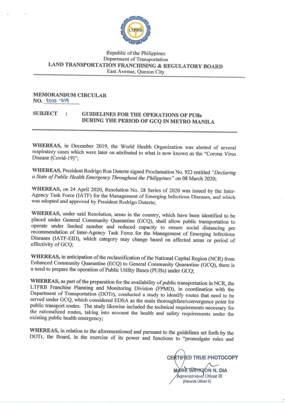
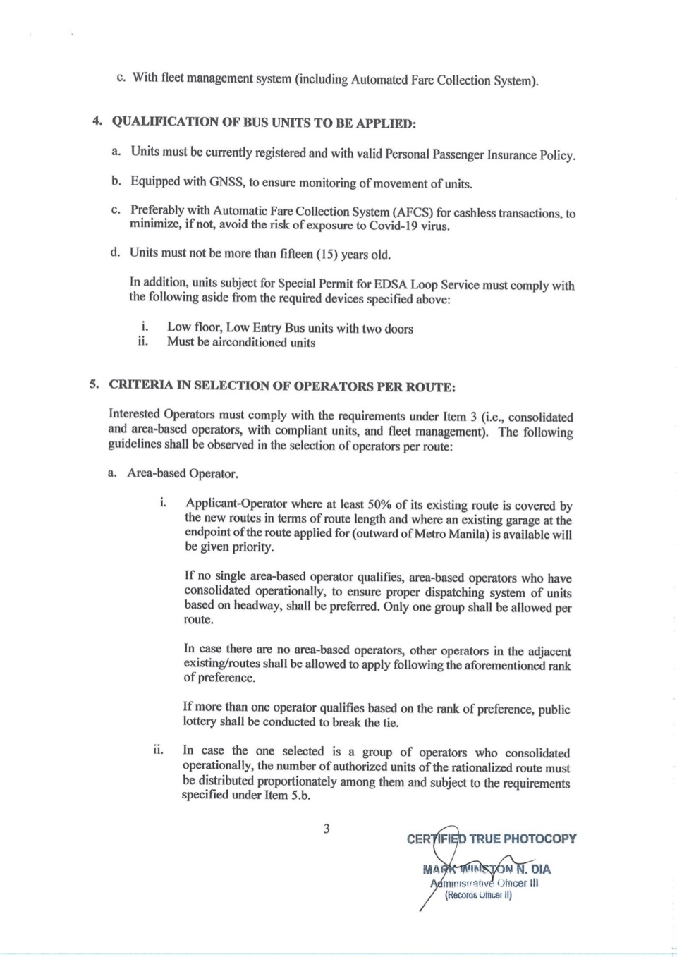
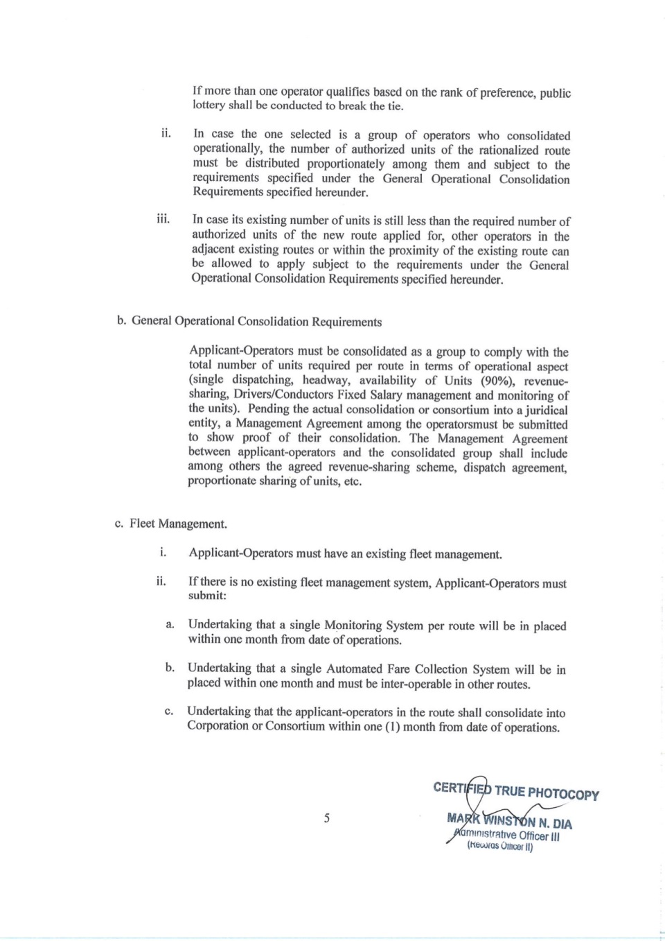
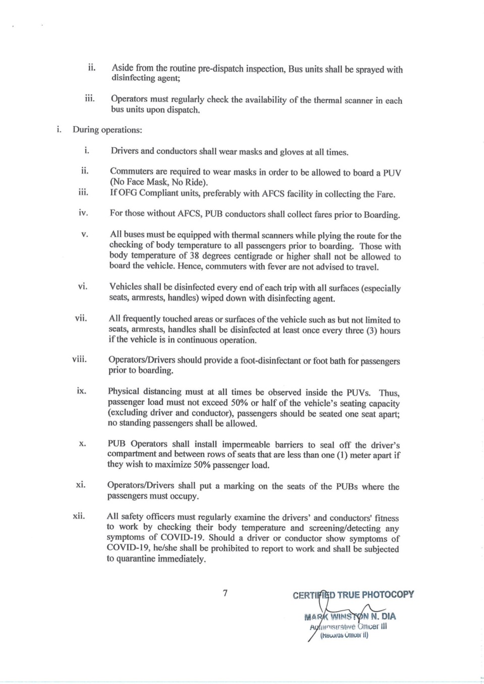
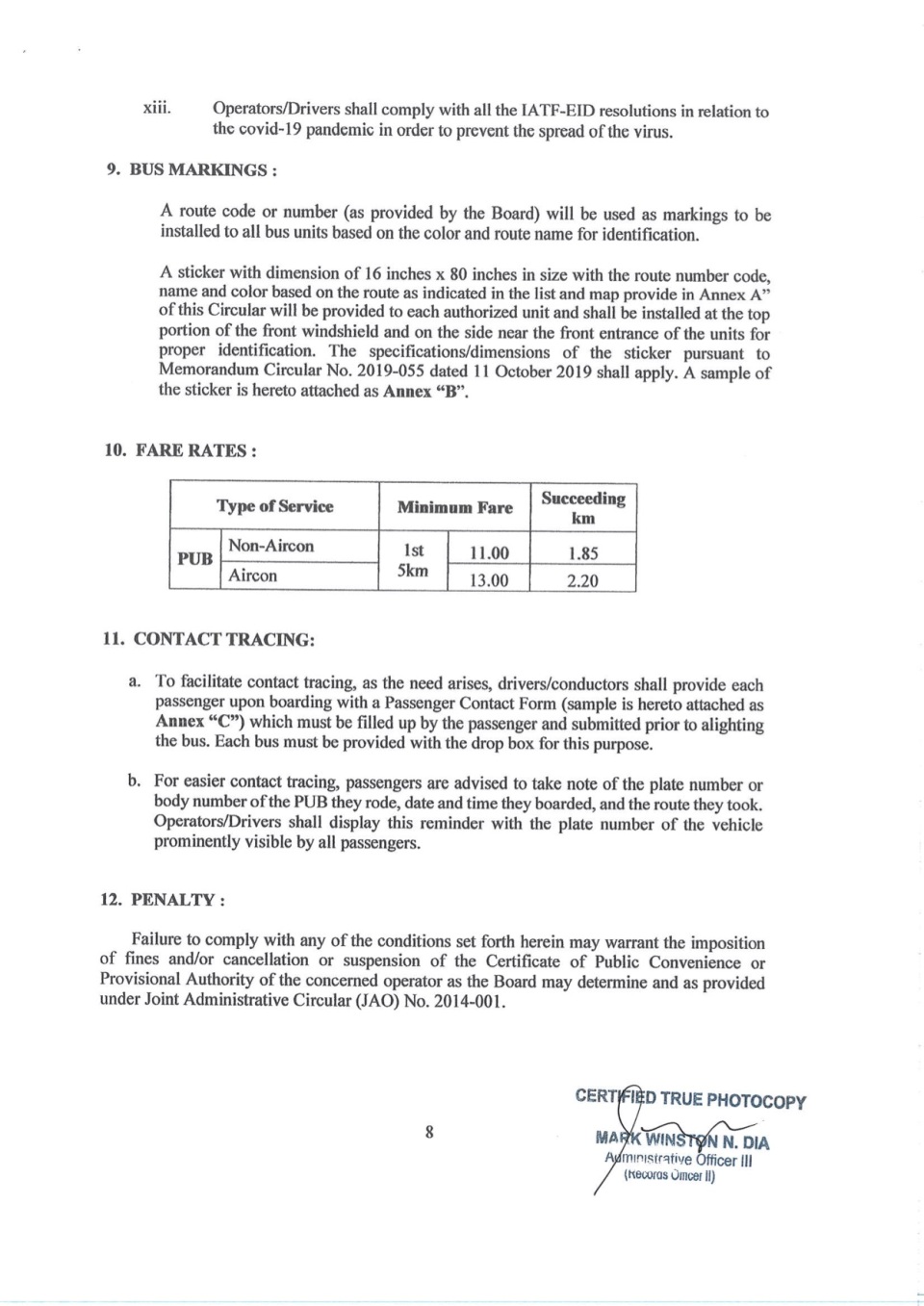
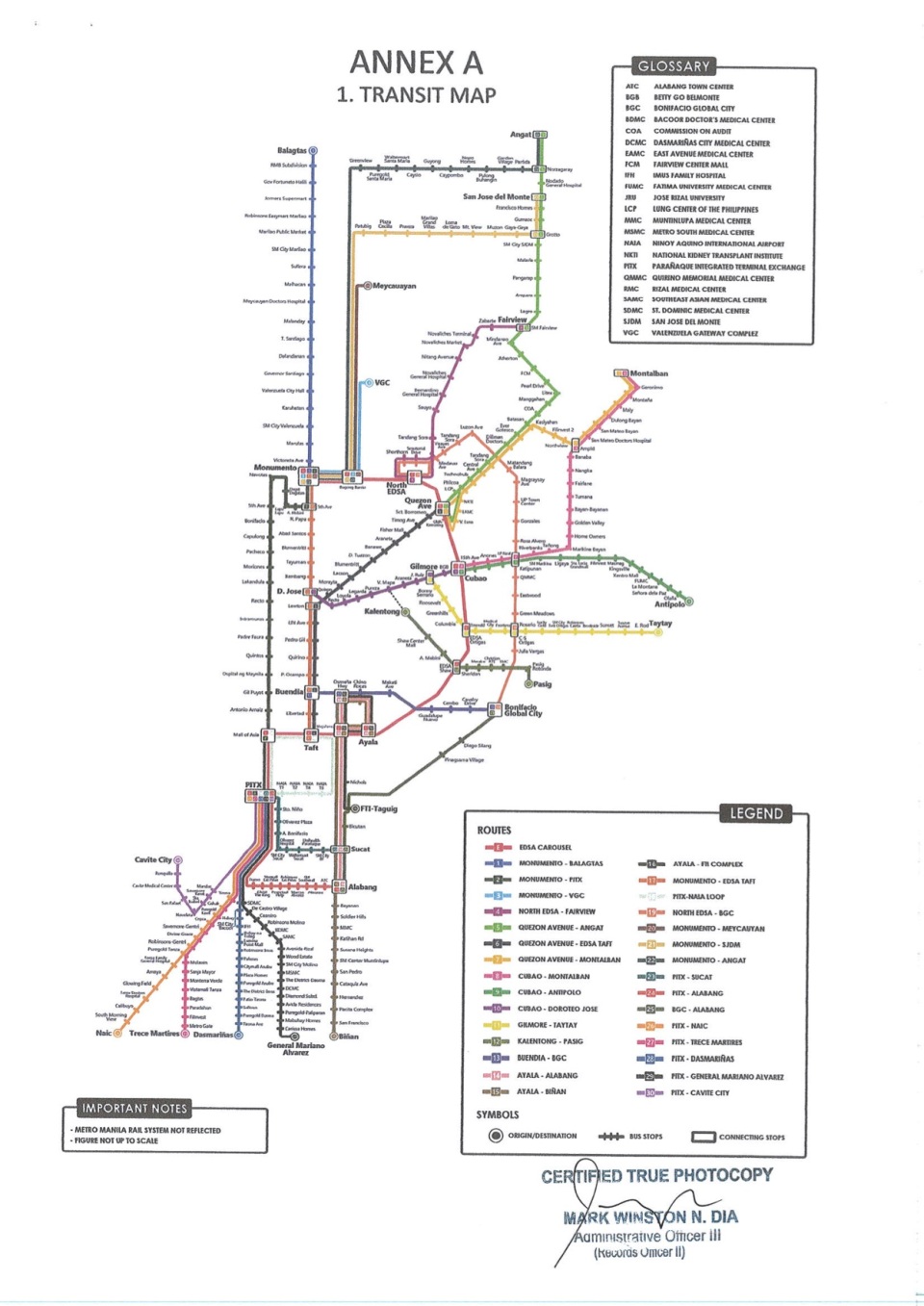
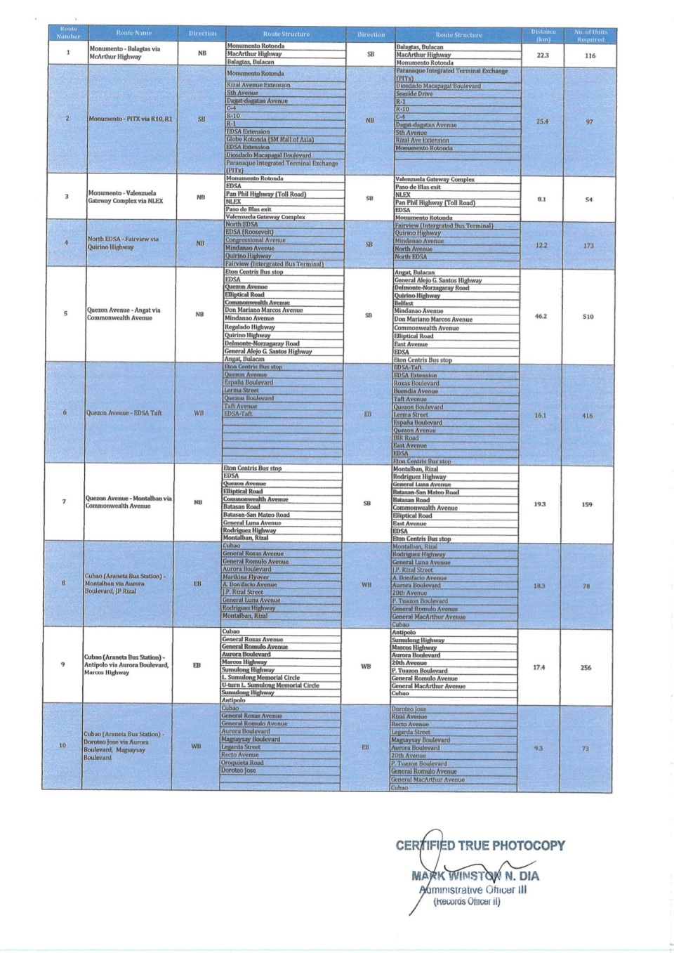
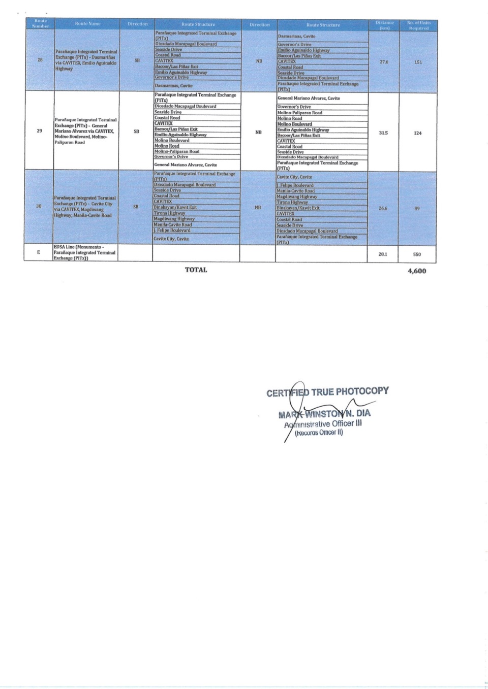
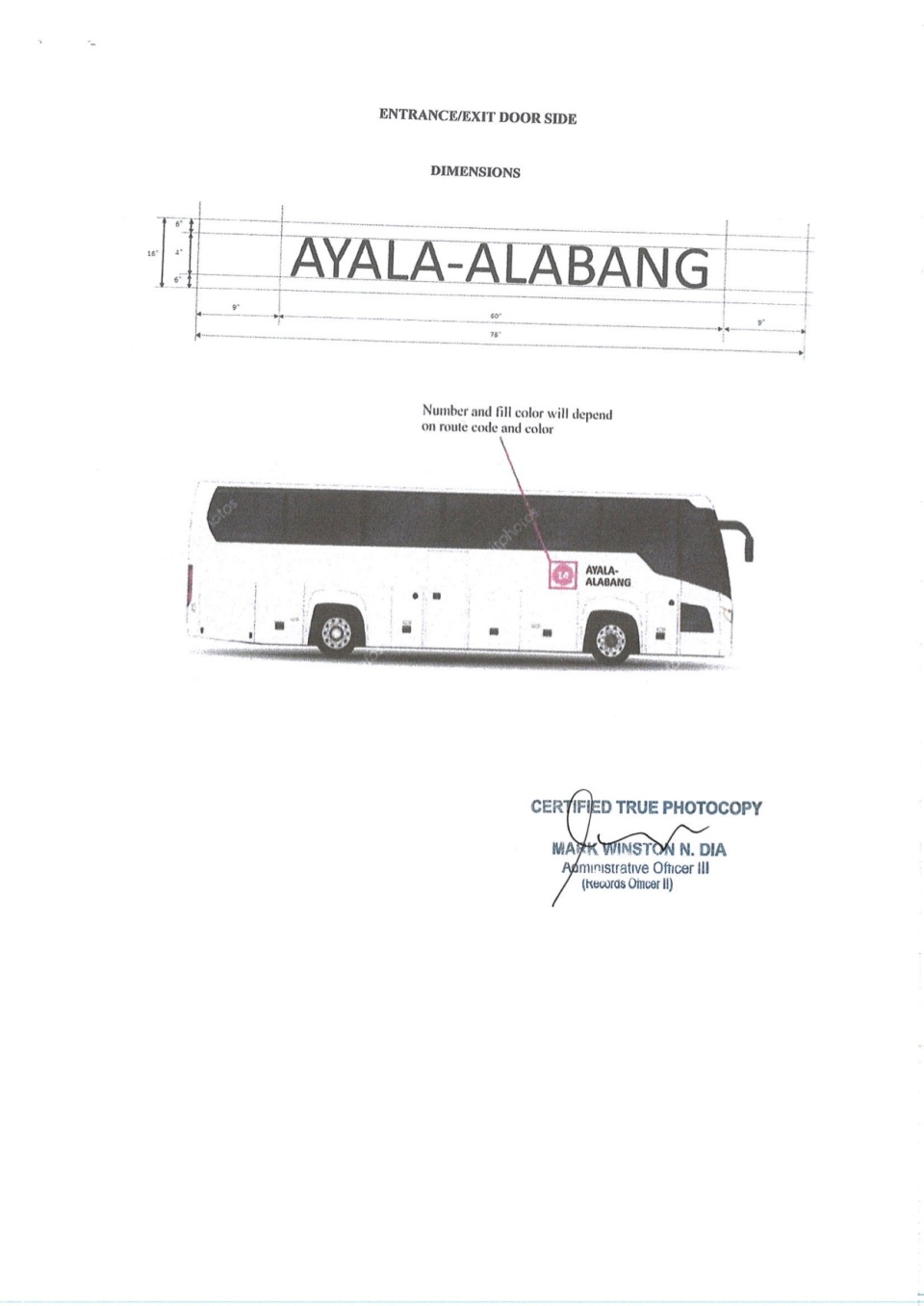
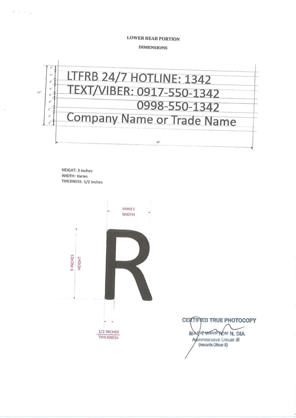
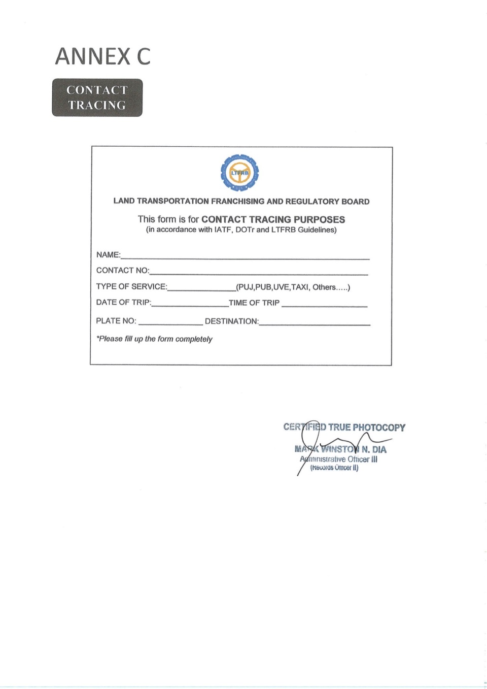
LTFRB Memorandum Circular No. 2020-019 – Guidelines for the Operations of PUBs During the Period of GCQ in Metro Manila
The following images show the full 19 pages of the Land Transportation Franchising and Regulatory Board Memorandum Circular No. 2020-019: Guidelines for the Operations of PUBs During the Period of GCQ in Metro Manila. Again, no comments for now as I post this for reference. I have not seen it posted on the LTFRB’s Facebook page yet but it is a public document and something that needs to be circulated for the benefit of the riding public.


–
On the unpredictability of EDSA traffic
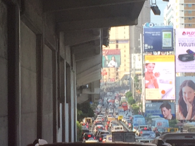
Much has been written about the traffic along EDSA, which is perhaps Metro Manila’s most famous (some would say infamous) thoroughfare. These include the unpredictability of congestion along this road. While it is hard to believe that traffic congestion is unpredictable for EDSA because very often it is congested, there are times when you just marvel that its free-flowing during the day or shocked that its packed with cars close to midnight. Last week, we experienced both predictability and unpredictability in the sense that we did expect EDSA to be congested near Ortigas (due to the dismissals of schools in the vicinity) but didn’t expect it to be packed during what we thought was “alanganin na oras” that was around 3PM.
 EDSA northbound traffic taken at Guadalupe last October 1, 2018 at 3:30PM.
Interestingly, there was no congestion after Ortigas Avenue and we quickly made up for the time lost in the congestion we experienced from Gil Puyat Avenue. Is this another case of the phantom congestion where the simple disturbances in the traffic stream can create a ripple effect resulting in congestion? Or is this somewhat like an everyday thing? EDSA is not part of my daily commute so I am not so sure about the regularity of this situation but at least the weather didn’t factor in the equation. Heavy rains usually lead to flash floods along this thoroughfare, and these floods will definitely lead intense congestion.
–
On EDSA transport and traffic, again
There’s a recent decision by the Metro Manila Council (MMC) comprised of the mayors of the cities and municipality of Metro Manila and chaired by the Metro Manila Development Authority (MMDA) Chair that vehicles bearing only one passenger (the driver) will be banned from travelling along EDSA. The problem with this is that by banning cars with one passenger from EDSA, you only succeed in making other roads like C5 more congested. It’s a simple case of transferring traffic and worsening it elsewhere since you’re not doing anything to alleviate congestion along those roads. Did MMDA run this and other scenarios using analytical or simulation tools at their disposal? If so, can these be shown and used to explain the soundness of this policy approved by the MMC? I suspect they didn’t and likely depended more on gut feel based on the data they have including what is often reported as 70% of vehicles traveling along EDSA having only one passenger. Meanwhile, the state of mass transit along EDSA still sucks.
 A very crowded Boni Avenue Station platform (photo courtesy of Mr. Raul Vibal)
Of course, the pronouncement from the MMDA launched quite a lot of memes on social media. Some people shared the typical quotes on planning (you know, like the ones about planning for people vs. planning for cars). Some offered their own ideas about how to “solve” traffic along EDSA. And so on…that only succeeded in showing how everyone had an opinion about transport and traffic. Everyone is an expert, so it seems.
Some thoughts and not in any order:
- The government can initially dedicate a lane each for express buses (a la Bus Rapid Transit or BRT). This idea has been circulating for quite some time now and has a good chance of succeeding. The DOTr is already deploying buses that they say are supplementing the MRT 3 trains (i.e., there aren’t enough trains running so passengers have the option of taking a bus instead). Running along the inner lanes of EDSA would mean, however, that they would have to find a way for passengers to cross the road and one idea would be for the stations to be retrofitted for this purpose.
- Those cars along EDSA are not necessarily for short trips so walking and cycling while needing space may have less impact in the immediate term for such a corridor. In the meantime, serious consideration should be made for bike lanes whether on the ground or elevated and improvements to walking spaces.
- But these efforts to improve passenger (and freight) flows should be a network-wide thing and not just along EDSA.
- It’s time to have serious discussions and perhaps simulations (even a dry run) of congestion pricing in Metro Manila. Congestion pricing for all major roads and not just one or two. Funds collected goes to mass transit, walkways and bikeways development. DOTr was supposed to have already discussed an Electronic Road Pricing (ERP) system like Singapore’s with the company and people behind the same in the city-state. That doesn’t seem to be moving along.
- Working and studying from home might work in terms of reducing vehicular traffic but then we generally have lousy internet services so that’s a barrier that needs to be broken down.
- How about legalizing, once and for all, motorcycle taxis? Many are opposed to this citing safety concerns but then we are running out of options outside the usual motherhood statements pertaining to building transport infrastructure. Think about it. Give it a chance. These motorcycles might just surprise us in a nice way; that is, helping alleviate congestion.
- Carpooling and lanes dedicated to High Occupancy Vehicles (HOV) would be good but the LTFRB made a pronouncement about these being illegal as they would be considered ‘colorum’. Such statements do not make the situation any easier and sends mixed signals as to the government’s being serious in considering all possible angles to improve transport and traffic particularly for commuting.
Do you have other ideas to share?
–
Some thoughts on Metro Manila traffic
I was going to defer posting another article this September as I reached my usual quota of at least 10 posts. Particularly, I wanted to have a series about my recent trip to Vietnam. But then the traffic congestion the past week was just so severe that I felt I just had to write another piece.
To be fair, there are so many reasons why transport and traffic are bad in Metro Manila. Among these is the lack of mass transit infrastructure, particularly a more comprehensive rail-based system. Metro Manila, with its population of over 12 million requires something like 8 to 10 mass transit lines that are interconnected and allows for seamless transfers with road transport modes. Singapore, with less people, has more efficient options for public transport. Then, there is the lack of facilities for walking and cycling that could tremendously reduce the number of trips using motor vehicles particularly for short trips (perhaps within 2 to 3 kilometers travel distance?). I won’t even go to the deficiencies of road public transport and the proliferation of private cars operating as full time taxis (ridesharing anyone?). And urban planning? Well, that deserves its own article…
 This is EDSA in the mid-afternoon. I took this photo while we were heading back to Quezon City from Makati around 3:30PM. It was not supposed to be this heavy considering people were still at their workplaces, schools or even the shopping center/malls.
There is no quick fix to Metro Manila’s problems. Obviously, the infrastructure that should have been in place decades ago need to be built albeit at a high cost. Our children and grandchildren will likely end up paying for these but there is also the reality that such infrastructure won’t get cheaper in the future. There should also be stricter policies and enforcement to improve the quality of services of public transport. As it is, private transport modes including taxis, the popularity of ridesharing/ridehailing services and the unregulated motorcycle taxis are steadily taking people away from public transport. This is perhaps among the most significant causes of more congestion for the metropolis that needs to be quantified and validated for us to understand and determine what measures need to be taken.
I conclude this post and September with a nice article on walkability:
Steuteville, R. (2017) Why walkability is not a luxury, Public Square, https://www.cnu.org/publicsquare/2017/09/28/why-walkability-not-luxury, last accessed September 29, 2017.
–
Proposals for EDSA and some alternate roads
The hellish traffic congestion along EDSA and other roads in Metro Manila spawned a bunch of ideas for alleviating congestion. Among those that were offered as solutions are the following:
- Odd-Even Scheme – suggested by the Philippines President himself in a speech delivered in Mandaluyong City
- Car-pooling (and HOV lanes) – suggested by the DPWH Secretary in another forum
- Bus Rapid Transit (BRT) and/or express bus – proposed and being studied by the DOTC
What seems to have been forgotten was a proposal to have two lanes of EDSA, one on either direction, devoted to bicycles. This proposal now seems to be the most viable compared to the above three and could have the potential for major behaviour change towards a departure from motor vehicle use. Cycling along with walking does not require fuel and these modes also promote healthy lifestyles. Also, this could become the ultimate example for road diets, which can also be applied along other roads as well. What sounds or reads like an outrageous idea (i.e., bicycle lanes along EDSA) might just be revolutionary and result in what could be a tipping point for sustainable transport in the midst of traffic mayhem.
EDSA has become the proverbial battleground representing the war with traffic congestion. However, EDSA is just one part of our arterial network comprised of circumferential and radial roads. There is also C-5 (also known for its sections – Katipunan, E. Rodriguez, C.P. Garcia), which is also a very congested road but along which there are few fixed route public transport services. It is a primary alternative route (to EDSA)for people traveling between the northern and southern halves of Metro Manila. It also serves as a collector and distributor, being connected with major radial roads like Aurora Boulevard, Ortigas Avenue and Shaw Boulevard as well as to the South Luzon Expressway. C-5 is a major truck route, however, and so carries a lot of heavy vehicles during the permitted times under the truck ban scheme being implemented in Metro Manila. C-5 is already ripe for a mass transit system and should have one along it. The quickest to put up would be a bus system on exclusive lanes. Strategically though, a rail transit line (likely elevated) should already be planned and implemented and with as seamless as possible connections to current and future lines along major corridors.
There are other routes that can be considered which I think have been overlooked (too much focus on EDSA?). C-6, for example, badly needs to be improved and this has started but is being implemented at a slow pace. This could have significant positive impacts on traffic coming from the east (towns of Rizal province) that are bound primarily for Makati and BGC. But then there also has to be a good road bypassing the narrow and already congested streets of Taguig and Pateros that are currently the only roads connecting C-5 and C-6. The roads on the Rizal side (attention: Cainta and Taytay) also need to be improved including Highway 2000 and the Barkadahan Bridge. Perhaps the Rizal Provincial Government should also get involved in this as such routes are in the best interest of Rizalenos. And then there is also the highly urbanized city of Antipolo that is a major destination and already is the 7th most populous city in the country, whose residents also use this route, which is often a faster option to Ortigas and C-5 despite the poor conditions of roads.
–
Consultation on EDSA decongestion – September 24, 2015
There will be a public consultation tomorrow entitled “EDSA Decongestion Consultation” at the GT Toyota Auditorium at the Asian Center of the University of the Philippines Diliman from 1:30 – 3:30PM. The consultation will tackle transport and traffic in Metro Manila but particularly along EDSA. The consultation will be facilitated by the TWG headed by Sec. Almendras who is the cabinet secretary put in-charge of addressing (solving?) the traffic mess in Metro Manila. The TWG includes DPWH, DOTC, DTI, MMDA, LTO, LTFRB, and the PNP-HPG.
This would be a good venue for stakeholders to articulate their concerns as well as offer their ideas towards alleviating transport and traffic problems. Invitations are supposed to have been extended to academic institutions, transport groups and other interested parties. Hopefully, this event will be a productive and constructive one. Pointing fingers and playing the blame game will not get us anywhere.
–
EDSA: Taft to Tramo
The EDSA-Taft Ave. intersection was in the news a few weeks ago due to the MRT3 train that derailed and overshot the end of the line along EDSA. Being a major intersection for roads as well as for rail (MRT3 and LRT1), it is a very crowded area. Nearby, too, is the Redemptorist church in Baclaran that attracts a lot of people especially during Wednesdays. Following are a few photos of the area showing the conditions on the pedestrian overpasses and at street level.
 The pedestrian overpass at EDSA-Taft is also a mall of sorts given the merchandise being sold at informal shops at the overpass.
 The overpass connects to the EDSA-MRT 3 Taft Ave. Station. This is the MRT 3’s end station and the overpass system connects the MRT 3 Taft Ave. Station with the LRT Line 1 EDSA Station. The connection was not and is still not a smooth one, which has been the subject of criticism from a lot of people.
 The overpass allows people to walk around this large intersection
 Pedicabs freely travel along this stretch of EDSA between Taft and Tramo on lanes designated for public utility buses and clearly violating regulations regarding what vehicles are allowed on EDSA. You can also see in the photo a cart full of merchandise being pushed along the curbside lane.
 A motor tricycle ferrying passengers along EDSA just before Tramo (that’s the street above which is an overpass from EDSA southbound).
–
