
Home » Posts tagged 'local roads'
Tag Archives: local roads
Looking forward to another long road trip
It has been a while since I had a long road trip. The last one was not particularly long as it was only until Lucena City in Quezon. Prior to that was a trip to Baguio City. And so I am looking forward to this trip to Bicol this week and I do hope to take a lot of photos along the way. That includes photos of arches that I have not had the chance of taking that I know I can get a lot of during this trip that will take us through several provinces in Southern Luzon. Those photos and the experiences from the trip will probably dominate the postings this February.
Data on local roads – digital maps
Here’s another quick reference to an article describing a current undertaking to map the 45,000+ kilometers Philippine road network:
PH undertaking $5M digital mapping of 45,000-km road network
What’s significant with this development is that soon the country will have excellent maps, including 3D and 360-degree views of most if not all local roads. While there are similar maps via Open Street Maps and Google Maps, the latter are not as comprehensive. These maps will be very useful for a lot of applications including transport planning, urban and regional planning, and disaster mitigation. A lot of people are surely looking forward to the completion of this project as well as when the maps can be accessed and used.
–
Pinagmisahan Street, Antipolo City
A couple of weeks ago, traffic had to be rerouted from a section of the city’s Circumferential Road (also known as the Sen. Lorenzo Sumulong Memorial Circle) between the intersection with Taktak Road and Pinagmisahan Street to Pinagmisahan Street. This was due to the preventive maintenance work that had to be done to the pavement. As such travelers including myself had to use Pinagmisahan to travel between Sumulong Highway and Ortigas Ave. Extension. It was not my first time along Pinagmisahan but it was my first to traverse the road from end to end. Following are photos showing sections of Pinagmisahan Street from the Clinica Antipolo end to the Daang Bakal end (i.e., northbound).
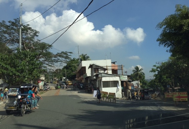 Pinagmisahan Street on the left with ‘No Entry’ signs for the Circumferential Road section being maintained.
 On a typical weekday, there are many school service vehicles parked along the road. Many of these are for the Montessori school across from Clinica Antipolo, which does not have sufficient parking for vehicles it attracts.
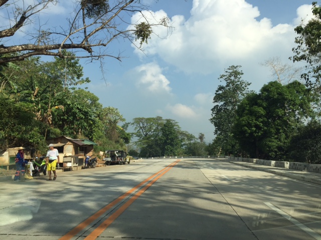
 Pinagmisahan used to be a narrow 2-lane road. It has been expanded recently into a 4-lane road with Portland Cement Concrete Pavement (PCCP).
 While the expansion included the construction of sidewalks, many electric posts remain in their original positions and pose safety hazards to motorists.
 White Cross, which is a popular destination during the Lenten Season and especially during the Holy Week is accessible via this road.
 There appears to be many informal settlers living in communities along the road. They have encroached on the RROW and hamper the completion of the expansion of the road.
 I think this part of the road is practically the highest in terms of elevation. There should be a good view of the surrounding areas including the city center and Hinulugang Taktak from this area.
 Another section of Pinagmisahan showing informal settlers
 Curved downward section towards Daang Bakal and Taktak Road – the fence on the left is for Fairmont Subdivision.
 Straight section approaching Daang Bakal
 Approach to intersection with Daang Bakal – the other lanes of the road is used as parking for visitors of Hinulugang Taktak
 Daang Bakal with Hinulugang Taktak on the left
I’m featuring Pinagmisahan here as I thought its timely given a lot of people will be using it this Holy Week to go to White Cross, which has life-size images for the Stations of the Cross.
–
On logistics in the Philippines
I am not a logistics expert and will not pretend to be one. I have, however, been involved in several projects that included logistics as a major study component. These include a nationwide study on inter-regional passenger and freight flow and another for freight forwarders affected by vehicle restraint policies in Metro Manila. A more recent engagement has allowed me to take a look at logistics in the country from other perspectives including that of national agencies seeking to improve goods movement in the country and development agencies that have committed to help the country to do just that. There are local issues and there are regional ones. The regional ones often involve the need for infrastructure such as maritime ports and airports, highways and bridges, and other facilities such as those for storage and refrigeration.
For an archipelago like the Philippines, logistics is a bit more challenging than in countries whose territories are not separated by bodies of water. There is no lack for good practices though as there are other archipelagos that could provide good examples for connecting the islands such as Japan and the United Kingdom. Nearby, we share similar challenges with Indonesia and to a certain extent Malaysia. Of course, availability of resources is always an issue and particularly for the prioritization of infrastructure to be constructed aside from those that need to be maintained. The DOTC along with its attached agencies like the Philippine Ports Authority (PPA) and the Civil Aviation Authority of the Philippines (CAAP) are in the frontline when it comes to airports and ports planning, development, and maintenance are concerned. However, the DPWH plays a vital role for highways and bridges and the connections for these ports and airports including what is termed as “last-mile” connectivity that is often passed on as a responsibility of local governments. This is likely due to local roads often providing the connection between national roads (under the DPWH) and ports and airports. It is a good thing that the current DPWH has committed to a convergence program regarding national and local roads that has benefited a lot of sectors and industries like tourism and agriculture.
Rail transport is not mentioned here because there is practically none even for what remains of the once relatively extensive PNR main lines. The local issues are not simpler and can be a bit more complicated than the regional ones. The complications are usually due to more petty circumstances that may involve politics and local power plays. The basic ingredients though are related to traffic congestion and the damage to roads and bridges attributed to trucks.
Many cities and municipalities have implemented truck bans along their major roads. These are usually one or two routes in the smaller cities and towns, usually passing through the “bayan,” “poblacion” or central business district (CBD). These roads are usually national roads (e.g., McArthur Highway and the Pan Philippine Highway pass through many towns). As such, there are cases where bypass roads are constructed to alleviate congestion along these roads as well as to try to preserve the pavements in the town proper. Such traffic schemes targeting heavy vehicles are not new and are also a way to address the issue on overloading that is common in trucking in the Philippines. The bypass roads, however, generally invite development and unplanned development have often made these alternate routes more congested than the original ones.
Manila did a “power play” recently by implementing a more aggressive truck ban. This led to more severe congestion around the Port of Manila and a lot of delays that have cost a lot of money in part due to the limited alternative routes in the city and most roads are already constricted. The costs have repercussions on the economy in general as the movement of goods are affected by the impasse in Manila. Whether this was for more political or practical reasons is difficult to say because the mayor and vice mayor have invoked the very common issues of traffic congestion, road safety and pavement maintenance that got the attention, sentiment and agreement of a lot of people. Many of these people though do not understand the impacts of inefficient goods movement and likely are concerned only about passenger transportation.
More recently, a lot of containers were shipped from the Port of Manila to Subic. These are supposedly “overstaying” shipments or those that have not been claimed for a long time or have some issues regarding their release. This should ease congestion somehow but there remain the problems of shipping or logistics companies regarding freight transport in general that needs to be addressed. Both Subic and Batangas ports have been mentioned in many formal studies over the past few years including a more recent one supported by JICA. Still, there is a lot of hesitation if not confusion or uncertainty on how to go about with shifting goods movement to these ports, which are regarded to be underutilized. There are good roads connecting these ports with cities and towns but these might not be enough in the long run.
Perhaps there is a need to reconsider regional rail transport again especially for the islands of Luzon and Mindanao where long distance rail may have a tremendous impact for transporting goods over long distances. Of course, there are also issues pertaining to other ports and airports in the country including those in Mindanao (e.g., Davao, Cagayan de Oro, Phividec, Gen. Santos, etc.) and Visayas (e.g., Cebu, Iloilo, Tacloban, etc.). The RORO ports are among those that need attention as they are directly involve road transport aside from the ferries that carry them over the waters. These nautical highways are vital for goods movement around the country and require both national agencies and local governments cooperating for these facilities and services to function efficiently.
–
Some good reads on rural roads
A couple of articles came out recently on Rappler that focuses on rural roads:
Farm to market roads: a farmer’s journey, March 5, 2014
The future of rural roads, March 8, 2014
Both are solid articles and places our attention to rural roads and particularly farm to market roads (FMRs). There’s a wealth of information in the articles as well as the links embedded that allow us to see past and present efforts on rural roads. It is good that government with the help of international agencies are investing resources on these roads and we hope that this will be sustained in order to effect what has been touted as inclusive growth.
 Rural road connecting to a national highway in Palawan
Rural roads are an important and integral part of of our transportation system. Often, attention is placed on national roads, which are under the jurisdiction of the DPWH. Local roads, however, are under various entities including the Department of Agriculture and various levels of local government (e.g., provincial, city, municipal). Of course, there are roads that are rural but are national and therefore under the DPWH. But most roads are classified as local and therefore would not be directly under that national agency. In fact, 85% of our roads are considered local and those classified as rural comprise perhaps more than 70% of the total roads in the country (i.e., national roads can be urban or rural, and city roads include those in the rural parts of cities). Rural roads including FMRs are essential as they provide basic access to jobs, education, health services, markets and other services that could help alleviate poverty and promote development in rural areas.
–
