
Home » Posts tagged 'Marikina'
Tag Archives: Marikina
After getting engrossed with EDSA, is Marcos Highway next?
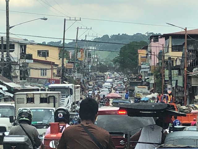
If you monitored the news articles and social media post over the past two decades, there seems to be an obsession for EDSA. Circumferential Road 4 is the busiest corridor in Metro Manila, stretching across several jurisdictions including Caloocan, Quezon City, Mandaluyong, Makati and Pasay City. Aside from the MMDA, national agencies like the DPWH and DOTr have been heavily involved in traffic schemes and transportation infrastructure development along the corridor. These include variants of the travel demand management (TDM) scheme commonly called number coding. Since the 1990s, there’s the Line 3 and several overpasses/flyovers and underpass that have been constructed along major intersections (e.g., EDSA-Shaw, EDSA-Ortigas, EDSA-Kamuning, EDSA-Quezon Avenue, etc.). Nowadays, people are more into the EDSA carousel and most recently the pavement rehabilitation for EDSA. It seems we failed to realize that EDSA is just one corridor. There are others that also demand attention including those in other parts of the country.
Recently, a “carmaggedon” along Marcos Highway was in the headlines or shall I say was trending in social media. There was a lot of excitement for what has been a recurring nightmare to those residing along the corridor. I recall something worse occurred more than 15 years ago (pre-Ondoy), before social media and influencers and digital creators. At the time, Line 2 terminated at Santolan Station. And even back then, the MMDA insisted on playing with their U-turn scheme. I don’t recall a more in-depth study that could have involved micro-simulation modeling being done for the corridor. And since then, populations and traffic have grown steadily and as I’ve written about previously, the extension of Line 2 to Masinag seems to have had little impact on traffic. And so here we are with the MMDA still insisting on tweaking their U-turn schemes and relying mainly on gut-feel instead of a more scientific approach that may actually lead to more sound solutions for the corridor.
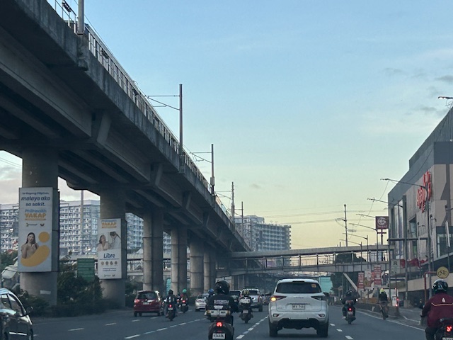
 Approach to Marcos Highway from Felix Avenue – that’s the elevated Line 2 superstructure behind the Cainta arch.
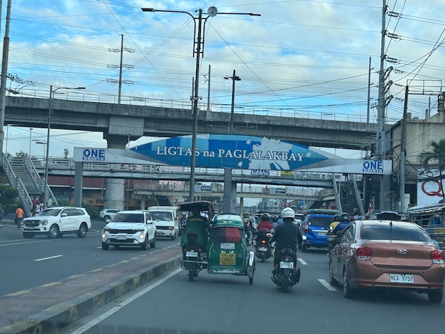
 Intersection of Marcos Highway, Felix Avenue and Gil Fernando Avenue – there’s a major foot bridge installed here so people can cross at the intersection, which used to be a signalized junction before the MMDA opted for U-turns for Marcos Highway sections under its jurisdiction.
 Marcos Highway section fronting the Ayala Feliz Mall – the MMDA has played with the location of the U-turn slots in the vicinity of the Marcos Highway-Amang Rodriguez-J.P. Rizal intersection as they tried to determine the “optimum” locations of these slots.
Of course, there is also the case of Commonwealth Avenue. How many carmaggedons have occurred along that corridor? Isn’t it an everyday thing there? And there’s also Ortigas Avenue Extension and many other roads and streets where congestion seems to have been accepted as the norm. How do we make travel easier for most people? How do we improve commutes given the constraints and realities concerning behavior and choices?
–
Vehicle refuge during floods
Passing Felix Avenue one early morning this week, I saw familiar scene. There were lots of vehicles parked along Felix Avenue (formerly Imelda Avenue) including the service roads along either side of this major road connecting Marcos Highway and Ortigas Avenue Extension.
These vehicles are owned by residents of subdivisions along the avenue whose areas are prone to flooding. These include Vista Verde, Metroville, Kasibulan, Karangalan and the two Green Parks. I didn’t see this along the stretch so the other flood prone villages like Village East and Country Homes. Perhaps they have been able to adapt better?
Car-centric discussions aside, when you go the ‘east’ you will notice a lot of people using SUVs. One reason probably is because many Rizal towns including Antipolo City, and Pasig and Marikina Cities are prone to flooding. Can you imagine over 50 years of flooding in these areas? And then with the current investigations concerning flood control projects, have you wondered if the ‘east’ really got their taxpayers’ money’s worth in terms of interventions?
–
Post-typhoon BFCT and SM Marikina area
Still on the aftermath of Typhoon Ulysses (Vamco) though this is already a late post about it, here are some photos at the river banks level on the side of SM Marikina and the vicinity of the transport terminal constructed and operated by the former MMDA Chair and Marikina Mayor’s company. The area is basically a flood plain and in other countries would not have been suitable for building. Rather, these are often used as open spaces like parks, football fields or baseball diamonds, among other possible uses.
 There were garbage and mud everywhere. By the time I passed by, the mud had dried up and turned into fine dust that blanketed the area.
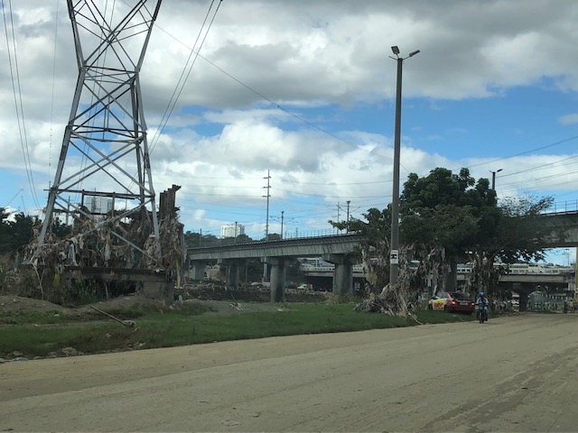 Trash were everywhere and you can see how deep the water was by the garbage still on the power line towers and the trees.
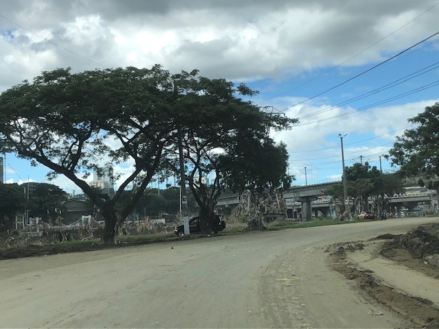
 Underpass leading to SM Marikina – bulldozers and payloaders were busy moving mud and garbage to clear the roads. There were no signs of the work in progress so I ended up making a U-turn seeing the way to SM’s parking was blocked by mud and debris.
 On the way back to Marcos Highway, you can see the large trees that were transferred to this area from Katipunan Avenue (when it was widened by way of removing the service road to give way to the MMDA’s U-turn scheme). It is heartening to know these survived the river’s onslaught.
–
The FVR Road and Bridge after Typhoon Ulysses
This is a continuation of the feature on the aftermath of Typhoon Ulysses (Vamco). I am posting this here as part of my archives on the floods in the Marikina Valley.
There’s a road branching off from Marcos Highway that links to a bridge crossing the Marikina River and connects with the FVR Road along the Marikina Riverbanks. The following photos speak for themselves in as far as the mud and garbage that was left after the floods subsided.
 Descending from Marcos Highway, only one of two lanes are passable after heavy equipment moved tons of mud and garbage to the roadsides. The fences trapped a lot of garbage, too, as seen in the photo.
 Piles of mud and garbage at the service road leading to the east bank of the Marikina River and the SM Marikina access road.
 Under the Marcos Highway Bridge, garbage, mostly plastics, remain on the wire fences. This area was totally submerged during the height of the floods with water reaching the underside of the bridge. Fortunately, the bridge seems undamaged.
 Even lamp posts and electric poles caught a lot of garbage.
 The Olandes housing development was surely affected by the swelling of the river.
 The FVR Road leading to C-5 is already clear for 2-lane traffic but you can see the mud and garbage all around. The dried mud has turned into dust (alikabok) that blows away as vehicles pass through the road. There is also mud on the plants in the median planters as this area was also submerged during the height of the typhoon.
–
Tumana during and after the flood
I was heading to the office the Monday after Typhoon Ulysses had devastated wide areas in Luzon. I was aware of the congestion along my usual routes so I used Waze to guide my trip. Waze took me to Tumana instead of Marcos Highway, which I assumed would have been less congested. I took the following photos in the Tumana area:
 Congested main road due to heavy equipment like bulldozers, backhoes and dump trucks clearing the mud and trash in the area. There were also lots of parked vehicles along each side of the road including Marikina service and emergency vehicles.
 There was trash all around that included what looked like the belongings of people residing in the area. Many people were busy clearing their homes of items destroyed or damaged by the floodwaters.
 Despite being cleared for traffic, you can see the mud and water still in the area and signs of how deep the flood waters were by markings on the buildings.
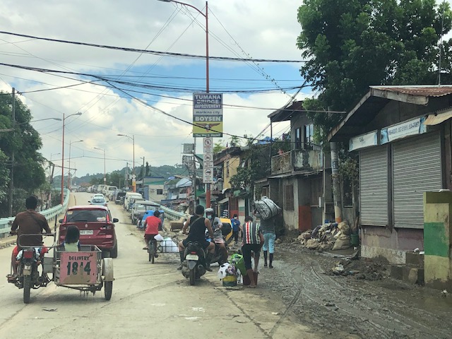 At the foot of the bridge connecting to Quezon City, you can see that there is still so much mud in many areas especially those closest to the river. Sidestreets were so narrow that the heavy equipment cannot enter them and cleaning the mud had to be done entirely manually.
 Here are what looks like the vehicles that survived the floods. I thought people must have rushed to get their vehicles on the best positions atop the bridge when they realized the waters were rising fast. It was likely few if anyone left their vehicles there during the height of the typhoon. That’s because the winds were so strong that perhaps people though it would be unsafe to leave their vehicles exposed to the winds.
The following photos from Facebook shows the extent of the flooding that reached the other side of the river – Loyola Grand Villas and another subdivision that’s directly along the banks of the Marikina River. The first photo shows the submerged end of the bridge from the LGV side in the foreground and Tumana in the background at the other end of the Tumana Bridge. The second photo is atop LGV and shows many submerged homes and cars.
 Only the cars on the bridge likely survived the floods.
 This was definitely at the level of the floods of Typhoon Andy (Ketsana) given the spread and depth of the floods.
One wonders what is now the return period for these typhoons. Ondoy was 11 years ago and the monsoon (Habagat) rains that also brought heavy rains and floods were in 2012 (8 years ago). Such floods cannot be solved by improving drainage systems alone but have to go to the root cause of flooding while also addressing how people could cope with these phenomena. Infrastructure alone cannot solve this and certainly will cost a lot for any initiative to provide some relief from such.
–
Evidences of demand for Line 2 beyond Masinag (again)
My commute between my home and office usually takes me to Masinag where I make the choice between traveling via the typical Marcos Highway route or via the alternative Marikina/Tumana route. Here is a scene that I usually see whenever I pass by the informal UV Express terminal just past the Masinag junction along the westbound side of Marcos Highway and just before the Decathlon sports facility currently under construction.
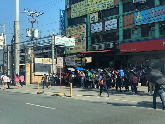 Passengers waiting for UV Express vans or AUVs to return around 8 AM. The latter serve the Cogeo – Makati (Greenbelt) route, which could take 2 or 3 rides using other modes of public transport (e.g., one ride to Cubao and another from Cubao to Makati)
Note how many people cannot get a ride around 8 AM. If only there were more efficient options then these people would likely take them but for now the obvious and practical choice for them is the UV Express. Others, of course, can just walk further to SM Masinag where there is a P2P bus service also heading to Makati. Recently, a new “experimental” route was opened between Cogeo and SM Aura in Taguig using modern jitneys.
Once completed, Line 2 should be able to provide an alternative for these commuters but there is still the issue of a seamless transfer in Cubao. There is no direct connection between the Line 2 and Line 3 stations with the former connected to the Gateway Mall while the latter is connected to Farmers. That is a significant walk between the two stations.
But where do the commuters in the photo come from (origin?)? Most likely don’t reside around Masinag Junction though there are many residential area around this location. Many are ferried here by tricycles, jeepneys or private vehicles. Many likely have their own cars but opt not to drive to/from Makati. That is actually a good thing and something that needs to be sustained rather than give a reason for these people to use cars for their commutes. And so there is a need to extend Line 2 perhaps to Cogeo, and a branch to Marikina. The Marikina branch, as I’ve mentioned before, could terminate at the Marikina Sports Center. Meanwhile the extension to Cogeo should not stop there but continue further towards Antipolo’s new government centre. This corridor’s population is steadily increasing and the transport demand must be addressed not by low capacity modes but by a mass transit system. The low to medium capacity modes should be in support or at most supplementary to the high capacity system with the Line 2 as backbone.
–
Traffic management schemes for the Marcos Highway bridge rehab
The rehabilitation of the Marcos Highway Bridge in Marikina has necessitated traffic management schemes at the bridge itself and along alternative routes to alleviate congestion in the area. These are collectively called traffic or transport systems management (TSM) schemes with the objective of optimising existing infrastructure and resources without necessarily building something entirely new. These are quite different from travel demand management (TDM) schemes that include number coding and truck ban policies that are already being implemented (though Marikina does not implement the number coding scheme).
 Traffic build-up at the approach to the intersection with FVR Road (To Riverbanks). This is now a signalised intersection as traffic from Blue Ridge/White Plains is now allowed to cross to FVR Road.
 Using the route via FVR Road (Riverbanks) means you don’t have to cross the Marcos Highway Bridge and travellers will merge with those who crossed the bridge just before the Line 2 Santolan Station.
 In the mornings, one lane each is allocated for either the eastbound or westbound traffic. That’s practically a total of 3 lanes (+2 lanes westbound for the SM Marikina Bridge) for the westbound direction and a single lane for the eastbound side. This is logical given the directional distribution of traffic at this time of day and the alternative routes already available to travellers.
Here are a few photos taken on a night time drive. Note that this was taken by a passenger. Don’t even try doing this (taking photos) while driving a vehicle, and especially not while on a motorcycle.
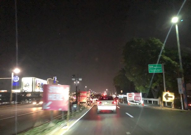 Entrance to the bridge right after Maj. Dizon – this part is not affected by the rehab works but vehicles position themselves to shift towards the left side, which is the usable part of the bridge.
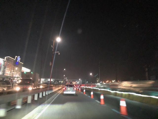 Both lanes of the westbound side of the bridge are used for eastbound traffic. Westbound traffic are all along the SM Marikina bridge for a total of 2 lanes each for either direction of flow. The cones are not removed for practicality since they would have to be installed for the morning when one lane is allocated for the westbound traffic.
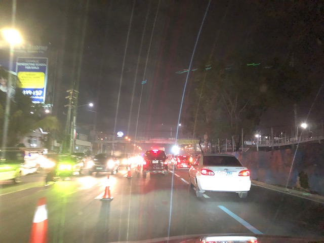 Vehicles shift to the right to return to the correct lanes for eastbound traffic along Marcos Highway at the Santolan area. Note the westbound vehicles shifting towards the underpass and SM Marikina on the left.
–
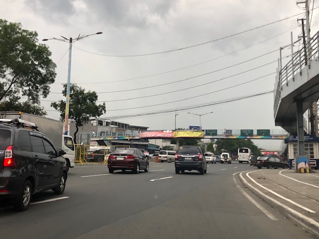
On the impacts of the closure of the Marcos Highway Bridge
The Marcos Highway Bridge was scheduled for rehabilitation in the next four months starting last week. While it will not be totally closed to traffic, the scheme reducing its capacity will surely lead to congestion along Marcos Highway. This congestion should be expected along other roads as well, as travellers, particularly those taking private transport will be using alternative routes in order to avoid this area. Those coming from the east will likely go through Marikina City via the parallel route comprised of Sumulong Highway and A. Bonifacio Avenue. Others will turn to A. Rodriguez (Ligaya). And perhaps others may go via Ortigas Avenue Extension. These alternative routes correspond to the other bridges crossing the Marikina River connecting the Rizal province and part of Marikina and Pasig to Metro Manila.
 A photo of the bridge prior to its partial closure
I will write more on this topic once I get more information on what’s happening to the traffic in the area. Meanwhile, I do know that my usual alternative route via Marikina and Tumana seems to have more than the usual traffic during my commute. While it is easy to attribute this to the partial closure of the Marcos Highway bridge, this could also be just a normal variation in the typical daily traffic for that route.
–
Marikina’s Bike and Parking Lanes
I had to navigate through Marikina’s streets in order to reach the Feliz Mall from the city’s downtown. Normally, I would have taken the more straightforward route that would have involved traveling along Marcos Highway. However, I couldn’t because it was my number coding day and the U-turn slots in the area are usually “swarming” with MMDA and Pasig City traffic enforcers. Marikina’s streets though were not part of the coding scheme and you only need to be familiar with their road network including which streets are one-way in order to navigate the streets properly.
 The bike lane is on the left side of the one-way road and to the right of the on-street parking spaces. The parking lane is the left-most and curb-side.
 This actually qualifies as an example of a road diet application. These could have easily been 2-way streets before but effectively 2 lanes have been allocated for traffic flow while the others are for parking and cycling. [Of course, hard-core cyclist will say only one lane was taken away from motor vehicles.]
These bike and parking lanes were implemented in connection with the Marikina Bikeways project that was initiated during the time of then Marikina Mayor Bayani Fernando in the late 1990s. The project was continued and maintained by succeeding administrations of the city and contribute to the city’s being more liveable compared to other LGUs. The reconfiguration of the streets make them safer and saner in terms of traffic flow where “traffic” is referred to as inclusive of all users.
–
On fact-checking articles in this blog site
Last month, I received an interesting and intriguing comment that was actually an inquiry about an article I posted that contained a photo of a section of the Marikina Bikeways. A news agency was fact-checking something circulated by trolls praising Davao City for putting up bikeways. The problem is that they used my article and photo taken some years ago:
https://d0ctrine.com/2014/09/30/lets-revisit-the-marikina-bikeways/

The photo was taken by me one time I was driving along Sumulong Highway in Marikina City’s downtown area. I take similar snapshots whenever the opportunity presented itself and I thought this one was perfect because it showed bicycle infrastructure and a cyclist using it. I don’t put any watermarks or other identifiers on my photos but routinely advise those using or intending to use them to do the proper attribution or citation.
Credit is due to the people of Marikina and their leaders for making their bikeway network a reality. Of course, there are issues here and there but the important thing was that they were able to construct it and show that it can be done given the resources in support of active transportation modes. I am not sure if Davao has initiated a program to plan and construct a bikeway network for their city. Perhaps there is and perhaps there’s none. But perhaps, too, they should take the cue from Marikina and develop one that can also be emulated or replicated in other LGUs as well. It is better to come up with something real and tangible rather than being credit for something inexistent.
–
