
Home » Posts tagged 'traffic engineering'
Tag Archives: traffic engineering
Article share – My provocative proposal: Want a roadway safety movement? Ditch the engineers.
Here’s a quick share of an article on who should be involved in road safety:
Source: My provocative proposal: Want a roadway safety movement? Ditch the engineers.
On roundabouts and how they can improve safety at intersections
Roundabouts are perhaps something that should be considered for Philippine roads. The concern, however, is that Philippine drivers don’t know how to navigate or position themselves in roundabouts. And the results as we have seen in several cases are congested roundabouts or rotundas.
AASHTO (September 26, 2025) “State DOTs Highlight How Roundabouts Improve Safety,” AASHTO Journal, https://aashtojournal.transportation.org/state-dots-highlight-how-roundabouts-improve-safety/%5BLast accessed: 10/19/2025]
To quote from the article:
“To highlight the safety benefits of roundabouts, the Ohio Department of Transportation recently released an analysis of crash data from 76 intersections statewide that had been converted to roundabouts. That analysis indicated single lane roundabouts decreased injury crashes by 69 percent while multi-lane roundabouts resulted in a 25 percent decline.”
And here another quotable from the same article:
“For us, it’s simple. Roundabouts remove cross-traffic turns and eliminate T-bone crashes, while improving traffic flow,” said PennDOT Secretary Mike Carroll …”“Any design that dramatically reduces the most serious crashes we see on the road is worthy of consideration in our projects.”
The article also includes a YouTube video on traffic circles.
–
Article share: In Defence of Vision Zero — a Traffic Engineer’s Perspective
On weekends, I try to catch up on reading articles that I have deferred indulging on during busy weekdays. One such article that I have repeatedly put off reading is this one on road safety:
Source: In Defence of Vision Zero — a Traffic Engineer’s Perspective
To quote from the article:
“For years, success in transportation was measured in level of service, vehicle throughput, and reduced delay times. But Vision Zero forced the industry to confront a difficult truth. The more we prioritized speed and volume, the more we endangered the most vulnerable users of the road: pedestrians and cyclists, with particular emphasis on children and older adults. Those who sit in decision-making positions must recognize the realities of physics, namely that the human body is frail and vulnerable to a transportation system that prioritizes throughput over safety.”
The article is a really good read and one that I would recommend for my students in Traffic Engineering to read.
–
Complex intersections in Davao City
My first project upon my return from Japan in 1999 was the Davao City Transportation and Traffic Management Plan Study. We found a few interesting intersections there. These included junctions with more than 4 legs. If all or most movements were allowed at these intersections, they would be most complicated and risky due to the number of conflicts. Of course, not all movements are allowed and many legs are one-way meaning there are fewer conflicts and less risky.
 These intersections are large and while there are traffic signals, they were off when I was there.
 Surprisingly, there was no congestion or near crashes. Either, traffic was light at the time (before 7AM) or motorists were driving at a level similar to Vietnam (where vehicles were like ants as they moved at intersections).
A bit of trivia here – 1999 to 2002 was the only period in a long time when a Duterte was not mayor of the city. This was the time the former president relinquished the mayoralty in favor of his Vice Mayor and was instead congressman representing the city. He immediately returned after one term rather than serve out 3 terms.
–
On the need to rethink traffic metrics
While Level of Service (LOS) criteria is a concept that can be applied to many other transportation facilities and aspects, among the LOS criteria that have been the subject of much criticism (and perhaps rightfully so especially in the context of safety) are the ones used for intersections. These are associated with delay reduction, which always favors vehicular throughput. The latter means basically, high LOS corresponds to prioritizing car (or motor vehicle) movement while not particularly taking into consideration the safety and movement needs of other road users (not using motor vehicles). Here is an interesting article on this matter:
Boenau, A. (July 9, 2025) “The old traffic math that keeps destroying neighborhoods,” Fast Company, https://www.fastcompany.com/91362348/road-design-traffic-math-destroying-neighborhoods-los [Last accessed: 7/15/2025]
Quoting from the article:
Here are three important questions for experts to ponder:
- Is slow-moving car traffic ever safer than fast-moving traffic?
- Do we have any obligation to provide safe and convenient access for people when they aren’t inside cars?
- What are the economic downsides of wider, faster streets in the central business district?
When planners and engineers truly wrestle with those questions, they can choose to remain a conformist who ignores the damage of traffic metrics, or become an outlier in the industry and make a positive impact that might be felt for generations to come. Things can get better in the end.
–
Again, I must say that rethinking roads and streets should be context sensitive. Still, safety should be the top concern especially for areas that is predominantly residential and/or school. Safety, after all, comes first in the definitions of transportation and traffic engineering.
–
Technical sessions at the TSSP 2024 Conference
I am sharing here the latest draft of the technical sessions for the 30th Annual Conference of the Transportation Science Society of the Philippines (TSSP). The conference will be held in Iloilo City this coming September 13, 2024.
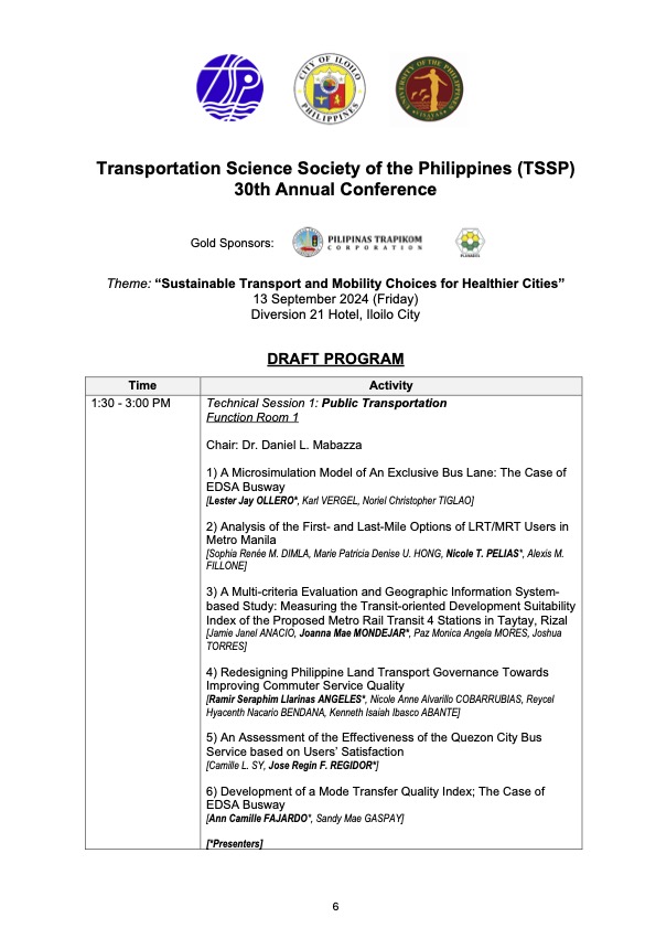
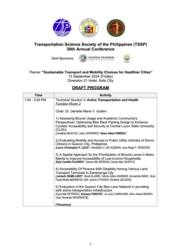
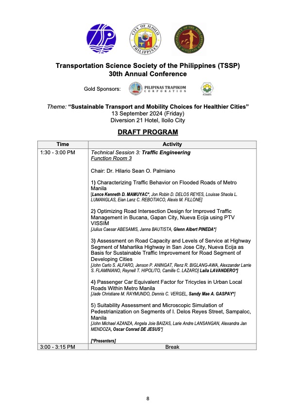
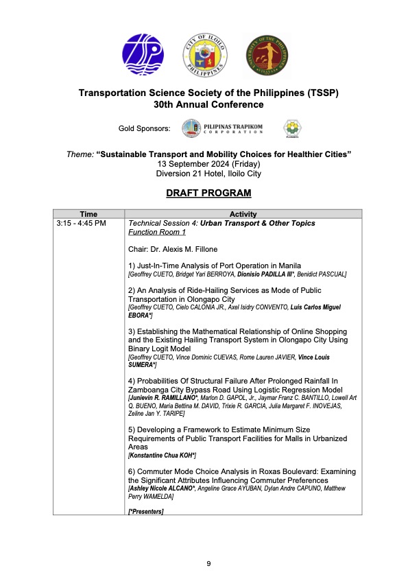
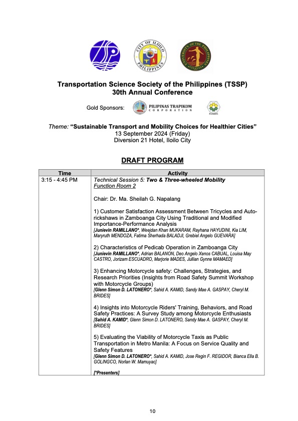
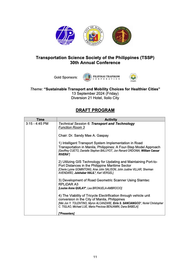
I will share the draft program for the morning plenary session in the next post.
–
Still on the Katipunan zipper lane
I’ve occasionally arrived at Katipunan with the experimental zipper lane still in use. I usually take Major Dizon from Marcos Highway in order to have a chance of using the zipper lane. That is, I take the left-most lane of C5 so I am in a good position in case the lane was available when I get to the Ateneo area. Perhaps it is already assumed that the right most lanes are already dedicated to vehicles bound for Ateneo or Miriam (mostly Ateneo I suppose).
So far, I’ve been able to use the zipper lane only once. On the other times, I stay on the left-most lane (beside the island) of Katipunan/C5. The zipper is relatively short as vehicles return to the correct side of the road at Ateneo Gate 3. The merging there means slower movement of both the zipper lane and the median lane traffic. So is the zipper lane a success? I would say the experiment is just above “marginal success” (or pasang awa) given its limited application. It doesn’t hurt to implement the scheme as traffic along the southbound side of Katipunan is generally light anyway.
–
Tikling junction traffic
Easily a pet peeve along my commute is Tikling or Kaytikling Junction in Taytay, Rizal. I think traffic here is worse than two other major junctions in Rizal Province – Cainta Junction and Masinag Junction in Antipolo City. And that is because of the combination of traffic management (or mismanagement) by elements of the Taytay Municipal Government and motorists lack of understanding of how vehicles should position (or travel) at roundabouts. Of course, the volume of motor vehicle traffic converging at this junction would probably merit traffic signals over a roundabout but for most times when there are no enforcers here, traffic is somewhat more efficiently flowing as drivers and riders are forced to give way in order to not constrict traffic.
 Enforcers often employ the “buhos” system of prioritizing traffic for one leg at a time. However, instead of a quick transition from one leg to another, they tend to give more time to vehicles coming out of the Manila East Road and turning left and (west)bound for Ortigas Avenue Extension. The long time allocated to the latter means long queues for traffic coming down from Antipolo and those from Cainta.
 Enforcers are partial to outbound traffic from Taytay rather than make an effort to have more equitable ‘go’ time for all legs at the junction.
One wonders who is in charge of traffic for Taytay considering they mismanage traffic everyday. [Though I also wonder why the rest of Rizal including Antipolo and Cainta can’t seem to be bothered by the congestion emanating from Tikling.] As if to prove the point of incompetence, another problematic intersection is the Highway 2000 – Barkadahan Bridge – East bank road intersection, which is signalized and yet somehow always congested (or saturated). But that’s another story.
–
A zipper lane along Katipunan?
Yesterday, the Metro Manila Development Authority (MMDA) started another experiment along Katipunan Avenue in Quezon City. They introduced a zipper lane along the stretch fronting Ateneo’s Gate 2 and Miriam College’s main gate (about 740m – less than a kilometer). This single lane was supposed to ease traffic congestion along the northbound direction of Katipunan (aka Circumferential Road 5 or C5 or Pres. C.P. Garcia Avenue), which is saturated with vehicles especially during the morning peak.
While we wait for the official pronouncements regarding this experiment, the impacts are likely to be marginal as the original northbound lanes are jammed with vehicles. Thus, there is a tendency for the entry to the zipper lane to be blocked. MMDA staff will also have to stop vehicles at the exit if they will allow the movement of left-turning and U-turning vehicles at the junction with B. Gonzales and Miriam’s main gate. While it may seem an exercise in futility, we have to appreciate the continuing effort of MMDA for such schemes. The bottomline though is the MMDA has limited options to address the hellish traffic along Katipunan. The schools and other establishments would need to put their heads together to formulate a more sustainable solution for this corridor.

On the coordination of traffic signals
I took a couple of photos while we were traveling along Espana Boulevard. I wanted new photos of the traffic signals along Espana to use as visuals for my examples whenever I discuss traffic signals and their coordination or synchronization in my lectures.
 Green signal for traffic. If the traveler is able to travel at the optimum speed, one will be able to catch the green light at so many intersections along Espana. The road is the major thoroughfare in the area and traffic along it is prioritized over those from the side roads to maximize the throughput along Espana.
 If one catches a red light at one intersection, it is possible that the traveler will catch a red light in the next intersection(s).
–
