
Home » Posts tagged 'traffic management' (Page 6)
Tag Archives: traffic management
Traffic congestion in Tagaytay
We got to see first-hand last weekend how terrible the traffic congestion in Tagaytay has become. Last year it was already bad but last weekend’s traffic was really awful. To be fair, not counted in the traffic jams mentioned here are roadworks (i.e., widening) currently being conducted by the DPWH along the Sta. Rosa – Tagaytay Road that have also contributed to the longer travel times to and from Tagaytay. The severe congestion is due to the intense developments in the city including high density residential and commercial developments in a city where transportation, including the road network, is not built to be able to handle the trips generated by such developments.
My brother took the following photos as we drove back to Manila:


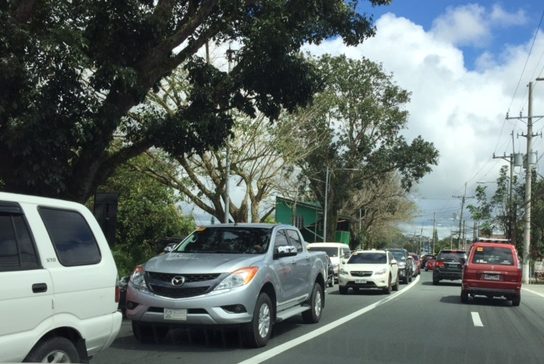


The photos pretty much describe how congested roads are. All two lanes are full with what is basically bumper-to-bumper traffic. The last photo was taken in front of the Estancia Hotel, which is about 1.4 km from the rotonda, and the queue appears to continue well beyond this area (i.e., past Starbucks). This is a result of the traffic management at the Tagaytay rotonda where, instead of allowing vehicles to move freely (which is how rotondas are supposed to function), traffic enforcers instead stop movements from the 3 legs one at a time. The problem here is that the congestion due to the Serin mall often reaches the rotonda, and so vehicles could not proceed to exit on that leg of the intersection. This condition affects traffic from all legs and results in long queues along the Aguinaldo Highway as well as both the rotonda-bound sides of the Tagaytay-Nasugbu Highway. Vehicles cannot make left turns to Serin or the Lourdes Church because of the median barrier set-up along the highway so all have to go around the rotonda. Quite frankly, I see very little or no options in as far as solutions go. The traffic is simply too much for the roads to handle.
–
The Tagaytay transportation predicament
The title of this article is actually a bit tame and on the diplomatic side of trying to describe transportation and traffic in this city that was once relaxed a retreat for many. I had wanted to end February on a good note and so I decided to defer posting this until March.
We used to frequent Tagaytay and liked spending some rest and recreation time there to the tune of being there almost once a month at one time. Needless to say, at the time travel to Tagaytay from our home in Antipolo took us only about 2 to 2.5 hours excluding our usual stop at Paseo in Sta. Rosa, Laguna. We liked the city so much that we even considered making it a second home; even inquiring and looking at properties there.
Fast forward to the present and it has become an excruciating travel with the highways leading to the city already congested. It didn’t help that when you got there, you also had to deal with serious traffic congestion. This started not a few years ago when the city approved developments by major players including Robinsons, SM and Ayala. The developments by SM and Ayala proved to be the backbreakers with Ayala coming up with the first mall in the city and SM operating an amusement park beside its prime acquisition that is the Taal Vista Hotel. Now, there is another mall under construction by Filinvest and right at the corner of the rotonda where the Aguinaldo Highway terminates.
Vehicles queue along the Tagaytay – Nasugbu Highway towards the Rotonda where Tagaytay traffic enforcers attempt to manage traffic but appear to create more congestion instead.
More on Tagaytay soon…
–
Motorcycle lanes along Sumulong Highway?
I noticed something along my commute and that is the newly marked pavement along Sumulong Highway at the section in Barangay Mambugan until Barangay Mayamot at Masinag Junction. I guess this is more likely part of Antipolo City’s initiative in managing motorcycle and tricycle traffic. In a meeting with the City Administrator, Robert Nacianceno, last year, he said that the city was moving towards improving road safety. That included addressing concerns about tricycle and motorcycle operations that has led to crashes and congestion. Motorcycle lanes designated by blue pavement markings are not new and likely was inspired by the MMDA’s initiatives along major roads in Metro Manila.
 Motorcycle running along the designated lane
 The blue markings are present along both sides of Sumulong Highway
The real challenge with these motorcycle lanes would be on the enforcement. That is, how would the city be ‘encouraging’ motorcyclists and tricycle drivers to stick to the outer lanes of the highway. Such would require a tremendous effort for the city as they will definitely have to apprehend erring motorists and also clear the designated lanes of obstructions. Should this program be successful along Sumulong Highway, perhaps they should consider the same for Marcos Highway.
–
Seemingly minor violations that affect traffic and safety
The following photo shows one of the many minor violations that happen everyday along many roads and particularly at intersections. Motorcyclists and drivers frequently occupy spaces that are supposed to be clear of vehicles. The motorcycles and AUV below occupy the pedestrian crossing that is typically space for pedestrians and cyclists crossing the intersection. Both vehicles also are encroaching upon the intersection’s yellow box, which can be risky given that the intersection is signalised and other vehicles are given the right of movement according to the cycle settings of the intersection.

This and others like it are what seems to be minor incidents but in truth have a combining or cumulative effect on traffic streams that contribute to congestion as well as having implications on road safety. Pedestrians and cyclists are forced to go around the vehicles blocking their paths, likely putting them in harm’s way. Other motorists try to avoid these errant vehicles, which, like in the photo, may be blocking the path of vehicles proceeding towards the intersection leg to the right that is hidden in the picture. Motorists doing this must be apprehended by traffic officers/enforcers as these are clear violations of traffic rules. If one is to promote discipline among road users, then it should start with minor violations that tend to be disregarded by traffic enforcers.
–
Addressing congestion due to school traffic congestion
There are two important traffic news stories yesterday:
- MMDA successfully clears parked vehicles outside La Salle Greenhills
- MMDA sets drop off, pick-up points for Ateneo students
For some reason that’s a bit surprising for many, the MMDA seems to have solved two of the most enduring issues on traffic congestion along two major thoroughfares. LSGH is along Ortigas Avenue while Ateneo is along Katipunan Avenue (C-5). Both have high trip generation rates and a significant percentage of their trip gen is comprised of private vehicles. While, Ateneo’s trip generation has led to traffic congestion due to the sheer number of trips the university attracts, the congestion due to La Salle is due to the poor traffic management and lack of parking spaces for vehicles attracted by the school.
I only wonder why it took so much time to address these problems considering the solutions mentioned in the articles are basically ones that could have been implemented years ago. In the case of La Salle, good old fashioned traffic enforcement apparently did the trick. But then, the MMDA even with the LGU constraint could have been stricter before whether when they were under Bayani Fernando (BF) or any of his successors as MMDA Chair. With Ateneo, the scheme is very similar if not the same as what BF proposed over a decade ago when he was MMDA Chair. At that time though a touchy issue was the U-turn scheme he installed along Katipunan that cost trees and the former service road on the west side of the avenue. We can only hope that these claimed ‘successes’ will be sustained and ensure smoother flow of traffic along the major roads they directly affect.
–
Proposals for EDSA and some alternate roads
The hellish traffic congestion along EDSA and other roads in Metro Manila spawned a bunch of ideas for alleviating congestion. Among those that were offered as solutions are the following:
- Odd-Even Scheme – suggested by the Philippines President himself in a speech delivered in Mandaluyong City
- Car-pooling (and HOV lanes) – suggested by the DPWH Secretary in another forum
- Bus Rapid Transit (BRT) and/or express bus – proposed and being studied by the DOTC
What seems to have been forgotten was a proposal to have two lanes of EDSA, one on either direction, devoted to bicycles. This proposal now seems to be the most viable compared to the above three and could have the potential for major behaviour change towards a departure from motor vehicle use. Cycling along with walking does not require fuel and these modes also promote healthy lifestyles. Also, this could become the ultimate example for road diets, which can also be applied along other roads as well. What sounds or reads like an outrageous idea (i.e., bicycle lanes along EDSA) might just be revolutionary and result in what could be a tipping point for sustainable transport in the midst of traffic mayhem.
EDSA has become the proverbial battleground representing the war with traffic congestion. However, EDSA is just one part of our arterial network comprised of circumferential and radial roads. There is also C-5 (also known for its sections – Katipunan, E. Rodriguez, C.P. Garcia), which is also a very congested road but along which there are few fixed route public transport services. It is a primary alternative route (to EDSA)for people traveling between the northern and southern halves of Metro Manila. It also serves as a collector and distributor, being connected with major radial roads like Aurora Boulevard, Ortigas Avenue and Shaw Boulevard as well as to the South Luzon Expressway. C-5 is a major truck route, however, and so carries a lot of heavy vehicles during the permitted times under the truck ban scheme being implemented in Metro Manila. C-5 is already ripe for a mass transit system and should have one along it. The quickest to put up would be a bus system on exclusive lanes. Strategically though, a rail transit line (likely elevated) should already be planned and implemented and with as seamless as possible connections to current and future lines along major corridors.
There are other routes that can be considered which I think have been overlooked (too much focus on EDSA?). C-6, for example, badly needs to be improved and this has started but is being implemented at a slow pace. This could have significant positive impacts on traffic coming from the east (towns of Rizal province) that are bound primarily for Makati and BGC. But then there also has to be a good road bypassing the narrow and already congested streets of Taguig and Pateros that are currently the only roads connecting C-5 and C-6. The roads on the Rizal side (attention: Cainta and Taytay) also need to be improved including Highway 2000 and the Barkadahan Bridge. Perhaps the Rizal Provincial Government should also get involved in this as such routes are in the best interest of Rizalenos. And then there is also the highly urbanized city of Antipolo that is a major destination and already is the 7th most populous city in the country, whose residents also use this route, which is often a faster option to Ortigas and C-5 despite the poor conditions of roads.
–
Capability building for traffic management in Metro Manila
The Metropolitan Manila Development Authority (MMDA) has been on the news lately due to the perceived shortcomings of the agency on traffic management in the metropolis. The current administration has designated the Philippine National Police – Highway Patrol Group (PNP-HPG) to take charge of traffic management/enforcement at six identified choke points along EDSA. EDSA or Circumferential Road 4 has been a battleground of sorts for Metro Manila, representing the capital’s transport and traffic woes with just about all the conceivable problems including severe traffic congestion, high incidence of road crashes and a malfunctioning rail line (MRT Line 3) along the corridor.
The agency was criticized when its head went to Cebu City with a team of enforcement personnel in an apparent effort to augment that city’s traffic personnel. Cebu City has its own traffic management unit in the Cebu City Traffic Operations Management (CITOM), which has been managing traffic in that city for quite some time now. They have been actually ahead of Metro Manila with their own traffic engineering center already integrated with CITOM way back in the late 1980s. The traffic signals around the city were already under CITOM when Metro Manila’s Traffic Engineering Center (TEC) was still under the DPWH. It was only in the last decade that the TEC was formally transferred to MMDA and modernised to the current modern facility beside the MMDA headquarters at EDSA-Orense St. in Makati City. People observed that Cebu was already ahead of Metro Manila on this part and that the MMDA already had their hands full with Metro Manila’s traffic woes. The joke among major cities is that they were learning about traffic management and enforcement from Metro Manila by checking what the MMDA was doing. They will do the opposite. These cities in on the joke include Cebu, Davao and Iloilo, which are all highly urbanized cities looking to alleviate their own transport and traffic problems before these become the level of Metro Manila’s.
The MMDA has the capacity for traffic management as it has the resources including staff to manage traffic around Metro Manila. It even has people to spare that the agency can deploy to assist or supplement traffic personnel in adjacent local governments (e.g., in Rizal, Cavite, Laguna and Bulacan). However, capacity does not mean capability. And MMDA clearly has limited capabilities despite the resources at its disposal. In fact, their traffic management group should be integrated if not closely working with their planning group. Transport engineering, planning and enforcement should go together, working cooperatively in order to come up with comprehensive schemes and solutions that address problems that are progressive in nature.
The old Transport Training Center (TTC) of the University of the Philippines was established to build both capacity and capability for government agencies that included the then Constabulary Highway Patrol Group (CHPG) that was under the then Philippine Constabulary/Integrated National Police (PC/INP) headed by the then Gen. Fidel V. Ramos. The PC/INP became the PNP and the CHPG became the Traffic Management Group (TMG) (later becoming the current HPG) but they all trained under the TTC, which became the National Center for Transportation Studies (NCTS).
The MMDA trained under the NCTS since the 1990s but most of those who did so over the years are now out of the agency and working elsewhere (including those who have migrated to other countries). The remaining training graduates have limited capability and some have quite a bit of overconfidence (this probably is a by-product of the BF era when the agency and its staff were basically taught that they were better than their DPWH and DOTC counterparts and everything they did was right). Mix this with what seems to be confusion about what they need to do and the result is quite amusing.
The MMDA recently established an Institute for Traffic Management (ITM) with the intent of providing training for their own staff and those from local government units. This is apparently with the instigation of their consultants who include a few academics without transport planning and engineering expertise and experience yet dabble in it anyway. I think the ITM is not necessary at this point and it is actually not in the agency’s mandate to provide training programs other than to their own staff. MMDA should focus instead on capability building. If not under NCTS or other local entities they can probably get the knowledge and skills required to manage Metro Manila traffic elsewhere and abroad. In fact, I would recommend that they explore programs offered by the Land Transportation Authority Academy (LTA Academy) of Singapore. These are professional programs that have been developed in cooperation with leading institutions in Singapore like the National University of Singapore (NUS) that can provide a fresh infusion of knowledge to the MMDA. But attendance in such programs is not an assurance that the agency can be better afterwards. The key ingredient would still have to be an effective and progressive leadership that is not under the influence of politics and is committed to no-nonsense traffic management even without the media covering these activities.
–
Causes of congestion along Ortigas Ave. Extension
I have written about the common causes of congestion along Ortigas Avenue. The past articles mentioned the undisciplined loading and unloading along the entire stretch of the road and particularly at either ends of the Manggahan Floodway bridge in Pasig City. I have also written about the congestion caused by private vehicles generated by a private school just a stone’ throw away from DOTC headquarters. This time, I focus on Ortigas Avenue Extension, particularly the stretch from Cainta Junction to Valley Golf.
The current and more critical choke points along Ortigas Ave. Ext. are along the stretch of the road between Cainta Junction and Valley Golf. These are due to the road and drainage works along that section that effectively made the westbound side of Ortigas a single lane road between Brookside and Park Place. There are also road and drainage works along the eastbound side between Brookside and Valley Golf where the entire road section is being elevated. This section is flood prone and has been problematic during the wet season when heavy rains often result in flash floods.
 Counter flow along Ortigas Avenue Extension – this scheme has been the only option for the section between Valley Golf and Park Place Subdivision as the work proceeds one lane at a time. At the time, I took this photo, the counter flow lanes allowed for 2 lanes each for both the eastbound and westbound directions of this corridor. The past week, however, I noticed that during the afternoons and evenings, I noticed that two lanes were allocated for westbound traffic while only one was for the eastbound direction. This should not be the case as the peak direction in the afternoon to the evening is eastbound when people are home bound mainly from work and school.
 The section across from STI is another choke point as the area is one of the ends of the project raising the elevation of the avenue as well as improving the drainage along the road. The traffic along this area has improved much though vehicles still have to slow down to transition between the old pavement and new pavement sections, as well as vehicles turning towards Hunters ROTC Road.
 Unfinished sections – at the time this photo was taken, work along the site was intermittent. Commuters making the observation are often frustrated and much disappointed when they see none working along the construction site. The Mayor of Cainta did very well by talking to the contractor and apparently discussing with the latter how to improve traffic conditions as well as how to expedite the implementation of the project. My own observation was that conditions did indeed improve after that meeting (which was related by the Mayor in his Facebook page) and people could see workers busy with the project even at night time.
Traffic will continue to be bad along Ortigas Avenue Extension until this project is completed. While there should be some significant improvement in traffic flow after completion, congestion will again steadily worsen for this corridor whose private vehicle traffic continues to grow. Public transport is provided by buses, jeepneys and UV Express (whose numbers have ballooned during the last 5 years) and these have contributed a lot to congestion because of their drivers’ behavior particularly when they stop for passengers at areas like Valley Golf, Brookside, Cainta Junction, Ever, Countryside, Manggahan and Rosario.
There is hope though as news proclaim that the NEDA Board has approved the LRT 4 project along this corridor. A mass transit system is indeed necessary and this was required perhaps over a decade ago already. I do hope that this ‘LRT’ is more like the current Line 2 trains and stations than the Line 3 kind. Line 2 is a heavy rail system while Line 3 is light rail. The Ortigas corridor requires a heavy rail system considering the passenger demand in the areas that will be served by the transit system. I also hope that Line 4 is implemented like Line 2 with the government taking responsibility for constructing the system. I have maintained my view that the current administration is too fixated with Public Private Partnerships (PPP) that it had practically given up its responsibility to the general public to provide an efficient and equitable means of public transport for commuting. I just now wonder what became of the proposed BRT line along this same corridor. Perhaps the BRT option has already been abandoned by the DOTC in favor of rail?
–
The return of traffic signals at Katipunan
It’s been more than a decade since the MMDA implemented what was formally called the Grand Rotunda Scheme. To most, it will always be the U-turn scheme that was implemented all around Metro Manila. After seeing what seemed like success along roads like Commonwealth and Quezon Avenue, it was concluded that the U-turns were the answer to Metro Manila’s traffic woes or at least the part that’s blamed on signalized intersections. The perception by many at the time was that traffic signals were not working and caused so much congestion as evidenced by the long queues at intersections. This is not entirely false as intersections with in-optimal settings would definitely bring about congestion especially along corridors or networks where signals are not coordinated. It was, however, a generalization at a large scale and led to more experiments of opening and closing slots in order to determine which would be the most effective combinations. These experiments and their outcomes include drivers becoming more aggressive in order to maneuver ahead of others at the U-turn slots. Weaving has become the norm and in many cases have increased the risk of road crashes.
 Traffic signals have been installed and the section of the median island has been removed across Ateneo’s Gate 3. This will become a three-leg intersections once again but I hope the signals will not favor Ateneo over through traffic along C5.
 Traffic lights are already installed along the southbound side of Katipunan at the approach to the junction with Miriam College’s Main Gate. This will be a four-leg intersection as across Miriam is B. Gonzales Street that connects to Esteban Abada.
The signals are supposed to be operational starting September 13, which is a Saturday. Perhaps this is to try it out first during that weekend and for the MMDA to do some tweaks before the real deal that is traffic on Monday. But then how can you simulate traffic generated by the two schools in the area except maybe if there is significant enough traffic on Saturday? Did the MMDA or its consultants do some simulation using their computers and the VISSIM software they acquired many years ago? Or will we see more of the experiments as signals are fine-tuned according to the conditions along Katipunan?
We are hopeful that the signals along Katipunan will help improve the traffic along this very busy corridor. The results for sections of C5 from Libis (QC) to Ugong (Pasig) are promising and many people I know have told me that traffic has improved. Of course, this may also be partly due to the one-lane policy the MMDA has implemented for trucks. It’s never just one scheme or measure that will work wonders for Metro Manila traffic. It will always be a combination that will alleviate traffic woes in the metropolis. We’ll soon know what will become of traffic along Katipunan. We should, however, temper expectations at least for the 6:30 – 7:30 AM period during weekdays when traffic peaks in the vicinity of Ateneo and Miriam. The sheer volume of vehicles generated by the schools will overwhelm any system that is put up in the area. Nevertheless, for the rest of the day at least traffic flow should improve when signals are operational once again for Katipunan.
–
What’s causing traffic congestion along Katipunan?
An article came out today on a popular online news site stating that the Metropolitan Manila Development Authority (MMDA) blames the Land Transportation Franchising and Regulatory Board (LTFRB) for the severe traffic congestion that is experienced daily along Katipunan Avenue (part of Circumferential Road 5). The article may be found in the following link:
MMDA: LTFRB to blame for Katipunan traffic
Reading the article, I would like to think that the MMDA likely misunderstood the advisory from the LTFRB extending the “non-apprehension policy” for trucks that have not renewed their franchises. This policy is not the same as the truck ban scheme being implemented in Metro Manila by the MMDA and LGUs. The trucks using Katipunan Avenue during the prescribed period that they are allowed travel along this and other roads are not violating any laws or regulations. Meanwhile, the increase in the volume of trucks can only be attributed to an increasing demand for goods that translate into freight movement. There are very limited alternatives to Katipunan Ave., which is a truck route (note: most of EDSA is not a truck route), and there are few wide roads that can accommodate the volume of trucks carried by C5.
I use Katipunan everyday as it is the main road between my home and my office. I can say that traffic has worsened along this stretch of C5 and one can always see the long queue of vehicles caught in traffic along the northbound side of Katipunan especially from the afternoon to night periods. There are many causes of traffic congestion along Katipunan Ave. and during times when trucks are banned from traveling, it is still congested due to the sheer number of private vehicles using the road. C5, after all, is a major road connecting Quezon City with Pasig, Makati and Taguig, which host major CBDs (Ortigas, Makati and Bonifacio Global City).
In the mornings, much private vehicle traffic is generated by the exclusive schools along Katipunan and the northbound side of the road is usually congested from C.P. Garcia all the way to Blue Ridge. Meanwhile the southbound side is full of vehicles from B. Gonzales (across Miriam College’s main gate) to Tandang Sora. In the afternoons and evenings, traffic congestion is caused mainly by traffic returning from Ortigas, Makati, BGC, etc. to Quezon City and elsewhere where their passengers reside. Road capacity is usually reduced by the parked and standing vehicles that usually occupy a couple or more lanes along Katipunan southbound.
I guess the MMDA would just have to do a better job of managing traffic along this corridor. However, they can only do so much given the sheer volume of private and freight traffic using Katipunan and the limited options for reducing traffic over the immediate to short terms. Only an efficient mass transit system (including walking and cycling for short trips) and a significant mode shift from private to public transport can provide a long term solution to traffic congestion along Katipunan. Until then, congestion along Katipunan will continue to worsen and this will further be exacerbated by the full development and operation of the U.P. Town Center and other high rise developments along the road. Good luck to all of us using Katipunan Ave.!
–
