
Research topics for transportation engineering and planning for 2016-2017?
I observed from my site’s statistics that there have been a lot of interest on research topics in transportation engineering and planning. I regularly post on the undergraduate research topics our students have engaged in. At this point in the first semester of the current 2016-2017 academic year, topics have not yet been assigned and we have only learned how many students have been assigned to our research group. As such, we are still in the process of determining who takes on which topic. Following are topics we have identified in addition to those that had no takers the previous semesters:
Traffic engineering
- Anatomy of congestion along EDSA
- Anatomy of congestion along C-5
- Segregated lane for motorcycles
- Impacts of the MMDA’s truck lane policy along C-5
- Congestion study in the vicinity of UP Town Center
- Assessment of through traffic for the UP Diliman campus
Public transportation
- Connectivity study for UP AGT and MRT 7
- Feasibility of bus services beyond Masinag junction
- Characterization of Internal Public Transportation Operation in UP Diliman and Viability of Introduction of Electric Vehicles
- Modelling the Public Transport System of UP Diliman Campus Using CUBE Travel Demand Software
- Estimation of Passenger Demand for New Transit System for UP Diliman Using Discrete Choice Model
- Characteristics of motorcycle taxis in the Philippines [Habal-habal, skylab, etc.]
Road safety
- Severity of injuries of motorcycle riders (helmet and non-helmet users)
Pedestrian & non-motorised transport
- A study on walkability along Ortigas Avenue
- A study on the characteristics of bike share users in the UP Diliman campus
Transport & Environment
- Assessment of Roadside Air Quality along C.P. Garcia Avenue in the Vicinity of UP-ICE Compound
Other topics
- Study on the mobility of PWDs in Metro Manila
- Assessment of ridesharing in the context of sustainable transport
I’m sure there are other topics but I’m not aware of the specifics at present. Also, we welcome the ideas of our students should they already have topics in mind as long as these preferably fall under the research agenda of our Institute. The topics listed above may appear to be specific but these are still basically very general and can be refined after the students establish their scope and limitations. They can only do that once they have undertaken a decent enough literature review for them also to have a more firm appreciation of their chosen topics. I will post again on this later this year when students would have already put in substantial work on their research proposals (i.e., the objective for this semester).
–
Landslide in Antipolo
What’s been causing some traffic congestion along Ortigas Ave. Extension is the collapse of a side of the mountain at a section just before the Antipolo City arch (if you’re coming from Tikling Junction). The soil probably was already saturated after the past few days heavy rain and it didn’t help that the old wall holding the soil and consisting mainly of blocks was also already weakened (I am assuming that it was built following standards for such walls.).
 The area had been partially cleared of soil and rock, which initially blocked 2 lanes of the 4-lane road. Kudos to the DPWH for their work clearing part of the debris and easing traffic along this busy thoroughfare.
 The wall at this section was completely obliterated revealing soil that appeared to be already unstable.
Hopefully, funds can be allocated very quickly in order to build the necessary slope protection. Perhaps the barrier should be designed to allow for more water to seep through without compromising the structure. Such weep holes are necessary especially given the saturated soils due to heavy rainfall experienced during this wet season and others in the future.
–
On BRT being a game changer for Philippine cities
There’s a nice interview about transport on ANC’s early morning program. The topic is bus rapid transit (BRT) and the interviewee is a colleague of mine at the University of the Philippines. Dr. Cresencio M. Montalbo, Jr. is actually a faculty member of the School of Urban and Regional Planning (SURP) and a Fellow at the National Center for Transportation Studies (NCTS). Here’s the link to the interview:
Will bus rapid transit (BRT) remove bias against public transport?
–
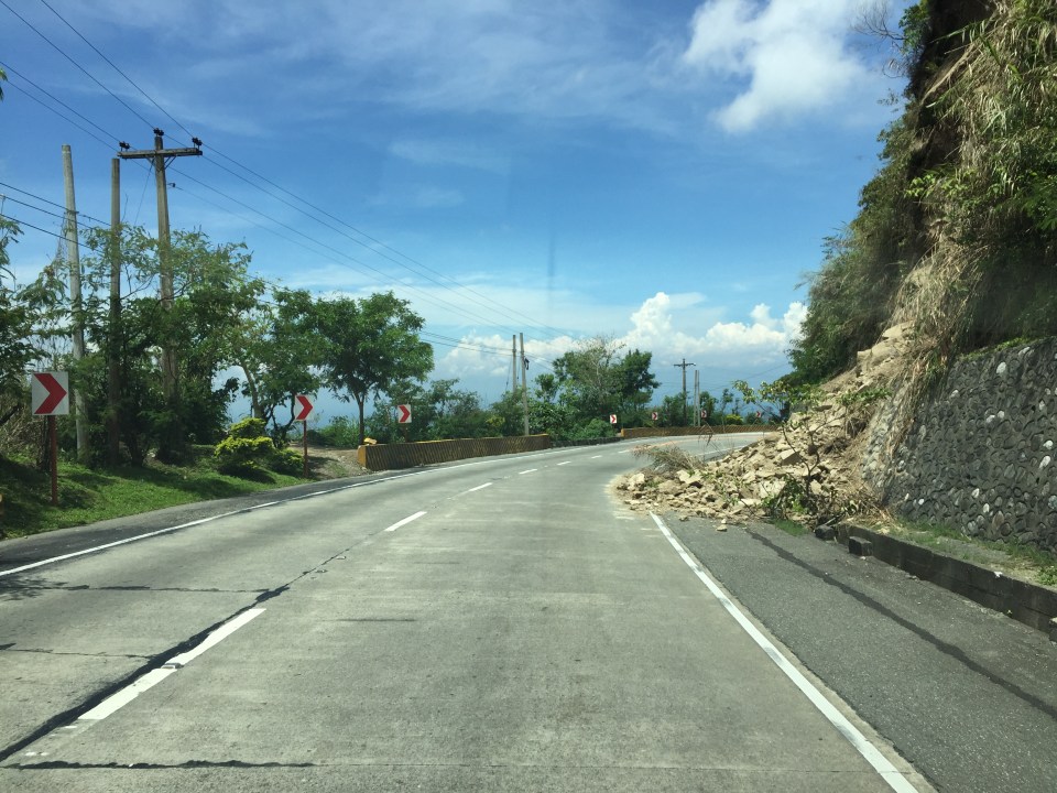
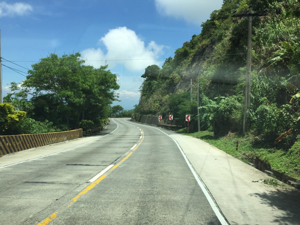
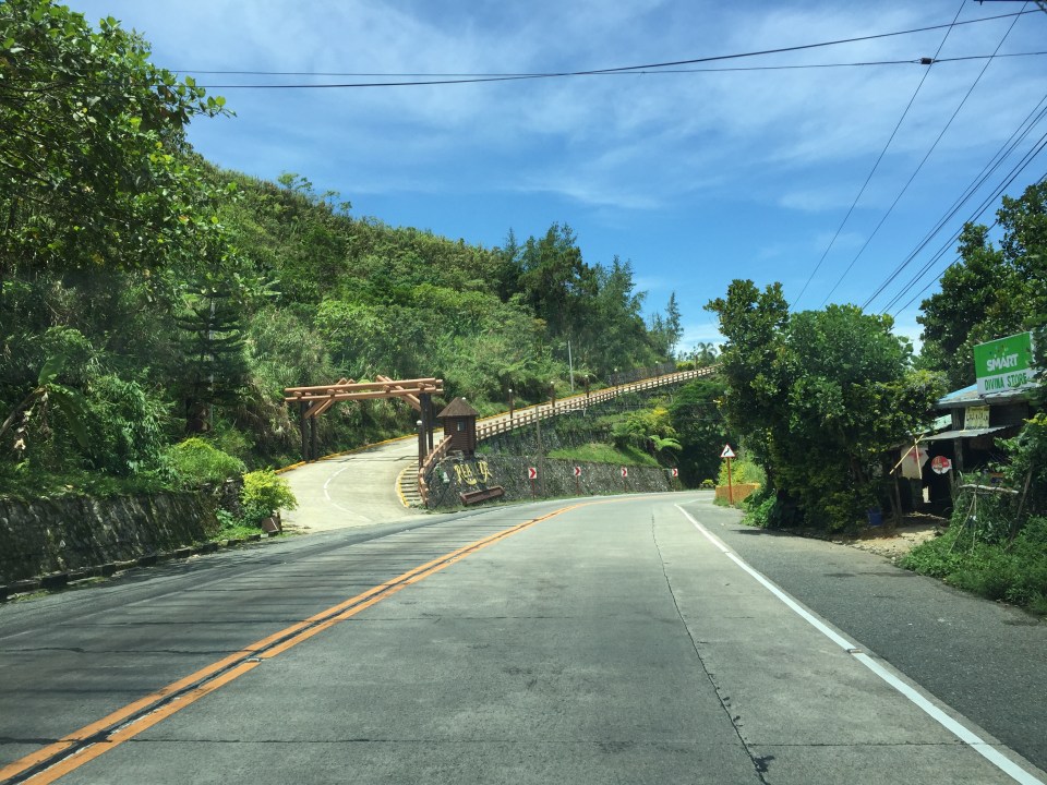
Roads to Baguio: Marcos Highway – Part 3
Still on Marcos Highway, the following photos complete this feature from my most recent trip to a city dubbed as the summer capital of the Philippines. This is the third part of the series on this major road to/from Baguio City, and sections pretty much show very similar characteristics as the previous ones in the preceding posts. Its been a while since the Part 2 of this series and since then, an additional section of the Tarlac-Pangasinan-La Union Expressway (TPLEX) has been opened further cutting down travel time between Manila and Baguio to 4 hours.
 We start with a series of curves. Here is a section complete with signs and markings to guide and protect road users.
 The approach to this curve reveals the uneven terrain on which the road was built.
 These row houses and their driveways seem too close to the road
 That’s a poorly placed driveway right in the middle of the curve
 Many motorists tend to overtake slower moving vehicles via the opposing traffic lane. Here is a bus undertaking a passing maneuver at a curve!
 Rockslide – these are frequent along mountain roads such as Marcos Highway. They are even more frequent along Kennon Road and Naguilian Highway.
 Yet another section this time showing a reverse curve.
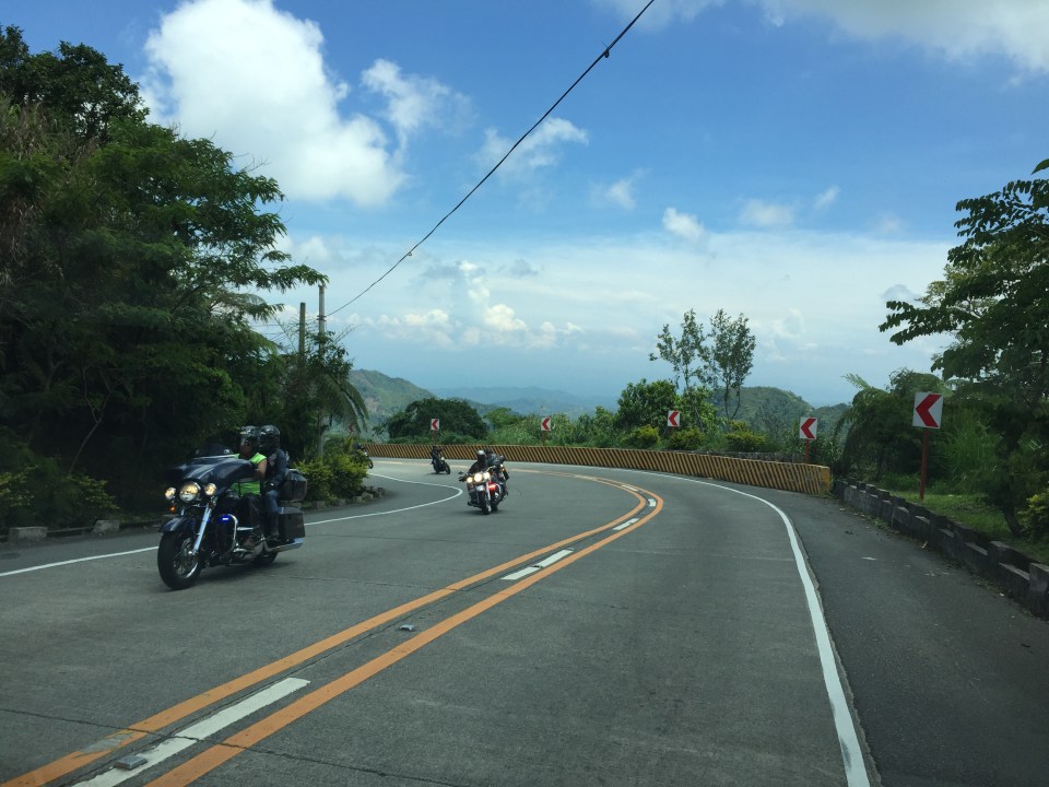 Here are a few more of the big bikes we encountered on our trip down from Baguio. These are of the same group of bikers in Parts 1 and 2.
 Many sections of Marcos Highway have excellent sight distance and have usable, paved shoulders.
 There is significant truck traffic along Marcos Highway. These, especially the loaded ones, often slow down traffic. In certain cases, trucks form platoons making it difficult to pass them.
 I was not surprised to see a school along the highway since there are many communities along the road. This is a good example of standard signs and markings including a pedestrian crossing.
 The curve is not a good location for a home.
 The pavement at this section is intriguing as the road seems to have had a different orientation in the past. I suspect this was formerly a paved bay (for emergency stops or for loading/unloading passengers) in what used to be an unpaved shoulder.
 The position of this driveway is quite risky and motorists from both the highway and the driveway will be blind to each other.
 The section shows also what looks like a bay along the inner (left in the photo) side of the highway. Note that the shoulder is rather narrow along the ridge-side (right).
 Curve sections like this offer picturesque views but are actually are treacherous. The barriers are supposed to prevent vehicles from ‘flying’ out of the highway. Their designs should arrest large, heavy vehicles that may lose control and collide with the barriers.
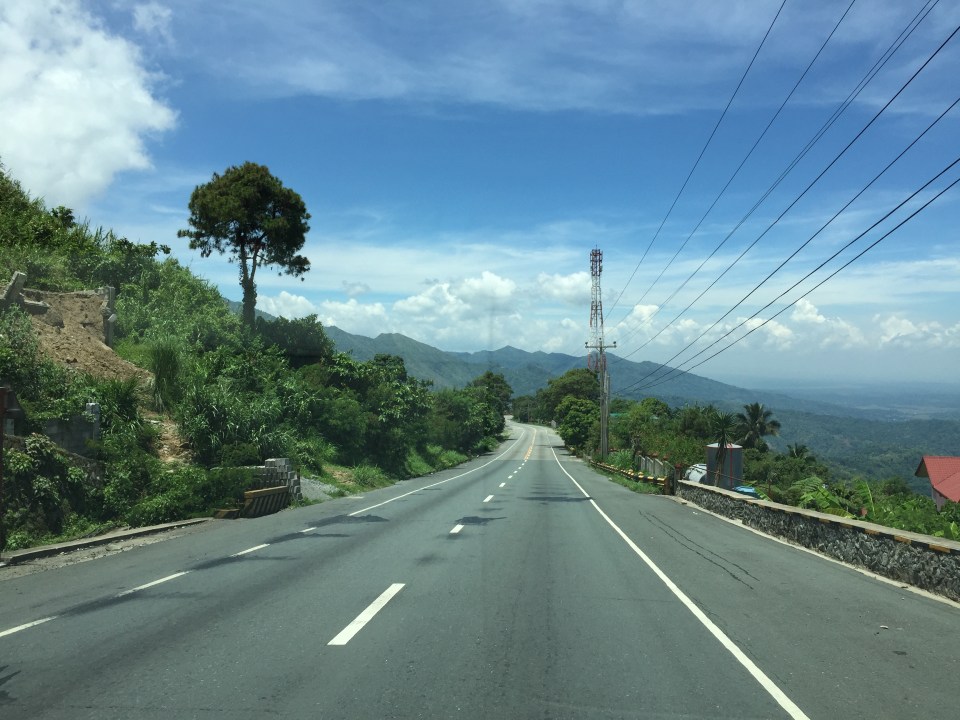 Marcos Highway offers many breathtaking views and excellent sight distance along many portions.
 This is the final stretch of Marcos Highway that terminates at the intersection with the Manila North Road, which is part of AH-26.
–
Road and drainage works along Soliven Avenue, Antipolo City
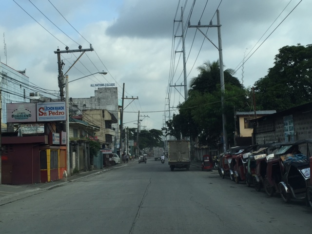
Traffic has been quite terrible for people living along the Marcos Highway corridor and it doesn’t help that one option via Marikina is also currently congested. I am talking about the stretch of Sumulong Highway between Masinag and Soliven Avenue, which is currently being rehabilitated with drainage and pavement works. The work seems to be progressing but not as fast as most commuters would want it to be. Complicating things are more serious road and drainage works along the Antipolo section of Soliven Avenue. This has rendered the street to become one-way and from what I have seen, work here is proceeding much more slowly (perhaps excruciatingly for those residing or working along this stretch). Following are photos I took of Soliven Avenue from the intersection with Sumulong Highway to the border with Marikina City where Soliven Ave. becomes Lilac Street. I won’t put any labels anymore and let the photos speak for themselves.
 1
1  2
2  3
3  4
4  5
5  6
6  7
7  8
8  9
9
Hopefully, these road and drainage works can be completed very soon and would allow for the alleviation of traffic along these roads and the alternate route between Antipolo and Quezon City via Marikina. Such will also help ease congestion along Marcos Highway.
–
Mainstreaming e-trikes?
The big news on electric vehicles in the Philippines today is about what the City of Manila has announced as a phaseout of tricycles and pedicabs (i.e., motorized and non-motorized three-wheelers):
Manila will say goodbye to old school tricycles and pedicabs on October 15
According to the article, these will include conventional tricycles, kuligligs (bicycles fitted out with motors or generators + sidecar), and pedicabs. Manila has thousands (about 25,000 according to the article) of these plying roads where they are not supposed to be (tricycles and pedicabs are prohibited by law from traveling along national roads especially as public transportation). From the article, it seems to me that the date mentioned will be the start for a pilot in the Binondo area. No details are given as to how exactly the local government of Manila will be going about replacing 25,000 tricycles, kuligligs and pedicabs with 10,000 e-trikes, including how the e-trikes will be financed and what will happen to the phased out tricycles and pedicabs. We are, however, hopeful that Manila will be successful and perhaps be a model for other LGUs to emulate.
–
Is Antipolo ripe for high capacity and premium transit services?
About 5 years ago, I wrote about transport in Antipolo in another blog. The article was more about this old city being a major destination attracting people for pilgrimage (Shrine of Our Lady of Peace and Good Voyage) and tourism (e.g., Hinulugang Taktak). I am quoting from that article from 5 years ago and adding a few comments here and there. Note that for most of the article, nothing much has changed except perhaps that the Line 2 extension from Santolan to Masinag is now underway.
“There are now many ways from Metro Manila and its neighboring provinces to Antipolo, although several of these eventually merge into three main roads en route to the Shrine. One is via the old route along Ortigas Avenue, a second is the route via Sumulong Highway, and the third is through a “back door” via the Antipolo-Teresa Road. Routes from the general areas of Manila, Makati, Pasig, Mandaluyong, Taguig and the southern cities of Metro Manila and towns from Laguna, Batangas and Cavite will most likely merge to Ortigas Avenue. Meanwhile, people coming from Quezon City, Caloocan, Marikina, Bulacan, Pampanga and the northern Rizal towns of San Mateo and Rodriguez (Montalban) will likely converge along Sumulong Highway. Meanwhile, those coming from the east including the Rizal towns like Tanay, Teresa, Morong, and Jala-jala, the Laguna towns like Paete, Pakil, Pangil, the Quezon towns of Luisiana, Lucban, Infanta and General Nakar, and others will most likely take the Antipolo-Teresa Road that climbs from the east of Antipolo. People from Marikina, Cainta and Pasig generally may take either the Ortigas or the Marcos Highway/Sumulong Highway route.”
I didn’t mention there that another backdoor was via Marcos Highway if one were coming directly from Tanay instead of through Teresa. This route is now popular and traffic has been steadily increasing due in part to some additional attractions in that part of Antipolo and Tanay.
“Public transport to Antipolo these days include mostly jeepneys as the city is the end point of many routes – a testament to its importance even as a reference point for public transportation. One can easily spot the Antipolo-Cubao jeepneys in the Araneta Center in the Cubao business district in Quezon City. There are two lines, one via Cainta Junction (where jeepneys eventually turn to Ortigas Avenue) and another via Marcos Highway, turning at the Masinag Junction towards Sumulong Highway). Another terminal is at the EDSA Central near the Ortigas Center in Mandaluyong where Antipolo-Crossing jeepneys are queued. And still there is another, albeit somewhat informal terminal near Jose Rizal University (JRU, which was formerly a college and hence the old JRC endpoint), which passes through Shaw Boulevard, Meralco Avenue and eventually turns towards Ortigas Avenue. Other jeepneys from the Rizal towns all have routes ending in Antipolo Simbahan, referring to the shrine.”
There are also UV Express and shuttle vans (legitimate vans for hire or colorum operations) offering express trips between Antipolo and the same end points of Cubao or Crossing. Others go all the way to Makati in the Ayala financial district. These evolved out of the Tamaraw FX taxis that started charging fixed fares during the 1990’s and competed directly with the jeepneys. These are popular, however, with office employees and students during weekdays and the nature of their ownership and operations do make them serious competitors to the jeepneys even during the merry month of May (fiesta period) and the Lenten Holy Week.
“There was an Antipolo Bus Line before. These were the red buses that plied routes between Antipolo and Divisoria in Manila. These died out sometime between the late 80’s and the early 90’s probably due to decreasing profitability and likely because of its competition with the jeepneys. That bus company, along with the green-colored G-Liners, the red EMBCs (Eastern Metropolitan Bus Co.) and CERTs, and the blue Metro Manila Transit Corp. buses used to form a formidable mass transport system for Rizal and the eastern towns of Metro Manila. There were even mini-buses (one I recall were the Antipolo “baby” buses and those that plied routes betwen Binangonan and Recto with the cassette tapes stacked along the bus dashboard). Most of these, except the G-Liners eventually succumbed to the jeepneys.”
At present, there is another bus company operating along Ortigas Ave and the Manila East Road – RRCG. There is also a revival of the EMBC with buses providing transport services between Quiapo and Tanay. The only other bus is the inter-provincial Raymond Transit, which operates between Crossing, Mandaluyong and Infanta, Quezon via Antipolo, Teresa, Morong and Tanay.
“In the future, perhaps the jeepneys should give way to buses as the latter will provide a higher level and quality of service along Ortigas Avenue and Marcos and Sumulong Highways. Already in the drawing boards is a plan to ultimately extend LRT Line 2, which currently terminates at Santolan, Pasig, to Masinag Junction and then have a branch climb along Sumulong Highway and terminate near the shrine. This will bring back the trains to Antipolo and would surely make the church and the city very accessible to people. I look forward to these developments both in my capacity as a transportation researcher-engineer and a Catholic who also visits the Shrine to pray for safe travel for loved ones and myself.”
This proposition for rationalizing public transport to/from Antipolo and other towns of Rizal plus Marikina is all the more important as the Line 2 extension from Santolan, Pasig to Masinag, Antipolo is currently underway. There is an opportunity here to upgrade public transport following the hierarchy of transport modes. I have noticed, for example, electric and conventional tricycles providing what are basically feeder services but along Marcos Highway between Cogeo and Masinag. And a lot of people have been stranded or have difficulty getting a jeepney or UV express ride along the Marcos Highway corridor. I am aware that the DOTC in the previous administration was mulling an express bus service through Marcos and Sumulong Highways terminating and turning around at Robinsons Place Antipolo. That, of course, never happened but is something that I think is worthwhile and would be beneficial to a lot of commuters.
–
Motorcycle lanes along Sumulong Highway?
I noticed something along my commute and that is the newly marked pavement along Sumulong Highway at the section in Barangay Mambugan until Barangay Mayamot at Masinag Junction. I guess this is more likely part of Antipolo City’s initiative in managing motorcycle and tricycle traffic. In a meeting with the City Administrator, Robert Nacianceno, last year, he said that the city was moving towards improving road safety. That included addressing concerns about tricycle and motorcycle operations that has led to crashes and congestion. Motorcycle lanes designated by blue pavement markings are not new and likely was inspired by the MMDA’s initiatives along major roads in Metro Manila.
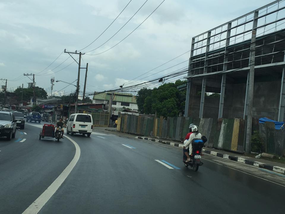 Motorcycle running along the designated lane
 The blue markings are present along both sides of Sumulong Highway
The real challenge with these motorcycle lanes would be on the enforcement. That is, how would the city be ‘encouraging’ motorcyclists and tricycle drivers to stick to the outer lanes of the highway. Such would require a tremendous effort for the city as they will definitely have to apprehend erring motorists and also clear the designated lanes of obstructions. Should this program be successful along Sumulong Highway, perhaps they should consider the same for Marcos Highway.
–
Emergency powers to solve PH transport problems? – A long list of projects
I am sharing the long list of projects submitted by the Department of Transportation (DoTr) to the Senate Committee on Public Services chaired by Sen. Grace Poe. This is a public document and I think should be circulated for transparency and so people will know what projects are proposed to be covered
List of sectoral projects that the Department of Transportation intends to implement and draft bill for emergency powers: dotr-list-of-projects-and-draft-bill
I leave it up to my readers to determine which among the projects listed really require emergency powers. Many I think do not require emergency powers especially since the period requested for such powers is 2 years and not the duration of the current administration’s term. Perhaps those requiring emergency powers would be programs and projects aiming to overhaul our public transport system, which is currently much dependent on road-based modes. Public transportation services do not follow the suitable hierarchy as seen along major corridors served by low capacity modes. An overhaul (i.e., rationalisation) will touch the very sensitive nerves of bus, jeepney, UV express and tricycle operators and drivers and could trigger an avalanche of TROs to prevent or discourage government from doing what should have been done decades ago to bring order to our chaotic transport. I believe emergency powers coupled with the current admin’s political capital (and the “action man” image of Pres. Duterte) can help bring about genuine reform (and change!) to transport in our cities.
–
Monorail in Manila? A proposal in 1969
I am involved in an inter-disciplinary research program with the Third World Studies Center and the Department of Geography of the University of the Philippines Diliman’s College of Social Science and Philosophy. I am very impressed with my co-researchers being able to find a lot of material including tons of stuff on the Manila tranvia from the National Archives of the Philippines. These are currently being scanned and electronic compilations relevant to the program will eventually be made available as part of the deliverables of the projects.
One of the materials they found was a report on a proposed monorail system in Manila. What we first thought was a single line from an old news report that researchers found turned out to be a network. Here is an excerpt of the report on the proposed monorail system in 1969.
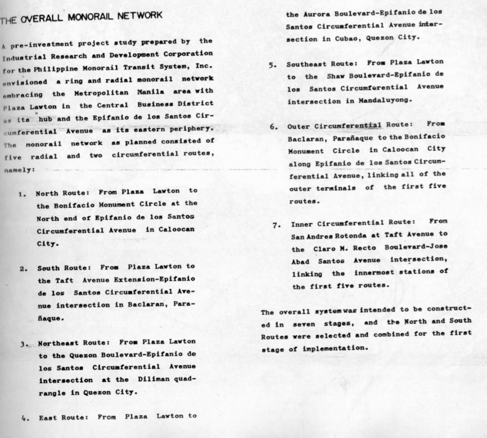
I am posting this snapshot of the monorail report partly for readers to be able to grasp what was going on in terms of public transport planning decades ago. This hopefully allows us to have a firmer grasp of issues behind why public transportation in Metro Manila is so bad. This is given the so many opportunities we had in the past to have something that could have laid the foundation for a more efficient system. While this may be interpreted as some as fault-finding, I would rather look at it as an exercise in learning from a past where a lot of fateful decisions were made regarding both road and rail transport, many of which we now know were unfavorable to public transport and its users, the greater majority of the commuting public. Hopefully, too, this post can generate healthy discussions to point the way forward in improving public transport not only for Metro Manila but other Philippine cities as well. While we can imagine what we could have had now if such systems were realized, we can still look forward to what we can actually have (and for the next generations to benefit from) if we do act towards a better transit system for our cities.
–
