
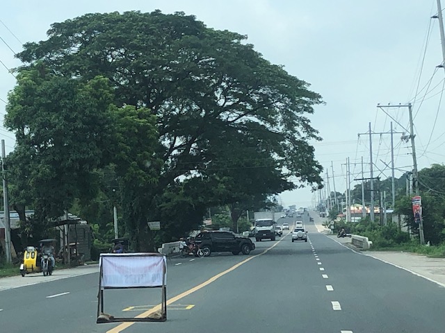
The wide Roman Highway, Bataan
As it is National Heroes Day today, I thought it would be nice to feature a road in an area that witnessed the experiences and sacrifices of many heroes. I traveled to Bataan last July and took some photos of the roads there including the Roman Highway, which is the main corridor connecting many of the province’s major towns. Also called the Roman Superhighway, the highway originally had 2 lanes (bi-directional and undivided) with shoulders along both side of the road. Eventually, it was widened and extended to 4 lanes (2 per direction) with wide shoulders. The current Roman Highway has been expanded to 6 lanes with shoulders but for most parts appear to effectively have only 4 lanes and paved shoulders.
 The wide Roman Highway does not carry much vehicular traffic
 The road widening is not complete as most bridges have not been widened. These produce bottlenecks like the one in the photo where the additional lane is effectively relegated to a shoulder.
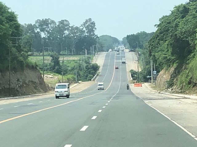
 The highway is practically straight but presents many examples of sags and crests. For those into highway engineering, images like the ones I share in this post are textbook examples for sight distance topics.
 Another sag vertical curve with a bridge near or at the lowest point in the sag. Again, notice that the additional lanes are currently discontinuous at the bridge and there’s a barrier (orange) to warn motorists and guide them back to the original carriageway.
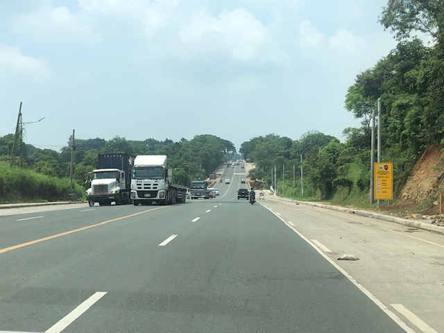 The highway is used by many trucks as there are industrial centers located along the highway including the PNOC in Limay and what used to be called the Bataan Export Processing Zone (BEPZ now the Bataan Freeport) at the end of the highway in Mariveles.
 The widening of the Roman Highway includes the addition of one lane per direction and a narrow shoulder just before the sidewalks. The shoulder could easily be configured into a bike lane but that third lane can easily be designated for bicycles considering the traffic is usually light at most sections of the highway.
 A section where the bridge has already been widened features 3 wide lanes per direction. The shoulders are still there but are not included in the bridge.
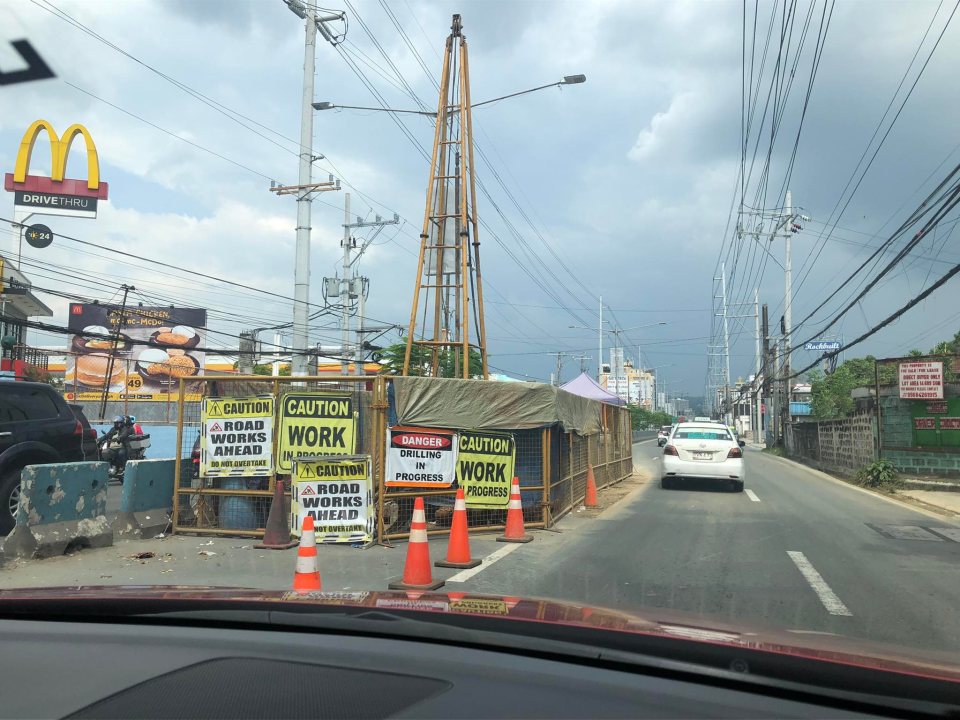
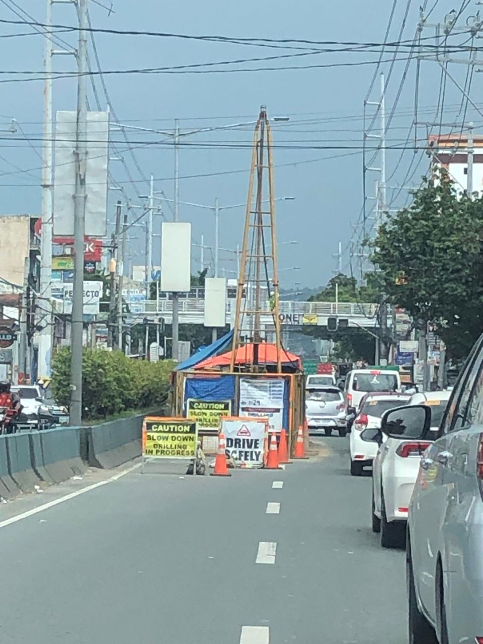
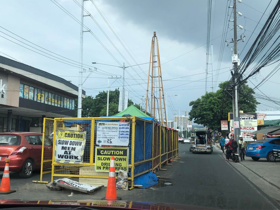
 LGUs are joining the No-Contact Apprehension bandwagon
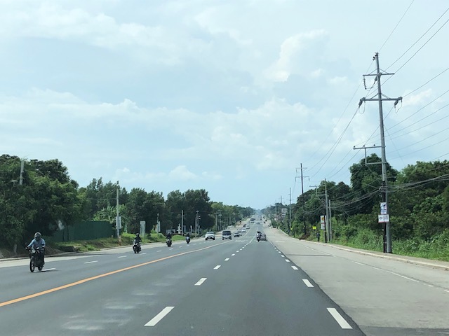 Another view of the wide highway
More on Bataan roads in a future post. I also took photos of the Gov. J.J. Linao National Road (Pilar – Bagac Road), which is the main access road to the Mt. Samat Shrine.
–
How my students see transport and traffic
With social media and the ascendance or popularity of influencers and the like, we have often encountered assessments or opinions about transportation and traffic. While there are those that make sense, there are more that are of the rant variety. The latter include the self-righteous who seem to relish bashing professionals and government officials while not being able to present much in terms of their own accomplishments. I am aware of my students (including research advisees) being aware of these people and I often see them posting their comments on topics, articles and opinions being shared on social media. For most, their comments and posts on social media show they’re being more informed than most, especially about the state of transportation in the country.
Here are some observations and comments from my students:
- One of my students asked me about my take on the public transport situation. I replied that it is unfortunate that public transportation has deteriorated the way it has for the past decades. The current state is not due to recent policies or regulations but a product of various policies, regulations and even trends over so many years. My student countered that perhaps the current officials must not make an excuse of the past in failing to act in the present.
- I always read about posts that anchor their arguments on the supposed low car ownership in Metro Manila. These are usually followed by calls for taking lanes away from car use for public transport and cycling. While I agree with the latter, I don’t with the former arguments. A student was curious about my statement in one lecture that we need to validate the numbers because what we see on the streets appears to be inconsistent with the notion of low car ownership. There are other ways, she said, to determine vehicle ownership other than the conventional HIS data. We could probably use the Family Income and Expenditure Survey (FIES) that is regularly conducted by the Philippines Statistics Authority (PSA). This will show if people own motor vehicles as well as how much they spend for transportation.
- I asked my students to critique the plans and implementation of airports in the Greater Capital Region (GCR) also known as Mega Manila, and which is larger than the NCR Plus used to refer to Metro Manila plus Bulacan, Rizal, Laguna and Cavite. I was not surprised about their assessments as all of them did their homework in the sense that they researched on information and data they could use for their critiques. Most were in favor of developing a new capital airport in Bulacan rather than in Cavite. And many favored the continued operation of NAIA but with reduced air traffic and a different role.
More on these opinions, observations and comments as I try to recall the more remarkable or notable ones.
Have a nice Sunday!
–
On the impacts of bicycle use
I’ve probably read a lot of posts on social media advocating for bicycle use. Here is another article that provides us with evidence about the impacts of cycling on travel, emissions and health:
Timmer, J. (August 20, 2022) “Here’s What Happens When Countries Use Bikes to Fight Emissions,” Wired, https://www.wired.com/story/bike-more-curb-global-emissions/ [Last accessed: 8/24/2022]
To quote from the article:
“Globally, adopting a Danish level of bicycle use would reduce annual emissions of CO2 by 414 million metric tons, approximately equivalent to the UK’s emissions in 2015. Boosting that to a Dutch level would eliminate nearly 700 million metric tons, or most of the emissions from Germany in that year.
The researchers also noted that countries like the Netherlands and Denmark have much lower rates of obesity than their peer countries. Based on the known health risks there, they estimate that, globally, we’re already avoiding 170,000 deaths annually due to cycling. Expanding this globally, they found that Denmark-equivalent bicycle use would prevent 430,000 deaths per year. Dutch levels of cycling would prevent 780,000 deaths.
That said, the vulnerability of cyclists to cars poses its own lethal risks. But these aren’t anywhere close to outweighing the benefits from exercise and lower obesity. (They’d add about 90,000 and 160,000 additional deaths per year for the two levels of use.) And if fewer drivers are using cars, there’s a chance that those numbers would come in even lower.
It’s worth noting that these numbers almost certainly underestimate the benefits of shifting to bikes. Bicycles use far fewer resources to produce, and they last longer than most cars. Maintenance is likely to be far less resource-intensive as well. So simply focusing on the use of the bike omits a lot of things that would show up in a detailed life-cycle analysis.
The researchers are certainly correct that there are a lot of locations where weather makes cycling a less-than-ideal option—and the range of places where heat makes it a positively dangerous option is expanding in our changing climate.
But some of the other issues are less severe than they might appear at first. For example, the advent of bicycles with electric assist means that hilly locales aren’t necessarily the barrier they might have been a decade ago. And while a number of countries have large open spaces where cars will remain a necessity, the trend toward urbanization means that most people in those countries will live in places where cycling can be made an option.
So, the biggest barrier is likely to remain the social will to rethink transportation.”
Indeed, social will (as well as political will) is perhaps the biggest barrier in our country. Many people may not agree but the evidence for this is so clear and obvious that one has to be naive or oblivious to not see it. How else will one explain people sticking to their cars and more readily shifting to motorcycles rather than the bicycle. Of course, there are other factors to be considered and the article actually cites wealth and geography as strong prerequisites in developing a cycling culture. We need to do much more to determine where interventions are needed including land use planning and land development as well as the provision of affordable housing closer to workplaces, schools, shops and other places of interest (Hello 10- or 15-minute cities!).
–
MRT 4 on the way – a monorail along the Ortigas Avenue corridor
I’ve seen and read articles and discussions about the proposed MRT Line 4 along Ortigas Avenue. I’ve written about having a mass transit line along this corridor in the past as it is one of my alternate routes between our home and my workplace. The Line will have the following stations (based on the news articles that came out):
- Taytay – likely at the junction near the Taytay Public Market;
- Manila East Road – likely near SM City Taytay;
- Tikling Junction – major transfer station for those going to Antipolo and beyond;
- San Juan – (future/provisional station) near Valley Golf; will probably materialize when Sierra Valley is completed and occupied;
- Cainta Junction – major transfer station for those heading towards Marcos Highway;
- St. Joseph – likely near or across SM City East Ortigas;
- Rosario – major transfer station for those going to Pasig, Marikina and even Quezon City
- Tiendesitas – (future/provisional station) possible transfer for people traveling along C5;
- Meralco – likely near the Meralco main gate;
- EDSA – likely across Robinsons Galeria and another major transfer station;
- Greenshills – likely across Virra Mall;
- Bonny Serrano – likely near the junction and transfer for people heading towards Camp Crame; and
- N. Domingo – end station connecting to Line 2 at Gilmore.
Following are photos of the current soil test locations for Line 4, all of which are along the eastbound side of Ortigas Avenue Extension between Cainta Junction and Tikling Junction:
 Soil test across the former G-Liner
 Soil test near Brookside
 Soil test before Valley Golf near Mandaue Foam
 Soil test just after the junction with Valley Golf across from the Primark commercial center.
I will not be commenting on Line 4 and its being a monorail at this point. I will probably be writing about this and the idea of having cable cars for Rizal in another post.
–
On university-community collaborations
I’m not a stranger to university-community collaborations. In fact, I even helped draft a proposal for the World Bank to support such collaborations, which I believe would be sustainable and therefore worthwhile to be pursued by potential partner universities and local government units. There are actually many such collaborations but most of these are probably informal with certain faculty members of universities (usually state universities or colleges) being involved in committees or moonlighting in projects implemented or funded by LGUs. I say informal because technically, the school is not involved in the project and it is only incidental that the person or persons involved are affiliated with the university or college.
Here is an article showing an example of university-community collaborations:
National Institute for Transportation and Communities (2022) “Transportation recovery after disasters: A collaborative university/community model,” phys.org, https://phys.org/news/2022-08-recovery-disasters-collaborative-universitycommunity.html [Last accessed: 8/15/2022]
The authors wrote about actions that could be done “to build future economic resilience.” To quote from the article:
-
Increasing pre-disaster investment in resilient transportation infrastructure to reduce the cost of eventual recovery;
-
Improving business resilience practices for high-impact industrial sectors, through education and outreach;
-
Identifying structural barriers to adoption of resilient business practices, and promoting mitigation through recovery.
-
Mainstreaming disaster resilience into economic development by breaking the siloed approach to emergency management and economic development.
While these actions were framed for the community engaged by the University of Utah, they are general enough to be applicable to other communities as well.
I mentioned earlier about the need for formality. The Commission on Higher Education (CHED) encourages and supports what are termed as Extension Works or Extension Projects by higher education institutions. These may be in various forms including committee work, advisory, capacity building/training, or even professional work/services provided to the province, city or municipality (even barangay). But there should be accountability here as well as the proper assignment or allocation of resources.
Just compensation is one of the more sensitive or tricky elements or items here as often, LGUs would like to get something for free or assume that certain services are free. They are not and time and effort should be compensated; just not the international rates you might expect for consulting work from the likes of World Bank or Asian Development Bank.
Here is where contracts (e.g., in the form of Memorandum of Understanding (MOU) or Memorandum of Agreement (MOA)) can be useful to establish the terms of engagement that includes budgets for Personnel Services (PS), Equipment Outlay (EO) and Maintenance and Other Operating Expenses (MOOE). The latter categories should be familiar with LGUs because these are standard items under which details are provided for their programs and projects. State universities and colleges are also familiar with these as standard government terminologies for budgets. Of course, that goes without saying that in certain engagements, there may be third parties such as donor or funding institutions that will should all, most, or part of the costs for collaborative work.
–
Opinions on the current transportation situation?
Some people were asking me about what I thought about certain issues and reports on transportation. To be honest, while I am involved in some projects including one on road safety, I have been busy (or swamped is probably a more suitable term) with administrative duties at the university. While I take a peek from time to time, as is my habit, to see what’s happening, I have much less time to really engage or get involved in discussions. Whereas before, I easily get myself into typing comments and engaging in some discussions about transport issues particularly in social media, I now quite easily turn away and let it be. There are, after all, a lot of people experts, pundits, advocates, even trolls who are “slugging it out” with their opinions on just about anything on transport.
While I am amused at many discussions or posts, I now find myself not at all wanting to get involved unlike before. I think perhaps I have done my part and continue to do so in ways and avenues where I am more effective and where my time and effort is not wasted and more appreciated. I have never been the loud person in a room and have always tried to have my work speak for myself.
The indifference is the product of many factors and circumstances including becoming tired of doing interviews with conventional media. Nowadays especially, when media seems engrossed on having content by the minute; never mind the substance. Basta may ma-report or ma-post (As long as their is something to report or post).
Well, here’s a few thoughts about what seem to be trending these days:
- There is still a lack of public transportation supply considering the increasing demand (more people are back to their workplaces and schools are already reopening!). Government agencies still seem to be clueless or perhaps just want to push the original rationalization and modernization programs despite the pandemic changing the game for commuting demand. Due to the lack of public transport, more people are taking to private vehicles but certain observers apparently see only cars (which they automatically equate to ‘private vehicles’). Motorcycles are also increasing in numbers and allowing motorcycle taxis will mean people will turn to these for commuting/transport needs.
- Cable cars won’t solve Metro Manila transport or traffic woes. Even if one will consider where they will fit or may be suitable, this is still a band aid solution considering all the solutions including the ones that are obvious or staring us in our faces (yes, allow the conventional jeepneys and buses back for now) that are available but government stubbornly rejects. As for the senator who broached the idea, I think he did so mainly for media mileage (and the mainstream media quickly snapped it up!) – para mapag-usapan. As they say – it’s so showbiz!
- I still believe that the experiences from the pandemic strongly provide us with the evidence to support a continuation and sustaining work-from-home or remote work set-ups. This actually ‘solved’ traffic during the heights of the pandemic and yet we choose to revert to the old normal set-up. People are languishing, suffering as they spend long travel times in their commutes. These are unproductive time that people could have spent more efficiently and productively (not to mention more meaningful) at home.
- I support children going back to school but not for 100% of their times. We definitely know that a 100% study-at-home set-up is not for everyone and the last two years have affected our children including their need for face-to-face interaction with other children (classmates) and adults (teachers). Still, we can have a blended set-up where perhaps we can have children come to school 2 to 3 days in a week rather than the old normal of 5 to 6 (even 7 in some schools) days. Other tasks and learning activities can be done effectively at home. This also could help ease traffic and travel demand especially in urbanized areas.
More opinions in future posts!
–
Another look at the Zamboanga Airport – arrival
We traveled to Zamboanga earlier last month and it was our first trip to the city since the first lockdowns in 2020. We were supposed to travel in March 2020 to conduct data collection for a full week but then there was the nationwide lockdown implemented to control the spread of the Covid-19 pandemic. If we were already there when the lockdowns were implemented, we could have been stranded at our hotel and perhaps spent a few weeks to perhaps a month before we could return to Manila.
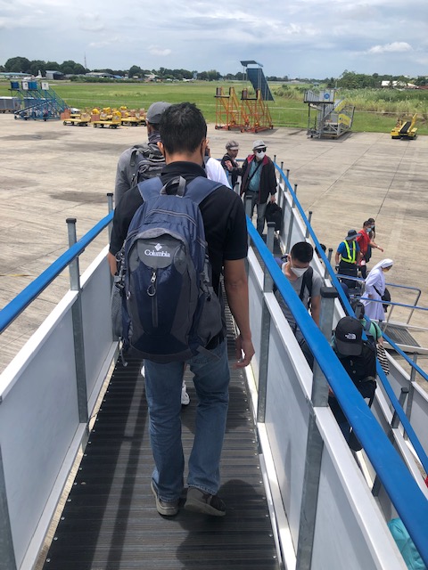 We disembarked from the plan using the more sophisticated and senior citizen- and PWD-friendly ramps.
 It took longer to get down both in terms of distance and disembarking time.
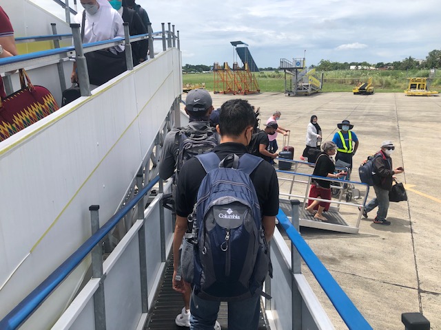 Other stairs and ramps are shown in the background. I recall only Cebu Pacific had these for their aircraft.
 Our first look at the renovated Zamboanga International Airport (Aeropuerto International de Zamboanga in the local language – Chavacano) since February 2020. At the time the roof was already falling apart at different locations.
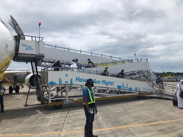 A look back at the ramp
 Passengers walk towards the arrival area of the airport
 The baggage claim area is practically the same as in 2020. The only notables are the signs encouraging physical distancing as well as the stickers on the floor that designated where passengers were to position themselves.
 As you one can see, people no longer really observe social distancing but all are wearing face masks.
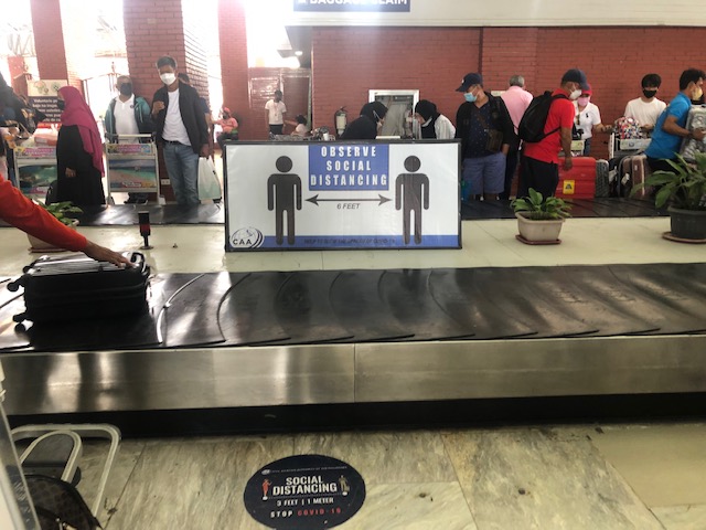 A closer and clearer look at the sign and the floor sticker asking people to practice social distancing
 The main driveway of the airport remains closed to general traffic. This is used only for special occasions and VIPs.
 A look back to the terminal’s arrival area as we walked to meet up with the driver of our service vehicle while in the city.
Photos from the departure/return leg of our trip in the next post.
–
On using advanced tools for infrastructure assessments
I came upon this article on how transportation departments in the US are using tools such as drones to assess critical infrastructure including roads and bridges. This is very relevant to us especially as many similar infra are aging and would need to be assessed to determine how to reinforce, retrofit or even rehabilitate certain infrastructure vs. naturally occurring phenomena like earthquakes and typhoons.
Reed, J. (August 2, 2022) “How Transportation Departments Are Using Advanced Drone Technology for Infrastructure Assessments,” Aviation Today, https://www.aviationtoday.com/2022/08/02/transportation-departments-using-advanced-drone-technology-infrastructure-inspections/ [Last accessed: 8/4/2022]
To quote from the article:
“The WVDOT may expand its drone programs to perform road safety assessments and to assist in designing new road routes by providing topographical maps.”
I recall that there have been road-based surveys involving Lidar to map the road and adjacent land surfaces about a decade ago (maybe less). This was a nationwide project funded by the Department of Science and Technology (DOST) and implemented by the University of the Philippines Diliman’s Department of Geodetic Engineering. I’m not sure where that data is stored or hosted but the DGE should have a back-up somewhere that can be used or further processed for road safety assessment applications. This could be an interesting and fruitful research area that can involve people from various disciplines.
–
On “beautiful” train stations
Here’s another article I am sharing that presents a list of some of the world’s most beautiful train stations. I say some because in my opinion, there are many others that we can consider beautiful according to various criteria and preferences. After all and as they say, beauty is in the eyes of the beholder.
Funderburg, L., Cott, A. and Cherner, J. (August 1, 2022) “The 37 Most Beautiful Train Stations in the World,” Architectural Digest, https://www.architecturaldigest.com/gallery/best-train-station-architecture-slideshow?utm_source=nl&utm_brand=spotlight-nl&utm_campaign=aud-dev&utm_mailing=thematic_spotlight_080122_1&utm_medium=email&bxid=5bd6761b3f92a41245dde413&cndid=37243643&hasha=cf6c402001bc473063a8744033fe9be3&hashb=ec2bb753c2e6299f5107823241955221da67bd1f&hashc=09f65c608bfb62050199733de500e3cd82827631b36d537ce8386d41a3bd1ff7&esrc=FYL_SEG_APR18&sourcecode=thematic_spotlight&utm_term=Thematic_Spotlight [Last accessed: 8/2/2022]
I’ve seen many of these stations particularly the ones in the Netherlands, Australia and the US. The wife also sent me photos of other stations in her travels in Europe and the Americas. But there are many else to include in the list depending on your taste. Southeast Asia has many though perhaps for restoration. Japan definitely has many classic and contemporary/modern designs. And Central Asia should also have many that can be compiled into a list. I wonder what we can include or if there’s something in the future to look forward to in the Philippines.
Here are a couple in my list that aren’t in the article:
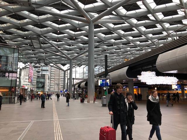 Den Haag Station, The Netherlands
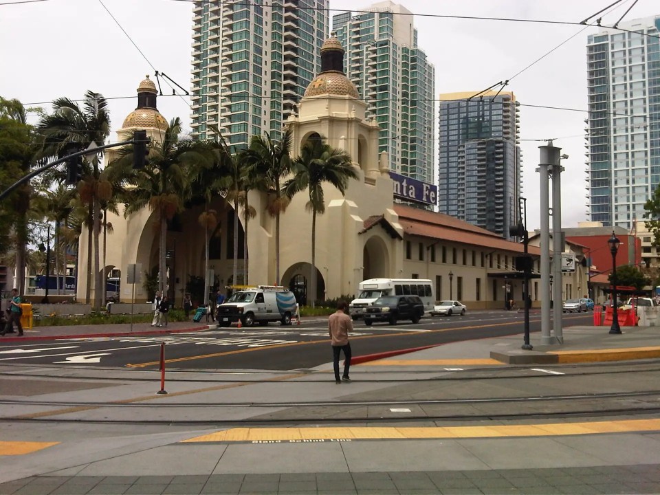 Santa Fe Station, San Diego, USA
–
Free public transportation services?
We start August with an article share. Much has been said and written about public transportation being a basic right for people. And the experiences during this Covid-19 pandemic have shown us just how efficient and adequate public transportation can help make our lives better in terms of addressing our commuting or travel needs. Here is a very informative article that should make sense from the perspective of the general commuting public:
Konbie, N. (July 29, 2022) “The Case for Making Public Transit Free Everywhere,” Wired, https://www.wired.com/story/free-public-transit/?bxid=5bd6761b3f92a41245dde413&cndid=37243643&esrc=AUTO_OTHER&source=EDT_WIR_NEWSLETTER_0_DAILY_ZZ&utm_brand=wired&utm_campaign=aud-dev&utm_content=WIR_Daily_072922&utm_mailing=WIR_Daily_072922&utm_medium=email&utm_source=nl&utm_term=P7 [Last accessed: 8/1/2022]
To quote:
“Free fares might not get everyone out of cars, but will convert some journeys, which benefits everyone in terms of carbon reduction and improving local air quality—and even helps drivers by calming traffic. Free fares won’t pull low-income people out of poverty, but will keep money in their pockets and ensure everyone can travel when they need to. Ditching fares comes at a cost, but there are savings to be had by not investing in expensive ticketing systems and wider logistical and societal benefits…
Public transport should be considered a human right, alongside access to health and education.”
Of course, service quality is a major concern here in the Philippines but isn’t it everywhere else? The question of sustainability should be a rather complex one considering we haven’t truly understood and translated the benefits that can be obtained from providing high quality public transport services vs. being car-oriented. Congestion pricing, for example, could very well provide the funds to improve, upgrade and maintain desirable public transport services (i.e., desirable from the perspective of most commuters and not just the lower and middle income people who more regularly or likely to take public transport than other modes of transport).
What do you think?
–
