
Ferry ride from Darling Harbor to Cockatoo Island
I had an opportunity to ride the ferries going around Sydney including some of the islands that were part of the attractions of the city. We rode a ferry from Darling Harbor to Cockatoo Island, which used to be for shipbuilding and repairs. It was also historically significant not just because of the ships that were built or repaired there but also because it was used as a correctional facility.
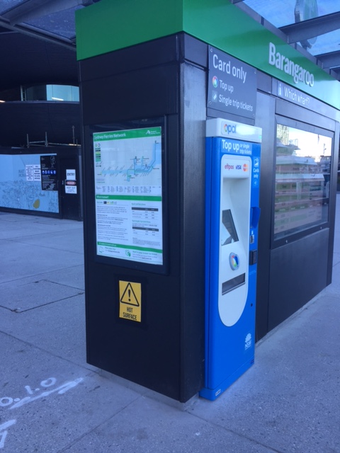 Information and fares – one can get detailed information on ferry services at the wharf and also purchase single trip or top up cards from the machines conveniently located in the area.
 Information on the ferry services including the network and use of Opal cards to pay for your fares
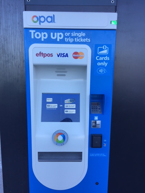 One can use the Opal card to take ferry rides. You can top up (reload) at terminals at the wharf
 The wharf where we were to await our ferry for Cockatoo Island
 Sign showing which ferry lines dock at Wharf 1: F4 is for Circular Quay and F3 is for Parramatta, which includes a stop at Cockatoo Island.
 The arrival of our ferry at the port
 The cabin was practically empty when we boarded the ferry.
 A better look at the spacious cabin
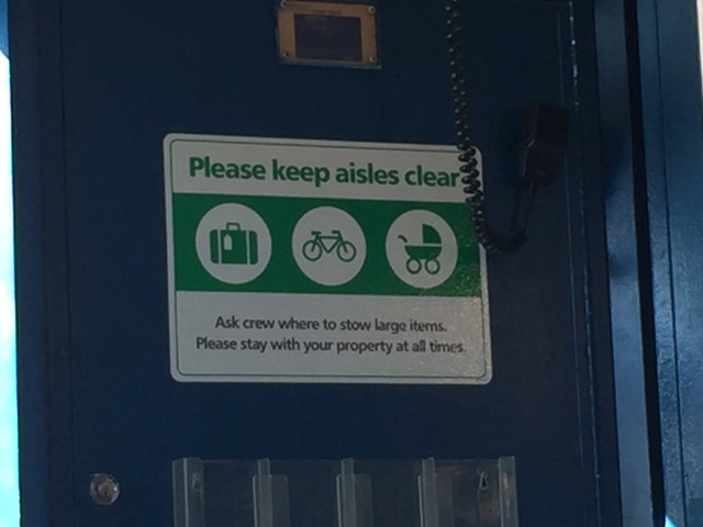 Advisory for all passengers
 Ferry layout and safety plan
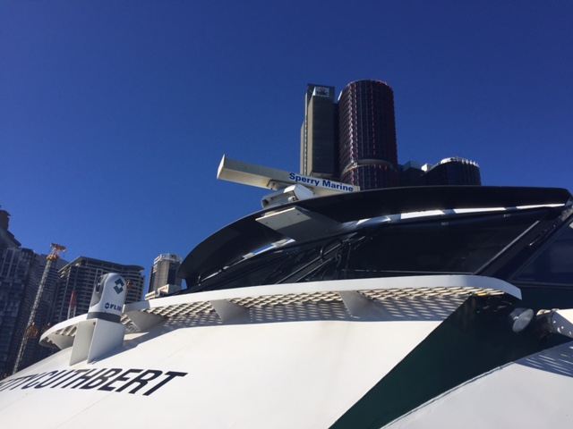 A view of the bridge and showing the name of the ferry. We discovered that each ferry was named after a prominent female sports figure.
Our ferry ride to Cockatoo Island afforded us splendid views of the waterfront properties and landmarks. The ferry also had few passengers so we could go around the boat to have an appreciation of the sights as well as the vessel itself. I will post some photos of the views from the ferry in a future article.
–
Melbourne taxi rides
I took taxis between the airport and the serviced apartment where I stayed at in Melbourne. Both rides were uneventful ones and I enjoyed the good service provided. Uber is also available but Melbourne taxis appear to be providing an obviously higher quality of service compared to what you can get in Metro Manila.
The following photo shows a couple of stickers that inform the passenger(s) about standard fares and the applicable tolls should the taxis use tollways and therefore incur additional costs.
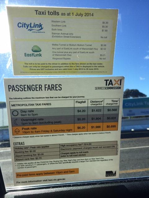
One can pay cash or opt to use a debit or credit card to pay for taxi fares. And you can get a receipt that you can use to account for your transport expenses. That is, the receipt is useful for reimbursements.
For both my rides, I didn’t encounter any unruly taxi drivers. One was a bit chatty but I enjoyed the conversations about life in general. I learned that he was originally from Somalia and had a son studying in university. He said he was very happy with his life in Australia and was thankful of his job that enabled him to support his family including being able to afford to send his children to schools. I guess he is one of the lucky immigrants there and his hard work paid off in this country where the environment generally rewards hardworking people with much opportunities to improve their lot.
Taxi operators and drivers in Metro Manila should learn about what good service is all about from taxis abroad. Perhaps they can pick up a good thing or two for how they can improve services and thereby reducing if nor eliminating the bad impressions people generally have about them that have led to ridesharing services to become quite popular. A significant improvement in taxi services can be rewarding in terms of ridership or patronage.
–
Marcos Highway-Felix Avenue-Gil Fernando Avenue pedestrian overpass
Here’s are some photos of the pedestrian overpass structure at the intersection of Marcos Highway, F. Felix Avenue (formerly Imelda Avenue) and Gil Fernando Avenue (formerly A. Tuazon Avenue).
 Here’s a view of Marcos Highway and the elevated Line 2 Extension from the structure crossing Felix Avenue between Soliven/Tropical and Sta. Lucia. Also shown is the overpass crossing Marcos Highway.
 View towards Sta. Lucia and Robinsons Metro East
 Stairs to Sta. Lucia – notice the gap in the railings along the elevated Line 2 superstructure? That is where the Emerald Station will be constructed.
–
Some thoughts on the ridesharing vs taxi issues in Metro Manila
A lot have been said and written about the issues concerning ridesharing and taxis in Metro Manila. There are the personal posts you read and are being shared around social media. There are the obviously sponsored posts and articles going around. These are usually by trolls but may also include some personalities who are more than willing to lend their names to a cause they think is worth taking on. Unfortunately, the supposed victim here is also an oppressor if one tries to delve into their operations and practices. The real victims here, aside from the commuters who patronize ridesharing, are drivers and operators.
I stated Metro Manila because there seems to be no serious issues on ridesharing or taxis in other Philippine cities. Why is that? Is it because taxis provide better services in other cities like say, Cebu, Davao or Iloilo? Is it because public transport in other cities are better compared to Metro Manila? Or is it because ridesharing companies cannot compete with local, taxi-like transport like tricycles? Let me put it like this: Metro Manila public transport has deteriorated in the past decades. This deterioration comes in many forms including the very slow development of mass transit systems and the continued dominance of road-based modes.
Private vehicle mode shares have increased significantly over the last four decades. In the 1970s, the estimated split between public and private transport was about 75/25. In the 1980s, it was close to 70/30 but with public transport enjoying just about 70% shares. In the 1990s, the 70% had already been breached with public transport share estimated to be about 68%. The 2000s saw public transport shares to have been eroded further, with closer to 65% of trips using public transport. The last decade likely saw the further rise of private transport shares with the rapid increase in motorcycle ownership and use and the emergence of ridesharing such as Uber and Grab. This, despite the increase in population for the metropolis and also the increase in road public transport vehicles particularly UV Express.
These road-based modes are generally low capacity and require so many vehicles to transport so many people. And yet people choose them (e.g., purchase and ride a motorcycle, patronize Uber or Grab, etc.) because their options for their commutes are generally worse off. Motorcycles are not for everyone and not everyone can afford to or want to own a car. And yet, there seems to be a sizable population wanting (not necessarily needing) to be driven to and from their homes, workplaces, schools or other places of interest but not via conventional taxis; as evidenced from the popularity of ridesharing services.
Perhaps the only way to resolve the issue lies not only in the drastic improvement of conventional taxi services. Operators and drivers have had a lot of chances to do this but there seems to be little positive change here. Maybe, and ultimately, the solution is in the expedited development of mass transit systems like rail transit lines and bus rapid transit (BRT). And so the initiatives of the current administration along such infrastructure projects are most welcome and may stave off the decline of public transport mode shares (revival?). Better public transport should help make commutes more bearable. Commutes should be safer, faster and relatively inexpensive compared to owning and operating a car. And may I add that using conventional public transport should be more attractive than ridesharing.
–
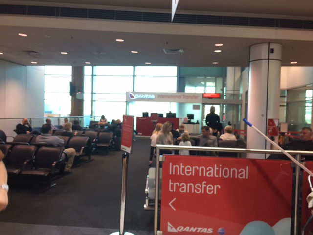
Airport terminal transfer in Sydney
My flight to Melbourne was via Sydney. I chose Qantas because of the more favorable schedule as well as the cheaper fares the schedule provided compared with Philippine Airlines and Singapore Airlines (via Singapore). And so knowing I would have to transfer at Sydney airport, I decided to have more than an hour’s layover there. It turned out to be a good decision as we had to pick-up our luggage, clear customs and then walk over to the transfer area at the international terminal to have our check-in luggage tagged and dropped off before proceeding to ride a transporter (bus) to the domestic terminal. It was also a good thing that Qantas already thought about such transfers and had good facilities and service for such. Needless to say, the transfer was smooth/efficient.
 We had to get our baggage after clearing immigration
 We had to walk towards the Qantas transfer facility to have our baggage tagged and dropped off for our connecting flights. In my case, that was for my journey to Melbourne.
 After dropping off our luggage, we waited to board the bus that would take us to the domestic terminal. The service frequencies are shown in the sign above.
 I was near the front of the line is I was able to board early and take a photo as people were just filling the bus.
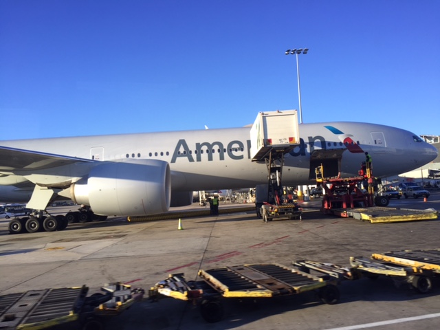 Scenes of aircraft ground operations while we were in transit from the international terminal to the domestic terminal includes this American Airlines jet replenishing on inflight meals.
 Here’s another view of the same jet getting serviced at the airport.
 This is how the bus looks once it fills with people
 This is the scene when we arrived at the domestic terminal. Passengers at the terminal were also waiting to board the bus bound for the international terminal.
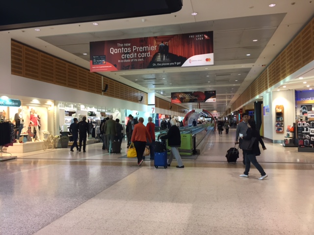 En route to my boarding gate, I took a few photos of the corridor lined with various shops.
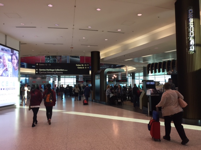 There were also cafes and restaurants for those wanting to have or grab a quick meal or drink.
 I arrived at the boarding gate with much time ahead of my flight. There were, however, many passengers already waiting, too.
 It seems crowded but there were enough seats for those wanting to relax while waiting for the boarding call. Others seem to prefer just standing (healthier?) there. It was still early in the morning so most people were just quiet or conversing softly with fellow travelers. I myself was a bit sleepy and looking forward to taking a nap on the 1.5-hour flight to Melbourne.
–
Topics for transportation research
I notice that I have been getting a lot of traffic on my site lately from people searching about research topics. I guess its that time of year when students (undergraduate, graduate, post-graduate) are looking for topics. I have written before that it seems to me that many schools don’t really provide much guidance to students in their topic selection for their undergraduate research, masters thesis and even doctoral dissertations. I have received and seen emails from students from other schools asking if I or one of my colleagues at the university can be their research advisers. We usually politely decline so as we also have our own students to advise and researches to undertake. While I believe we should encourage research on transportation topics, I would dare say that schools should be responsible enough to build capacity for their faculty to be able to effectively guide their students and not unfairly pass them on to others.
Here are some topics that I think are quite relevant at present:
- Anything that’s about ride sharing (i.e., Uber, Grab, etc.) and particularly on passengers’ and drivers’ characteristics.
- Carpooling as applied in offices, schools, communities. There’s an app that promotes this – Wunder.
- Motorcycle taxis – this includes habal-habal, Skylab and other variations both in the urban and rural setting. What are their characteristics? Passengers? Drivers?
- Complete streets – how can we apply its principles to our cities, towns, communities, even specific roads?
- Road safety – this genre covers a lot of topics including pedestrian safety, motorcycle safety, public transport safety, child safety, driver behavior, safe road designs, etc.
- Transportation costs/expenditures – characteristics of commuting and commuters in relation to the modes they take as well as the distances between their homes and workplaces or schools.
I believe there are a lot of topics that can be developed from the above. But perhaps schools can first formulate research agendas first and not attempt to snipe at every and all topics that come to mind.
Good luck on topic selection and here’s hoping your outcomes are useful to improve transport and traffic in the Philippines.
–
Melbourne’s transit system
One thing I always look forward to whenever I am traveling is to try out the public transport system of the cities I am visiting. My first day in Melbourne gave me an opportunity to familiarize with the city’s transportation including the trams and bikeways. Following are some photos I took as I went around the city center on-board their trams. I actually purchased a myki card but discovered a bit later that tram rides were free when you’re within the zone defining the city center. You only need to swipe or tap when you leave the zone where transit will charge the corresponding fares to your destination.
 Tram passing by the stop where I decided to stand by to take a few photos while familiarizing with the network map.
 Melbourne transit network map and information on priority seats
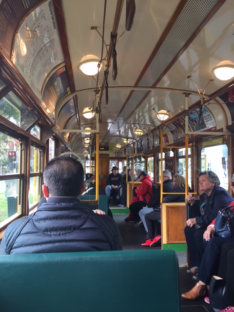 Inside the circle tram that goes around the city center
 Typical transit stop
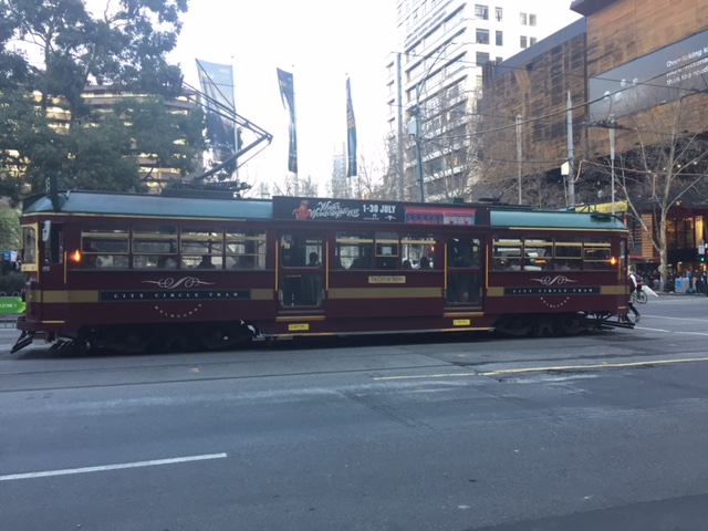 Vintage tram
 Tram crossing an intersection
 Modern transit vehicle
I found Melbourne’s transit to be quite efficient and the coverage was comprehensive enough considering the city was walkable and bicycle-friendly. This meant people had many options to move about and this mobility definitely contributes to productivity. More on transportation in Melbourne and Sydney in future posts.
–
Why do we need to reduce speeds?
A common observation made of Philippine drivers is that they seem to hesitate from slowing down even at hazardous locations or situations. Note, for example, vehicles approaching an intersection and you will observe that many if not most will not reduce their speeds. Most guilty for me are motorcycle riders who tend to maneuver and even speed up instead of slowing down for a safer approach. Slowing down (i.e., reducing one’s vehicle’s speed) is actually a no-brainer and something that is explicit in any country’s traffic rules and regulations and driver’s handbook.
I saw a lecture on why reducing speeds are important. This is not just from the specific perspective of safety but is explained in favor of mobility and quality of life. Here’s the lecture:
Reducing speeds for better mobility and quality of life by CarlosFelipe Pardo
–
Melbourne airport arrival
I traveled to Australia recently to attend a symposium on Sustainable Development in Melbourne. As such, I was able to observe and experience transport in a couple of major cities – Melbourne and Sydney. I arrived in Melbourne via Sydney at Terminal 1, which is for the domestic flights of Qantas. Here are some photos upon my arrival at the airport:
 Upon deplaning, we proceeded through the shared departure areas with the shops and restaurants to go to the baggage claim area.
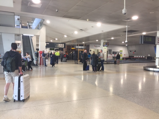
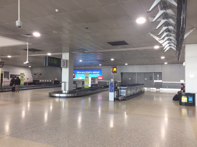 Baggage claim area
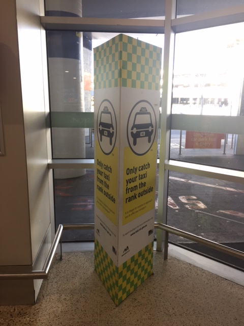 Guidance for those taking a taxi from the airport
 Machine for paying airport parking fees
 Taxi queue at the airport – the queue appeared to be long but there were many taxis so it didn’t take long to get one to the hotel. The airport had staff to direct passengers and taxis to the designated berths.
I will be writing more about transport in Australia in future posts. It is always a good thing to experience transport in cities abroad. And of particular interest for me when I was in Melbourne and Sydney was their cycling facilities so I will also feature those in future articles.
–
Some thoughts on the proposed Metro Manila subway
The detailed design for the proposed Metro Manila subway is supposedly underway. Here’s a graphic of what the system may look like underground. I got this from the American Chamber of Commerce newsletter.
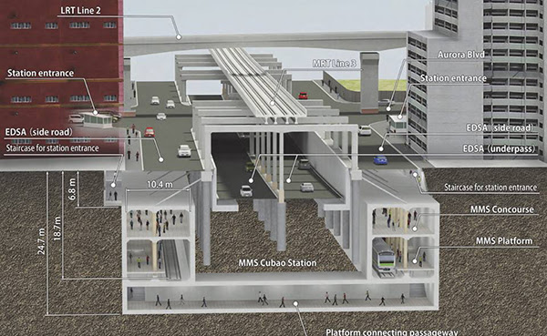
What is not shown, and which I think should also be emphasized, are the drainage tunnels that need to be constructed in relation to the underground transport system. Tokyo’s subterranean drainage, for example, are so extensive and spacious that it could handle the precipitation/runoff during rainy days so its subways are flood-free. Metro Manila stands to benefit much if similar drainage systems are built together with the subway. I think a lot of people can appreciate this feature of the subway nowadays when we all feel the impacts of the intense monsoon rains (Habagat) not to mention the typical typhoons that come our way. The subway’s construction may be seen not only from the transport perspective but also as an opportunity to improve the metropolis’ drainage system.
–
