
On pandemic travel patterns and the future
Here is a recent article on travel patterns as influenced by the COVID-19 pandemic.
Bliss, L., Lin, J.C.F., and Patino, M. (2020) “Pandemic Travel Patterns Hint at Our Urban Future,” Bloomberg CityLab, https://www.bloomberg.com/graphics/2020-coronavirus-transportation-data-cities-traffic-mobility/?sref=ViNyghXi [Last accessed 6/19/2020].
Are these travel patterns similar to those of our cities and municipalities in the Philippines? Or were there a different reactions or outcomes considering local factors including perhaps cultural aspects?
–
On the importance of public transportation post-pandemic
I am sharing another article from Todd Litman that appear yesterday:
Litman, T. (2020) “Lessons from Pandemics: Valuing Public Transportation,” Planetizen, https://www.planetizen.com/blogs/109584-lessons-pandemics-valuing-public-transportation?fbclid=IwAR2jduFuYoyf_MoksI2Th4UoWtQYMQVOdwHuiih8JM9NxMN5pT_e1lwhgDQ [Last accessed: 6/13/2020]
The article contains material derived from previous work by the author and provides a list (and links to) resources or references related to this topic.
–
Traffic is back to “normal”
Traveling to the office last Monday, I could not help but notice the long lines of cars along Ortigas Avenue’s westbound lanes and Katipunan’s southbound lanes. Without adequate public transportation, people have few options for their commutes. Walking from home to workplaces is feasible only for those who live relatively near their workplace (perhaps up to 5km distance?). Cycling may be considered but not everyone can bike beyond 5km, what more for 10km+ commutes. And for both cases, there are just so many obstacles (and I’m not just fault-finding here) like a lack of sidewalks and bike paths to ensure safe walking and cycling.
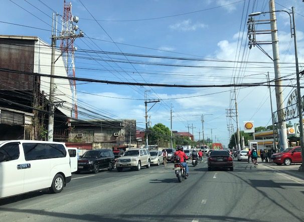 Traffic congestion along Felix Avenue in Cainta towards Cainta Junction (with Ortigas Avenue Extension) – these are mostly outbound traffic likely coming from the residential subdivisions along Felix Avenue and heading to workplaces in Pasig, Mandaluyong, Makati and Taguig. They will likely take Ortigas Avenue to connect with other major roads such as C-5 and EDSA to get to their destinations.
The DOTr and the LTFRB have released guidelines for safety and the prevention of the spread of the COVID-19 virus. Yet, they have moved quite so slowly to bring back public transportation to address the demand for it and to be able to discourage or restrict car usage in the “business-as-usual” or “old normal” sense. Public transportation is critical if we are to transform transportation during this transition from the lockdowns. Granted, the government probably wants to use the situation to effect its modernization plans but it is one thing to take advantage of the opportunity and another to be an opportunist considering the vulnerabilities of the transport sector after it endured 3 months of shutdown. The moral and right thing to do is to bring back public transport and give incentives for it to thrive and perhaps transform or upgrade by themselves rather than force the situation at the expense of commuters.
–
Are face shields to be recommended for pedestrians and other commuters?
Here are some references regarding the use of face shields. Again, I post these here also for my easy reference whenever I need to search for such in the work I am doing or will be doing.
- Perencevich, E.N., Diekema, D.J. and Edmond, M.B. (2020) “Moving Personal Protective Equipment Into the Community – Face Shields and Containment of COVID-19,” JAMA Network, https://jamanetwork.com/journals/jama/fullarticle/2765525 [Last accessed: 5/25/2020]
- Lindsley, W.G., Noti, J.D., Blachere, F.M., Szalajda, J.V. and Beezhold, D.H. (2020) “Efficacy of Face Shields Against Cough Aerosol Droplets From a Cough Simulator,” Journal of Occupational and Environmental Hygiene, 2014;11(8):509-18.
- Mundell, E.J. (2020) “Face shields a more effective deterrent to COVID?”, WebMD, https://www.webmd.com/lung/news/20200430/face-shields-a-more-effective-deterrent-to-covid#1 [Last
–
Post-ECQ at the Robinsons Antipolo transport terminal
I should probably have posted this right after Antipolo transitioned to GCQ beginning May but the transport terminal at Robinsons Antipolo was basically just a parking lot for supermarket customers for that entire month. We are still under GCQ now but most restrictions like the quarantine and barangay coding have been eased. And with Metro Manila already under GCQ, that means more people moving about especially those who have started going to their workplaces. Here are photos of the terminal taken sometime mid-May before I lined up for the supermarket in the morning.
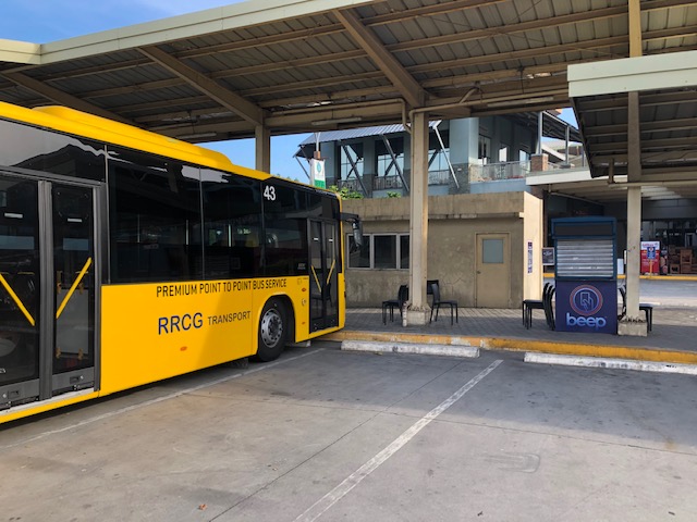 Idle P2P bus and closed booth – I usually took the P2P bus when I have meetings in the Ortigas CBD area. I usually alight at Medical City where its easy to get a ride (Grab) to my destination. If it was a meeting at ADB or somewhere near it, I just walk from Galeria.
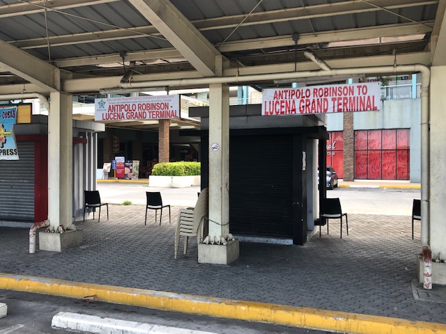 I didn’t know before that there were vehicles (likely vans) traveling between Antipolo and Lucena City in the Province of Quezon. Perhaps the route is via the Rizal “backdoor” (i.e., via the Rizal towns of Teresa, Morong, Tanay, Pililla, and then via Laguna through Mabitac, Siniloan, Pangil, Pakil, Paete, Lumban, Pagsanjan, and then Luisiana, Lucban and Tayabas in Quezon). This is typically a 3.5 to 4.5-hour trip depending on traffic conditions and the number of stops travelers make in between the ends.
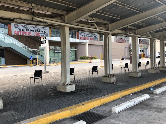 Antipolo-JRC is probably among the oldest jeepney lines connecting Antipolo with Metro Manila. JRC stands for what was Jose Rizal College. It is now Jose Rizal University or JRU but few jeepneys use JRU as most people are still familiar with JRC. I have fond memories of this jeepney line as I used to commute on these jeepneys when I was in high school. My school was located along Shaw Boulevard and I took the jeepney because it was the one that passed and stopped in front or just across from our school. Other jeepneys from Rizal turned at Capitolyo to go to the EDSA-Crossing terminal via the United Lab road. [Note: the chairs in the photo are not for the terminal but for customers who lined up for the supermarket. Note the distance between each chair.
–
Regular bus services for Antipolo
Finally, there is a regular bus service between Antipolo and Cubao. This will be between the Robinsons Antipolo transport terminal and the Araneta City (formerly Araneta Center) via Sumulong Highway, Marcos Highway and Aurora Boulevard. This is a more significant development than the P2P bus service between Antipolo and Ortigas CBD (i.e., Robinsons Antipolo and Robinsons Galeria) as this is a regular bus service with what appears to be designated stops. I say what appears to be designated stops based on the fare matrix released by the Land Transportation Franchising and Regulatory Board (LTFRB).
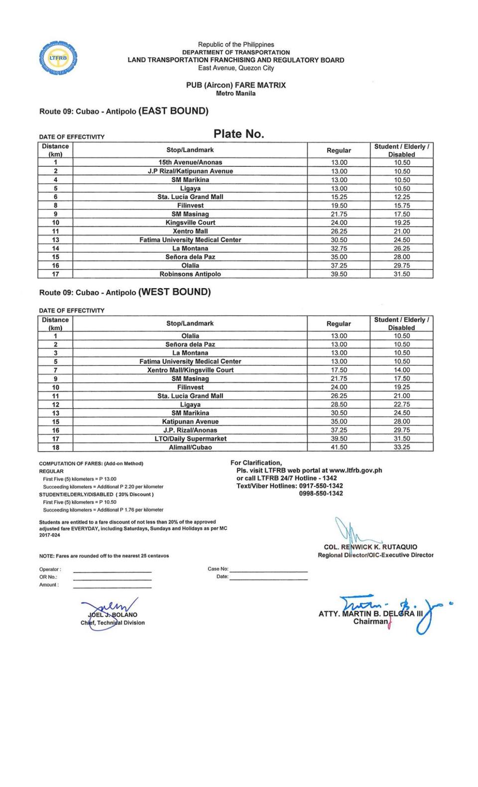
I have written about this in the past and communicated this to local and national officials and yetWill this spell the decline and eventually phasing out of the Antipolo-Cubao jeepneys? Probably not unless there is a strong move for a phaseout. The operation of the Line 2 Extension will surely impact them, too. But they can and should survive even for feeder services with respect to the rail and buses.
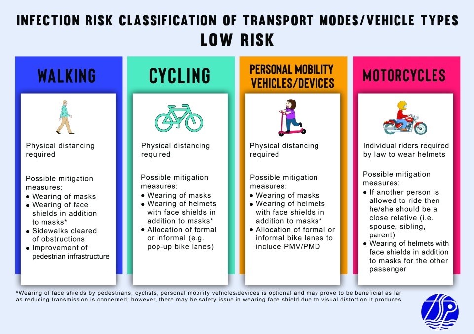
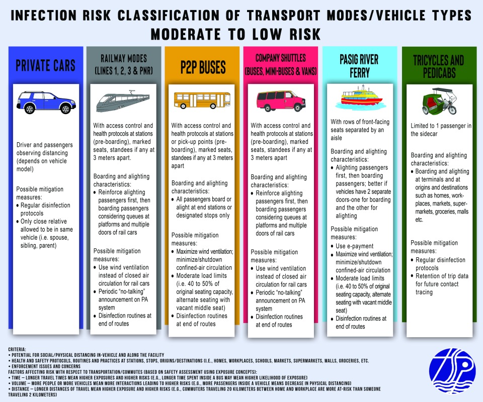
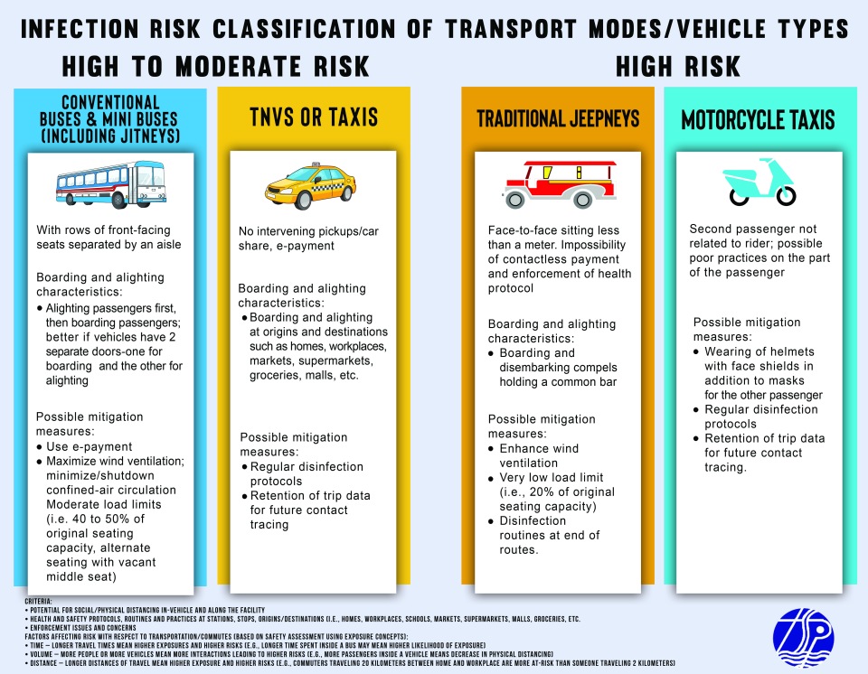
Infographics: Infection Risk Classification of Transport Modes Post-ECQ
The infection risk table I posted a few days ago was improved into the following infographics:
–
COVID-19 Infection Risk Assessment of Transport Modes
I posted about the work we have been doing to assess the infection risk (i.e., spread of COVID-19) for various modes of transport considering the transition of many areas including the National Capital Region (NCR) to the General Community Quarantine (GCQ). The work was undertaken through the Transportation Science Society of the Philippines (TSSP), which is under the umbrella of the Eastern Asia Society for Transportation Studies (EASTS). Here is the outcome in the form of an “Infection Risk Classification of Transport Modes or Vehicle Types” developed by a core group of public transportation and road safety specialists among its members:
![]()
![]()
![]()
![]()
Note again that this is the product of a rapid assessment using the mentioned criteria and factors. It is a qualitative assessment and a quantitative one, given the data, would obviously been preferred. Moreover, this is an assessment for risk of infection rather than for road safety. In the “old normal”, for example, cycling and motorcycle use may have a higher risk in traffic given traffic mix, human behavior and lack of facilities to make these modes safe.
–
Assessing the risk of infection from the transport safety perspective
My colleagues and I have been developing a risk assessment table for land transport modes to be submitted to the UP COVID-19 Response Team. We did a rapid assessment using mainly concepts from road safety.
The concepts are fairly simple. Risk assessment can be based on the likelihood of contracting the virus gauged from certain exposure factors. Exposure estimation may be quantitative where metrics are applied and data collected for the analysis. Estimation may alternatively qualitative based on experiences, perceptions, expert opinions, etc. but subject to logic (e.g., careful deduction). In road safety, for example, these factors may be defined as three: time, distance and volume.
Time exposure can be determined using travel time as a metric. Longer the travel times mean higher exposures for a commuter. Higher exposure translate to a higher likelihood that a person may become involved in a road crash. Thus, a commuter traveling for 1 hour, one way, will have a higher likelihood of being involved in a crash compared to another traveling only 10 minutes even assuming that both use the same mode of transport. Applied to the risk of viral infection, longer commutes may mean people can have higher exposure to potential carriers of the virus.
Distance exposure can be determined using travel distance as a metric. Longer travel distances mean higher exposures for a commuter. Higher exposure again translate to a higher likelihood that a person may become involved in a road crash. Thus, a commuter with a travel distance of 10 kilometers will have a higher likelihood of being involved in a crash compared to someone traveling only 1 kilometer. Applying this to the risk of viral infection is similar to the previous case for time exposure even when assuming the same mode of transport.
Volume exposure can be determined using both the volume of vehicles as well as the number of passengers inside the vehicles. The more vehicles or people you have on the roads interacting, the higher the likelihood of one becoming involved in a crash. It can also be argued that riding public transport in high volume, mixed traffic makes a passenger have a higher likelihood of being involved in a crash. Again, applying this to the risk of viral infection, it should be easy to understand why physical distancing is necessary in vehicles as well as outdoors when walking or cycling. It should also extend to having less vehicles on the road to further reduce the likelihood of spreading the virus.
In the real world, we cannot isolate each factor from one another. Instead, we have to contend with all three combining to create various scenarios. Along expressways, for example, the volume of vehicles might be high and so are distances. Time exposure can be lower due to high speeds. Yet high speeds can contribute to increased likelihood of crashes. Meanwhile, traffic congestion has all the ingredients for maximizing the likelihood for crashes and, by extension, viral infection. Long commutes (by time and distance) plus high volumes of people and vehicles combine to create the worst case scenario from the perspectives of both road safety and infection, which are both public health issues.
Next – Why we should not return to the old normal…
–
On the COVID-19 pandemic’s impacts on urban planning
Here is another timely article on the effects of COVID-19 on urban planning. Past pandemics have influenced the way cities are designed and COVID-19 is no different as we are now learning a lot of lessons on how towns and cities need to be laid out or structured to prevent future outbreaks from spreading so quickly while also allowing for a more effective actions in response to infections.
van den Berg, R. (2020) “How Will COVID-19 Affect Urban Planning?”, The City Fix, https://thecityfix.com/blog/will-covid-19-affect-urban-planning-rogier-van-den-berg/ [Last accessed: 5/15/2020]
–
