
On P2P bus services
We decided to take a Point-to-point (P2P) bus from Quezon City to the Ortigas Center to attend a meeting there. The venue was close to SM Megamall so we thought it best to just take the bus service from SM North EDSA. It was my first time to take a P2P bus but was familiar enough with the service from the research our students have been doing on public transport. Here are some photos from the experience.
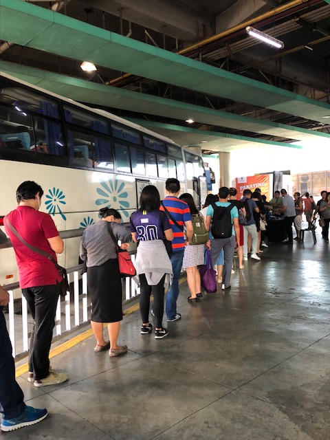 There’s a line for passengers riding the P2P bus from SM North to SM Megamall. It appears to be long but it moves pretty quickly because of the frequent bus arrivals that time in the morning (around 9:00 AM).
 The bus before ours was quickly filled with passengers. There is a “no standing” policy for this service so when all seats are taken, people in queue would have to wait for the next bus.
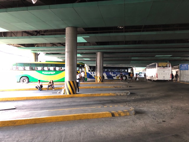 Here’s a view of the bus bays at SM North EDSA. The white bus at the right is the P2P bus that just departed.
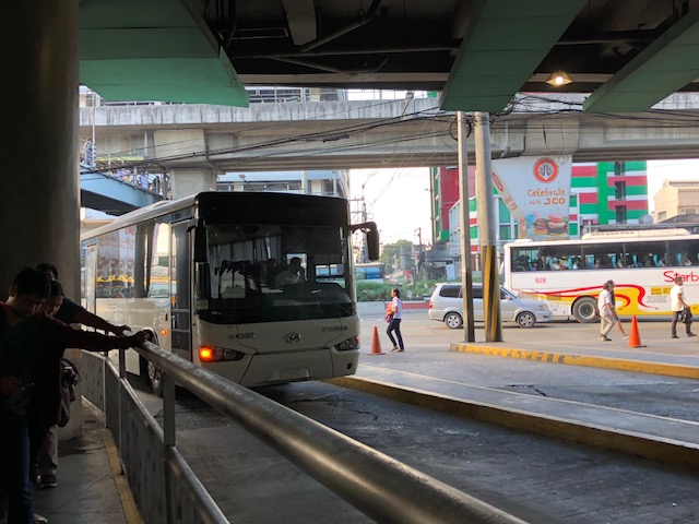 Our bus arrives at the terminal.
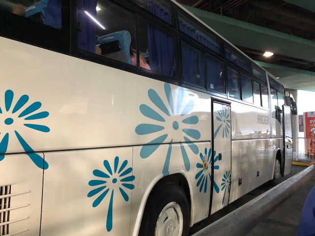
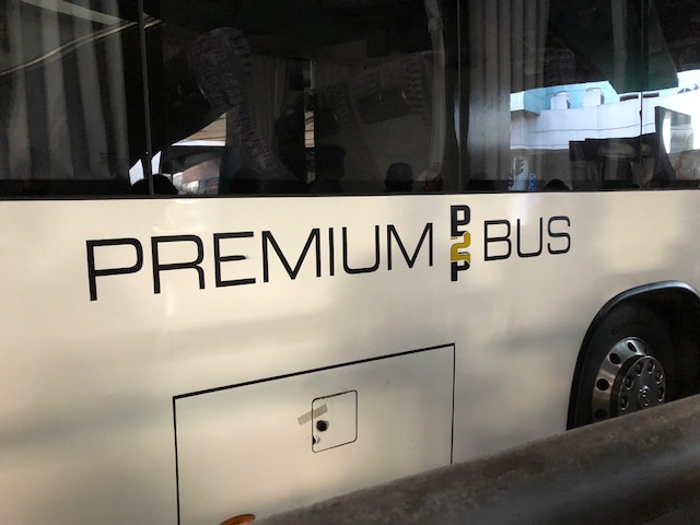 Unlike the first bus that had generic signs/markings on it and only had a signboard on the windshield identifying it as a P2P bus, this one had the service on its livery. The rapid increase in the number of P2P bus routes and buses serving those routes meant that bus companies had little time to properly change the livery of their buses to clearly show these were for P2P services.
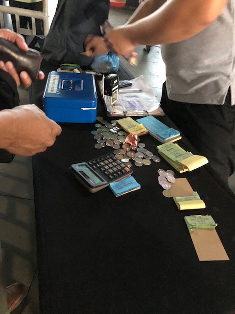 Passengers pay at the head of the line and just before boarding the bus.
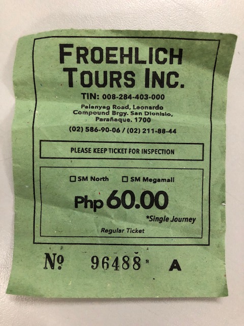 Our ticket showing the fare paid and the name and contact details of the operator of this service between SM North and SM Megamall. Froehlich is one of the first companies granted a permit to provide P2P services by the government. They actually started the service during the previous administration when DOTr was still DOTC.
The P2P bus services present an attractive option for commuters who are not satisfied with their usual public transport options (e.g., bus, jeepney or UV express) and cannot afford to frequently take taxis or ridesharing (Uber, Grab). They may or may not be car-owners but have longed for better public transport services especially in terms of comfort and convenience. Many are likely able to afford higher fares and will pay such if the services are worth it.
In Antipolo, for example, I have noticed that the parking lot near the P2P bus terminal at Robinsons already have many cars parked (parking is free so far), which I assumed are owned by people opting to take the bus instead to go to Ortigas Center. They have the jeepney and regular bus options (G-Liner and RRCG) but are turned off by the frequent stops and the cramped conditions during the rush hours.
My only other critique of the P2P buses aside from their drivers apparently being just the same as other buses in the way they drive (i.e., I’ve observed many of them are as aggressive if not as reckless as regular bus drivers.) is that these services are actually the higher capacity versions of UV Express. Note that UV Express (previously called Garage to Terminal Express or GT Express and generically the FX taxis of the 1990s) basically operated under the same conditions before with fixed routes and with supposedly only 2 stops (i.e., “point to point”). Hopefully, they won’t be but I also wonder how these services will continue once the new rail transit lines come into operation.
–
Updates on the MRT Line 7 construction
I recently posted some photos showing the progress of work on the Line 2 Extension. This time, I wanted to show photos on the progress of the Line 7 construction along Commonwealth Avenue. Following are some photos my companion took this morning as we headed for Novaliches. Work continues along this major corridor even on Sundays. While it has caused much congestions and therefore inconvenience, the continuous work offers hope to those who will benefit from this mass transit line once it becomes operational.
 Columns rise along Commonwealth Avenue just across from the Ever mall and St. Peter’s church.
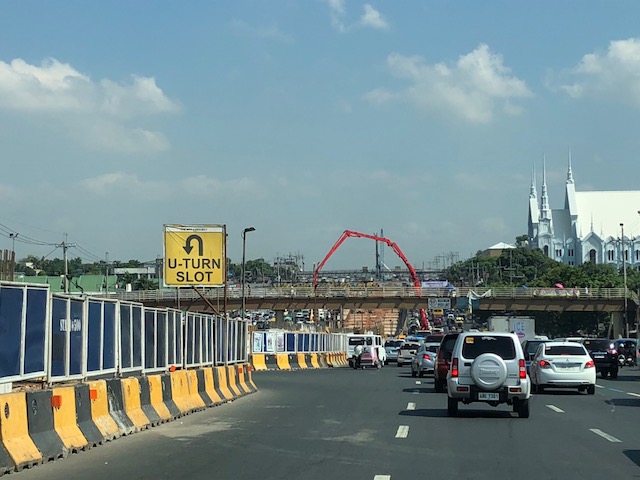 Here’s a traveler’s view of the ongoing construction along Commonwealth Avenue.
 Concreting even on Sundays – it was quite congested today near the Fairview Market due to lanes occupied by heavy equipment including several concrete mixers lined up along one lane to supply the mix.
I have several former students who are now working on the Line 7 construction in various capacities. I usually get my updates from them. I am happy for them to be involved in such a major infrastructure undertaking. Hopefully, their experiences will be useful for other future railway lines in the country.
–
In support of bike lanes
Here is another interesting article about bike lanes but from the perspective of a non-cyclist. I believe this (support for bike lanes) is a view shared by many but not much articulated. The assumption is usually that car-owners would like to have less of other’s cars on the road so they could benefit from the presumed reduction in congestion should more people take up cycling. But then the same can be said for public transportation and its users as well. That is, car-users would want others to take public transport so as to also reduce road congestion; allowing them faster trips/drives.
Lewyn, M. (2018) “A Non-Cyclist’s Case for Bike Lanes,” planetizen.com, https://www.planetizen.com/node/97632?utm_source=newswire&utm_medium=email&utm_campaign=news-03152018&mc_cid=0e22636014&mc_eid=9ccfe464b1 [Last accessed: 3/17/2018]
–
Some updates on the Line 2 Extension
I just wanted to post a couple of photos showing the progress of the Line 2 Extension construction work. There are two stations along the extension including the future end station before the Masinag Junction (intersection of Marcos Highway and Sumulong Highway).
 Ongoing construction of the Line 2 Masinag Station just across from SM City Masinag in Antipolo City, Rizal – there are actually 3 usable lanes with only the middle being a full lane, the other two have concrete barriers encroaching along the site as shown in the photo.
 Ongoing construction of the Emerald Station across from both the Sta. Lucia and Robinsons Metro East malls at the boundaries of Pasig City, Marikina City and Cainta – the construction site here is longer than the one for Masinag but has wider spaces for traffic. Volumes, however, are significantly heavier than at Masinag so this area can easily become congested with traffic often stretching past the PLDT office along the westbound side and Ligaya along the eastbound side.
I will post more about the progress of construction for these stations in the future especially as it would be interesting to see the actual forms of the stations.
–
Lazarus franchises?
I was recently asked about my views on Lazarus franchises. At first the term didn’t catch on to me but “Lazarus” is a name that’s associated with coming back from the dead. “Lazarus”, after all, is the Biblical person Brought back to life by Jesus after the latter arrived to find his dear friend had passed away due to illness. It is now being used to refer to a dead public transport franchise that is to be resurrected but under new ownership. I recall I have written about the topic some time ago (many years ago) when I spotted what I thought was a BLTB Co. bus that turned out to be a DLTB Co. Bus. The logo and livery for their buses were the same as are the destinations in Southern Luzon. Then there were the EMBC buses I spotted along my commute that turned out to be operated by RRCG. These obviously are revived franchises and in both cases take advantage of what name recall the brands still have.
 DLTB Co. used to be BLTB Co., which stood for Batangas, Laguna, Tayabas Bus Co. Tayabas is the old name of Quezon Province. This is the current company’s terminal along EDSA in Cubao. The old terminal is also along EDSA near Tramo in Pasay City.
I opined “that brands associated with these franchises can be revived but there are prerequisites. These include an inventory of units currently operating in relation to the demand. The rule is to determine first if existing operators/companies can cover the increasing demand. If not, then the LTFRB may decide to open routes for new players including issuance of new franchises. “New” here probably includes “resurrected” franchises that have name recall among people.” To be clear, there is a process by which franchises are granted by the government and this should be followed in order to be fair with current, active franchise holders.
I wonder if the Antipolo Bus franchise can be revived to serve the old Antipolo – Divisoria route?
–
On child-friendly cities
Here’s another article that I want to share. This time it is about child-friendly cities. Here is an article that present many good practice examples in other cities. Many are easily replicable in our towns and cities, and should be considered by local governments in order to enhance safety and health aspects in their jurisdictions.
Laker, L. (2018) “What would the ultimate child-friendly city look like?”, theguardian.com, https://www.theguardian.com/cities/2018/feb/28/child-friendly-city-indoors-playing-healthy-sociable-outdoors [Last accessed 3/9/2018]
–
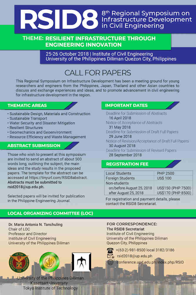
8th Regional Symposium on Infrastructure Development (RSID)
I would like to promote a symposium that our Institute of Civil Engineering (ICE) at the University of the Philippines Diliman will be hosting this year.
The Institute of Civil Engineering, University of the Philippines Diliman together with Kasetsart University (Thailand) and Tokyo Institute of Technology (Japan) is pleased to invite you to participate in the:
8th Regional Symposium on Infrastructure Development
in Civil Engineering (RSID8)
Theme: Resilient Infrastructure Through Engineering Innovation
Date & Venue: October 25-26, 2018 Institute of Civil Engineering,
University of the Philippines Diliman, Quezon City Philippines
Abstract Submission:
Those who wish to present in this symposium are invited to submit and abstract of about 500 words under the following themes:
Sustainable Design, Materials and Construction
Sustainable Transport
Water Security and Disaster Mitigation
Resilient Strudtures
Geomechanics and Geoenvironment
Resource Efficiency and Waste Management
Deadline for Abstract Submission: April 16, 2018
Template: tinyurl.com/RSID8abstract
Please see attached poster of call for papers for more details.
Kindly disseminate to your colleagues who may be interested.
For more information of the conference please contact:
Christian R. Orozco
RSID8 Secretariat
Institute of Civil Engineering
University of the Philippines Diliman
Email: rsid2018@up.edu.ph
Website: conference.upd.edu.ph/index.php/RSID
–
On the Pasig HOV lane experiment, again
I recently wrote about some thoughts on Pasig City’s HOV lane experiment along Julia Vargas Avenue. Here are a few more considering the experiment didn’t push through last February 28.
 Screen cap (courtesy of ABS CBN) showing the starting date for the HOV lane experiment. I think ‘HOV’ is more appropriate than ‘carpool’ since the requirement is for vehicles using the lane to have 4 or more passengers. Having only 2 passengers still qualify as a carpool.
I learned recently that the experiment has been put off to March 26, 2018:
 [Photo courtesy of Dulce Justiniani]
The current set-up has 2 lanes for motorised vehicles including a wide lane for HOV’s (including public utility vehicles like buses and vans). HOV’s here also include cars but those with at least 4 occupants. Here are a couple of photos showing us what could possibly happen should enforcement be weak given the configuration of the lanes along Julia Vargas:
 Private van running along the lane designated for HOV’s alongside a solitary cyclist on the bike lane.
 An SUV overtaking the van via the bike lane and the extra space of the HOV lane.
Wide lanes generally encourage higher speeds. I believe the way to go would be to have narrower lanes. And should these be considered, it would be possible to have 3 lanes for motorised traffic with one assigned for HOV’s and another for motorcycles. These are aside from the bicycle lane that I think should also be a protected lane. Protection here may be through the provision of “forgiving” physical dividers in the form of, say, rubber bollards.
Here’s how the Julia Vargas carriageway could be laid out:

Again, these are just suggestions for whoever are in-charge of the experiment-to-be along Julia Vargas Avenue. I hope that they are able to make some assessments even prior to the experiment. Such can be done using simulation software in order to have a handle on traffic related issues that may crop up during the implementation. Still, a big factor would be the enforcement aspects of the proposed policy for motor vehicles. Strict, firm and sustained enforcement would be necessary in order for this to succeed.
–
On prioritising pedestrians and promoting walking
We begin March with an excellent article that came out from curbed.com:
Walker, A. (2018) The case against sidewalks and how cities can create new avenues for pedestrians, curbed.com, https://www.curbed.com/2018/2/7/16980682/city-sidewalk-repair-future-walking-neighborhood [Last accessed 2/23/2018].
How do we improve the environment (i.e., facilities) to encourage people to walk? Do we simply clear up sidewalks? Widen them? Build overpasses and underpasses? What should be the context for improving pedestrian facilities for our cities and municipalities? What are the implications to planning and design?
–
Another walkability tool: Pedestrians First
The ITDP recently came out with a new walkability tool called Pedestrians First. Here’s the link to their site where you can download the tool. The tool was released in the recently concluded World Urban Forum held in Malaysia.
https://www.itdp.org/publication/walkability-tool/
Of course, there are other tools out there including one developed by Clean Air Asia, material on which may be found through the following links:
http://cleanairasia.org/walkability-study-in-asian-cities-4/
Our technical staff and my students are currently using the methodology developed by Clean Air Asia and have covered several major thoroughfares in Metro Manila and a highly urbanized city in studies that have been undertaken in the last 6 years. I already asked them to take a look at the new tool and see how this compares with the ones we are using.
–
