
Home » Cycling (Page 18)
Category Archives: Cycling
All weather transport
The flooding brought about by heavy rains around the country rendered many roads impassable to motor vehicles. This meant traffic congestion in many areas and so many commuters being stranded due to the lack of public transport vehicles available to them. In these times, the only modes for traveling are reduced and limited to walking and non-motorized tranport (NMT). While cycling is an option for some people, a more popular mode in many areas and local roads are pedicabs. Known by various names in the vernacular such as padyak, trisikad, sikad, etc., these three wheelers are found providing transport services particularly in residential areas. These tend to use national roads and busy streets in cities, and such often causes conflicts with motor vehicles as the NMTs slow down traffic. During times of heavy rains due to typhoons or the monsoon, pedicabs become the mode of choice for many who need to get to their workplaces, schools or home despite flooded streets.
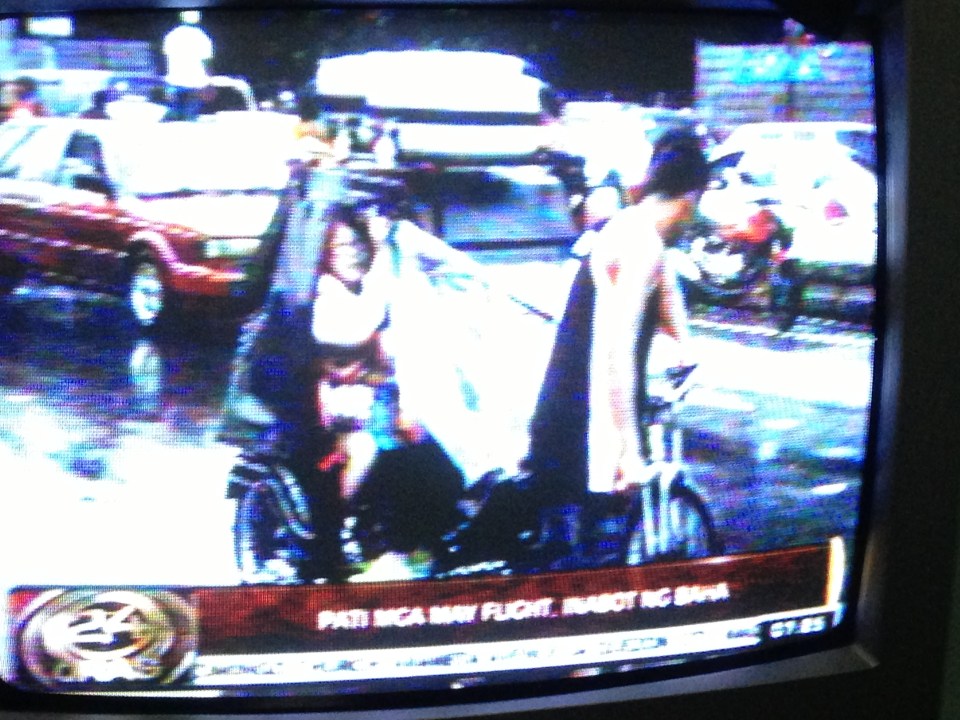 Photo of TV news report (GMA News’ 24 Oras) on air passengers taking pedicabs in order to get to the airport and catch their flights. Traffic was terrible due to floods along airport roads and only the non-motorized transport could navigate the flood waters. Interviews of passengers including tourists and foreigners showed their appreciation of the alternative mode of transport they had to take to catch their flights.
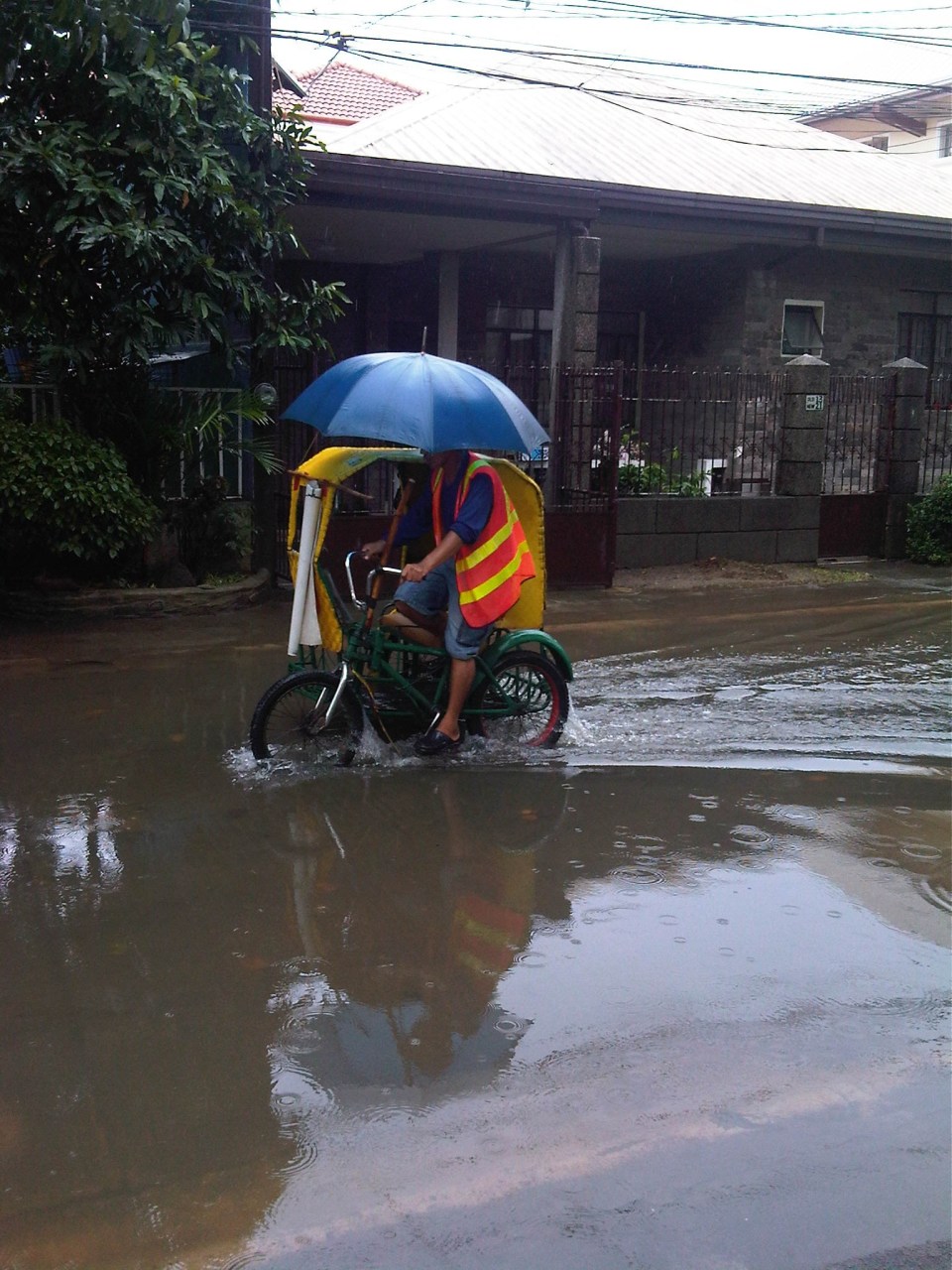 Pedicab service along a flooded residential road – special rates are often charged by pedicab drivers during the rainy season and when go into flooded streets. Regulated fares are charged in areas like residential subdivisions where homeowners associations have a say in fare rates. In other places, fares can be arbitrary or according to the willingness to pay of prospective passengers.
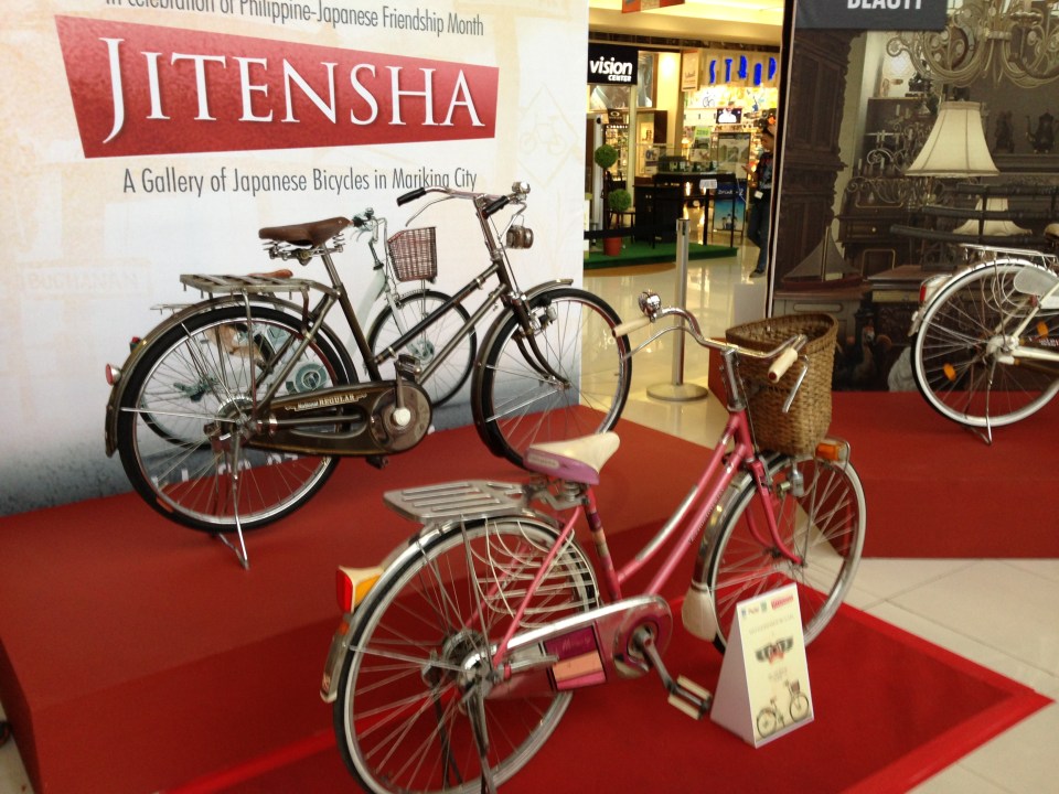 Bicycles are becoming popular for commuting not especially due to floods but more because of increasing fuel prices and fares. There is also an influx of second-hand or used bicycles from Japan (Note: Jitensha is bicycle in Japanese). These have become collectibles but are in actual use by their owners like the bikes shown in the photo that were exhibited at a mall recently.
–
More bikeways please!
After the construction of a bikeways network in Marikina City, the city became a poster child for sustainable transport in the Philippines. The bikeways was initiated with assistance from the World Bank for the pilot route and was later expanded by the city under the leadership of its Mayors, the former MMDA Chair Bayani Fernando and his wife Marides Fernando. The bikeways were promoted as a good practice example for non-motorized transport (NMT), with the National Center for Transportation Studies (NCTS) of the University of the Philippines Diliman involving the Marikina City Bikeways Office (MCBO) in its studies and advocacy work on Environmentally Sustainable Transport (EST).
 Bikeways between pedestrian walkway (red pavement) and parking slots in Marikina City.
 Bike lane along the Academic Oval at UP Diliman in Quezon City.
 Bike lane integrated into the sidewalks along Marcos Highway in the cities of Marikina, Pasig and Antipolo.
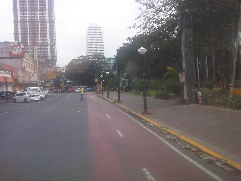
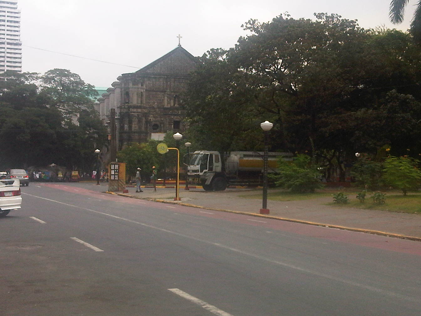 Bike lanes (red pavement) in Malate, Manila.
 Bike lanes integrated with the sidewalks along Commonwealth Avenue in Quezon City.
 Bike lanes integrated with the sidewalks along Commonwealth Avenue in Quezon City.
This is obviously not a comprehensive list of bike lanes and bike ways in the Philippines. I am sure there are similar projects in other cities and I am aware that cycling is becoming more popular around the country. These are but examples of what has been accomplished so far and it is clear that we need to do more to promote cycling not just as a sport or for recreation but, more importantly, as a means for commuting. Integrating cycling into one’s daily routine is a healthy and money-saving option, and segregated bikeways and bike lanes ensure the safe travels for cyclists. This, of course, is in consideration of the little respect cyclists (and pedestrians) get from motorists who believe road space is theirs alone.
–
More pedestrian facilities please!
I took a couple of photos one late afternoon on a weekday on my way home. I wanted to have a picture of typical jeepney overloading during the afternoon peak. Typically, jeepneys would allow “sabit” or passengers hanging from behind the jeepney. This practice is actually prohibited and carries a fine if jeepney drivers are apprehended. And that is usually a big “if” considering enforcers turn a blind eye to the practice especially during peak periods when it is difficult to get a ride.
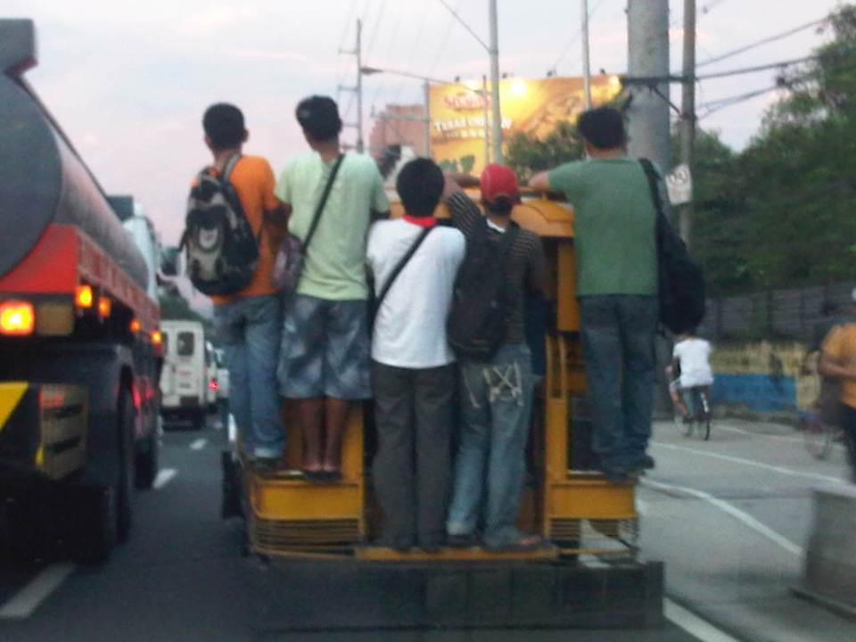 Jeepney full of sabit or hangers-on in heavy traffic along the eastbound side of a major highway
I also happened upon an opportunity to take a photo of the overloaded jeepney together with pedestrians walking along the walkway at the roadside. Though the photo was not so clear, it captured the image I wanted with people opting to walk while others took a risky ride on a jeepney. The cyclists in the photos were just bonuses and added to the visual of alternatives for mobility.
 Pedestrians and a cyclist along the widened walkway/bikeway along Marcos Highway
Walking remains as the mode of transport with the highest share when all modes, motorized or non-motorized, are compared. While there is a strong clamor from cyclists for bikeways and for cycling to be taken up by more people as an option for commuting, the reality is that cycling is not really for everyone. It is a viable and healthy mode but should also fit in a hierarchy of modes. Most people walk and walking should be encouraged over distances where it is most suitable. Facilities for walking need to be provided and properly designed so that people can walk safely and most efficiently like the example in the following photo taken during another weekday late afternoon.
 People walking along Marcos Highway
Local governments help promote walking by making sure sidewalks are provided and clear of obstructions. Perhaps walkability can be used as an indicator or parameter for a city to be qualified as livable and true to the advocacy of sustainable transport. Walking should be encouraged to promote healthy living as it incorporates exercise in our daily routines. More people walking should also increase awareness for the advocacy for clean air and help initiatives to improve air quality, particularly efforts to reduce harmful emissions by motorized vehicles. Thus, it is not difficult to understand how investing in pedestrian facilities and promoting walking is not a smart move and a beneficial one for any politician’s constituency.
–
Swapang! or the perils of walking
Walking to the jeepney terminal for a ride to the university, I was irritated by the constant honking behind me as motorcycles rode up the sidewalk to avoid the weaving into congested traffic along Aurora Boulevard. And so I tried to stand my ground allowing only half the space of the sidewalk for these motorcycles to pass through. As far as I’m concerned, I was already too generous giving part of the space that is for pedestrians and not for motorized traffic. Still, there were a few motorcyclists who seem to think they had the right of way as they attempted to convince me give up more space so they could practically take over the sidewalk. I didn’t give way and assumed they were cursing me inside their helmets. Manigas sila! I thought that in the end, sila ang asar at talo in this situation, not me.
 Motorcycles dominating space for pedestrians
At one point, I held my ground and didn’t give way to the motorcycles behind me [Advisory: This is not for everyone especially those who are “pikon” or who are looking for a fight.]. I knew my rights and I was walking on the pedestrian sidewalk. Unfortunately, a bicycle came along and I gave way only because I also appreciated cycling and understood that pedestrians and cyclists are sort of “kindred spirits” in a world dominated by motorized transport. The bicycle was immediately followed by two motorcycles including one that almost sideswiped the cyclist. I took the photo above to better show the situation.
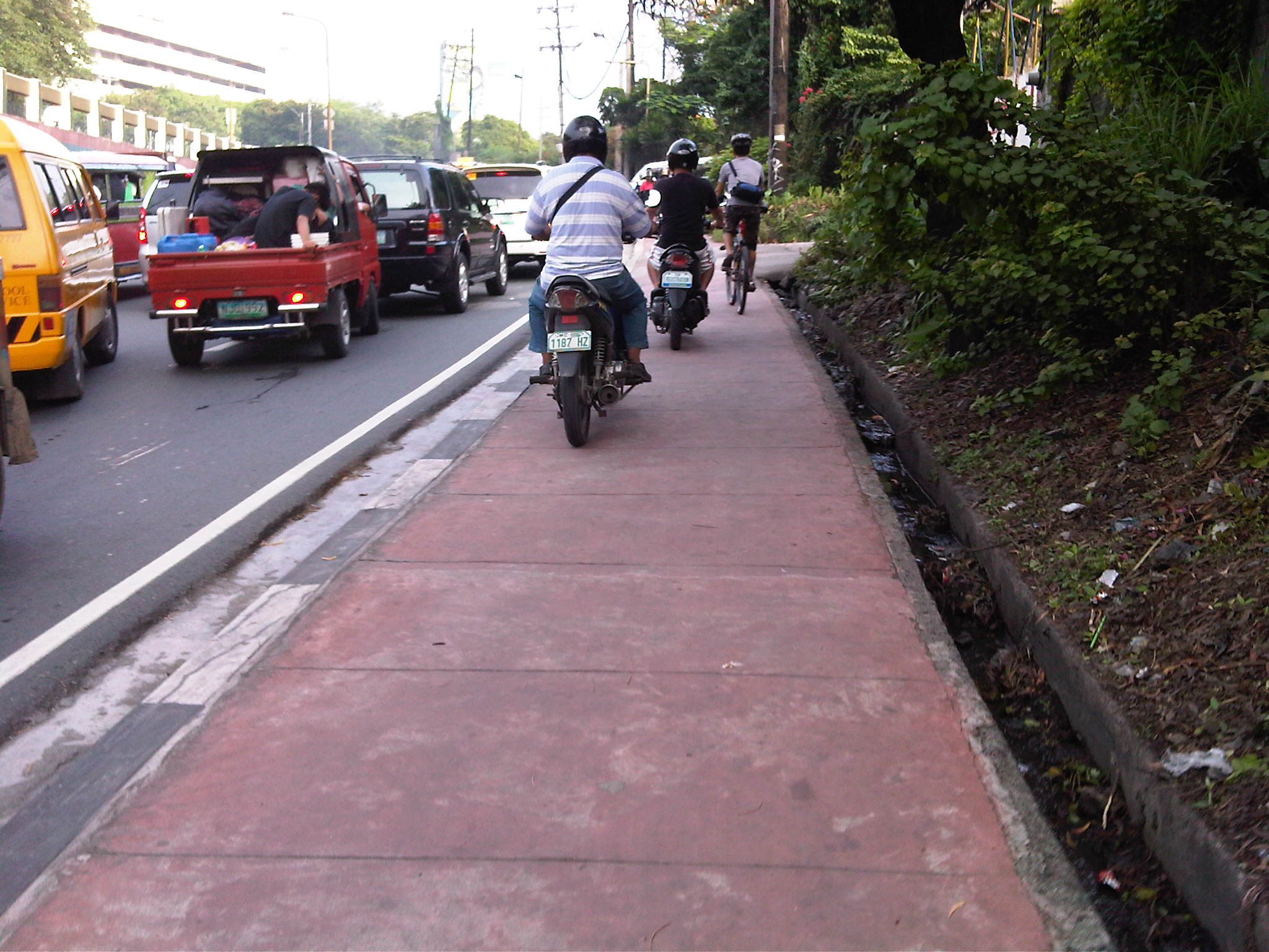
The other day, I chanced upon a similar situation as I was driving in heavy traffic along Amang Rodriguez in Pasig City. What little space was available for pedestrians along a narrow sidewalk along this road connecting Marikina and Pasig cities.
 Motorcycles using a narrow pedestrian sidewalk to avoid traffic congestion along Amang Rodriguez
These cases are clear examples of swapang attitude or behavior that is prevalent among many road users. Unfortunately, these are not apprehended or accosted by traffic enforcers. The latter seem to be more engrossed with number coding and swerving violations, anyway, that they seem to have forgotten all the other traffic violations that included this brazen behavior of motorcyclists. Perhaps enforcers should go back to the basics and take more notice of all those other violations (e.g., speeding, counter flowing, beating the red light, beating the green light, etc.) to improve and promote discipline on our roads.
–
More quick wins for cycling
Metro Manila is basically not a cycling-friendly metropolis. Road space is practically devoted to motor vehicles and sidewalks are not wide enough to accommodate a lane for cycling or space that can be shared by pedestrians and cyclists. The latter observation on space is actually arguable considering that in Japan, narrow sidewalks and carriageways are usable for cyclists and people are generally respectful of others’ right-of-way and perhaps right to travel. As such, conflicts are minimized among pedestrian, cyclists and motorists.Such situations can also be achieved in Metro Manila and other Philippine cities as well. Key is to have a consciousness among people of everyone’s right to space. Also, there is a need to actively, persistently promote a safe interaction among road users such as what has been done by cycling advocates like the Firefly Brigade and what the MMDA is now doing with their initiatives promoting NMT.
Searching for some quick wins aside from the example of Marikina (where there are formal bikeways already in place), I’m featuring a few photos taken around Metro Manila that can be regarded as examples where there have been initiatives toward quick wins in promoting cycling. These include a couple of photos in the Malate, Manila area and couple along Marcos Highway in Pasig City.
 Bikeways in Malate
The Malate Church
 Segregated bicycle lane along Marcos Highway
 Cyclists along Katipunan Avenue (C-5)
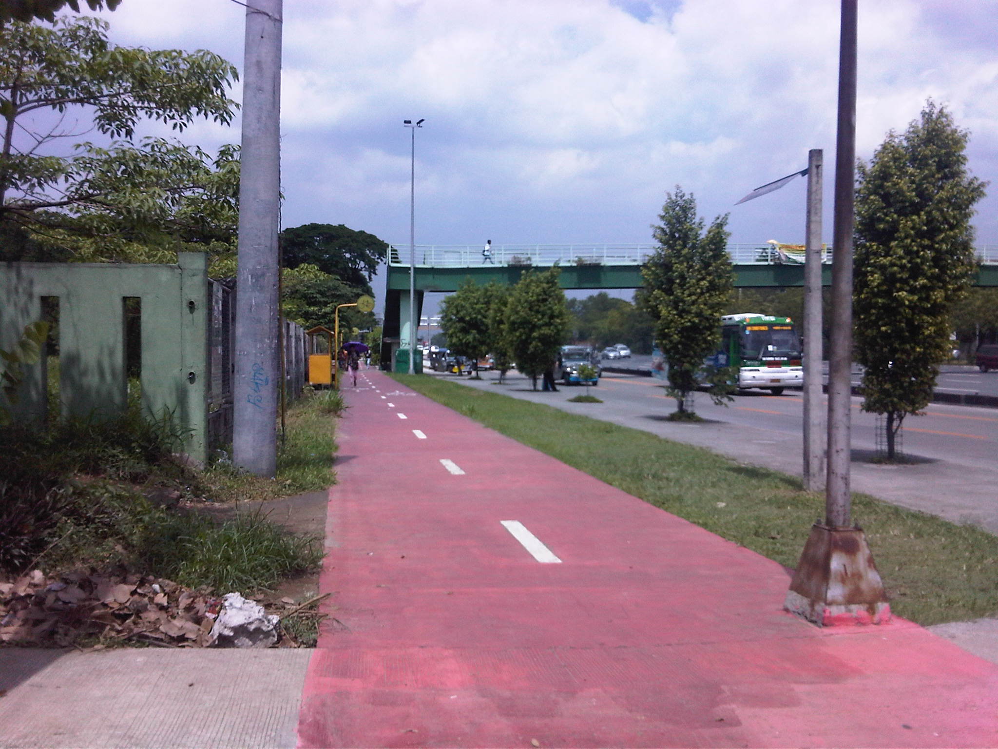
 Segregated bikeway and overpass ramp along Marcos Highway
Except for the case of Katipunan, all the photos show space designated for cyclists. But Katipunan should be seen as a corridor that has a high potential for walking and cycling given the nature of the land use between Ateneo and UP Diliman. There are opportunities here to promote suitable non-motorized modes of transport while also working for a reduction in car use associated with the schools in the area. While there are still issues of encroachments (e.g., vehicles parked on the sidewalk, and depriving pedestrians and cyclists of their space) in the case of Marcos Highway, these are enforcement issues that LGUs like Antipolo City should address. I cite Antipolo because Marikina and Pasig are generally for cycling and have often reminded establishments to clear the space for pedestrians and cyclists.
–
“Make it easy!” – Encouraging cycling in the Philippines
The stretch between Magallanes and Ayala Ave. along EDSA is not exactly the most ideal of sections for a bicycle sharing program. However, its success would be symbolic of a small and quick win for cycling in a metropolitan area that’s been perceived to be unfriendly to walking and cycling. The Metropolitan Manila Development Authority (MMDA) could have chosen other sections like a longer one along Commonwealth Avenue or perhaps a section of Circumferential Road 5 (C-5)/Katipunan Avenue like the stretch from Aurora Boulevard to C.P. Garcia Ave. that connects three major academic institutions: Ateneo De Manila University, Miriam College and the University of the Philippines Diliman. Marcos Highway, which stretches from Masinag Junction in Antipolo City to Santolan in Pasig/Marikina, was rehabilitated and now has exclusive bicycle lanes along either side of the highway. And, of course, there is the bicycle network in Marikina City, which is the first city in the country to have bikeways.
A friend posted an article about “The Best Bike-Sharing Program in the United States.” It is a good read with lots of lessons for cities formulating their own bicycle-sharing programs. Such programs are made in part to encourage a shift from motorized transport to non-motorized modes like cycling and walking. With motorcycles becoming more popular in the Philippines, there should be strong efforts to promote bicycle use especially for short trips.
 Cyclists pedaling along UP Diliman’s Academic Oval where one lane has been designated for NMT.
Another perspective on promoting/encouraging cycling comes from Europe. I read an article that caught my fancy sometime last year and searched for it on the internet. The article appeared on the online version of the New York Times stating as its title: “To encourage biking, cities lose the helmets.” This is an interesting article because, for one, the author relates experiences in Europe that seem to be in contrast with those in the US. Particular mention is given to cyclists being required to wear helmets in US cities while many European cities are lax about this practice that is strongly associated with road safety.
There I said it. Road safety. A primary concern for many if not most road users including those using bicycles is safety. In the cities where cyclists share road space with motor vehicles, crashes involving NMT and motorized vehicles may result in fatalities. Studies in the US have linked fatalities and serious injuries to cyclists not wearing helmets. However, in European cities where there are more cyclists and drivers of motor vehicles are probably more aware and respectful of cyclists, the perception is that laxity in helmet use helps promote cycling.
In the Philippines, where mandatory helmet use for motorcyclists is a continuing enforcement challenge, strictly requiring helmet use for cyclists can also be a challenge and can be a turn-off for many would-be cyclists. Strict helmet-wearing requirements might be equated to cycling being a dangerous activity and therefore discourage a lot of people from using bicycles. Definitely, safety should not be sacrificed and where there are high risks but these sections need to be identified and enforcement along these should be firm. These include routes where bicycles and motor vehicles share the same road space. In routes, however, where there are exclusive space or lanes for cycling, perhaps the rule on helmets may be relaxed. Speed is one consideration here where those using bicycles for trips between their homes and workplaces or schools are not necessarily speedsters compared to those who cycle for recreation or for sport. Utilitarian cycling should be treated differently from recreational or sport cycling, which can be more risky and requires not only helmets but other safety gear as well.
–
Transport gaps
I first learned about the concept back in the 1990’s when I was a graduate student at UP majoring in transportation engineering. The concept on transport gaps was first mentioned in a lecture by a visiting Japanese professor as he was discussing about transport modes, particularly on which was suitable or preferable over certain travel distances and which could carry more passengers. Another time later and while in Japan, I heard about the concept during a presentation of a friend of his technical paper on public transport.
The figure below is one of many possible illustrations of the concept of transport gaps. In the figure, a distinction is made for mass transport and individual transport. As the original figure is likely taken from a textbook or a paper (probably from Japan), shown with a white background are the more conventional modes of transport including subways, urban and suburban railways, walking and a mention of the shinkansen (more popularly known as the bullet train). With a gray background in the original figure is a category on new urban transit systems that include monorails, AGTs and LRTs. If we attempt to qualify local transport modes such as jeepneys, UV Express, tricycles and pedicabs into the graph, the outcome can be like what is illustrated with different color backgrounds in the figure below.

The concept of transport gaps allow us to visualize which modes are suitable for certain conditions where other established modes of transport may not be available or viable. In the original figure, the gap in Japan is filled by new urban transit systems. In our case, gaps are filled by so-called indigenous transport modes such as jeepneys, multicabs, tricycles, pedicabs and even habal-habal (motorcycle taxis).
There are gaps in the Philippine case probably and partly because of the slow development of public transport systems such as the mass transport modes shown in the preceding figure. There was a significant gap right after World War 2 when the tranvia and other railways were destroyed during the war. That gap was filled by the jeepney. There was also a gap in the early 1990’s that was eventually filled by FX taxis. Such gaps can obviously be filled by more efficient modes of transport but intervention by regulating agencies would be required and rationalizing transport services can only be addressed with the provision of mass transport options complemented by facilities for walking and cycling that will complement these modes.
–
Eastbound walk along Marcos Highway
I took a couple of photos of the walkway and bikeway along the eastbound side of Marcos Highway while traveling to Antipolo one weekend. This used to be a wide, open canal along the eastbound side of the highway, which forced pedestrians and cyclists to use the outermost lane of the carriageway. Such exposed people to a high risk of being sideswiped by motor vehicles that often speed along the sections shown in the following photos.
 Sign indicating bicycle path along the eastbound side of Marcos Highway. The space is supposed to be shared with pedestrians. Concrete barriers are supposed to provide protection from wayward vehicles.
 Treatment at driveways of establishments along Marcos Highway. Notice the white line delineating space for pedestrians and cyclists. The overpass at Dela Paz can be seen downstream in the photo. The overpass has a ramp for cyclists and persons with disabilities.
The pedestrian and cycle paths along both sides of Marcos Highway greatly enhance the safety features of the highway. These will especially be important come summer, particularly during the month of May, when many people take the Marcos Highway route to Antipolo Church in what is one of the most popular (if not the top) pilgrimages in the Philippines.
–
Marcos Highway Bikeways and Walkways
I have written about the need for pedestrian facilities in previous posts. These include walking as a mode of transport, walkability in the Philippines, and even some personal experiences. There is no doubt about how important pedestrian and bicycle facilities are in order to promote walking and cycling as environment-friendly, healthy, and therefore sustainable modes of transport. Cities and towns where people walk and cycle are among the most healthy and perhaps vibrant places in the world. Walking outdoors, in fact, should be promoted if not encouraged (i.e., its difficult to encourage if there are no facilities, and health and safety are concerns) in cities where tourism is also being promoted as it can be used as an indicator for how easy it is to go around the city or town and perhaps how clean the air is in the area.
Following are a few photos I managed to take along Marcos Highway that show the newly designated bikeways apportioned from the sidewalk that was constructed along with the rehabilitated carriageway. There are bikeways on both sides of the highway as what used to be the open channel drainage was replaced by culverts and the sidewalks where built on top. In order to enhance the safety of pedestrians and cyclists, concrete barriers were placed along the road margins just above the curbs. The barriers actually work in another way, preventing or discouraging pedestrians or cyclists from wandering into the traffic lanes of this busy thoroughfare.
 The white line delineates the bikeway, which is the lane along the curb, from the pedestrian walkway that is on the inner side of the path. This can be a bit confusing and creates conflicts between pedestrians and cyclists as the parts of the roadside are also designated as bus/jeepney stops.
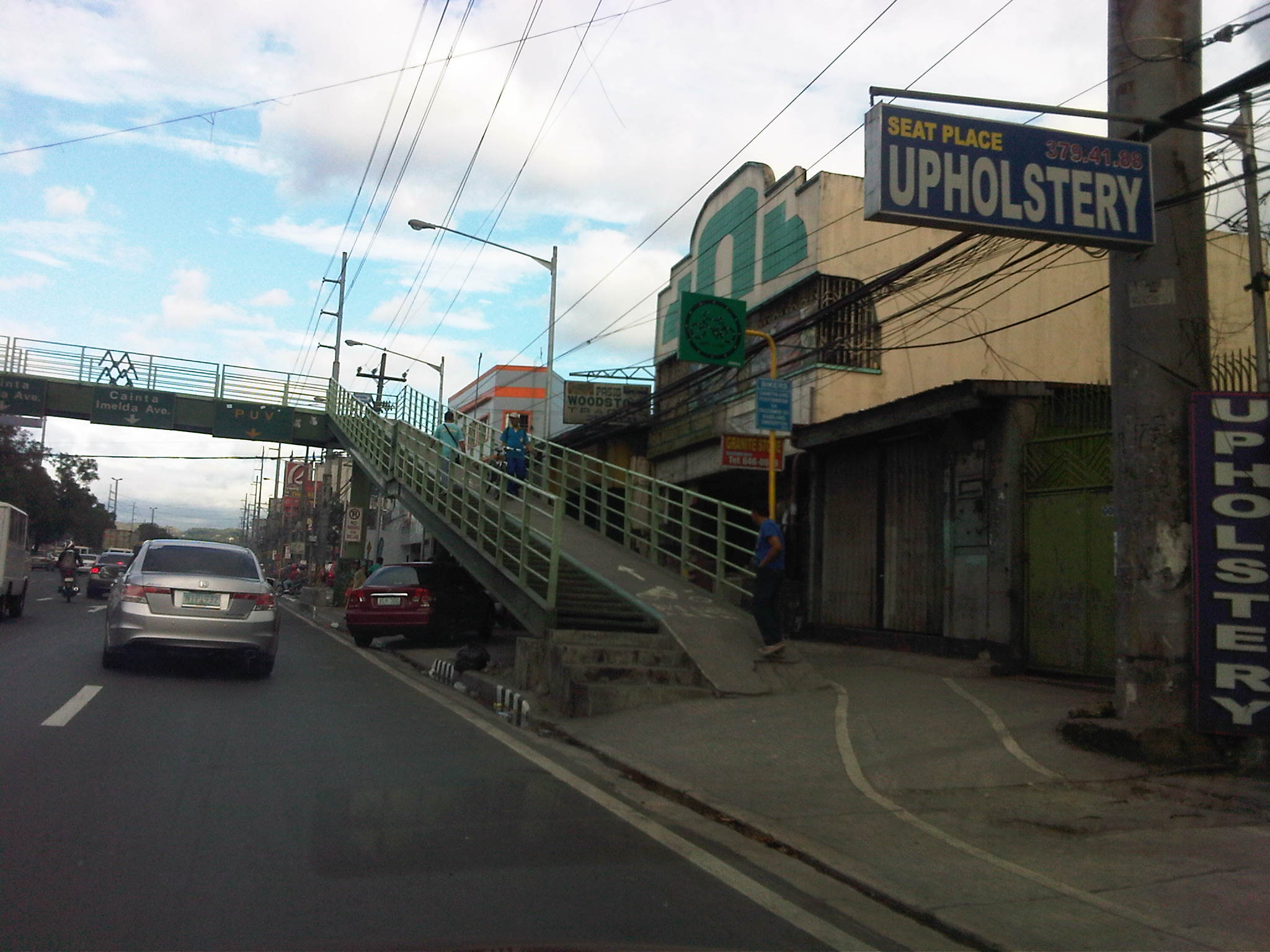
 Obstructions? – the bikelane runs smack into the staircase of the pedestrian overpass while the pedestrian path leads to electric posts. Such are issues that are also present along the more established bikeways of Marikina City.
 Too many signs? – from this view, there seems to be a lot of signs along the bikeway, appropriate perhaps in order to inform motorists, pedestrians and cyclists about the facilities. The signs are also useful for enforcement as Marikina City, for example, is strictly enforcing its policies against parking and other obstructions along the bikeway. Unfortunately, Pasig, Cainta and Antipolo are lax in their responsibilities to clear the bike and pedestrian paths from obstructions.
 Which direction? – the bike path markings state the direction for flow. Such is at best a suggestion as it is quite difficult to enforce one way flow for cycling. It must be made clear that the bikeway is mainly for commuting or utilitarian rather than for recreational or sporting purposes. Speeds should be slow enough for cyclists and pedestrians to co-exist and perhaps share space for two-way flow.
 All clear – the bike path is good enough even despite it going along so many driveways due to the nature of the developments along Marcos Highway. The bike path in front of the Metro East mall can be filled with commuters waiting to catch a ride and won’t be passable to cyclists especially during the afternoon to evening.
 Unfortunately, crossing the highway is another challenge for cyclists as the steps for most overpasses along Marcos Highway are quite steep. There are at least 3 that were designed to have ramps (the Imelda Ave/A. Tuazon, Dela Paz and Ligaya overpasses have ramps) for bicycles and wheelchair access).
 Establishments along highway can pitch in by ensuring the bike and pedestrian paths are clear of obstructions including parked vehicles. Incidentally, there is one gas station along Marcos Highway that is also a depot for taxis where the latter seem to always occupy the sidewalks. I have seen Marikina staff flagging them for disrespecting the right of way of pedestrians and cyclists but they seem to have some difficulty in clearing the area of parked vehicles. (Note: The Dela Paz pedestrian overpass is visible downstream.)
The pedestrian and bicycle facilities along Marcos Highway will certainly go a long way in promoting walking and cycling. At both ends of the highway though, at the Masinag junction at the eastern end and Santolan in the west, there are issues pertaining to continuity as both bikeways and walkaways disappear and pedestrians and cyclist would suddenly have to contend with mixing it up with motor vehicles along the carriageway should they want to continue in their travel. This issue of continuity should be addressed both by policy and the provision of suitable facilities for cycling and walking.
Perhaps something to think about is the realization of a link between the Marikina Bikeways, the Marcos Highway bike paths and UP Diliman’s bicycle lane along its academic oval via Aurora Boulevard and Katipunan. This can eventually be linked to the wide sidewalks along Commonwealth Avenue that can also be apportioned for pedestrians and cyclists. Perhaps such an integrated network covering parts of Quezon City, Marikina City, Pasig City, Cainta and Antipolo City can be realized quickly with enough effort from the respective local governments and maybe with a little help from the private sector including schools and commercial establishments along the network.
–
