
Home » EST (Page 36)
Category Archives: EST
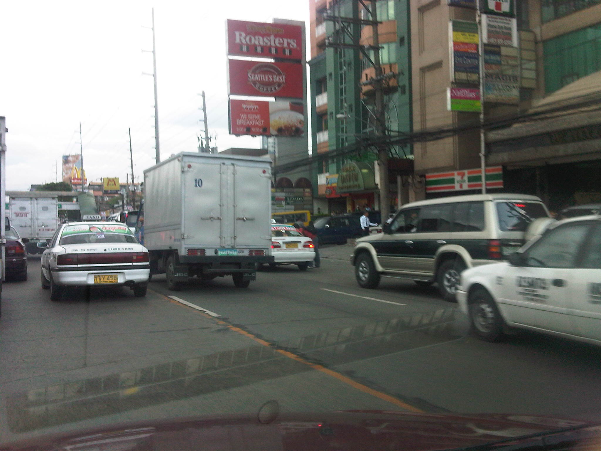
Traffic going bananas
I’ve written about land use and parking along Katipunan Avenue, which is part of Metro Manila’s Circumferential Road 5. Katipunan extends southwards to Blue Ridge, St. Ignatius and White Plains (the latter subdivisions just across the street from Camp Aguinaldo) where there are also many establishments along either side of the road. Most of these establishments are restaurants that attract significant private vehicle traffic. Note that there are no public transport routes along Katipunan/C5 in the Blue Ridge, St. Ignatius and White Plains areas. As such, establishments are more likely to attract people with cars rather than those taking public utility vehicles.
Many of these establishments are on lots formerly occupied by residential buildings (i.e., houses) considering the predominant land use in the areas. These were eventually purchased and converted for commercial use, resulting in layouts that generally do not include adequate parking spaces. The consequence of shortcomings in parking have been the propensity for on-street parking such as shown in the following photo in the Blue Ridge area.
 On-street parking for a popular restaurant/cafe along Katipunan/C5 at Blue Ridge.
Such case and many others like it along Katipunan (and other Metro Manila or Philippine cities roads) are the result of both poor planning and lax enforcement of traffic rules and regulations in this country. Being a primary arterial, Katipunan/C5 should be clear of such unnecessary sources of roadside friction that effectively decreases road capacities while also increasing the risk of crashes as vehicles maneuver, or in some cases wrestle, for parking spaces.
Katipunan parking predicament
Developments along Katipunan Avenue in Quezon City are good examples of fragmented land use and transport planning in Philippine cities. The developments, particularly the high rise condominiums have been the subject of much opposition from residents of subdivisions in the area as well as two major institutions of higher learning that have defined the stretch of Katipunan that has been developed in the 15 years. I mention 15 years because this is the period during which most of the high density developments along Katipunan have been constructed, apparently with the blessings of city hall. It is also in the last decade that schemes such as road widening and the U-turns were implemented.

On-street parking along Katipunan at lanes that used to be part of what was a west service road. In many cases, onstreet parking has been the result of a violation of a very basic provision of the National Building Code, which prescribes the minimum number of parking slots for establishments such as restaurants, shops, banks and offices. Despite being quite outdated and disconnected with more progressive parking generation principles, the NBC should have been a basis for the local government to assess whether minimum guidelines are satisfied, and perhaps impose penalties on those who are not able to comply such provisions. This is a fundamental case where individuals (owners of parked vehicles) impose external costs (e.g., congestion and crash risk) upon the general public.

Another look at onstreet parking just beneath the pedestrian overpass across from Ateneo’s Gate 2 – restaurants along Katipunan are major traffic generators and despite the presence of public transport (jeepneys and tricycles) a significant number of trips generated by these establishments use private vehicles including cars, vans and SUVs. Katipunan’s pedestrian facilities are inadequate as there are practically no sidewalks, thereby forcing people to walk along the road. This exposes many and particulrly students to risks like getting sideswiped by vehicles driven by reckless drivers.

Waiting vehicles effectively occupying 2 lanes of Katipunan – many employ drivers who can stay with the vehicles while the occupants eat, shop or transact at establishments. In most cases, standing vehicles are practically parked vehicles as they occupy road space. High-rise residential condominiums along Katipunan may have complied with minimum parking requirements stipulated in the NBC but their trip generation characteristics considering the commercial establishments located at the same buildings surely require many more parking spaces than what are available.

Congestion along Katipunan’s southbound side – may be caused by onstreet parking, standing (waiting), or vehicle maneuvers with respect to the limited parking slots fronting most establishments along the road. One tutorial center located near a U-turn slot, for example, generates significant vehicle traffic that it affects both U-turn and through traffic. Meanwhile, traffic enforcers seem either ineffective or helpless in their efforts to manage traffic, including preventing vehicles from taking 2 lanes of Katipunan.

Standing/waiting vehicles in front of a new development along Katipunan – the new building hosts several establishments including a major bank, a book shop, a popular gym, and several restaurants or cafes. Despite the potential for vehicle attraction, only a few parking spaces were provided, leaving all other vehicles and their drivers on their own to find parking spaces or just occupy road space in front of the building. The footbridge across Ateneo’s Gate 3 has been extended to the building but this obviously has marginal impact in reducing vehicle generation and parking demand.

Another photo showing the parking situation in front of the new building – while traffic is generally a manifestation of economic activity, one opinion is that many developers are irresponsible by designing buildings that have inadequate parking and resulting in the general public bearing the burden of traffic externalities. Add to this local governments that turn a blind eye on such discrepancies in design (who reviewed the design that obviously violated the building code?) only to be on the receiving end of complaints. In some cases, LGUs probably will be forced to shoulder costs of providing solutions that developers should have covered in the first place if they were responsible enough or made responsible for mitigating negative impacts of their projects.
In the end, it is inevitable that we need to address the root of the problem, which pertains to land use planning and the zoning policies LGUs are implementing. Consistency is one thing and being circumspect about established guidelines is another. Sustainable development, after all, does not pertain to continuous transformation from low to high density development but more about balancing elements that would preserve the character of neighborhoods and communities, particularly and most importantly to ensure that quality of life is not compromised.
Sustainability and the roads to Baguio
News about the garbage in Baguio City and the slide that caused the death of many in that city brought back memories of my last visit. That was back in June 2009 when we were conducting consultation workshops for the formulation of the national environmentally sustainable transport strategy. We stayed and held the workshop at a hotel that was a short walk away from the Good Shepherd Convent. The convent, of course, is famous for the strawberry jams and other delicacies bearing the convent’s name. Also nearby was the Mines View Park that used to give a breathtaking view of mountains covered with pine trees. Those among my older friends who were able to experience this many years ago attest to the pleasing scent of pine in the cool breeze that is also a characteristic of this city. Nowadays, the view is mainly of mountains covered with shanties and looking downwards you would have a good view of a lot of roofs and, surprise, even a couple of structures that look like graves! If you’re unlucky enough, you would be taking in the scent of smoke coming from something that is being burned nearby.
Another thing that caught my attention in 2009 was the uncollected garbage along the streets and in front of many houses and other buildings leading to the convent and the park. Residents explained to us that Baguio already had a garbage problem and that waste management and disposal has been an issue in the city for quite some time. Previous to this visit, I had the chance to go to the city a few other times, even staying there for almost week in 2004 when we were conducting another study. At that time, I was not aware of the garbage problem probably because the problem has not yet manifested itself as it did in 2009. It is sad that the city has done little to address such issues considering the many indications of impending (if not ongoing) disaster due to their waste. It is also disappointing to see their leaders pointing fingers at others but seemingly refusing to take responsibility for the tragedy of the garbage slide.
On the way up to Baguio, we usually take Kennon Road, which is usually my choice when riding our own vehicle, rather than the more common Marcos Highway. The latter is a relatively easier route that was constructed as a safer alternative to the two more traditional routes via Kennon or Naguilian Roads. I usually choose Kennon because the drive provides great vistas including those you can view from observations points along the road. During bad weather, however, Kennon and Naguilian can be treacherous with both being relatively narrow as compared to the newer and upgraded Marcos Highway. There are many incidences of rockslides or landslides that have often made these roads impassable. In fact, Kennon Road is usually only for light vehicles and can be challenging to those who are unfamiliar with its combination of curves and slopes. Naguilian is no longer a choice among travelers from Metro Manila as it starts further from both Kennon and Marcos. Buses and trucks commonly use Marcos Highway, which has slope protection along critical sections and even a roof along one that makes it look like a tunnel section. It is also easier to negotiate this highway for most motorists though there is one long climbing section just before you get off the highway that has caused many radiators to overheat or brakes and clutches to malfunction.
The photo below was taken as we negotiated a populated area along Kennon Road in 2009. Note the two jeepneys in the photo that are loaded with passengers. It was a surprise that no passengers were hanging by the door of the jeepney like what we usually see in Metro Manila during the peak hours. Nevertheless, such an image suggests that the public transport supply is no longer sufficient for the passenger demand along this route. Perhaps their numbers are no longer enough or maybe there is a need for a public utility vehicle with a larger capacity? One thing is sure and that the practice of overloading is unsafe and is a fatal crash waiting to happen given the geometry of Kennon Road. While this seems acceptable to many (I couldn’t even count how many people were sitting on the roofs of the jeepneys we passed.), this is not something that should be encouraged, and careful examination of services is necessary for both the local government (in this case Baguio) and the national agency in-charge (LTFRB).

More on Baguio and jeepneys on future posts.
Traffic and flooding
Metro Manila and other cities around the country are again in the headlines because of flooding brought about by strong rains. Rains are not new to the Philippines and there are many articles (and blogs) that have been written about the history of flooding in the Philippines. Some even feature old photos or caricatures showing how life was during the Spanish and American periods when floods also occurred, probably due to similar strong rains brought about by the monsoons or by the typical typhoons that regularly visit the country during the wet season.
In those times many years ago, the subject of drainage has already been mentioned and there is evidence that certain infrastructure were constructed to address the problems of flooding. In fact, the esteros that we presently associate with informal settlers and garbage were man-made waterways that functioned as open channels that could alleviate flooding in times of heavy rains. These waterways also functioned as transport facilities as they were constructed wide enough for boats to travel along the network of esteros that also connected with the Pasig River. These were not so different as the waterways that are now being used in Bangkok that have significant commuter and even goods traffic. There are many photos of these esteros as they were back in the Spanish and American periods. There are even more recent postwar photos that allow for comparison with photos at present. Unfortunately, I cannot post these here as there may be IP issues involved. Nevertheless, one can use your preferred search engines to find and view these photos.
Through the years, however, these esteros have been neglected and, as more and more squatters came to construct their shanties above the channels and tons of garbage disposed of, they became clogged and thus resulting to flooding in many parts of Manila. The esteros, however, are not wholly to blame when the subject of floods come up every now and again. It is a fact that the drainage systems of Metro Manila and other Philippine cities are already quite antiquated and their designs cannot accommodate the amounts of rainfall experienced these days. This is the result perhaps of poor planning and even more due to the neglect of national and local governments. And so we now experience floods almost each time we have significant rainfall. In some areas, the floods do not recede until after the wet season is over. Such is the sad plight of many Filipinos who are reduced to prayers and tests of faith if only to assure themselves that things will improve – some day.
Meanwhile, other cities have engaged similar flooding problems head-on and have invested on solutions that have saved their cities from much of the costs due to damages brought about by floods. Among those cities is Kuala Lumpur in Malaysia where they constructed a tunnel that is usable as part of their drainage system as well as a highway. Kuala Lumpur’s SMART Motorway Tunnel is an example of an engineering solution that could help alleviate flooding in Metro Manila. It is quite costly, with construction amounting to about USD 514.6 million at the time of its completion in the first quarter of 2007 with construction starting about 4 years earlier in 2003. Much has been written about this infrastructure and its benefits. It has saved KL and Malaysia from potentially disastrous flooding so many times now since its opening. Was it worth it? No doubt our Malaysian friends with tell us it is and will continue to save them from more floods years from now. Thus, the cost of such projects can easily be justified and the return in investment will be quite quick given the costs of flooding that have been compiling these past years including 2009’s Ondoy (Ketsana). In fact, KL’s SMART Motorway Tunnel is part of its tollway system and was built using a public-private partnership (PPP) arrangement that is much like what the current administration is preaching.
Perhaps its not yet too late for Metro Manila and other Philippine cities? Maybe we should get our acts together in finding and contributing to solutions that also address multiple problems facing our cities in this era of climate change and extreme weather conditions.
Technology-driven transit system development
The proposed UP transit system, whether it will be an AGT or a monorail, is a technology-driven project. As such, it can be argued that it does not need hard studies to establish the need for the system. Indeed, it is packaged as a prototype and one which, if implemented properly, will hopefully be a good example that can be deployed elsewhere where such a system is necessary. Such places may include CBDs like the rapidly emerging one in Bonifacio Global City or in small cities where there is a need for a more efficient form of mass transportation but could not afford the conventional MRTs or LRTs that have been constructed in Metro Manila. Also, a significant part of the initiative is the development of the vehicle, which is being undertaken by the DOST’s MIRDC. Their design and their production process should be replicable and they should have been able to bring down the costs according to the marching orders of their Secretary. After all, this system is being touted as something that would cost a fifth of a conventional system.
The conventional way of planning, designing and building transit systems require a lot of studies including the so-called ridership studies that would establish the demand for the system. Of course, there are also considerations pertaining to the stations and analysis of the superstructure that will also cost something. It is no joke that the best examples of AGTs or monorails in other countries are priced so because of all the effort and expertise that went into their developments. We should not kid ourselves by claiming this will cost much less because we did not take into consideration just compensation to people who will be devoting their time and expertise to develop a “home-grown” version of what has been built in other cities. We shouldn’t also sacrifice the quality of the superstructure that includes the stations just because we want to reduce costs. We have to keep in mind that the infrastructure should be able to resist typhoons and the possibility of earthquakes. The foundations for the columns, in fact, should be designed well considering UP’s soil characteristics.
On Wednesday I might just get my first look at the prototype vehicle when I visit the DOST for a meeting not quite related to the proposed transit system although it would be about customized vehicles. The vehicle that is the rolling stock for the proposed system is supposed to have already been built and being tested on a very limited basis at the DOST compound. Perhaps I can see for myself if it is something that will eventually be an impressive piece or something that will need much work once it is brought to UP.
Is it “Commonwealth” or “Commondeath” Avenue?
There is an excellent article appearing today in the Philippine Star written by Arch. Paulo Alcazaren aptly titled “‘Commondeath’ Avenue.” I stumbled on when it was shared by a friend, Dr. Dayo Montalbo, who is a faculty member of the UP School of Urban and Regional Planning. It provides a rare insight into the history of our highways and streets in Metro Manila. It is required reading for planners and engineers with backgrounds in civil engineering, architecture, urban planning, etc., and, I must say, for anyone who can appreciate history and how we seem to not have learned (or refused to learn) from it. It certainly should be required reading for students who want to become future planners and engineers.
When the MMDA “discovered” plans where it was indicated how wide the RROW for Commonwealth should be and started acquiring land left and right from those who were supposed to have been encroaching on the avenue, including UP Diliman, it apparently didn’t study the old plans and the context by which the capitol, Commonwealth, UP and other institutions where laid out back in the day. That interpretation translated into what we see now as probably the widest highway in the country.
I see the article as something that can be used by the DPWH and the MMDA as an input to whatever planning or engineering they plan along Commonwealth. The avenue is just too wide and definitely not friendly to people. Perhaps it should be transformed into the parkway it was meant to be in the first place.
National EST Strategy Formal Launch
The National Environmentally Sustainable Transport (EST) Strategy of the Philippines was formally launched yesterday, May 20, 2011. The formal launch event was held at the Columbus Room of the Discovery Suites along ADB Avenue in Ortigas Center, Pasig City. It was graced by the presence of top government officials including Secretary Jose “Ping” P. De Jesus of the Department of Transportation and Communications (DOTC) and Presidential Assistant on Climate Change Elisea “Bebet” Gozun, who was a former Secretary of the Department of Environment and Natural Resources (DENR). The DOTC came full force with Undersecretary for Planning and Policy Ruben Reinoso, Assistant Secretary for Planning George D. Esguerra, Office of Transport Cooperatives Chair Leticia Z. Gorrospe, consultant and former Assistant Secretary Alberto Suansing, and senior technical staff of the DOTC and its line agencies including the Land Transportation Office (LTO) and the Land Transport Franchising and Regulatory Board (LTFRB). The DOTC and the DENR are the national focal agencies for the project and will be expected to lead in the operationalization of the national strategy.
The supporting agencies and organizations were represented by Mr. Choudhury Rudra Mohanty of the United Nations Centre for Regional Development (UNCRD), Ms. Sophie Punte of the Clean Air Initiative for Asian Cities (CAI-Asia), and Mr. Akio Isomata, Minister of the Embassy of Japan to the Philippines, who represented his country’s Ministry of Environment. Development agencies and banks were also present with representatives from the World Bank (WB), the Asian Development Bank (ADB) and the Japan International Cooperation Agency (JICA). Also present were stakeholders led by the Partnership for Clean Air (PCA), Philippines – Global Road Safety Partnership (PGRSP), and the Firefly Brigade, and participants from local government units led by Quezon City and Marikina City. The national collaborating center was well represented by the study team from the National Center for Transportation Studies (NCTS) of the University of the Philippines Diliman.
The formal launch even began with the Opening Remarks from the UNCRD delivered by Mr. Mohanty and was followed by a Message from DOTC Sec. De Jesus. The formal messages were followed by a presentation of the highlights of the national strategy by D. Jose Regin F. Regidor, NCTS Director. Afterwards, a panel discussion with the theme “Operationalization of EST in Support of Sustainable Development in the Philippines.” The discussion was facilitated by Ms. Punte and Mr. Herbert Fabian of CAI-Asia. Panel members included DOTC Asst. Sec. Esguerra, WB Lead Transport Economist Baher El-Hifnawi, ADB GEF focal person Bruce Dunn, and Mactan Cebu International Airport Manager Nigel Paul C. Villarete, who is also a former City Planning Coordinator of Cebu City and who is an advocate of Bus Rapid Transit (BRT) in the Philippines. The formal launch event concluded with congratulatory messages from the Government of Japan and the Presidential Assistant for Climate Change, followed by a photo op for all in attendance that day.
 Mr. Mohanty of UNCRD delivering the Opening Remarks
 DOTC Sec. Ping De Jesus delivering a message from the Department
 NCTS Director Regidor presenting the highlights of the national EST strategy
 CAI-Asia’s Bert Fabian and Sophie Punte facilitated the panel discussion
 DOTC Asst. Sec. George D. Esguerra responding to the key questions during the panel discussion
 MCIAA’s Nigel Paul Villarete making his comments during the panel discussion
 Bruce Dunn explaining about the ADB’s initiatives
 The WB’s Baher El-Hifnawi stressing a point during the panel discussion
 Embassy of Japan Minister Isomata delivering a congratulatory message from the GOJ
 Presidential Asst. on Climate Change Bebet Gozun delivering the concluding message
 Group photo showing participants to the national EST strategy formal launch
The messages and the panel discussion were one in conveying a challenge to all stakeholders to use the framework provided by the national strategy to come up with action plans and implement these in order to realize sustainable transport in the country. It was also clear from the proceedings of the event that there should be a strong, collaborative effort among national agencies, local government units, NGOs, and development agencies if EST is to be operationalized and for programs and projects to succeed. Significant impacts would then be realized and perhaps lead to the alleviation of transport and traffic problems and their derivatives. It was emphasized that everyone should carefully consider the co-benefits that may be reaped from the implementation of EST.
For more on the national strategy including the reports and other resources, all these are available from the NESTS Web Portal hosted by the NCTS.
Going electric in the Philippines
The Asian Development Bank (ADB) hosted and co-organized a forum on electric vehicles with the Department of Energy (DOE) today. The forum was divided into two parts where the first part included remarks from the DOE Secretary and two presentations from invited speakers. The second part included mainly presentations of experiences in the deployment of electric vehicle technology around the country and a presentation by the ADB on their program to support electric vehicle deployment in the Philippines.
In the first part, the DOE Secretary was very clear in his message in support of electric vehicles. He emphasized the importance of addressing concerns pertaining to the use of fossil fuels, mentioning the need for fuel efficiency and our transport system’s (over)dependence on fossil fuels. He also expressed concern over environmental aspects, recognizing the direct association between emissions and fuel consumption. His remarks was followed by two presentations on experiences on electric vehicle applications abroad. One presentation was mainly on the infrastructure for charging e-vehicles and included material on the experiences in China. Another was on battery technology but included also the different e-cars that are currently available in the market (e.g., Volt, Leaf, Tesla, etc.).
I must admit, modesty aside, that I was disappointed with the presentations as they were both mainly on private vehicle applications including electric motorcycles and electric cars. I was unimpressed, as were others, with the presentations that had material one could easily pick out of the internet. Even information on battery technology did not provide any new knowledge to most participants that included proponents/advocates of electric vehicles in the Philippines. The comment of one participant said it all when he mentioned that in the Philippines the focus was on public transport applications of e-vehicles.
The second part was more interesting, although two presenters tended to stray away from the topic of electric vehicles. The first presentation of the second part of the forum was delivered by the Congressman representing Taguig City. He did not use any slides but chose to make a rambling speech on Taguig’s experience during his time as mayor of the city. He explained his administration’s push for the e-trikes in Bonifacio Global City and made it appear as if his administration was progressive in its push and that the private sector (i.e., Ayala Land, which had a say on transport at BGC) did not have foresight. In truth, the question that needed to be answered at the time of their push was if the e-trike was the appropriate transport mode at the Fort. Ayala knew it was not but it was clear that Taguig insisted on the deployment of e-trikes at BGC rather than take the more progressive (radically) yet risky push of replacing conventional tricycles in the old Taguig east of C5. His speech was really more a conscious delivery of soundbites and I must say, was quite pretentious and self-serving. It was, for me, simply lip service and a waste of time. In fact, one person near us was already snoring by the time the Congressman finished his speech.
The second presentation was delivered by a representative of the Puerto Princesa Mayor. It was straightforward and wasted no time in explaining PPC’s programs and clearly showed their efforts in deploying environment-friendly transport systems. He also mentioned the incentives that the city has so far offered and proceeded to ask those present to partner with them in promoting e-vehicle use.
The third presentation was on Makati’s experience on electric vehicles. The presenter was city’s traffic consultant and I was expecting him to focus on the electric jeepneys now operating along three routes in that city’s central business district. Instead, he took up much time presenting on Makati’s transport plan including the proposed Bus Rapid Transit (BRT) system and its extensive pedestrian facilities that included walkways connecting buildings and to the shopping district. Nevertheless, his presentation had its saving grace in that it mentioned how the e-jeepney could serve as feeders to the BRT and how the pedestrian facilities complemented public transport services.
The fourth presentation was by a representative of Mandaluyong City, which is the first recipient of the incentives being granted by the ADB in support of e-vehicles. This was another straightforward presentation and clearly covered the main points of the e-trike application in that city including the infrastructure they put up for charging. These charging stations represented an innovation that can be picked up by entrepreneurs in coming up with a business model for charging stations. It was not clear though if Mandaluyong has set out to replace conventional tricycles as my impression was that the e-trikes they acquired will be on top of the existing tricycles plying routes around the city.
The fifth presentation was from Ateneo De Manila University, and focused on that school’s efforts to pilot e-vehicles for the use of their students and staff. The presentation mentioned their rationale and the apparent marching orders from their newly installed president, who is an acknowledged expert on environment, to address air quality in the vicinity of the campus. I found their presentation awkward and at the very least hypocritical of the fact that the problem they have to face is the overwhelming number of private vehicles the school generates and their continuing coddling of tricycles whose phase out along Katipunan is long overdue. Perhaps I will expound on this and other issues when I write about Katipunan transport and traffic in the future.
The last presentation was a quick one from the ADB. It was mainly on the ADB’s program supporting e-vehicle promotion. It was also explained why ADB chose to focus on tricycles and was unapologetic in their argument that tended to generalize the problem on transport in the Philippines. There was no mention of rationalization considering that there is actually an oversupply of tricycles and this too needs to be addressed.
While it is commendable that the ADB has extended assistance in the form of grants incentives to promote e-vehicles, there are still questions on the sustainability of this effort given that they chose to focus on tricycles. Of course, the statistics on the number of tricycles and their environmental and energy impacts clearly argue for addressing this problem pertaining to conventional motor tricycles. However, the ADB must realize that local government units (LGUs) can be quite fickle-minded or hard-headed in their approaches to public transport regulations. This is a fact given that there are few LGUs that have been successful in regulating tricycles and particularly in restricting their numbers and their operations along routes or areas where they are suitable. If we take a look at many cities, we will find tricycles running on national roads and causing congestion in CBDs. We would also see that many of these cities, among them highly urbanized cities (HUCs), have a need to graduate from these low capacity modes into middle or even high capacity vehicles.
It was noticeable that there were no representatives from the Department of Transportation and Communications (DOTC) nor its attached agencies like the Land Transportation Office (LTO) and the Land Transport Franchising and Regulatory Board (LTFRB) at the forum. Despite pronouncements by the DOE Secretary that the DOTC and the Department of Science and Technology (DOST) were on-board in the former’s push for e-vehicles, experience has shown that DOTC and its attached agencies have been the bottlenecks in the forward movement of e-vehicles. This includes the absence of clear policies pertaining to e-vehicles including their registration as well as the lack of direction pertaining to their mainstreaming as public transport modes (i.e., franchises). Also, lest we forget, all the talk on e-vehicles while being spearheaded by the DOE, is very much the province of the DOTC since we are, after all, talking about transport. It is the main responsibility and the mandate of the DOTC to see the e-vehicles through and lead in the mainstreaming of these vehicles in the context of environmentally sustainable transport. It is a pitch for e-vehicles that would go a long way into ensuring that a critical mass can be realized and that the tipping point for the shift to electric would be reached in the near future.
National EST Strategy Update
The Third Draft (Draft Final Report) of the National Environmentally Sustainable Transport (EST) Strategy (NESTS) formulation study for the Philippines has just been completed. The report is available online via the NESTS Web Portal on the NCTS website. The project is concluding in May 2011 after more than 2 years of developing strategies covering twelve (12) thematic areas as defined by the Aichi Statement of 2005.
The report articulating strategies, indicators and key result activities is written in general terms to allow for flexibility in the further development of strategies and action plans to realize EST. The document is envisioned to be a guide for both national agencies and local government units, as well as for other stakeholders such as non-government organizations (NGOs) and private entities seeking to take on EST as an advocacy.
The National EST Strategy will be formally launched on May 20, 2011.
Airport parking
I’ve been to Metro Manila’s airport terminals quite frequently lately. It’s only March but I’ve traveled to Singapore twice, once using NAIA Terminal 2 for a Philippine Airlines flight in January, and again last February but using Terminal 3 for a Cebu Pacific flight. I’ve gone to Terminal 1 several times as I either dropped off or fetched the wife who flew in and out via either Singapore Airlines or Tiger Airways. Every time I went to any of the three airports, and especially when I was fetching someone, I couldn’t help but make some observations about the parking.
I’ve been to many airports including the huge modern ones in our neighboring countries. I must admit that I haven’t had the chance of using their parking facilities first hand. Most of the time I use public transportation from and to the terminals like when I use Changi or Suvarnabhumi. I have seen their parking buildings from the outside though. And I can say that my impression is that they are sufficient for their purpose whether their users be well wishers, people fetching relatives or friends, or travelers opting to leave their vehicles to return for them on their ways back.
I must say that the parking facilities of the three NAIA terminals can be viewed as a progressive case considering that there have been steady and obvious improvements when comparing features from Terminal 1 to 3. I won’t get into the technical aspects as qualitative assessment from fellow users like friends and colleagues point out that NAIA 1’s parking seem to be always full as with Terminal 2’s. The latter is quite unusual as it is used exclusively by PAL. Terminal 3 should have the largest capacity and this was expected for a terminal whose designers should have learned from the lessons of Terminals 1 and 2. However, in my recent trips to all three airports, my experiences have been quite the contrary in terms of finding a parking slot that is convenient enough; that is, not so far a walk from the respective terminal buildings.
It was surprising for me to find good parking slots in my most recent trips to NAIA 1 and 2. Meanwhile, parking at Terminal 3 seemed to be laborious especially considering the linear layout of the open parking facility. In that last sentence, allow me to emphasize open and add to it “outdoor” since Terminal 3 is supposed to have a multi-level parking building. This was supposed to be one of its features distinguishing it from 1 and 2. The problem is that airport officials have not given the go signal for this multi-level facility to be operational. This causes problems to airport users considering that there is a significant number of vehicles left by their owners for their return trips. These include overnight parkers who probably took a local trip with a schedule that prevented them from returning the same day. All these vehicles are parked along what should be a lane dedicated for traffic circulation. In fact, the line of parked vehicles extend all the way to the ramp leading to the entrance to the parking building.
Perhaps it is already time to open the parking building to the general public. It doesn’t take a genius to see that parking at NAIA 3 is already insufficient given the travel characteristics of its users. Operational costs including maintenance and security should not be a problem since users will be charged fees according to their parking durations. Also, a variety of services may be offered to users including cleaning like the ones offered in shopping malls and even quick repairs for those encountering some trouble with their engines or tires. It shouldn’t be so difficult to come up with a system for parking management that would enhance NAIA 3’s services. And it should be done now and not later.
I have other impressions of parking in the other terminals I have had the opportunity to use across the country including those of international airport in Mactan, Cebu and Davao. But these terminals do not generally serve as many people as Manila’s three terminals do so their assessments would have to be tempered against this backdrop.
