
Home » NMT (Page 13)
Category Archives: NMT
Incomplete rationalisation of public transport?
The current initiative to rationalise road public transport services is not as comprehensive as necessary or as some people want us to believe. The drive appears to be mainly on (some say against) jeepneys while little has been done on buses and UV Express vehicles. Most notable among the modes not covered by rationalisation are the tricycles.
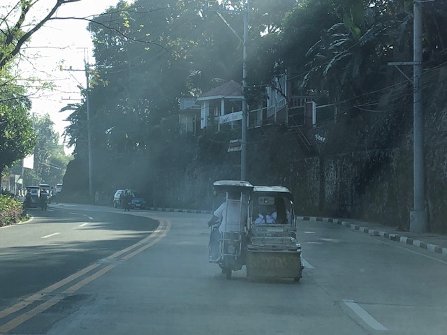 A smoke-belching tricycle along Daang Bakal in Antipolo City
What really should be the role and place of tricycles in the scheme of themes in public transportation? Are they supposed to provide “last mile” services along with walking and pedicabs (non-motorised 3-wheelers)? Or are they supposed to be another mode competing with jeepneys, buses and vans over distances longer than what they are supposed to be covering? It seems that the convenient excuse for not dealing with them is that tricycles are supposed to be under local governments. That should not be the case and I believe national agencies such as the DOTr and LTFRB should assert their authority but (of course) in close cooperation with LGUs to include tricycles in the rationalisation activities. Only then can we have a more complete rationalisation of transport services for the benefit of everyone.
–
In support of bike lanes
Here is another interesting article about bike lanes but from the perspective of a non-cyclist. I believe this (support for bike lanes) is a view shared by many but not much articulated. The assumption is usually that car-owners would like to have less of other’s cars on the road so they could benefit from the presumed reduction in congestion should more people take up cycling. But then the same can be said for public transportation and its users as well. That is, car-users would want others to take public transport so as to also reduce road congestion; allowing them faster trips/drives.
Lewyn, M. (2018) “A Non-Cyclist’s Case for Bike Lanes,” planetizen.com, https://www.planetizen.com/node/97632?utm_source=newswire&utm_medium=email&utm_campaign=news-03152018&mc_cid=0e22636014&mc_eid=9ccfe464b1 [Last accessed: 3/17/2018]
–
On child-friendly cities
Here’s another article that I want to share. This time it is about child-friendly cities. Here is an article that present many good practice examples in other cities. Many are easily replicable in our towns and cities, and should be considered by local governments in order to enhance safety and health aspects in their jurisdictions.
Laker, L. (2018) “What would the ultimate child-friendly city look like?”, theguardian.com, https://www.theguardian.com/cities/2018/feb/28/child-friendly-city-indoors-playing-healthy-sociable-outdoors [Last accessed 3/9/2018]
–
On the Pasig HOV lane experiment, again
I recently wrote about some thoughts on Pasig City’s HOV lane experiment along Julia Vargas Avenue. Here are a few more considering the experiment didn’t push through last February 28.
 Screen cap (courtesy of ABS CBN) showing the starting date for the HOV lane experiment. I think ‘HOV’ is more appropriate than ‘carpool’ since the requirement is for vehicles using the lane to have 4 or more passengers. Having only 2 passengers still qualify as a carpool.
I learned recently that the experiment has been put off to March 26, 2018:
 [Photo courtesy of Dulce Justiniani]
The current set-up has 2 lanes for motorised vehicles including a wide lane for HOV’s (including public utility vehicles like buses and vans). HOV’s here also include cars but those with at least 4 occupants. Here are a couple of photos showing us what could possibly happen should enforcement be weak given the configuration of the lanes along Julia Vargas:
 Private van running along the lane designated for HOV’s alongside a solitary cyclist on the bike lane.
 An SUV overtaking the van via the bike lane and the extra space of the HOV lane.
Wide lanes generally encourage higher speeds. I believe the way to go would be to have narrower lanes. And should these be considered, it would be possible to have 3 lanes for motorised traffic with one assigned for HOV’s and another for motorcycles. These are aside from the bicycle lane that I think should also be a protected lane. Protection here may be through the provision of “forgiving” physical dividers in the form of, say, rubber bollards.
Here’s how the Julia Vargas carriageway could be laid out:

Again, these are just suggestions for whoever are in-charge of the experiment-to-be along Julia Vargas Avenue. I hope that they are able to make some assessments even prior to the experiment. Such can be done using simulation software in order to have a handle on traffic related issues that may crop up during the implementation. Still, a big factor would be the enforcement aspects of the proposed policy for motor vehicles. Strict, firm and sustained enforcement would be necessary in order for this to succeed.
–
On prioritising pedestrians and promoting walking
We begin March with an excellent article that came out from curbed.com:
Walker, A. (2018) The case against sidewalks and how cities can create new avenues for pedestrians, curbed.com, https://www.curbed.com/2018/2/7/16980682/city-sidewalk-repair-future-walking-neighborhood [Last accessed 2/23/2018].
How do we improve the environment (i.e., facilities) to encourage people to walk? Do we simply clear up sidewalks? Widen them? Build overpasses and underpasses? What should be the context for improving pedestrian facilities for our cities and municipalities? What are the implications to planning and design?
–
Another walkability tool: Pedestrians First
The ITDP recently came out with a new walkability tool called Pedestrians First. Here’s the link to their site where you can download the tool. The tool was released in the recently concluded World Urban Forum held in Malaysia.
https://www.itdp.org/publication/walkability-tool/
Of course, there are other tools out there including one developed by Clean Air Asia, material on which may be found through the following links:
http://cleanairasia.org/walkability-study-in-asian-cities-4/
Our technical staff and my students are currently using the methodology developed by Clean Air Asia and have covered several major thoroughfares in Metro Manila and a highly urbanized city in studies that have been undertaken in the last 6 years. I already asked them to take a look at the new tool and see how this compares with the ones we are using.
–
On riding bicycles slowly
I saw this interesting article on cycling/biking that I thought was quite relevant to the situation we have on campus. The University of the Philippines Diliman campus has a bike lane along the inner side of its Academic Oval that has been used by various cyclist types. There are those who use their bikes for commuting or going around campus (e.g., students traveling between buildings for their classes, messengers bringing documents, etc.). There are those biking in a more relaxed manner (i.e., for recreation). And then there are those who bike for fitness including those racing around the oval. It is from the latter that UP Diliman has received complaints about conflicts with joggers, motor vehicles and fellow cyclists. But then UP has maintained that the bike lane is not for racing or taking laps around the oval. It was created to have a segregated (and in the future maybe protected) lane to enhance mobility more than any other purpose.
Babin, T. (2018) “How to ride a bike slowly (and why you would want to),” Medium.com, https://medium.com/shifter/how-to-ride-a-bike-slowly-and-why-you-would-want-to-b544ec869846 [Last accessed: 2/4/2018].
 UP Diliman’s Academic Oval now features a bike lane between a jogging/walking lane and the lanes assigned for motorised traffic. The ice cream vendor on a NMT 3-wheeler is running on the bike lane.
–
On the future of city streets
Here is another article, this time on the future of city streets. I had been sharing many of the ideas related in the article in the Transportation Engineering courses that I handle including those pertaining to the Complete Streets concept and road diets. The article is good reading material for my students who need to get out of the box (so to speak) of traditional civil engineering thinking regarding highways and streets. That is, we need to do more people-centred rather than car-centric designs.
Davidson, J. (2018) “What Is a City Street? And What Will It Become?”. New York Magazine. http://nymag.com/daily/intelligencer/2018/01/what-is-a-city-street-and-what-will-it-become.html [Last accessed: 2/2/2018].
Here is a photo I took in Iloilo City a couple of years ago showing the bikeway along the Diversion Road. The facility then was underutilized but was supposed to represent, along with the Promenade along the river and the redevelopment of the old airport site in Mandurriao, the revitalisation of the city. Meanwhile, there have been little done for the downtown streets.

Iloilo City provides a good example of the need to have a more holistic transformation rather than have some exhibition or demonstration pieces for inclusive transport here and there.
–
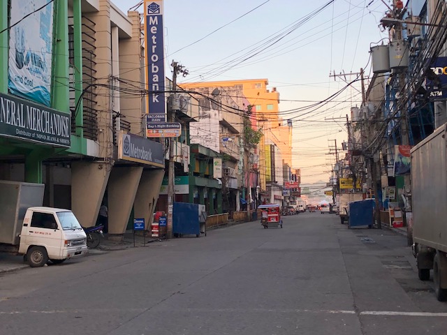
Tacloban downtown in the early mornings
Mobilizing surveyors for traffic data collection in Tacloban City’s downtown, I took the opportunity to take some photos before 6:00AM. This was before most people were at work or school on the first good weather day in the city after a week of heavy rains that brought floods and landslides to parts of the city. Schools at all levels had been suspended earlier this week with government offices also closed last Monday.
 Zamora Street towards southeast and M.H. Del Pilar Street
 Zamora Street towards northwest and Salazar Street
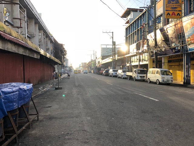 Justice Romualdez Street to southwest and M.H. Del Pilar Street
 A lone cyclist along Justice Romualdez Street
There’s something about coming out to walk in the early morning in cities like Tacloban. You catch a city at a time before all the action happens, when everything seems so peaceful and calm when you see more people walking and cycling than motor vehicles dominating road space. That serenity should serve as an inspiration for what should be the vision for a city in order for it to retain its soul rather than lose it in what can be nightmarish traffic and transport conditions. Tacloban’s downtown holds so much promise for revitalisation but among the issues that need to be addressed is traffic-related. The city needs to recover spaces for pedestrians and cyclists while ensuring efficient traffic circulation for motor vehicles, particularly public transport. There seems to be spaces available for road diets and the creation of safe paths for people, and such design challenges need to be taken on in order to transform the downtown area into an example of sustainable transport.
–
New guidelines for bikeways
I want to share an article discussing new guidelines for bikeways released in the US.
Andersen, M. (2017) “Which Bike Lanes Should Be Protected? New Guide Offers Specifics,” Streets Blog USA, https://usa.streetsblog.org/2017/11/01/which-bike-lanes-should-be-protected-new-guide-offers-specifics/ (Last accessed 11/16/2017)
This is useful not only for practitioners or planners but also for academic purposes such as in transportation planning or engineering courses where future planners and engineers are molded.
–
