
Home » NMT (Page 12)
Category Archives: NMT
Shoes made in Marikina
This seems to be an odd topic for this blog at first but then shoes are very much related to transportation. You have to have a good pair of shoes on you for walking, jogging or running. There are even driving shoes and boat shoes (i.e., those docksides and topsiders were originally made for boating or walking along the seaside). And so I write this short article about shoes; particularly those made in Marikina.
Marikina is well-known for its shoemaking industry. It used to be a major industry that manufactured shoes that were popular throughout the country as well as being exported for sale abroad. These were mainly handmade using techniques and skills passed on from one generation to the next. It was not uncommon for families to be involved in shoemaking and the brands of many shoes carry the names (or combinations) of families involved in the business. There was even a Marikina Shoe Expo in Cubao where I recall we had bought many pairs of shoes for school and casual days. Among the brands I remember were Chancellor, Valentino and Cardams. There is also a Shoe Avenue in the city along which many shops are located. In many cases, these are also the factories themselves.
The industry suffered due to a combination of automation (i.e., mass production) and the influx of cheap shoes from China. Without government support for the industry, many, regardless of whether they were small or big, eventually seized shoemaking. Those who survived and those who were revived are the ones you still see. And then there are upstarts who have been encouraged by the support now being provided by the city government. One venue for this support is through a “Sapatos Festival” that the city organises to promote shoes and other footwear made in Marikina.
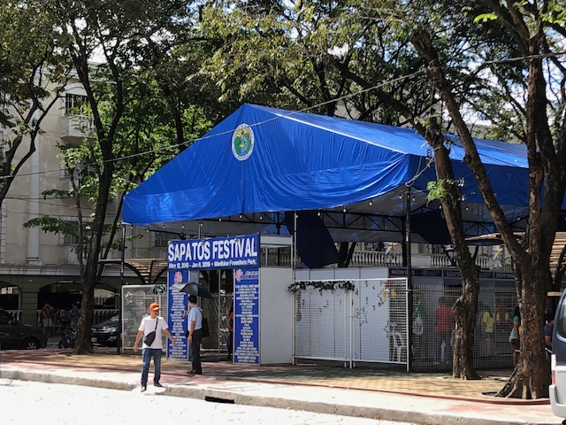 The Sapatos Festival was held right across from the Marikina City Hall.
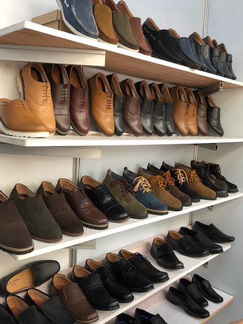 One could find a variety of footwear using various materials including genuine leather, rubber, faux leather, etc. This photo shows men’s shoes being sold at one of the shops there.
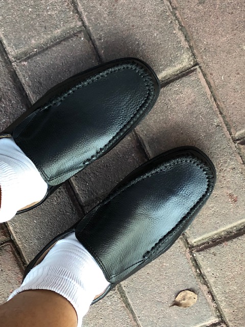 I tried on a pair I fancied and after the typical examination of workmanship and quality, I decided to buy this pair for 900 pesos (about 9 US dollars!).
Marikina-made footwear and bags are also sold at the Riverbanks mall that used to be a textile factory complex. These are inexpensive yet very good quality products that I think we should re-discover and support. Perhaps we should also provide constructive comments or suggestions on how the makers can further improve their products in order for them to be able to compete with the mass-produced variety. There is definitely a market for well-made footwear whether you walk, take public transport or drive.
–
The Julia Vargas Avenue protected bike lane
I thought I already posted an update on the Julia Vargas Avenue in Pasig City. It turned out I was only able to upload photos on my folder but wasn’t able to get to writing about the bike lane. And so we conclude the year 2018 with a positive post of something we would like to see more in 2019 and beyond. We are hopeful that the protected bike lanes along Julia Vargas Avenue, connecting C-5 with the Ortigas Center, will expand and that this example along those of its predecessor bikeways in Marikina and Iloilo would be replicated across the country particularly in highly urbanised cities.
 A view of the westbound bike lane along Julia Vargas at the Ortigas Center. Note that the eastbound bike lane (visible in this photo) is not similarly protected vs. motor vehicle encroachments. It would be preferable for that lane to be protected, too. Parang bitin pa tuloy ang effort nila.
 Another view of the protected bike lane along the westbound side of Julia Vargas Avenue in contrast with the obviously congested lanes available for motor vehicles.
The middle lanes of the carriageway are wide and can accommodate motorcycles though the latter always seem to prefer filtering or splitting the lanes. The median lanes are generally for low occupancy vehicles (less than 3 passengers) while the middle ones are for high occupancy vehicles (3 or more passengers) including UV Express vans and buses.
Happy New Year to all!
–
On re-designing or re-imagining our transportation system for people
Here is another good read especially for those who advocate or even just beginning to appreciate the concept of people-oriented transportation:
VannPashak, J. (2018) “Design for humans as they are, not as you want them to be,” http://www.medium.com, https://medium.com/@jvannpashak/design-for-humans-as-they-are-not-as-you-want-them-to-be-ef95076c0988 [Last accessed: 11/23/2018].
In a recent symposium where I made a presentation about low carbon transport and visioning and re-imagining transport, I was asked how we can re-design our transportation to be more people-oriented than car-oriented. I replied that we have to do a lot of unlearning. That is, many planners and engineers would need to unlearn many things they’ve learned in school and those they got from their workplace. One convenient excuse for not coming up with a better design, for example, is that certain planners or engineers just followed what their offices or agencies have been doing. What if what their offices and agencies (and consequently their seniors at work) where wrong all these years and what was “ginagawa na” or “nakasanayan” have led to deficient outcomes? I even joked about whether these offices or agencies were “open minded” referring to a favourite by-line by networking companies. Being open-minded in the context of having people-oriented transport solutions would be difficult if everything was “nakakahon” because these were what you learned from school and/or the workplace. It is difficult to admit that something was and is wrong.
–
On school trip generation
I chanced upon the changing of the shifts for a national high school. This was the time of day when the morning shift students were dismissed (i.e., coming out of school) and the afternoon shift students were coming in.
 Students come out of the school to mainly either walk or take public transport (mostly tricycles) to their homes.
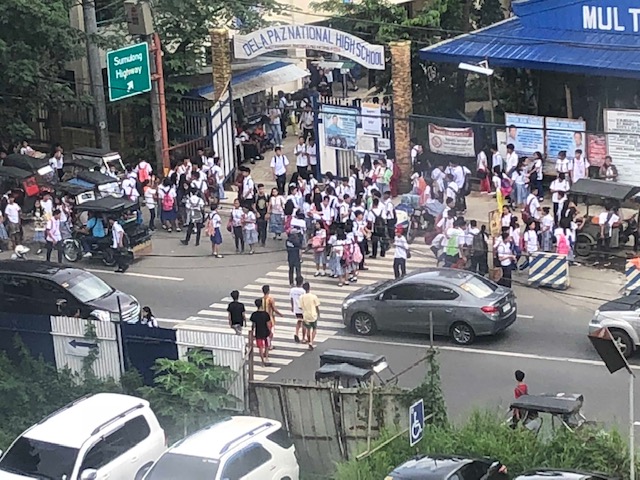 Most vehicles give way to people, especially students, crossing the busy street. There are usually traffic aides in the area who help manage traffic and to ensure pedestrians may safely cross or move about.
There are no severe traffic congestion here unlike those generated by many exclusive or private schools. There is actually a private school just beside this public high school that also generates significant private vehicle traffic but somehow manages not to congest this major road that’s part of the L. Sumulong Memorial Circle the way another private school congests Sumulong Highway in the mornings.
Is this simply because of the school being a public school as compared with private schools? Perhaps it is, given the perceived disparity in income classes concerning those going to typical public schools and those going to typical exclusive schools. But income disparity aside, wouldn’t it be possible for most students to just walk or take public transport to school? I actually envy the public school students in the photos above as they can walk to school. And that is because they likely live near the school, which is something that is a desirable situation if public schools are at least at par in quality with the more established private schools (especially the sectarian ones where many parents likely prefer their children to go to). This disparity in quality leads to people residing in relatively long distances away for the preferred schools to travel (often with their private vehicles) to and from the exclusive schools. The point here is that it really is more complicated than what it seems in terms of trip generation.
–
On the need for more facilities for cycling and ensuring they will be used for cycling
I read and hear a lot of comments about two particular items: pedestrian overpasses and bike lanes. Most of the comments call for pedestrians and cyclists to have priority over cars and for the latter to give way to pedestrians and cyclists every time. The hardline stance for some is for the pedestrians to be allowed to cross anywhere and for cyclists to be able to bike on any lane they choose to. Of course, the concerns about these are quite obvious and safety still calls for people, no matter what mode they choose, to use the appropriate spaces. What few actually discuss and delve into are design solutions to these problems. Many cite good practices elsewhere but stop at sharing these and not really going into in-depth and constructive discussions on how to implement these good designs here. Most of the time its just “the government must do this” and “the government must do like what (insert city or country) is doing”. Worse are those who tend to simplify it as an “architect vs. civil engineer vs. planner” kind of conflict. Playing the blame game doesn’t get us anywhere if we wanted the planning and design of transportation infrastructure improved.
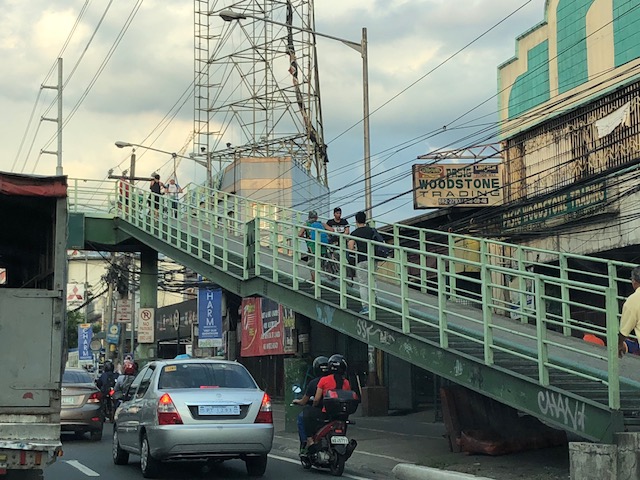 Cyclists use the overpasses to cross the wide Marcos Highway between Pasig and Marikina. There are only 2 ramps, one each on either side of the highway and it partly occupies the sidewalk beneath. Could there be a better design for such overpasses?
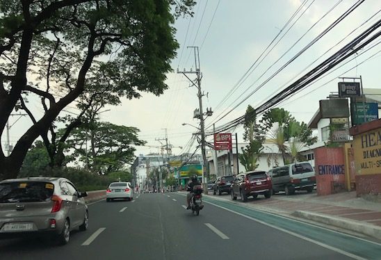
 Motorcycles using the bike lanes along Ortigas Avenue. How do we make sure that spaces are utilised according to their intended users? How do we design these spaces to include elements that will deter such incursions?
There are many references out there showing us what good design should be from the technical and social perspectives. Surely these can be taken up not only at the workplace for architects, engineers and planners but in schools where such principles are supposed to be learned and inculcated into the minds of future architects, engineers and planners.
–
On the need to increase NMT and public transport use
A recent report reinforces what many of us already probably know or are aware of – that we need to shift away from dependence on car use to more sustainable modes of transport in the form of non-motorised transport (NMT) and public transportation. Here is the article from the AASHTO Journal:
Global Climate Report Calls For Expansion Of ‘Non-Motorized’ Transport And Public Transit (2018)
There is a link to the report in the journal article. The report is conveniently available in PDF form and is very readable (i.e., not overly technical).
Incidentally, I was involved some time ago in a project led by the group Clean Air Asia (CAA), which involved several experts from across ASEAN as well as Japan that attempted to determine the necessary transport programs and projects in the region to stave off the projected increase in global temperatures. In all the scenarios evaluated, non-motorised transport (NMT) and a rationalised public transportation system By the term ‘rationalised’ I am referring to the use of higher capacity vehicles as against the taxis and tricycles that typically carry few if not one passenger. Here is a link to the final symposium for that study that has links to the materials presented:
The Final Symposium on the “Study on Long Term Transport Action Plan for ASEAN”
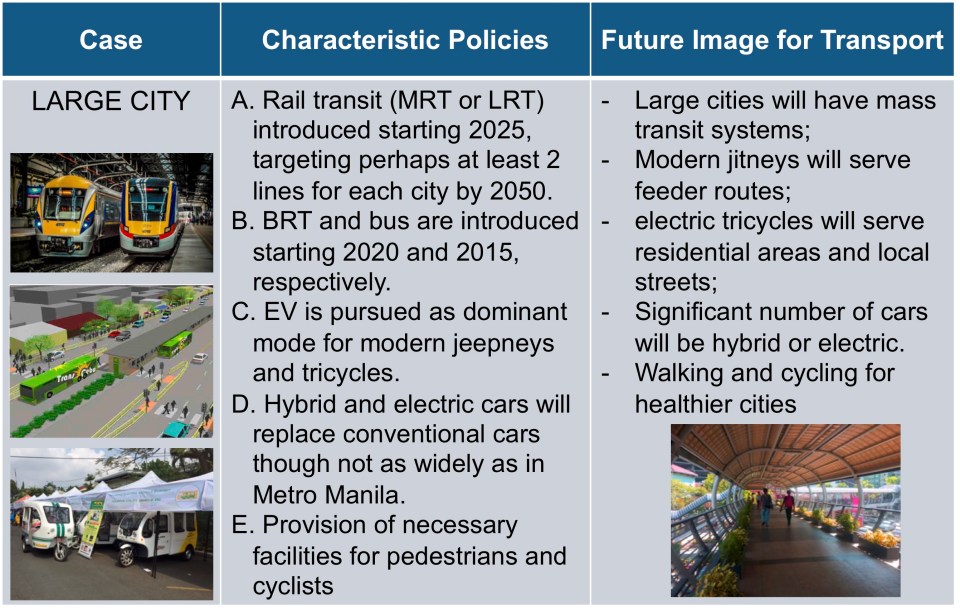
Here’s a slightly updated slide on the future image for a large city in the Philippines:
–
On healthier cities and encouraging walking
It’s a Sunday and the sun is up after days of rain so it would be a good time to be outdoors. Here is a nice article for the fitness buffs out there. Many of us have sedentary lifestyles and this has come as no surprise with the how we work and study as well as the influence of tech in our everyday activities. Even as I write this, I am sitting in front of my desk and have only my fingers and hands working. The rest of me is inactive except perhaps my senses and my brain. 🙂
Merle, A. (2018) “The Healthiest People in the World Don’t Go to the Gym,” medium.com, https://medium.com/s/story/the-healthiest-people-in-the-world-dont-go-to-the-gym-d3eb6bb1e7d0 [Last accessed: 8/1/2018].
I miss the times when I was living in Japan and when we were living in Singapore mainly because I was able to have a more active lifestyle in the cities where I lived. I walked and biked a lot when I was in Yokohama, Tokyo and Saitama, and later walked a lot around Singapore. I/we didn’t need a car as the public transportation was excellent and so were the pedestrian infrastructure. I recall walking between our laboratory at Yokohama National University and the dormitory, and later the Sotetsu Line Kami-Hoshikawa Station almost everyday. And then climbing up and down the hills of Yamate on Sundays. I can walk around Tokyo on my own and finding my way through shopping streets especially in Akihabara and Ueno. Of course, my favourite places would always include Kamakura, which can be reached via a train ride from Yokohama Station. The wife and I loved walking around Singapore and exploring places on foot. Indeed, you can be healthy and have a workout everyday without being too conscious about it!
–
A compilation of studies on walkability in the Philippines
My students have been engaged in studies on walkability (and related topics) the past few years. These have been a mix of published and unpublished work that I have compiled at list below:
Unpublished works:
- Capalar, M.A.M. and Garma, F.A.A. (2018) Assessment of Walkability Along Taft Avenue, Unpublished Research Report, Institute of Civil Engineering, University of the Philippines, Diliman
- Pajarin, J.B., Soriano, C.M. and Regidor, J.R.F. (2017) Assessment of Mobility of Persons with Disabilities (PWDs) in Cainta, Rizal, Unpublished Research Report, Institute of Civil Engineering, University of the Philippines, Diliman.
- Cortez, E.H.D. and Razon, J.V.DV. (2017) Assessment of Walkability Along Katipunan Avenue, Unpublished Research Report, Institute of Civil Engineering, University of the Philippines, Diliman.
- Marcelo, K.R.S. and Salvador, J.P.B. (2015) Assessment of Pedestrian Facilities Along Marcos Highway, Unpublished Research Report, Institute of Civil Engineering, University of the Philippines, Diliman.
Published works:
• Pajarin, J.B., Soriano, C.M. and Regidor, J.R.F. (2018) “Assessment of Mobility of Persons with Disabilities (PWDs) in Cainta, Rizal,” Philippines Transportation Journal, Vol. 1, No. 1, pp. 60-80.
• Pajarin, J.B., Soriano, C.M. and Regidor, J.R.F. (2017) “Assessment of Mobility of Persons with Disabilities (PWDs) in Cainta, Rizal,” Proceedings of the 24th Annual Conference of the Transportation Science Society of the Philippines, Quezon City, July 21, 2017.
• Regidor, J.R.F., Marcelo, K.R.S. and Salvador, J.P.B. (2016) “Assessment of Pedestrian Facilities Along Marcos Highway,” Proceedings of the DPWH Research Symposium 2016, Quezon City, September 2016.
Here’s a paper based on a comprehensive study our centre conducted for the City of Olongapo in the Province of Zambales:
• Palmiano, H.S.O., Javier, S.F.D. and Regidor, J.R.F. (2015) “An Assessment of Walkability in a Medium-Sized Philippine City,” Proceedings of the Eastern Asia Society for Transportation Studies, Vol. 10, December 2015.
We hope to continue such studies with future advisees who perhaps can tackle other corridors or even areas. Among those on my Wishlist would be Espana Avenue, Ortigas Avenue, Intramuros, Recto Avenue, and even EDSA or Circumferential Road 5.
–
Park and ride near the Line 2 Santolan Station?
These days when there are heavy rains and the threat of flooding, the Marikina river and its riverbanks come to mind. In the Santolan area, where a former Mayor of Marikina has invested a lot in developing a bus terminal, he seems to be stretching it in terms of trying to make the area a major intermodal terminal and maximising utility of the land. The latest venture is described by the sign below:
 “Park and ride” sign along the Marcos Highway Bridge crossing the Marikina River
A closer look at the sign shows what’s written at the lower part. That is, that the parking spaces are “walking distance” from the Line 2 Santolan Station. I’m not sure if they measured the actual walking distance and what it would take to walk that distance between this parking area for the “park and ride” and the Line 2 Santolan Station. A quick measurement using Google Maps indicate that the distance between these two are more than 400m, and this is not an ‘easy’ walk considering that you would have to ascend from or descend to the riverbanks level and there is no shelter from the elements for what would be regular walks if one is to commit to this “park and ride” arrangement. If I were to walk such a distance, then I would likely choose to park at the mall and use the long footbridge connecting it to the station.
I still maintain that the best location for a “park and ride” would be one near the station similar to the Trinoma mall parking lot being practically adjacent to the Line 3 North EDSA station. And that is what LGUs, the railway authorities or the private sector should look into for projects like the Line 2 Extension and Line 7. The area around the future Line 2 Masinag Station presents a lot of possibilities in terms of parking facilities including perhaps a redevelopment of the existing SM City Masinag to be integrated with the station. As for Line 7, the areas around another SM City (Fairview) also presents opportunities for “park and ride” facilities.
–
On Quezon City’s Kalayaan Avenue bike lanes
Another example of what can be called “pwede na iyan” bike lanes are those found along Kalayaan Avenue in Quezon City. To be fair, the city made an effort to paint the bicycle lane and put up signs for this. However, one will observe that there is poor enforcement in relation to the bike lane as you would find vehicles parked on the lane. There is also the question of bicycle traffic as there doesn’t seem to be many cyclists along Kalayaan, making the space fair game for other vehicles including tricycles and motorcycles. Then there is the matter of connectivity. The Kalayaan bike lane seems to be isolated and does not have a connection to any other bike lane. The lane around the Elliptical Road, for example, is in the inner side of that road. Teacher’s Village does not have bicycle lanes but perhaps it is not (yet) necessary to have exclusive lanes in the still predominantly residential area (note: commercial establishments are still on the rise along major roads in the village).
 Vehicles parked on the Kalayaan Avenue bike lane
 Free flowing traffic along Kalayaan – notice the vehicles parked on the sidewalk?
One big question comes to mind with regards to such bike lanes: How do we improve the situation in order to encourage more people to bike? There are many answers to this question and the answers branch out to the infrastructure, policy, social and even societal, and other aspects concerning cycling. What we should bear in mind and what Quezon City and perhaps MMDA should work on is a strategy for promoting non-motorised transport (NMT) that includes walking and cycling that can be implemented metro-wide with safety and efficiency (incl. connectivity) as the main objectives rather than have piecemeal projects for show or demonstration.
–
