
Home » Pedestrian (Page 11)
Category Archives: Pedestrian
Park and ride near the Line 2 Santolan Station?
These days when there are heavy rains and the threat of flooding, the Marikina river and its riverbanks come to mind. In the Santolan area, where a former Mayor of Marikina has invested a lot in developing a bus terminal, he seems to be stretching it in terms of trying to make the area a major intermodal terminal and maximising utility of the land. The latest venture is described by the sign below:
 “Park and ride” sign along the Marcos Highway Bridge crossing the Marikina River
A closer look at the sign shows what’s written at the lower part. That is, that the parking spaces are “walking distance” from the Line 2 Santolan Station. I’m not sure if they measured the actual walking distance and what it would take to walk that distance between this parking area for the “park and ride” and the Line 2 Santolan Station. A quick measurement using Google Maps indicate that the distance between these two are more than 400m, and this is not an ‘easy’ walk considering that you would have to ascend from or descend to the riverbanks level and there is no shelter from the elements for what would be regular walks if one is to commit to this “park and ride” arrangement. If I were to walk such a distance, then I would likely choose to park at the mall and use the long footbridge connecting it to the station.
I still maintain that the best location for a “park and ride” would be one near the station similar to the Trinoma mall parking lot being practically adjacent to the Line 3 North EDSA station. And that is what LGUs, the railway authorities or the private sector should look into for projects like the Line 2 Extension and Line 7. The area around the future Line 2 Masinag Station presents a lot of possibilities in terms of parking facilities including perhaps a redevelopment of the existing SM City Masinag to be integrated with the station. As for Line 7, the areas around another SM City (Fairview) also presents opportunities for “park and ride” facilities.
–
On the opposition to “complete streets”
I recently read an article about the opposition to road diets in California, USA:
Tinoco, M. (2018) “How to Kill a Bike Lane”, http://www.citylab.com, https://www.citylab.com/transportation/2018/05/how-to-kill-a-bike-lane/559934/?utm_source=SFTwitter [Last accessed: 5/20/2018]
So far, we know that at least three cities are progressive enough to implement road diets including Marikina City, Pasig City and Quezon City. Iloilo doesn’t count yet since their bike lane was constructed along the very wide Diversion Road. Our recommendations for Tacloban, if implemented by the city, will probably result in the second most comprehensive application of road diets/complete streets in the Philippines after Marikina, which implemented their bikeways network almost 2 decades ago. There are sure to be many who would be opposed to such schemes as many still have the view that streets are for motor vehicles. This car-oriented thinking is something that will be a challenge to advocates of people-oriented transportation systems. Hopefully, many can learn from experiences here and abroad on how to reclaim space for people leading to safer and more inclusive transport for all.
–
Proposed downtown traffic scheme for Tacloban City
The team from the National Center for Transportation Studies of the University of the Philippines presented their recommendations for the traffic scheme in downtown Tacloban City last May 4, 2018 in the city’s Traffic Summit cum City Development Council (CDC) meeting. I am sharing the image showing the proposed traffic circulation and other features for the proposed downtown scheme below:
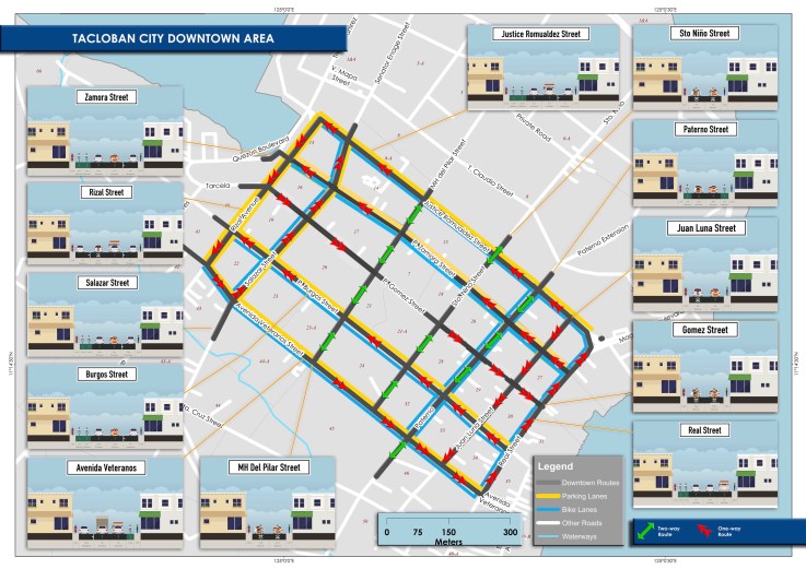
The scheme calls for a reduction in on-street parking; restricting such to one side of the street only and where applicable. That is, on-street parking is not allowed where there is already off-street parking along establishments, where there are driveways, and within one or two vehicle length from intersection corners. There will also be designated loading/unloading areas for public transport so parking is also prohibited there.
A couple of important features in the scheme are the enhancement of pedestrian facilities, particularly sidewalks, and the introduction of bicycle lanes. These are more clearly shown in the cross-section examples included in the map. Note that for other streets where there are no designated bike lanes indicated, it is assumed that lanes will be shared with motor vehicles. This is an application of the concept of shared right of way or “sharrow” as it is also termed. The scheme is contextualised along the lines of “people-oriented” transport rather than “car-oriented”, and hopefully would lead to a more walkable downtown area and encourage more people to use bicycles. This promotion of active transport should also lead to a healthier city. I will post about the transport plans prepared for the city in future articles here.
–
On child-friendly cities
Here’s another article that I want to share. This time it is about child-friendly cities. Here is an article that present many good practice examples in other cities. Many are easily replicable in our towns and cities, and should be considered by local governments in order to enhance safety and health aspects in their jurisdictions.
Laker, L. (2018) “What would the ultimate child-friendly city look like?”, theguardian.com, https://www.theguardian.com/cities/2018/feb/28/child-friendly-city-indoors-playing-healthy-sociable-outdoors [Last accessed 3/9/2018]
–
On prioritising pedestrians and promoting walking
We begin March with an excellent article that came out from curbed.com:
Walker, A. (2018) The case against sidewalks and how cities can create new avenues for pedestrians, curbed.com, https://www.curbed.com/2018/2/7/16980682/city-sidewalk-repair-future-walking-neighborhood [Last accessed 2/23/2018].
How do we improve the environment (i.e., facilities) to encourage people to walk? Do we simply clear up sidewalks? Widen them? Build overpasses and underpasses? What should be the context for improving pedestrian facilities for our cities and municipalities? What are the implications to planning and design?
–
Another walkability tool: Pedestrians First
The ITDP recently came out with a new walkability tool called Pedestrians First. Here’s the link to their site where you can download the tool. The tool was released in the recently concluded World Urban Forum held in Malaysia.
https://www.itdp.org/publication/walkability-tool/
Of course, there are other tools out there including one developed by Clean Air Asia, material on which may be found through the following links:
http://cleanairasia.org/walkability-study-in-asian-cities-4/
Our technical staff and my students are currently using the methodology developed by Clean Air Asia and have covered several major thoroughfares in Metro Manila and a highly urbanized city in studies that have been undertaken in the last 6 years. I already asked them to take a look at the new tool and see how this compares with the ones we are using.
–
Tacloban downtown in the early mornings
Mobilizing surveyors for traffic data collection in Tacloban City’s downtown, I took the opportunity to take some photos before 6:00AM. This was before most people were at work or school on the first good weather day in the city after a week of heavy rains that brought floods and landslides to parts of the city. Schools at all levels had been suspended earlier this week with government offices also closed last Monday.
 Zamora Street towards southeast and M.H. Del Pilar Street
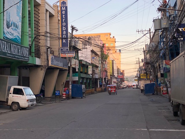 Zamora Street towards northwest and Salazar Street
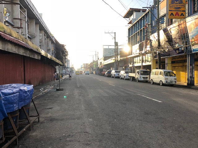 Justice Romualdez Street to southwest and M.H. Del Pilar Street
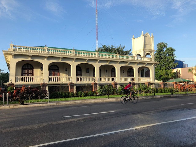 A lone cyclist along Justice Romualdez Street
There’s something about coming out to walk in the early morning in cities like Tacloban. You catch a city at a time before all the action happens, when everything seems so peaceful and calm when you see more people walking and cycling than motor vehicles dominating road space. That serenity should serve as an inspiration for what should be the vision for a city in order for it to retain its soul rather than lose it in what can be nightmarish traffic and transport conditions. Tacloban’s downtown holds so much promise for revitalisation but among the issues that need to be addressed is traffic-related. The city needs to recover spaces for pedestrians and cyclists while ensuring efficient traffic circulation for motor vehicles, particularly public transport. There seems to be spaces available for road diets and the creation of safe paths for people, and such design challenges need to be taken on in order to transform the downtown area into an example of sustainable transport.
–
The need for speed (limits)?
My social media newsfeed regularly contains updates being posted by various entities about transport and traffic in Metro Manila and across the Philippines. Among those I regularly see are posts on road safety and interesting to me are the frequent posts on legislating speed limits at the local level. These are in the form of city or municipal ordinances that are supposed to strengthen, supplement and/or clarify speed limits that are actually already stated in the road design guidelines of the Department of Public Works and Highways (DPWH). These limits apply not only to national roads but to local ones as well. However, their effectiveness may be limited or reduced by the absence or lack of signs, markings and, most importantly, traffic law enforcers who are supposed to monitor traffic and apprehend those violating rules and regulations.
While there is a need for defining and clarifying speed limits perhaps in the form of local legislation, I believe the more urgent matter is the implementation and enforcement of laws. It has often been mentioned that we already have so many laws, rules, regulations and the truth is we do, and may not need more. One really has to go back to the basics in terms of enforcing these laws and that means enforcers need the knowledge and tools to be effective in their work. There is an opinion that many enforcers are not knowledgeable about many rules and regulations and therefore are prone to just focus on a few including violations of the number coding scheme, truck bans and the much maligned “swerving”. You do not often seen apprehensions for beating the red light, beating the green light (yes, there is such a violation), speeding, or “counter-flowing” (or using the opposing lane to get ahead of traffic in the correct lanes). There are also turning violations as well as those involving vehicle (busted tail lights, busted headlights, busted signal lights, obscured license plates, etc.). More recently, there are anti-drunk-driving laws that also urgently need proper implementation.
I think the current work that includes sidewalk clearing operations and anti-illegal on street parking of the Metropolitan Manila Development Authority (MMDA) is one good example of going back to the basics. These address the necessity of clearing space for both pedestrians and vehicles; space that have been constrained by obstacles that should not be there in the first place but so often have gotten the blind eye treatment. Going to the “next level” though requires tools such as speed guns, high speed cameras at intersections, and instruments for measuring blood alcohol levels in the field (breath analyzers). And these require resources for acquisitions as well as capability building in the form of training personnel to handle equipment. No, I don’t think we need more laws, rules and regulations. What we urgently if not direly need is their proper implementation to effect behavior change that will improve both safety and the flow of traffic.
–
New guidelines for bikeways
I want to share an article discussing new guidelines for bikeways released in the US.
Andersen, M. (2017) “Which Bike Lanes Should Be Protected? New Guide Offers Specifics,” Streets Blog USA, https://usa.streetsblog.org/2017/11/01/which-bike-lanes-should-be-protected-new-guide-offers-specifics/ (Last accessed 11/16/2017)
This is useful not only for practitioners or planners but also for academic purposes such as in transportation planning or engineering courses where future planners and engineers are molded.
–
On “phone zombies” and road safety
You see a lot of people these days who are always on their smart phones. Many are walking while doing something with their phones whether making a call, typing away, listening to music or perhaps attending to social media. Many are not aware of what are happening around them and this puts them in a situation where that increases their vulnerability. There are those who cross streets without checking for oncoming traffic. There are those walking along the roadside who are not mindful of the likelihood of being sideswiped by vehicles. As such, there is a need to address this behavioral concern to reduce the occurrence of incidents that could lead to deaths if not injuries.
There is a nice article I read recently about an initiative in the Netherlands where they installed pavement traffic lights:
Scott, G.L. (2017) “Dutch City Installs Pavement Traffic Lights to Help ‘Phone Zombies’,” Inverse, https://www.inverse.com/article/38472-dutch-city-installs-pavement-traffic-lights-to-help-phone-zombies?utm_source=newsletter&utm_medium=culture&utm_campaign=photo, (Last accessed 11/19/2017).
The assessment for this initiative is quite limited – one day as mentioned in the article – but is promising especially from the perspective of innovation. We need such innovative thinking in order to address the issues about safety. This is but one example of many aimed at curbing road crashes that lead to injuries and deaths particularly with respect to the most vulnerable among us.
–

