
Home » Pedestrian (Page 12)
Category Archives: Pedestrian
Ortigas Center walkways under construction
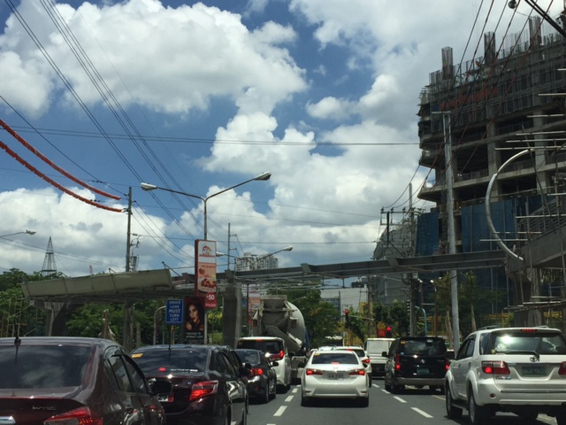
Currently under construction at the Ortigas Center are elevated walkways that are part of the Ortigas Greenways Project. Following are some photos I took a few weeks back (they’re old!), and so the current state should show significant progress from what is in the photos.
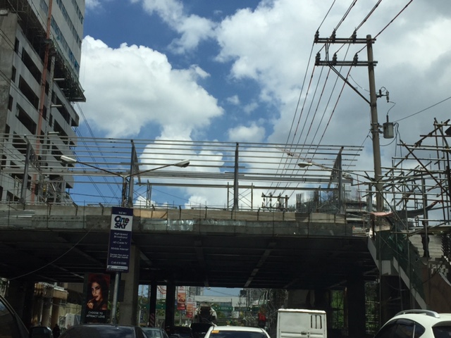
 Elevated walkways are currently under construction at the Ortigas Center. This part can be seen along Julia Vargas Ave. at the intersection with Garnet St.
 Structure at F. Ortigas, Jr.
 Close-up of the F. Ortigas part of the elevated walkways
 Walkway section under construction along the approach of ADB Ave./San Miguel Ave.
 Crossing under construction at the intersection of Julia Vargas with San Miguel Ave. (to the left) and ADB Ave. (to the right).

 View of the F. Ortigas crossing walkway along the eastbound direction of Julia Vargas Ave.
This project is perhaps one of the most hyped pedestrian facilities in Metro Manila and if I recall right, the concept for this can be traced to workshops conducted during one of the Transport Forums organized by the Asian Development Bank (ADB), whose headquarters are located in Ortigas Center. It took a while to be realized but should be completed soon. This won’t be the first of its kind in Metro Manila as Makati already has one connecting office and residential buildings to Greenbelt and Glorietta. I really do hope it is able to reduce congestion in the area but this would require studies after the facilities are opened for public use. We need more of these around Metro Manila as well as other major cities. We direly need facilities to encourage walking as a preferred mode over motorized transport.
–
Challenges for students commuting to/from schools
Its our first day of school for our daughter today. But unlike her, I recall that I had to wake up early when I was in grade school and high school because the ‘service’ providing transport to and from school had to pick me up and then others. That usually meant a 5:30 AM wake up, a quick shower, dress-up (we wore uniforms) and breakfast before the ‘service’, an AUV, picked me up at home. School started at 7:30 AM and it took something like 45 minutes (depending on traffic) from our last pick-up to get to school at exactly 7:30. If our vehicle is able to finish pick-ups earlier, that meant we were assured of not being late for homeroom period. If the other kids (and there are many) are running late and we end up waiting longer for each, then we would likely be late. In many cases, our driver would have to resort to being reckless in order to make the time.
Nowadays, I think its much more difficult for kids due to the worsening traffic congestion. What was a 30 to 45-minute travel time between our home in Cainta to Pasig/Mandaluyong is now easily twice or longer that. And I am only referring to a direct trip. Even with Waze available, one can only have few options for routes between home and school.
While there are still many school ‘service’ vehicles (and not so many actually buses), many parents seem to have opted to Ateneo, for example, used to have a fleet of buses transporting students. These were replaced by AUVs and vans accredited by the school, and the many (too many?) private vehicles ferrying mostly individual students to and from their Quezon City campus.
 School children have to wake up early to go to school. Some probably take their breakfasts as baon in order to save time for traveling. Some take their breakfasts at nearby eateries or fast-food restaurants.
 Many children may be at risk as they are ferried to school via motorcycles and usually without helmets. In other cases, there are tricycles acting as school service vehicles. Often these are overloaded with children and their school bags.
Pedestrian facilities are also lacking in many cases and particularly in rural areas where public schools are located along highways that have no sidewalks or cities where pedestrian walkways are not built to standards for one reason or another. These are issues that need to be addressed and would be nice topics for research, especially those with practical and safety applications.
–
Some articles on walking, biking and transit for wellness
Here are a couple of recent articles on walking, biking and transit:
Walk, bike, and transit benefits boost people of all incomes [McAnaney, P. in Greater Greater Washington, June 13, 2017]
“Bikes are happiness machines.” Behind the Handlebars with cyclist extraordinaire Joe Flood [Maisler, R. in Greater Greater Washington, June 7, 2017]
I posted these partly for future reference but also to promote walking, biking and public transport. These are essential elements for mobility anywhere and governments should ensure that people have these as options for traveling about and not be dependent on automobiles for transport.
–
Back to school – concerns about congestion and safety
Many roads again are expected to become more congested as school resumes in most parts of the country especially in cities. But while congestion is usually the top issue along roads near many schools, one concern that usually takes a back seat to congestion is safety. Many public schools in the provinces are located along national highways. Many if not most of their students walk to and from school, usually on the carriageway when the shoulders are too rough, dusty or muddy. This situation for students increase the likelihood of their being hit by vehicles using the road. The risk increases because of their exposure to the dangers posed by motor vehicles. Following are a couple of photos showing typical cases at public schools along national roads. Both are in Antipolo City.
 Typical at-grade pedestrian crossing in front of a school. Students in most public schools often commute by walking or taking public transport like jeepneys or tricycles.
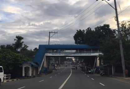 Despite this pedestrian overpass across a public school along Sumulong Highway, most students still prefer to cross on the road rather than go up and down the overpass.
Oftentimes, the seemingly obvious solution of constructing overpasses for safer crossings for students does not pan out as planned or intended. There are many underutilized pedestrian bridges since the natural way is still to cross at-grade. Then there is the issue of providing them safer walking paths or walkways. In both photos above, the sidewalks are only token (“puwede na iyan”) and insufficient for the pedestrian traffic supposed to use them. We need to plan, design and provide such facilities for our pedestrians, especially children, who are marginalized compared to those who have their own vehicles for travel.
–
On walking and the old pedestrian overpass at UPIS
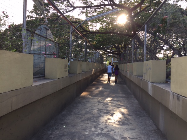
I decided to go for a long walk one day last April. I walked from our office to the UP Town Center, which was just under 2 kilometers away, to purchase something. I could have taken my car or perhaps rode a jeepney but I wanted to see for myself how easy or difficult it was to walk that distance. It turned out that it wasn’t a difficult walk at all. From Melchor Hall, I crossed the street so that I could walk along the inner part of the Academic Oval. I then took a short cut through the trail in front of Malcolm Hall at the edges of the Sunken Garden, emerging just near the grandstand. From there, I crossed towards Vinzons Hall and then walked towards and along Shuster Street near UP Integrated School. I exited the campus at the portal at the end of Shuster and crossed Katipunan using the old pedestrian overpass that connected the main campus with what used to be UPIS on the other side of C-5.
 The pedestrian overpass is an old structure compared to many of its kind around Metro Manila. The design is quite massive considering it is a concrete structure. The photo above was taken towards the direction of UP Town Center.
 The steps are quite steep on either side of the overpass
 Here’s a photo of a person carefully walking down the steps of the overpass.
 The photo above was taken towards the direction of the UP campus.
The overpass used to be dirty, unkempt, and to many was revolting enough that it was rare to find people using it to cross Katipunan. Most people crossed the busy thoroughfare on the ground, often braving the traffic and taking on the risk of getting hit by a vehicle. Since the overpass was integrated with the UP Town Center (i.e., it is physically connected to the mall and there security personnel posted there), more people now use it. MMDA also fenced much of the median of Katipunan in the area and so the only way to cross the stretch of UP Town Center from Shuster to C.P. Garcia is via either of the two pedestrian overpasses (there’s a second, newer steel structure near C.P. Garcia).
As for the walk to Town Center and back, I thought it was safe, convenient and invigorating (nothing like some walking to help in blood circulation). I took a leisurely pace (not brisk) for my walk so I could enjoy the environment. You tend to see a lot of things when you take such walks and the campus is full of activities, sights and sounds, to help make the walk enjoyable such that you won’t even notice the time and perhaps, won’t even mind the exercise.
–
Vermont Royale pedestrian overpass
There was a comment on a previous article asking if the pedestrian overpass across Vermont Royale along Marcos Highway is already usable. The photo in that article showed a still-to-be modified overpass. Following are photos taken last Sunday of the overpass. It shows the lowered mid-section passing under the Line 2 extension structure.
 The modified pedestrian overpass across Vermont Royale along Marcos Highway
 That’s a pedestrian and a cyclist using the overpass
–
The Tagaytay transportation predicament
The title of this article is actually a bit tame and on the diplomatic side of trying to describe transportation and traffic in this city that was once relaxed a retreat for many. I had wanted to end February on a good note and so I decided to defer posting this until March.
We used to frequent Tagaytay and liked spending some rest and recreation time there to the tune of being there almost once a month at one time. Needless to say, at the time travel to Tagaytay from our home in Antipolo took us only about 2 to 2.5 hours excluding our usual stop at Paseo in Sta. Rosa, Laguna. We liked the city so much that we even considered making it a second home; even inquiring and looking at properties there.
Fast forward to the present and it has become an excruciating travel with the highways leading to the city already congested. It didn’t help that when you got there, you also had to deal with serious traffic congestion. This started not a few years ago when the city approved developments by major players including Robinsons, SM and Ayala. The developments by SM and Ayala proved to be the backbreakers with Ayala coming up with the first mall in the city and SM operating an amusement park beside its prime acquisition that is the Taal Vista Hotel. Now, there is another mall under construction by Filinvest and right at the corner of the rotonda where the Aguinaldo Highway terminates.
 Vehicles queue along the Tagaytay – Nasugbu Highway towards the Rotonda where Tagaytay traffic enforcers attempt to manage traffic but appear to create more congestion instead.
More on Tagaytay soon…
–
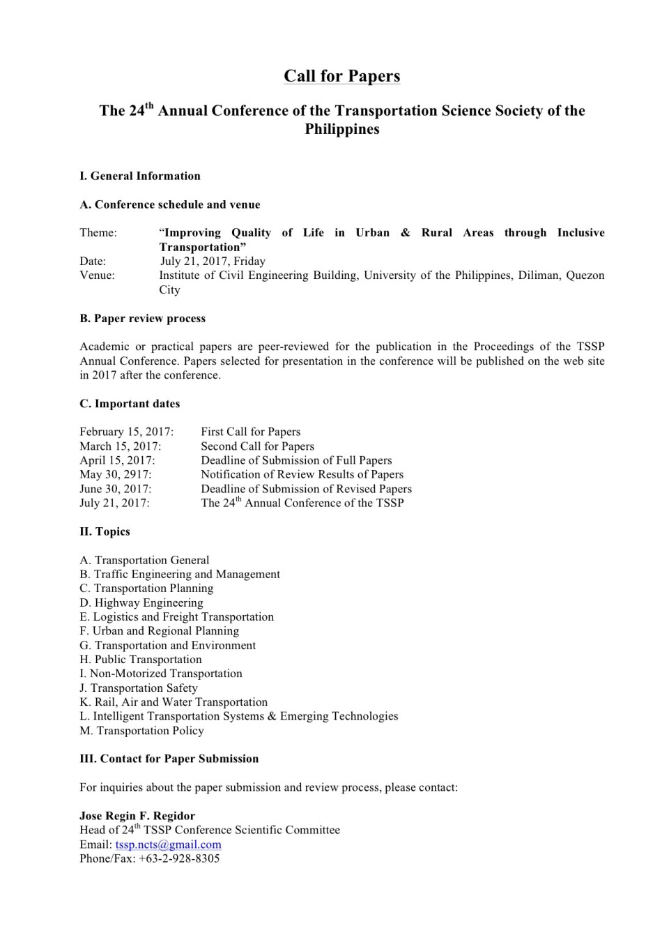
First call for papers for the TSSP 2017 conference
The first call for papers for the 24th Annual Conference of the Transportation Science Society of the Philippines came out last Wednesday, Feb. 15:
–
Commuting and stress
Here is another quick post but on a topic that’s related to health and therefore is something that I think many should be interested in and perhaps take important note of.
Commuting: “The Stress that Doesn’t Pay”
There are many links to various medical articles within the article. At the last part, there is also a list of references that the reader may want to look at. I’m also posting this for future reference. This would contribute to the formulation of topics for research especially the inter-disciplinary or collaborative kind.
–
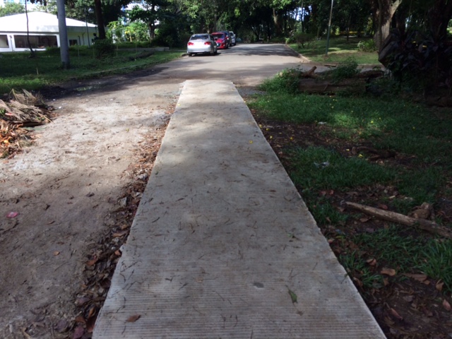
Footpaths at the College of Engineering Complex, UP Diliman
There are newly constructed concrete footpaths connecting the buildings of the College of Engineering complex at the University of the Philippines Diliman. These are intended for pedestrians to be able to walk between buildings without worrying about weather-related concerns such as muddy paths during the wet season.
My colleague took the following photos while walking towards the Institute of Civil Engineering building from Velasquez Street where the university has a portal leading to its housing for faculty and staff.
 The concrete pathway is a significant improvement from the old dirt path that seemed to have been carved out of people’s trekking along this path over the last year or so.
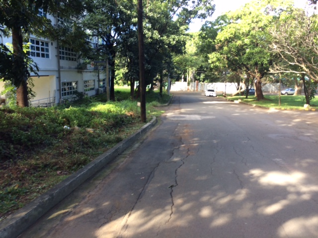
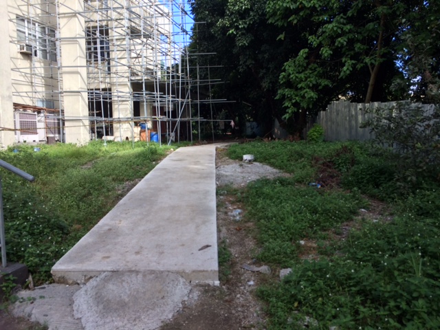 The path connects buildings at the area designated for the College of Engineering Complex. Many buildings such as the one above are under construction or to be constructed in this area.
 Much of the pathway goes through trees and other plants, preserving the greens already there that help provide a more enjoyable environment for walking.
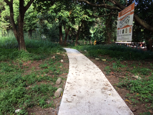 The pathway was dubbed the “Engineering Unity Path” as it connects buildings that are homes to individual institutes and departments that constitute the College of Engineering.
 End of the road – one end of the foot path leads to Maramag Street and the driveway to the Executive House, the official residence of the UP President.
 Maramag St. towards the Institute of Civil Engineering (ICE) complex with the ICE main building at left
While the pathway seems to be a permanent structure it is something I think is basically evolving just like the College of Engineering Complex. The complex already has a master plan but implementation towards a cohesive complex seem far from completion. For one, much of the complex covers a residential area in the university that has many (too many) informal settlers. And then there is the Executive House at the heart of the complex that probably needs to be moved elsewhere.
–
