
Home » Policy (Page 44)
Category Archives: Policy
Urban Transport Study in Manila Metropolitan Area (UTSMMA, 1973)
[Important note: I have noticed that the material on this blog site has been used by certain people to further misinformation including revisionism to credit the Marcos dictatorship and put the blame on subsequent administrations (not that these also had failures of their own). This and other posts on past projects present the facts about the projects and contain minimal opinions, if any on the politics or political economy at the time and afterwards. Do your research and refrain from using the material on this page and others to promote misinformation. I suggest you go to the The Mass Transit System in Metro Manila site for more facts about railway development and history. I do not consent to the use of my articles for the purposes of misinformation and historical revisionism. 10/13/2019]
With the recent approval of JICA’s Dream Plan for Mega Manila, I thought it was timely to look back at similar plans developed for Metro Manila and its surrounding areas. At the time these plans were made, I guess they were all regarded as “dream plans” in their own ways. Let us start with what is probably the original dream plan, the Urban Transport Study in Manila Metropolitan Area (UTSMMA, 1973). The project was implemented from March 1971 to September 1973 with the assistance of the Government of Japan’s Overseas Technical Cooperation Agency (OTCA), the precursor of today’s Japan International Cooperation Agency (JICA). Being the first comprehensive study for a metropolitan area that was yet to be formally consolidated and called Metro Manila, UTSMMA set the stage for future transport studies for the metropolis. Among the study’s main recommendations is one proposing for a mass transit system restricted to railways. A Rapid Transit Railway (RTR) network was recommended in the form of subways in the inner area bound by EDSA, and elevated in the suburban areas. Brief descriptions of the proposed lines are as follows:
- Line 1 (27.1 km) – from Construction Hill to Talon via central Quezon Boulevard, Manila downtown and the International Airport
- Line 2 (36.0 km) – from Novaliches to Cainta via Manila downtown and Pasig
- Line 3 (24.3 km) – Along Highway 54 (C-4): half a circle route about 12 km from Manila downtown
- Line 4 (30.1 km) – From Marikina to Zapote via Cubao, Manila downtown and the Manila Bay area
- Line 5 (17.6 km) – From Meycauayan to Manila downtown running between Line No. 2 and PNR
- PNR improvement (56.4 km) – From Bocaue to Muntinglupa via Tutuban Station
The following that was posted here before in another article shows a map illustrating the recommended RTR network for the Manila Metropolitan area. (Note that the map was enhanced from the original black and white to clearly show the proposed lines back then.)  UTSMMA also recognized the important roles of buses and jeepneys in the future, and recommended that these be used for feeder services once the rail systems have been constructed and operational. As a result of the study, a Feasibility Study for the Manila Rapid Transit Railway Line No. 1 was conducted and completed in June 1976. The study, which was supported by JICA, noted that “the implementation should be initiated immediately” in light of the estimated heavy traffic demand along the corridor. This project could have been the first major transport project for Metro Manila if it had been implemented. Unfortunately, despite a favorable assessment in this study, the proposed RTR Line 1 was not implemented after a contrary assessment by a subsequent study, MMETROPLAN, which is discussed in the succeeding section of this report. The estimated costs of construction of recommended transport infrastructure were provided in the Final Report of the study including indicative costs and benefits of proposed urban expressways and urban rapid transit railways. [Reference: UTSMMA, 1973 – NCTS Library] Whenever I go back to UTSMMA and the network of proposed railway lines, I can’t help but wonder what could have been one of the more efficient transport systems in Asia or even in the world. What happened? Why was this plan not realised? The answer may be found in the next big study conducted for Metro Manila that also included in much detail its land use and development plans. Next: MMETROPLAN, 1977 –
EDSA: Taft to Tramo
The EDSA-Taft Ave. intersection was in the news a few weeks ago due to the MRT3 train that derailed and overshot the end of the line along EDSA. Being a major intersection for roads as well as for rail (MRT3 and LRT1), it is a very crowded area. Nearby, too, is the Redemptorist church in Baclaran that attracts a lot of people especially during Wednesdays. Following are a few photos of the area showing the conditions on the pedestrian overpasses and at street level.
 The pedestrian overpass at EDSA-Taft is also a mall of sorts given the merchandise being sold at informal shops at the overpass.
 The overpass connects to the EDSA-MRT 3 Taft Ave. Station. This is the MRT 3’s end station and the overpass system connects the MRT 3 Taft Ave. Station with the LRT Line 1 EDSA Station. The connection was not and is still not a smooth one, which has been the subject of criticism from a lot of people.
 The overpass allows people to walk around this large intersection
 Pedicabs freely travel along this stretch of EDSA between Taft and Tramo on lanes designated for public utility buses and clearly violating regulations regarding what vehicles are allowed on EDSA. You can also see in the photo a cart full of merchandise being pushed along the curbside lane.
 A motor tricycle ferrying passengers along EDSA just before Tramo (that’s the street above which is an overpass from EDSA southbound).
–
2014 Professorial Chair lectures on transport topics
The 2014 Professorial Chair Colloquium of UP Diliman’s College of Engineering was held from yesterday until today. Most of the lectures concerning transport were presented today. Here are some of the highlights of the lectures delivered this morning:
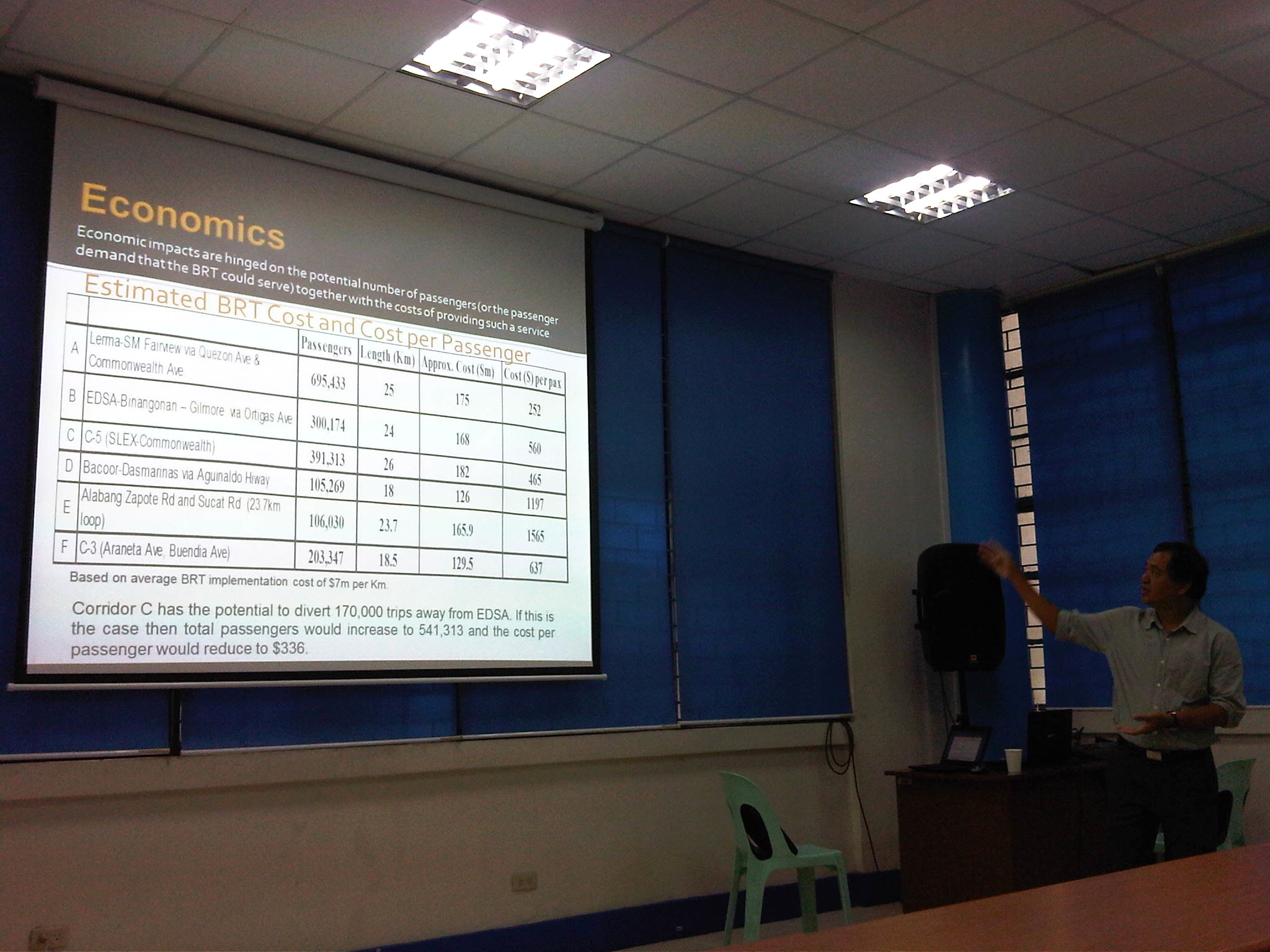 Dr. Ric Sigua, Director of the Institute of Civil Engineering, making a point about the economics of Bus Rapid Transit (BRT).
 Dr. Sean Palmiano, Director of the National Center for Transportation Studies, explaining the finer points of traffic impact assessment for high density residential developments.
 Prof. Happy Denoga of the Department of Mechanical Engineering explaining on the advantages of hybrid systems for vehicles.
 Dr. Karl Vergel of the Institute of Civil Engineering talking about the on-road tests for jeepneys using B5 or 5% CME-blended fuels in a project commissioned by the Philippine Coconut Authority.
 Comparison of jeepney mileage using 2% and 5% blended fuels.
 Dr. Edwin Quiros of the Department of Mechanical Engineering’s Vehicle Research and Testing Laboratory (VRTL) discussing the dynamometer tests conducted for jeepneys using B5 fuel.
There were other presentations but unfortunately, I wasn’t able to attend these as lectures were spread among various venues at the college. That’s often the hang-up of having parallel sessions during these colloquiums. Nevertheless, it is nice to know that transport remains a popular subject for these lectures.
–
On logistics in the Philippines
I am not a logistics expert and will not pretend to be one. I have, however, been involved in several projects that included logistics as a major study component. These include a nationwide study on inter-regional passenger and freight flow and another for freight forwarders affected by vehicle restraint policies in Metro Manila. A more recent engagement has allowed me to take a look at logistics in the country from other perspectives including that of national agencies seeking to improve goods movement in the country and development agencies that have committed to help the country to do just that. There are local issues and there are regional ones. The regional ones often involve the need for infrastructure such as maritime ports and airports, highways and bridges, and other facilities such as those for storage and refrigeration.
For an archipelago like the Philippines, logistics is a bit more challenging than in countries whose territories are not separated by bodies of water. There is no lack for good practices though as there are other archipelagos that could provide good examples for connecting the islands such as Japan and the United Kingdom. Nearby, we share similar challenges with Indonesia and to a certain extent Malaysia. Of course, availability of resources is always an issue and particularly for the prioritization of infrastructure to be constructed aside from those that need to be maintained. The DOTC along with its attached agencies like the Philippine Ports Authority (PPA) and the Civil Aviation Authority of the Philippines (CAAP) are in the frontline when it comes to airports and ports planning, development, and maintenance are concerned. However, the DPWH plays a vital role for highways and bridges and the connections for these ports and airports including what is termed as “last-mile” connectivity that is often passed on as a responsibility of local governments. This is likely due to local roads often providing the connection between national roads (under the DPWH) and ports and airports. It is a good thing that the current DPWH has committed to a convergence program regarding national and local roads that has benefited a lot of sectors and industries like tourism and agriculture.
Rail transport is not mentioned here because there is practically none even for what remains of the once relatively extensive PNR main lines. The local issues are not simpler and can be a bit more complicated than the regional ones. The complications are usually due to more petty circumstances that may involve politics and local power plays. The basic ingredients though are related to traffic congestion and the damage to roads and bridges attributed to trucks.
Many cities and municipalities have implemented truck bans along their major roads. These are usually one or two routes in the smaller cities and towns, usually passing through the “bayan,” “poblacion” or central business district (CBD). These roads are usually national roads (e.g., McArthur Highway and the Pan Philippine Highway pass through many towns). As such, there are cases where bypass roads are constructed to alleviate congestion along these roads as well as to try to preserve the pavements in the town proper. Such traffic schemes targeting heavy vehicles are not new and are also a way to address the issue on overloading that is common in trucking in the Philippines. The bypass roads, however, generally invite development and unplanned development have often made these alternate routes more congested than the original ones.
Manila did a “power play” recently by implementing a more aggressive truck ban. This led to more severe congestion around the Port of Manila and a lot of delays that have cost a lot of money in part due to the limited alternative routes in the city and most roads are already constricted. The costs have repercussions on the economy in general as the movement of goods are affected by the impasse in Manila. Whether this was for more political or practical reasons is difficult to say because the mayor and vice mayor have invoked the very common issues of traffic congestion, road safety and pavement maintenance that got the attention, sentiment and agreement of a lot of people. Many of these people though do not understand the impacts of inefficient goods movement and likely are concerned only about passenger transportation.
More recently, a lot of containers were shipped from the Port of Manila to Subic. These are supposedly “overstaying” shipments or those that have not been claimed for a long time or have some issues regarding their release. This should ease congestion somehow but there remain the problems of shipping or logistics companies regarding freight transport in general that needs to be addressed. Both Subic and Batangas ports have been mentioned in many formal studies over the past few years including a more recent one supported by JICA. Still, there is a lot of hesitation if not confusion or uncertainty on how to go about with shifting goods movement to these ports, which are regarded to be underutilized. There are good roads connecting these ports with cities and towns but these might not be enough in the long run.
Perhaps there is a need to reconsider regional rail transport again especially for the islands of Luzon and Mindanao where long distance rail may have a tremendous impact for transporting goods over long distances. Of course, there are also issues pertaining to other ports and airports in the country including those in Mindanao (e.g., Davao, Cagayan de Oro, Phividec, Gen. Santos, etc.) and Visayas (e.g., Cebu, Iloilo, Tacloban, etc.). The RORO ports are among those that need attention as they are directly involve road transport aside from the ferries that carry them over the waters. These nautical highways are vital for goods movement around the country and require both national agencies and local governments cooperating for these facilities and services to function efficiently.
–
Sound opinions on transport and traffic
One of my favorite reads is the column by former NEDA Director General Cielito Habito on the Philippine Daily Inquirer (Inquirer.net). Regardless of whether he is writing about transport or any other topic, his articles are consistently clear and logical. Here are a couple of articles from his column “No Free Lunch” about the more recent transport and traffic issues.
Traffic dilemmas – which appeared August 12, 2014
More railways in our future – which appeared August 19, 2014
I’m not sure if those in-charge or responsible for planning and building our transportation system read his columns. They will learn a lot from these articles especially as the former NEDA DG is practically sharing his experience and wisdom – things badly needed these days especially at the DOTC.
–
Proof of concept
I recall a quote from the cold war era when Nikita Kruschev was supposed to have asked “how many divisions did the Pope had under his command?” This was basically a challenge to the Pope after the latter made some statements regarding the Soviet Union and its military action in Eastern Europe and elsewhere. A similar challenge could be made, albeit vastly reworded, for many advocates of various transport programs and projects to prove they had the numbers or the proof to support their calls for certain projects or programs to be implemented. Often, the proof comes in the form of examples or demonstrations of their proposals. Simplest perhaps would be to present examples of best or good practices in other countries (e.g., bicycle paths in Europe, transit in Singapore, walkways in Japan, etc.).
One that is still fresh in my mind is what has been said to be the “challenge” of Malacanan to the DOTC to present a “proof of concept” for BRT as a pre-requisite of the proposed project in Cebu to be approved. This “challenge” boggled the minds of many experts and advocates of public transportation as BRT is well established around the world and there are many cities with BRT systems worth emulating (To be accurate, there have also been failures but these were mainly due to compromises made that led to the systems not adhering to essential BRT requirements.). What’s stranger was the response from DOTC to do a demonstration via an experiment at Bonifacio Global City to simulate BRT operations. Obviously, this experiment could not be a really good approximation of BRT (something along Commonwealth would have been more suitable) given the conditions at the Fort.
With the recent approval of the Cebu BRT project, we now look forward to its construction and operation. I am aware of how much work was put into the non-technical aspects of this project (i.e., social and institutional) and so a lot of eyes will be on changes to Cebu City’s transport system once the BRT becomes operational and the expected rationalisation of the existing public transport routes and vehicles would take place. There will definitely be a transition period and it is not known how long this will be or how much opposition the change will encounter. Doing workshops and consultations, and getting commitments here and there is one thing. Having the BRT operational and actually affecting the operations (and revenues) of conventional road transport is another matter.
Many cities will look to Cebu’s experience and probably emulate it should the BRT be a success. Metro Manila is too complicated for other cities to identify with unlike Cebu, which likely has similar transport and traffic issues to cities like, for example, Iloilo, Bacolod, Cagayan De Oro or Legazpi. Of course, there will be exceptions and unique problems for each but density-wise, Cebu compares well with more cities in the country than Metro Manila. Here’s hoping that the BRT would finally have its true and actual “proof of concept” in Cebu and that this can demonstrate the benefits of such a system to other Philippine cities along with a necessary rationalisation of existing public transport modes.
–
Airport taxi at NAIA?
I have been hearing and reading a lot about horrible experiences of various people including friends on airport taxis. All the stories seem to be about getting a taxi at NAIA where airport management has “accredited” one or a few companies to provide airport taxi services. This exclusiveness has clearly become disadvantageous to many passengers who have not previously arranged for someone to pick them up at the airport (e.g., a relative, a friend, his/her company vehicle, or maybe transport service from the hotel where they will be staying). The coupon taxi services, however, is usually the safer bet for those unfamiliar with Metro Manila as regular meter taxis often “prey” on travellers who are not knowledgeable about fares and traffic conditions. Often, one would have to negotiate for fares though there are honest cab drivers who would do their jobs without haggling or demanding for tips.
Allow me to cite a number of examples in international airport terminals abroad and in other Philippine cities where getting a taxi at the airport is relatively straightforward and stress-free:
1. In Singapore’s Changi Airport, you can easily get a cab at any of the terminals. You just get into the queue (if there is any) and get the next available taxi. The drivers do not discriminate among potential passengers and the only question asked is about the destination of the passenger. Sometimes, the driver will ask about a passenger’s preferred route as there are toll roads between Changi and the destination. There are bus and rail services connecting the airport to the rest of the city-state and many passengers also choose these options.
2. In Bangkok’s Suvarnabhumi Airport, you can also get a taxi at the queue at the basement level. There are airport taxi counters at the lobby as passengers come out of the arrivals but these are the more “exclusive” companies and charge more per vehicle. However, if you are a group comprised of at least 4 people, then it would be cost effective to engage these companies as they can provide a larger vehicle (e.g., van) that can be more comfortable than a regular taxi. This is particularly recommended for people who have a lot of luggage like families. Otherwise, you can take a regular cab at the basement level queue. These are metered taxi but some may negotiate a fixed (and therefore higher) rate. Transfer to another if you don’t agree with the driver.
3. In Cebu’s Mactan Airport, the taxi bay is a just a few minutes walk from the arrival area. There is a queue and a security guard issues a ticket with information on the taxi (license plate number and company) that he gives to the passengers as reference should there be complaints on the driver as well as in cases where some belongings are left in the taxi.
4. In Iloilo, there are many taxis to choose from once you get out of the airport terminal. There are many taxi service counters just outside the arrival area and passengers can engage any of these companies for a ride to the city or other destinations. My Ilonggo friends will definitely recommend Light of Glory as their taxi company of choice. This company is highly regarded for their quality of service that includes honesty among its drivers. You can also contact them to make arrangements for transport between your hotel/accommodations and the airport.
5. In Davao, there is a regular taxis queue just outside the terminal building and the city has a transport enforcement unit that is stricter than most LGUs. This ensures that taxis will likely comply with traffic rules and regulations including the safe conveyance of passengers to/from the airport. These are metered taxis though there will always be taxi drivers who will attempt to negotiate fares or tips with the passengers. This will not be done at the airport as airport or city staff will be on watch at the terminal. Instead, the negotiations are done once the passenger is inside the taxi and leaving the airport.
Of course, in the international airports I mentioned, there is the option of taking the airport express train instead of taking a cab. Both Changi and Suvarnabhumi, for example, have excellent rail connections, and more experienced travelers would probably take these train services over taxis as they are less expensive and allow for shorter travel times (i.e., taxis can be caught in congested roads especially during peak periods).
NAIA desperately needs good options for public transport such as airport limousines or more dependable taxi services. Sadly, getting a taxi in Metro Manila is basically a “hit or miss” affair. There is a 50/50 chance that you will get a good taxi driver so there is an equal chance that you will get a bad one. At the airport, there might be a higher likelihood that one can get a bad taxi if we assume that taxi drivers might be deliberately taking advantage of potential passengers who are not familiar with Metro Manila and its taxis. As mentioned earlier, more experienced travellers would likely have pre-arranged transport between the airport and their destinations. So the coupon taxis would have to do for now and until there are better options for transport including more reliable regular metered taxi services.
–
Practicable road sharing in Antipolo
As there are increased calls for more bikeways, we try to look at some good examples of what I’d call “practicable” road sharing. I term it “practicable” because it is something doable or is already being done or practiced. I tried to find a few good examples of practicable road sharing to show that it can be done and usually if all road users respect each others’ right to use the road. This respect can be developed over time and requires some familiarity for each users behaviors. Of course, there will always be abusive or disrespectful people on the road including drivers of different types of vehicles. Reckless or unsafe driving is not limited to public transport or truck drivers. There are also many unruly private vehicle drivers who endanger the lives of others whenever they are on the road. Then there are the motorcyclists, cyclists and pedestrians – all road users and also with bad apples or “pasaway” among them.
Road sharing happens everyday in Antipolo City in the Province of Rizal. Along Ortigas Avenue and Sumulong Highway – the two main routes to and from Antipolo, you will see motor vehicles, bicycles and pedestrians sharing what are mostly 4 lane, undivided sections of the two major roads. Antipolo is a very popular destination for cyclists so even during weekdays you will find a lot of people cycling up and down the mountain roads even during the night time and very early mornings. While many are recreational riders, many, too, are doing this for health. I would bet that a good percentage might be biking to work or school but there are no hard statistics to show this (topic for research?).
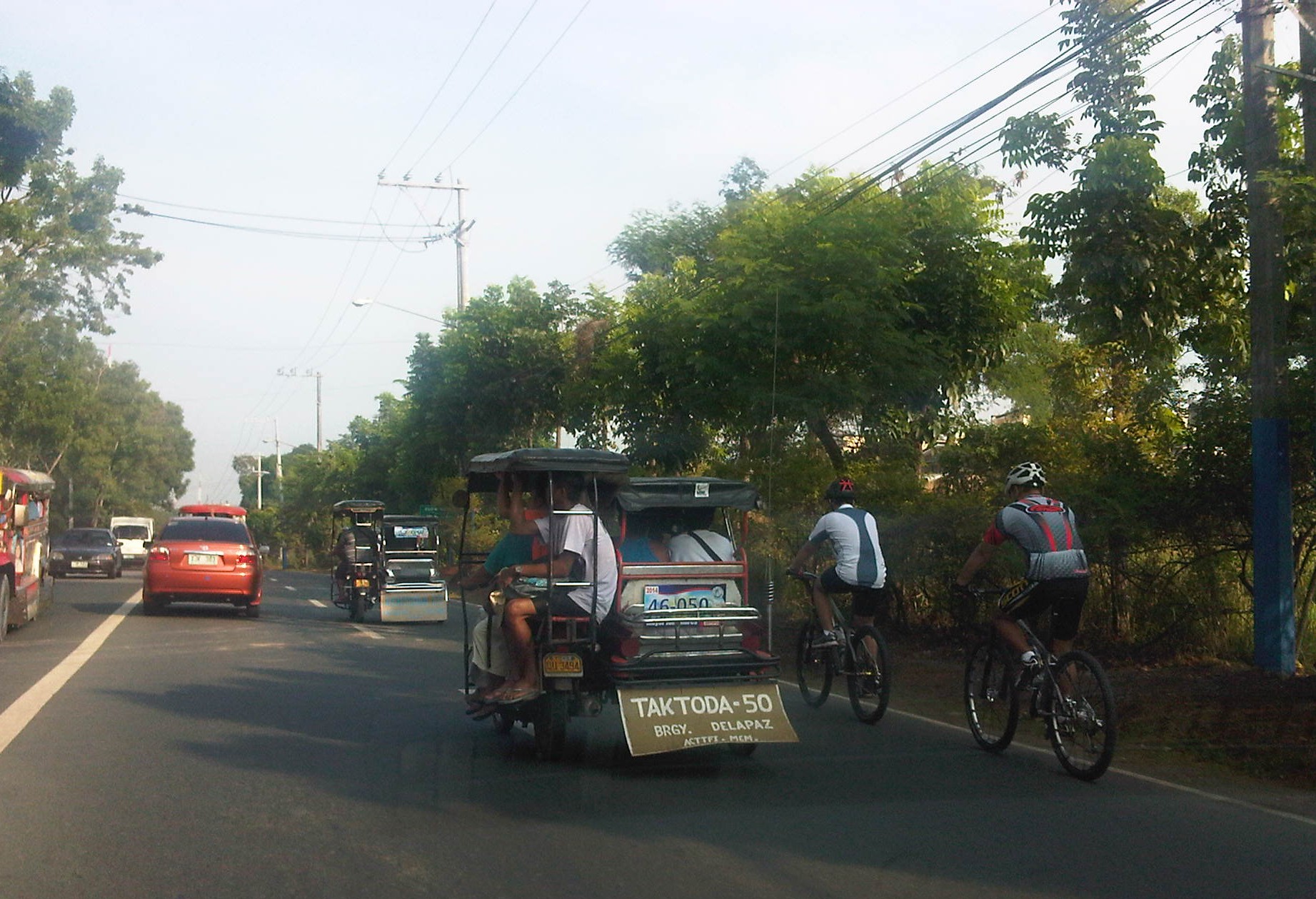 Motorists and cyclists “sharing the road” along Sumulong Highway
Sharing the road shouldn’t be too difficult. However, road users need to have respect for each other’s right to use the road. I have observed many instances where one or more road user types are guilty of “disrespect” and tend to hog the road as if making a statement that “i am king of the road” rather than “i have the right to use the road.” Here are among my pet peeves:
1. Slow moving trucks or jeepneys hogging two lanes and not giving way to other vehicles to pass them.
2. Jeepneys and private vehicles racing up or down the mountain roads and overtaking even in perilous sections (i.e., those already identified as prone to crashes).
3. Tricycles taking up the middle lanes and maneuvering anywhere.
4. Cyclists taking up the middle lanes or sometimes the entire two lanes of any direction preventing other road users to pass them.
5. People crossing anywhere along the road especially at blind sections (curves) where sight distance is limited.
There are practically no pedestrian sidewalks along most of Ortigas Extension and Sumulong Highway so pedestrians would have use the carriageway. As there are a significant number of people walking (e.g., students, workers, and even joggers or walkers), motorists and cyclists need to be careful not to hit these people. The same people, however, need to be aware of these vehicles and should exercise caution, always being alert as they use the road properly. Ultimately though, I would like to see walkways built along Ortigas and Sumulong especially since there is already an increasing demand for walking especially during the summer months when Antipolo holds its fiesta and a lot of people go on pilgrimages on foot to the Shrine of Our Lady of Peace and Good Voyage.
There is practicable road sharing in Antipolo because most road users are already familiar with each others’ behavior and accept each others’ presence and rights on the road. These road users are likely residents of Antipolo or nearby towns or regular visitors to the city. They are “nagbibigayan sa daan.” The “pasaway” people are likely the newer ones who seem to think that the way they drive or ride (i.e., unsafe) elsewhere is the norm. Of course, that goes without saying that familiarity with the roads and its users also breed risk takers who think they already know the road and have the skill and experience to drive like crazy. Here is where effective enforcement (e.g., timely apprehensions and reminders) and engineering (e.g., traffic signs and pavement markings) comes in to address the gaps in safety in order to reduce if not totally eliminate crash incidence along these roads.
–
What’s causing traffic congestion along Katipunan?
An article came out today on a popular online news site stating that the Metropolitan Manila Development Authority (MMDA) blames the Land Transportation Franchising and Regulatory Board (LTFRB) for the severe traffic congestion that is experienced daily along Katipunan Avenue (part of Circumferential Road 5). The article may be found in the following link:
MMDA: LTFRB to blame for Katipunan traffic
Reading the article, I would like to think that the MMDA likely misunderstood the advisory from the LTFRB extending the “non-apprehension policy” for trucks that have not renewed their franchises. This policy is not the same as the truck ban scheme being implemented in Metro Manila by the MMDA and LGUs. The trucks using Katipunan Avenue during the prescribed period that they are allowed travel along this and other roads are not violating any laws or regulations. Meanwhile, the increase in the volume of trucks can only be attributed to an increasing demand for goods that translate into freight movement. There are very limited alternatives to Katipunan Ave., which is a truck route (note: most of EDSA is not a truck route), and there are few wide roads that can accommodate the volume of trucks carried by C5.
I use Katipunan everyday as it is the main road between my home and my office. I can say that traffic has worsened along this stretch of C5 and one can always see the long queue of vehicles caught in traffic along the northbound side of Katipunan especially from the afternoon to night periods. There are many causes of traffic congestion along Katipunan Ave. and during times when trucks are banned from traveling, it is still congested due to the sheer number of private vehicles using the road. C5, after all, is a major road connecting Quezon City with Pasig, Makati and Taguig, which host major CBDs (Ortigas, Makati and Bonifacio Global City).
In the mornings, much private vehicle traffic is generated by the exclusive schools along Katipunan and the northbound side of the road is usually congested from C.P. Garcia all the way to Blue Ridge. Meanwhile the southbound side is full of vehicles from B. Gonzales (across Miriam College’s main gate) to Tandang Sora. In the afternoons and evenings, traffic congestion is caused mainly by traffic returning from Ortigas, Makati, BGC, etc. to Quezon City and elsewhere where their passengers reside. Road capacity is usually reduced by the parked and standing vehicles that usually occupy a couple or more lanes along Katipunan southbound.
I guess the MMDA would just have to do a better job of managing traffic along this corridor. However, they can only do so much given the sheer volume of private and freight traffic using Katipunan and the limited options for reducing traffic over the immediate to short terms. Only an efficient mass transit system (including walking and cycling for short trips) and a significant mode shift from private to public transport can provide a long term solution to traffic congestion along Katipunan. Until then, congestion along Katipunan will continue to worsen and this will further be exacerbated by the full development and operation of the U.P. Town Center and other high rise developments along the road. Good luck to all of us using Katipunan Ave.!
–
The inconvenience of pedestrians
Walking is our most basic mode of transport and yet it seems that we have failed to design facilities that would make us walk more conveniently and comfortably. Many Philippine cities have been developing their transport systems that favor road transport and motorized vehicles while generally neglecting the needs of pedestrians. Metro Manila cities have been quite inconsistent in the way they deal with the needs of pedestrians (i.e., walking) and often pass on the blame to the DPWH. While that agency also is definitely responsible with a lot of issues pertaining to suitable designs of transport infrastructure, I think LGUs should also be responsible and take up the challenges with respect to design of people friendly facilities. There are a lot more local roads than the national roads under the DPWH. And so LGUs, especially the more developed cities have a bigger role in developing their transport infrastructure to be more people oriented.
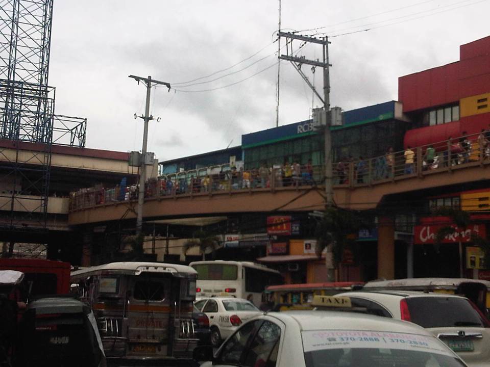
 Pedestrians can no longer cross at-grade at the intersection of Quezon Avenue and Araneta Avenue. Note the vendor in the photo (with umbrella) crossing counter-flow with his pedicab full of plastic merchandise. The cyclists in the photo are risking their lives and limbs in crossing the intersection. Fortunately for them, there seems to be no traffic enforcers around to apprehend them. The “yellow box” has been replaced by a “red box” in many intersections including this one.
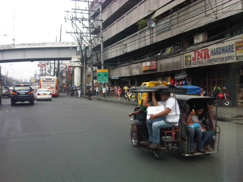
 The pedestrian overpass at Quezon Ave.-Araneta Ave. as seen from the sidewalk along the Q.C.-bound side of Quezon Ave. The sidewalks are often obstructed by vendors but fortunately the overpass itself is not clogged by vendors unlike other overpasses.
 This overpass along EDSA is the outcome of pedestrian crossings being only an afterthought (some would say aftermath) of the EDSA MRT design. It is an example of the “pwede na yan” (this will do) attitude of many engineers and architects when it comes to transport systems.
All of the above examples are found in Quezon City. That city is among the most wealthy cities in the country and there have been a lot of transport-related developments in the past few years that are more people oriented. These include the construction of sidewalks, overpasses and underpasses outside those typically under the MMDA. However, there are still a lot to build and may I say correct in order to promote walking and other non-motorized transport in the city. Quezon City and other cities can be walkable cities and walkability should not be limited to CBDs that are often (and again) passed on to the private sector for development. LGUs should not be too dependent on what the private sector can offer in terms of infrastructure for walking and cycling. There are not many responsible private companies out there who would commit resources towards walkable and cycling-friendly developments. Often they are tempted to maximize space for buildings, even sacrificing space for parking and motor vehicles, and ultimately at the expense of the general public. This is where LGUs, and not even national government, comes in to put things into order. However, the caveat here is that LGUs should have a plan to guide them in development and again, there are few LGUs that have this capability and capacity to plan and implement such plans. And here is where national agencies like the DOTC and the DPWH can provide help to LGUs given their resources and expertise.
–
