
Home » Railways (Page 15)
Category Archives: Railways
Commuting on the LRT Line 2
Metro Manila’s LRT Line 2 stretches from Santolan in Pasig City to Recto in the City of Manila. It is the only suburban railway line serving Metro Manila outside the PNR, and uses trains that have the highest passenger capacities compared to the LRT Line 1 and EDSA MRT (Line 3), which uses cars that can be categorized as light rail vehicles. Line 2 employs vehicles that would elsewhere be used for metros or surface heavy rail transit. I occasionally use Line 2 for commuting between Katipunan and Cubao but I must admit I haven’t used it to commute all the way to Manila. Following are photos I took on one commute between Katipunan and Cubao.
 Going underground – descending to the station at Katipunan, there are no escalators so most people have to use the stairs.
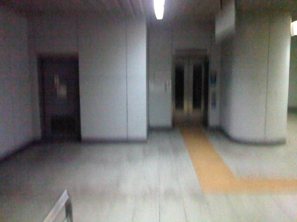 Accessibility – there are elevators for the physically-challenged including persons with disabilities (PWDs), senior citizens and pregnant women.
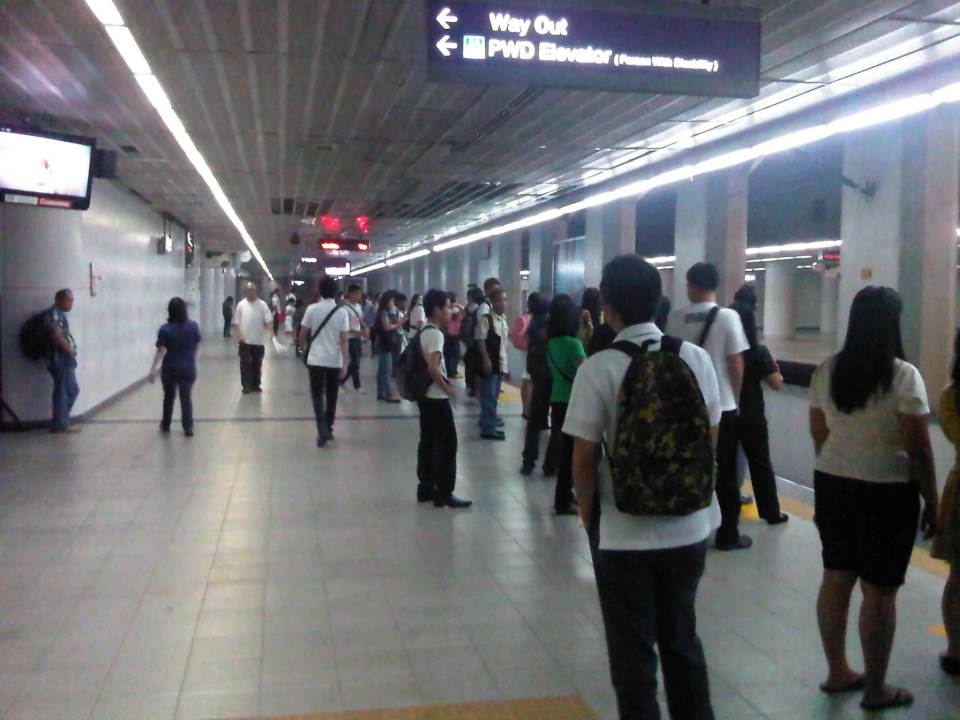 Katipunan Station platform – is underground and gives the feeling of being in a subway. There are directional signs to guide passengers but I think there should be more signs informing people about train arrivals and schedules. Note that most passengers do not form lines and are standing along and near the entire platform edge. This seems to indicate people are either undisciplined or there is little effort to establish order in boarding and alighting procedures.
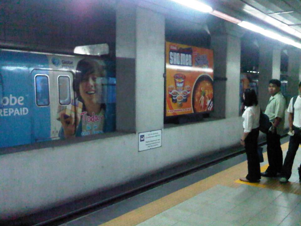 Passengers waiting along the platform form lines where the trains’ doors are supposed to be positioned once the vehicle is stopped. In other countries there are also signs along the median to guide passengers where to line up along the platform and to give way to people alighting from the trains before boarding the train. Such procedures are important for orderly operations. A train bound for Santolan Sta. is on the other side of the platform.
 Passengers boarding the train
 Stragglers hurrying to enter the train before the doors closed for departure. Like in other cities, some passengers attempt to board the train at the last second. Such situations can cause injury as people can get caught by the closing doors.
 Train leaving the Katipunan Station and bound for Recto in Manila
 Warning sign – signs inform passengers of the dangers along the tracks. In this case, the danger is in the form of high voltage wires as the trains are powered by electricity. There is a fine of PhP 50,000 (~USD 1,200) for anyone illegally going down to the tracks.
 The yellow line defines the area where passengers should be safely behind and clear of the trains. There are dimples on the line, which are generally for the benefit of blind people using their canes to “feel” such lines for guidance.
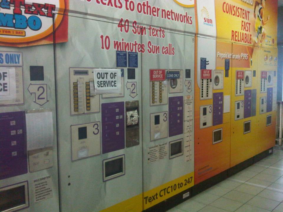 Defective – Most ticket machines were out of service. Those that weren’t marked as defective (just a few) had problems accepting coins. This issue regarding ticketing makes it inconvenient for most passengers to use the trains as they end of queuing along one or a few manned booths selling tickets at the stations. One would think that with so many options now available for fare collection (tickets, passes, cards, etc.) and the LRT’s already in operation for so many years that authorities would have already had a more efficient system in place for fare collection.
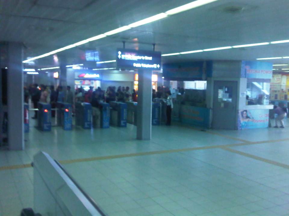 Turnstiles – there are enough turnstiles at the stations (in this case Cubao) but the queuing problem is not here but at the ticketing stage of the journey. Of course, there are also queues due to the security checks at the station but these are usually quicker compared to the time it takes for people to purchase tickets.
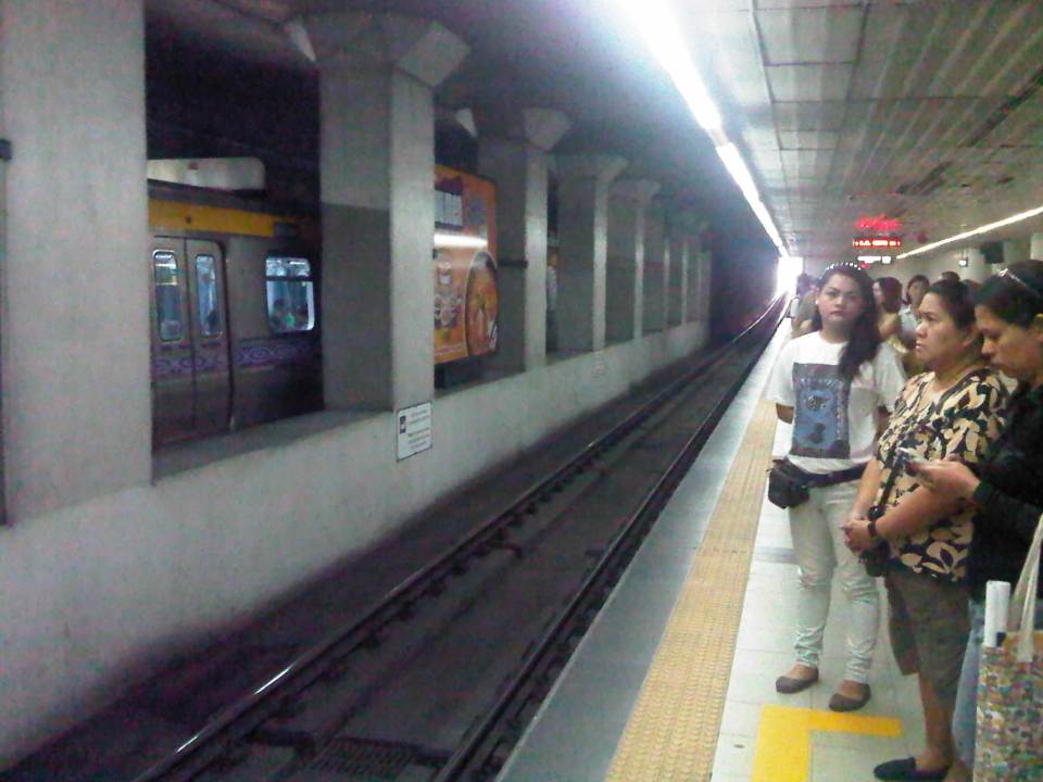
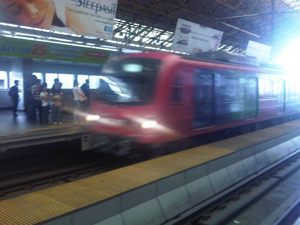 Westbound arrival – a train bound for Recto arrives at the opposite platform at Cubao Station.
 Departures – a train bound for Manila leaves Cubao Station while passengers form queues along the platform for trains bound for Pasig.
I tried to get photos of the connection between the Cubao Station and Gateway Mall but the pictures didn’t come out right (Note: I usually only use my cell phone to take quick photos.). The same was the fate of photos I tried to take between Katipunan Station (Exit at St. Bridget’s) and the UP-Katipunan jeepney terminal. In the latter case, the rains and the crown prevented me from taking photos. I will try to get better ones to post next time and perhaps that post will focus on the conditions around stations including their connectivity to other modes of transport (e.g., convenience of transfers) and other aspects such as walkability.
–
Rationalizing public transport in the Philippines
I got a copy of the recent study “Development of a Mega Manila Public Transportation Planning Support System” conducted by UP Diliman’s National Center for Transportation Studies (NCTS) for the Department of Transportation and Communications (DOTC). The main outcome of the study was a planning support system that includes an updated database of bus, jeepney and UV Express routes for Metro Manila and its surrounding areas (collectively called Mega Manila), and a calibrated travel demand model for the region that is supposed to be used by the DOTC and the LTFRB in transport planning including the rationalization of public transport in the region. Among the notable recommendations for addressing public transport issues is the following on the classification of routes according to passenger demand, which I quote from the study:
“…routes and modes may be classified and prioritized as follows:
- Routes with Very High Passenger Demand [>160,000 passengers per day] – shall be served by high capacity modes such as rail-based transit or Bus Rapid Transit(BRT) with passing lanes.
- Routes with High Passenger Demand [100,000 to 160,000 passengers per day] – shall be served by high capacity vehicles such as Bus Rapid Transit System (BRT) without passing lanes;
- Routes with Medium Passenger Demand [10,000 to 100,000 passengers per day] – shall be served by PUVs with 60 or less passengers/seats but not less than 22 passengers (excluding driver) such as buses, CLRVs with more than 22 passengers/seats (including driver), or with 90 passengers/seats in the case of double decker or articulated buses;
- Routes with Low Passenger Demand [not exceeding 10,000 passengers per day] – shall be served by PUVs with less than 22 passengers/seats (including driver) such as jeepneys and other paratransit modes.
Under this principle, high capacity modes would have priority in terms of CPC allocation and transit right of way in a particular route over lower capacity modes with the exception of taxis. The latter, after all, operate as private cars rather than PUVs with fixed routes.
Applications to operate bus and/or minibus service in jeepney routes can be considered, but not the other way around. Similarly, bus service applications can be considered in minibus routes but not otherwise.
Based on the analysis of routes, the establishment of public transportation routes and the corresponding modes of services may be based on the following criteria:
• Passenger demand patterns and characteristics
• Road network configuration
• Corresponding road functions (road hierarchy)
• Traffic capacities and
• Reasonable profits for operation of at most 13% ROI.”
[Source: DOTC (2012) Development of a Mega Manila Public Transportation Planning Support System, Final Report.]
An interesting figure in the report is an illustration of how services can be simplified using buses and rail transport as an example. The following figure shows two maps: one showing the plotted EDSA bus routes (left) and another showing a more consolidated (and rational) route network for buses complementing existing and proposed rail mass transit systems.
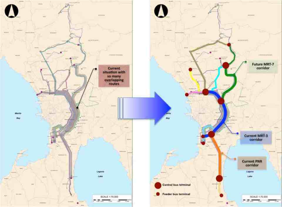 Simplifying bus transport services (source: DOTC, 2012)
What are not included in the figure above are the prospects for Bus Rapid Transit (BRT) systems for Metro Manila. Since the Final Report was submitted in mid 2012, there have been many discussions for BRT in the metropolis and current efforts are now focused on the assessment of a BRT line along Ortigas Avenue. The World Bank is supporting the evaluation of a route between Tikling Junction near the boundary of Antipolo and Taytay (Rizal Province) and Aurora Boulevard. There are also informal talks of a BRT line along Commonwealth Avenue but that would have implications on the proposed MRT-7 along the same corridor. Nevertheless, such mass transit systems have long been required for Metro Manila and their construction have been overdue. A more efficient public transport system will definitely have tremendous impacts on how we commute between our homes, workplaces, schools and other destinations. Long distances can easily be addressed by better transport options and could actually help solve issues pertaining to informal settlements, relocations and housing. That topic, of course, deserves an article devoted to this relationship between transport and housing. Abangan!
–
Transport gaps
I first learned about the concept back in the 1990’s when I was a graduate student at UP majoring in transportation engineering. The concept on transport gaps was first mentioned in a lecture by a visiting Japanese professor as he was discussing about transport modes, particularly on which was suitable or preferable over certain travel distances and which could carry more passengers. Another time later and while in Japan, I heard about the concept during a presentation of a friend of his technical paper on public transport.
The figure below is one of many possible illustrations of the concept of transport gaps. In the figure, a distinction is made for mass transport and individual transport. As the original figure is likely taken from a textbook or a paper (probably from Japan), shown with a white background are the more conventional modes of transport including subways, urban and suburban railways, walking and a mention of the shinkansen (more popularly known as the bullet train). With a gray background in the original figure is a category on new urban transit systems that include monorails, AGTs and LRTs. If we attempt to qualify local transport modes such as jeepneys, UV Express, tricycles and pedicabs into the graph, the outcome can be like what is illustrated with different color backgrounds in the figure below.

The concept of transport gaps allow us to visualize which modes are suitable for certain conditions where other established modes of transport may not be available or viable. In the original figure, the gap in Japan is filled by new urban transit systems. In our case, gaps are filled by so-called indigenous transport modes such as jeepneys, multicabs, tricycles, pedicabs and even habal-habal (motorcycle taxis).
There are gaps in the Philippine case probably and partly because of the slow development of public transport systems such as the mass transport modes shown in the preceding figure. There was a significant gap right after World War 2 when the tranvia and other railways were destroyed during the war. That gap was filled by the jeepney. There was also a gap in the early 1990’s that was eventually filled by FX taxis. Such gaps can obviously be filled by more efficient modes of transport but intervention by regulating agencies would be required and rationalizing transport services can only be addressed with the provision of mass transport options complemented by facilities for walking and cycling that will complement these modes.
–
What if Manila retained its railway lines of old?
It is possible to trace the old railway lines of Manila to the towns to its east in what is now Rizal Province. I had seen it in one railway blog that one of my students showed me after we took up the history of railways in the Philippines where I showed them old maps of the railways in the Philippines. And so based on the descriptions found in those maps and texts combined with familiarity with the places mentioned there and the availability of a tool like Google Earth, it is possible to produce the following images showing two particular lines that could have been “game-changers” for a lot of people taking public transportation between Metro Manila and the areas to its east (i.e., towns in Rizal Province).
 Traces of railway lines of old from Tutuban in Manila to Antipolo (blue) and San Mateo (green)
 The blue line extending to Antipolo City passes through an area that is part of Valley Golf and ends up near the Antipolo Church (Shrine of Our Lady of Peace and Good Voyage). This line could have been a major mode for commuters residing in Antipolo, Taytay, Cainta and Pasig City.
 The line extending to San Mateo, Rizal passes through densely populated parts of Pasig and Marikina Cities. The line could have served people residing in these towns all the way to Rodriguez (Montalban).
The outcomes of the exercise of tracing old railway lines as shown in the previous photos allow us to appreciate and maybe contemplate on the “what ifs” and “what could have beens” if the Philippines did more efforts in retaining its railway system after the Second World War. I do not think planners at the time were able to anticipate the rapid development of the area that was to formally become Metro Manila in the 1970’s. While the road network plans were in place, thanks to the design by Daniel Burnham, what Manila and its environs needed was a transit network that did not depend on roads and something that would have been able to carry much more people (and maybe even freight) than the jeepneys and buses that emerged postwar. Perhaps we were not doomed to the current choices that we have and commuting would have been much simpler than the terrible experience many people from these eastern towns have every weekday. I leave it up to the reader to imagine how comfortable and convenient travel would have been along these lines.
–
Railway safety in the Philippines
As the Philippine National Railways (PNR) attracts more passengers and (currently) more support translating to more resources, it is hoped that the company will finally take off and perhaps help improve public transportation and commuting in general. The PNR has been experiencing a renaissance of sorts with the increased frequency and capacity for its commuter line. This, despite still many limitations pertaining to hardware such as its rolling stock and railway tracks (i.e., the PNR has double tracks only along its line Caloocan to Alabang, the rest is single track). The acquisition of newer trains for the commuter line and the upgrading of railway tracks helped revive flagging ridership though service frequencies are still quite limited due to the limitations mentioned. Among the major issues the PNR is still facing at present are encroachments to its right-of-way and safety concerns at the many level crossings along the tracks. While there have been efforts to improve safety by adding devices such as barriers and posting personnel to manage road traffic when trains are passing through, the system is still wanting in terms of safety and there has been a rash of incidents along its commuter and Bicol lines involving road vehicles and pedestrians. Of course, these are not all the PNR’s fault considering there are many “pasaway” people who still insist on crossing the tracks despite warnings of an arriving train. I am featuring below some aspects of rail and road safety that my students have collected during their research on the state of the PNR commuter line.
 PNR Commuter Line train
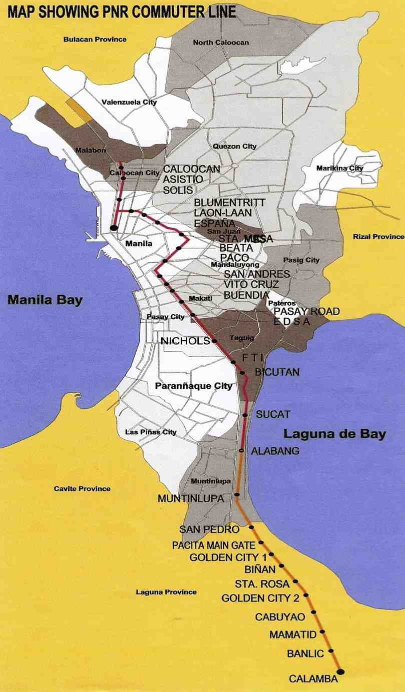 The PNR Commuter Line – indicated in red is the double track (two-way) stretch and in orange is the single track (one-way) part of the line that ends in Calamba. The line to Bicol is also single track.
 Map showing the list of level crossings along its Commuter Line between Caloocan, Manila and Calamba
 The PNR defines a diamond-shaped clearance at all level crossings. The diagram above was secured by my students from the PNR, clearly illustrating the area within which there should be (ideally) no obstructions.
 The concept of diamond clearance as applied to level crossings at Malugay, Buendia (Gil Puyat) and Dela Rosa in Makati City.
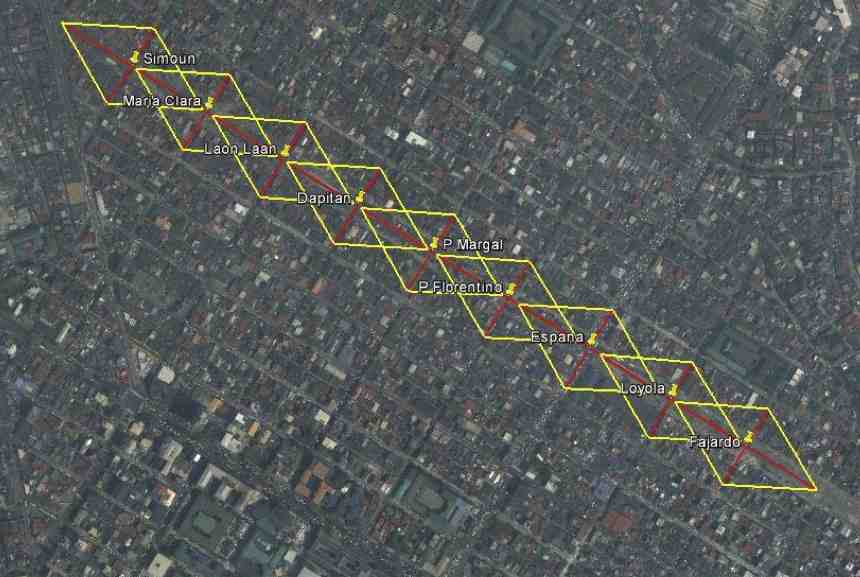 The diamond clearance concept as applied along level crossings in Manila.
It is unfortunate that there was a recent derailment of a train in Bicol due to the failure of the railway tracks’ (soil saturation due to heavy rains). This incident will surely set back services until the section has been repaired and perhaps reinforced to prevent such happening again in the future. I always imagine the PNR’s Bicol Express during its glory days as my father has related stories of how good its service was then. This romanticized idea of rail is still alive today and the addition of sleeper and air-conditioned cars have attracted tourists visiting the Bicol Region to use the PNR. It is hoped that this could be sustained and services expanded in the near future. Of course, investments should go into make the Bicol Express line double track in addition to more trains to accommodate two-way traffic. I wouldn’t dream yet of high speed rail for this corridor but decent train services should be able to compete with buses and give travelers a safe and efficient option for travel over land.
–
Using the Bangkok subway
I have gone around Bangkok in the past using the BTS Skytrain, buses, taxis and once using the tuktuk. I have only used the subway once as it has only one line and in the past trips to Bangkok I really didn’t need to use it considering most of my destinations were within walking distance of a Skytrain station or required the services of a taxi. And so I took the opportunity to take some photos at the Bangkok Metro during one commute to meet up with a friend.
 Directional sign guides people coming from the Skytrain platform to the MRT, Bangkok’s lone subway line
 Descending from the Skytrain station to the entrance to the subway station
 Directional signs guide commuters to the subway station
 Another descent, this time to the subway station plaza to purchase a token (instead of a ticket) to ride the train
 User interface for the Bangkok subway – commuters who can’t read Thai may opt to go for the English option. Unfortunately, the MRT’s system is not integrated or compatible with the Skytrain’s and so I could not use my Rabbit card for my fares. I think the MRT should work on this as it would be to their advantage.
 The station is spacious and there seems to be still few passengers using the subway – Fares have been criticized before for being expensive compared to bus and Skytrain. As such, the system is not as crowded as Singapore’s MRT or the Philippines’ elevated rail systems.
 Platform doors are synchronized with the train doors, ensuring safety for commuters.
 Turnstiles are similar to those in Singapore and Japan
I think the Bangkok subway is still a good option along the corridor it serves though it would be better if it is extended to increase its reach and consequently its ridership. Issues on inter-connectivity with other modes especially the Skytrain have been addressed to some extent but remain. Its most difficult challenge pertains to fares and is something that would probably be difficult to tackle given the financial implications but is necessary to encourage more people to use it regularly.
–
Airport Rail Link in Bangkok
The last time I was in Bangkok was in 2005 or 2006 and so it has been a while since that last trip that I was curious about how the city would look like after 6 years. Was there anything new? Did it change much since the last time? At the very least, I was expecting to have new experiences and it didn’t take long before I had one, trying out the express rail link between Suvarnabhumi Airport and the city. The rail link was still under construction the last time I was in Bangkok and one had no choice at the time but to take a taxi or a shuttle between the airport and the hotel.
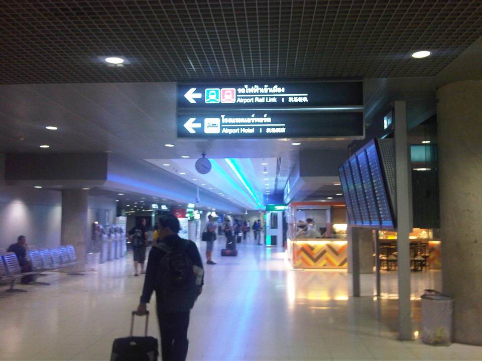 The walk from the arrival area to the Airport Link
 Ticket vending machine with English instructions upon the press of a button. We purchased tickets for the Phaya Thai Express to transfer to the BTS Skytrain
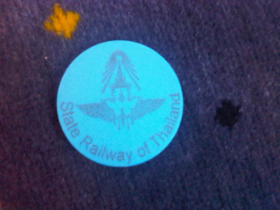 Token for the Express Rail Link trip from the airport to Phaya Thai Station – the link is operated by the State Railway of Thailand, their counterpart of our Philippine National Railways. The trip cost 90 Baht (~ 130 PhP), very cheap compared to taking a taxi.
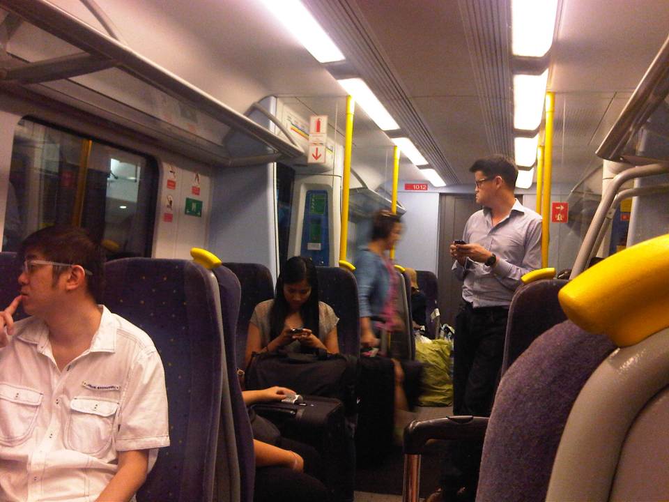 Passengers inside the Airport Link Train
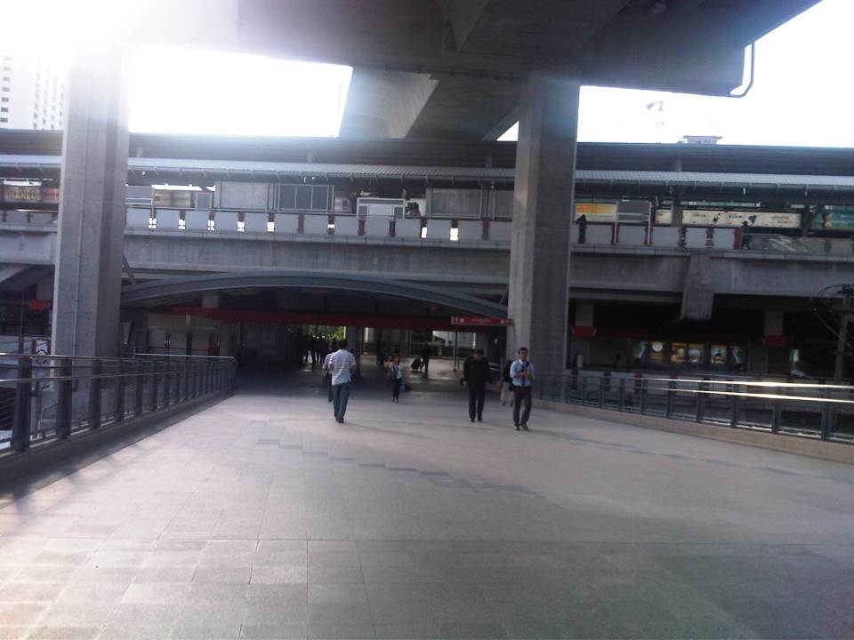 Walk from the Airport Rail Link’s Phaya Thai Station to the BTS Skytrain Station
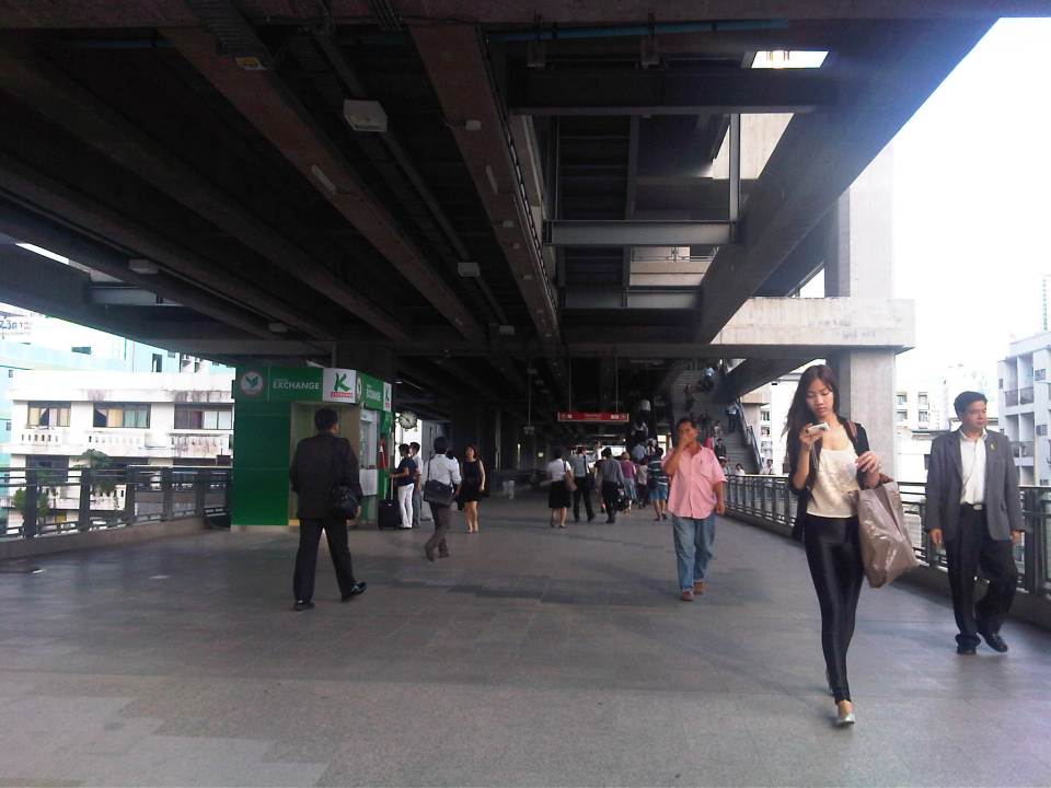 Looking back at the Phaya Thai Station
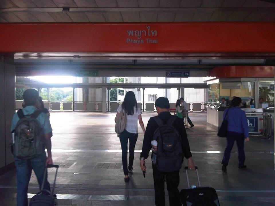 Phaya Thai Station of the BTS Skytrain
It would be very nice to have a similar rail link between the MRT 3 or LRT 1 Lines and NAIA in Manila. In fact, how difficult would it be for the LRT1 Line to have an extension to the airport terminals of NAIA when it’s depot is just across the road from the old domestic terminal? This would probably be easier than constructing a new monorail or whatever system it is that is being planned between Bonifacio Global City and NAIA. It is definitely much easier and perhaps cheaper compared to the still-born Northrail between Caloocan and Clark. One thing for sure is that we are really behind our ASEAN neighbors when it comes to providing the infrastructure for public transport, in this case airport access.
Philippine railway plans in 1903
I was browsing the book by Arturo Corpuz (The Colonial Iron Horse: Railroads and Regional Development in the Philippines 1875-1935, U.P. Press, 1999) and remembered there was a figure there that illustrated what looked like an ultimate plan for railways north of Manila. The map, shown below, indicated that what was the Main Line North (MLN) was already planned to be extended all the way to Laoag in Ilocos Norte from the existing station in Dagupan, Pangasinan.
 PNR expansion plans in 1903
The map also shows proposed and alternate plans for a branch of the railways run along the Cagayan Valley and all the way to Aparri, Cagayan. The map along with others from that period reinforce what I have termed as probably one of the biggest “what ifs?” in Philippine transport. If such plans were implemented and we had retained and even upgraded these lines, perhaps inter-provincial or inter-regional passenger and freight flow in Luzon could have been significantly different from what we currently have that is dominated by road transport. A fully developed MLN and MLS could have been game changers in the development of Luzon and the country in general. Long distance travel for both people and goods may not have been dependent on road-based vehicles, and perhaps could have been more affordable for many people before the emergence of air transport and the present’s budget airlines. In fact, a fully developed railway system could give budget airlines and bus companies a run for their money today and perhaps influence tourist transport as well.
–
PNR Naga City Station
The wife recently went on a trip with her father to attend a family affair in Naga City in Camarines Sur. Arriving by plane in the morning, they went to the PNR station in the afternoon to purchase a ticket for my father-in-law who wanted to try the train for the trip back to Manila. He got word of the resumption of Bicol Express services from me as well as from the news. The PNR had been featured on TV and he had been curious about taking the train. He used to take the train for trips between Naga and Manila before and told us stories of how nice traveling by train was back in the day. Following are a few photos around the Naga Station of the PNR.
 Aren’t we glad? – The PNR Naga Station has been renovated and now features updated office buildings and ticket counters
 Contrast the new and the old – PNR’s old coaches at the newly renovated platform
 Room for improvement – passengers waiting along the platform with some seated on the few benches available
 Simplicity – don’t expect turnstiles yet and it’s still somewhat a crude entrance to the platform but these should improve soon as passenger demand steadily increases.
 5
5
 Looking forward – the train at the platform was bound for Legazpi City, Albay and I like to think the photo The photo actually shows the back end of the train as the front end is pulled by the locomotive shown in a previous photo.
 Old workhorse – this diesel electric locomotive pulling the passenger coaches and a few others like it have been
 View from the top – there are pedestrian overpasses crossing the tracks for access to platforms and other parts of the station. Visible in the photo are discarded bogeys and the blue car that is an executive class coach with reclining seats.
 Regular and Special – the train on the left and parked alongside the platform has regular coaches with fixed seats much like the Tokaido Line long distance commuter trains. The train on the right has executive class coaches with reclining seats and more space for passengers that translate to a more comfortable ride. Unfortunately, there were no sleeper cars with either trains at the time.
–
North EDSA
Heading to Tutuban for our technical visit of the Philippine National Railways, we passed along the north segment of EDSA from its junction with North Avenue in Quezon City to 8th Street in Caloocan City. Following are photos showing the overhead LRT 1, the motorcycle lane, U-turn slots and various buildings adjacent to EDSA.
 EDSA – North Avenue junction – the blue lane markings designate the motorcycle lane along EDSA. SMDI’s Grass Residences can be seen behind the mall.
 Section in front of SM North EDSA – the bus stop beneath the SM Sky Garden is on the right of the photo
 Section after SM North – the green building is Quezon City Academy
 Section in the vicinity of Roosevelt Ave./Congressional Ave.
 Section between Corregidor St. and Roosevelt Ave./Congressional Ave.
 LRT 1 Extension Roosevelt Station
 Section after Roosevelt Ave./Congressional Ave. before Fema Road
 Section approaching Home Depot and Kaingin Road junction
 Section across from Shell Station right after Wilcon Builders Depot
 Section across from Hyundai dealer right after Shell station
 Section approaching Balintawak LRT Station
 Section along Munoz Market (note the cart full of vegetables on the right in the photo)
 Exit ramp to NLEX at the Balintawak interchange (cloverleaf)
 Section of EDSA on top of NLEX (Balintawak interchange)
 Section right right after the interchange – vehicles on the rightmost lane are those coming from NLEX southbound and coming on to EDSA northbound
 Section after Toyota Balintawak and Gen. Evangelista, and approaching Gen. Mascardo
 Section approaching 8th Street U-turn slot after Mariano Ponce
 Vehicles stopped at intersection/U-turn slot to allow vehicles turning left from EDSA northbound to 8th Street
–
