
Home » Transport Planning (Page 33)
Category Archives: Transport Planning
UP-AGT test runs
Happy New Year!
I start the year with a short feature on the Automated Guideway Transit (AGT) prototype at the University of the Philippines Diliman (UPD) campus. The prototype has been featured in a number of articles in quad media in the recent weeks of November and December after its delivery and a few runs along the elevated test track at the campus. A project of the Department of Science and Technology (DOST) through its PCIEERD and MIRDC, and in cooperation with UPD, the vehicle has caught the attention of the general public and particularly those who have advocated for better public transport services in Metro Manila and other Philippine cities. Many are excited about the prospects of a “home-grown” system being constructed and operated in Metro Manila, and the buzz about the AGT replacing the IKOT jeepneys of UP Diliman is still very much alive despite clarifications by both the DOST and UP about this being a R&D project as well as questions regarding sustainability and practicality. Following are a few photos of the AGT prototype during one of its demonstration runs last December.
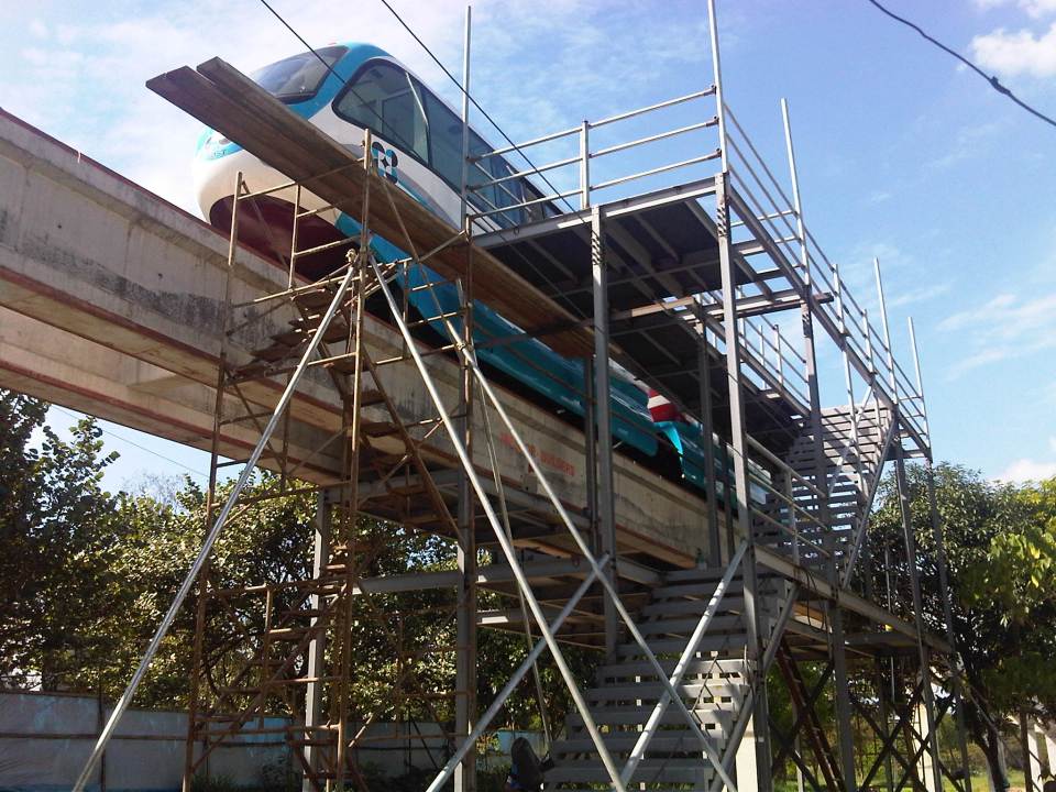 Unfinished platform at the Jacinto Street end of the test track allowing access to the vehicle’s underside and bogey and the loading platform
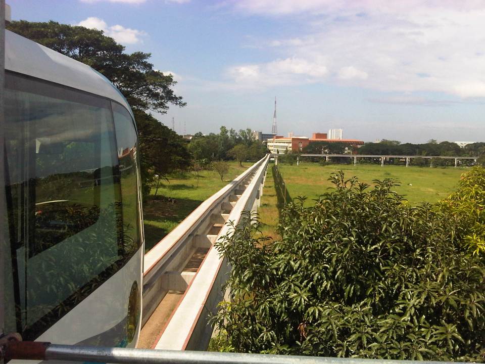 View of the test track from the platform – note again the absence of rail tracks as the AGT employs rubber tires. Wheels travel along the two concrete guideways shown in the photo. That’s the CHED building along C.P. Garcia Ave. downstream from the position of the AGT
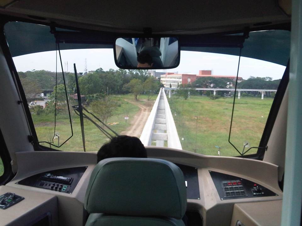 Driver’s perspective of the test track – the vehicle will eventually be driver-less (hence, automated) but for the test runs, there will initially be a driver to make sure the train operates correctly
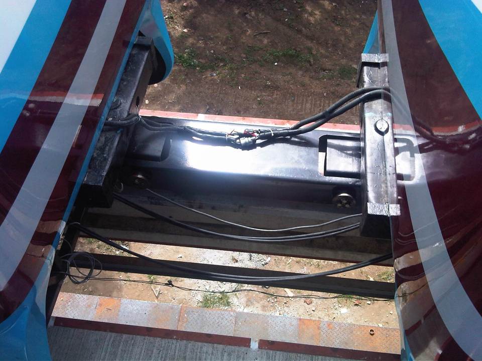 Connection – the two prototype vehicles are connected by this crude assembly that is definitely one of the things that would need to be reconsidered in subsequent vehicles. Perhaps an automatic coupler should be installed in the future?
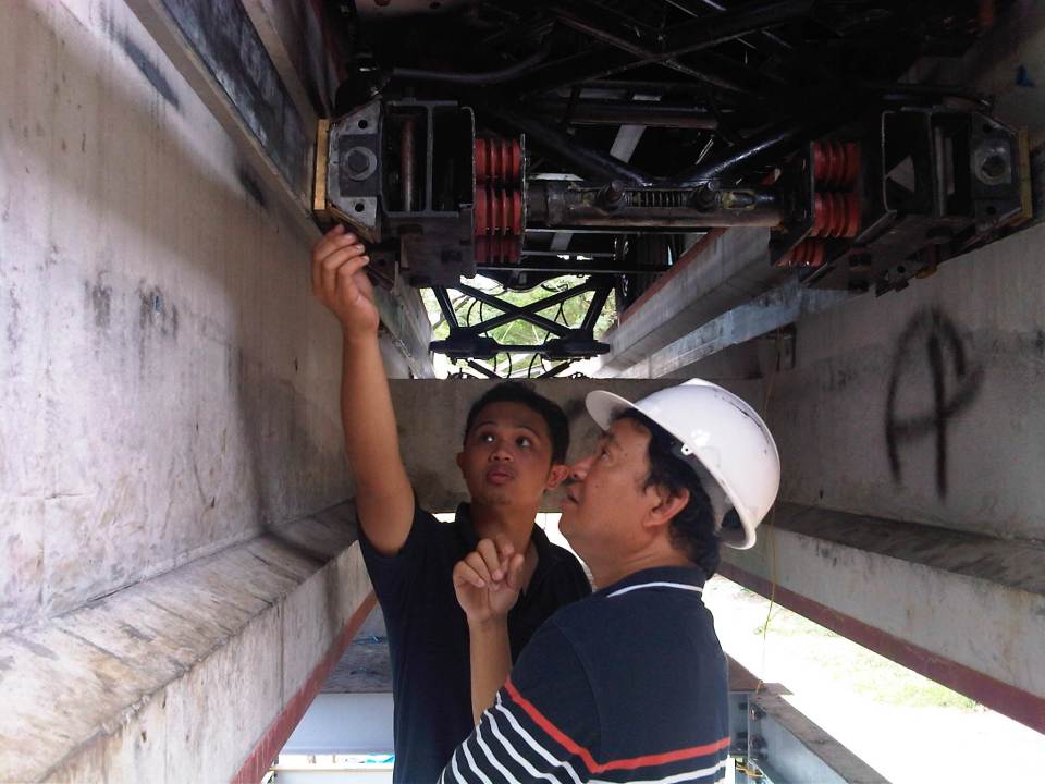 Dr. Ric Sigua of the Institute of Civil Engineering inspecting the pick-up system for the AGT prototype with DOST project staff.
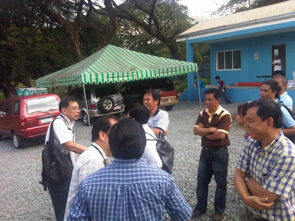 DOST-PCIEERD and UP Diliman faculty (from the Institute of Civil Engineering, Department of Mechanical Engineering, Electrical and Electronics Engineering Institute and School of Urban and Regional Planning) exchange ideas on the prototype.
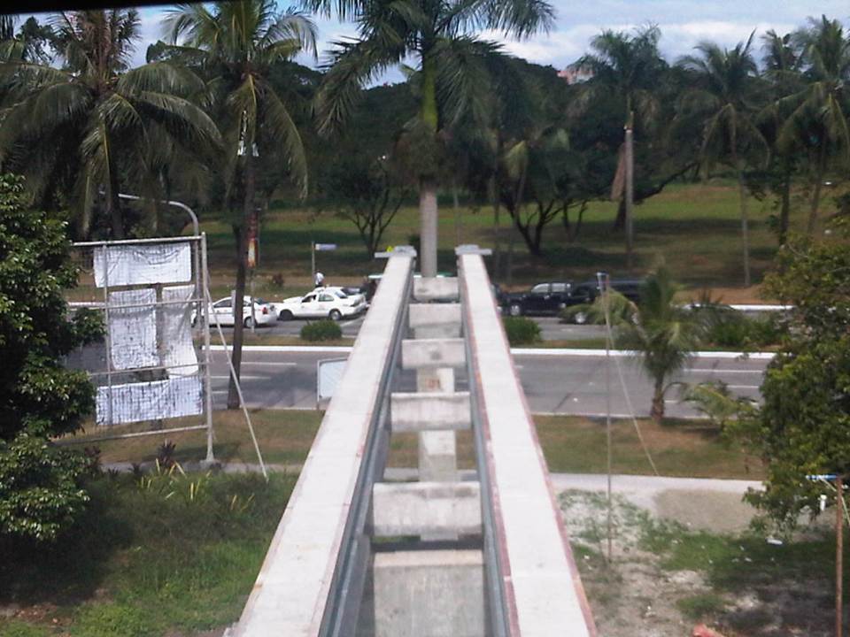 View of the end of the test track showing the two guideways employed by the vehicle and traffic along the University Avenue
The initial runs of the AGT have been exclusive demonstrations to government officials including those in national agencies, guests from the private sector, and partners with UP Diliman. The formal test runs will start in January 2013 but there are still no details on how these will be carried out in order to determine the functionality and safety of the prototype. Already, there are informal discussions on what needs to be improved in the prototype based on the initial observations and inspections conducted by faculty members from UP Diliman’s College of Engineering who will be involved in the technical evaluation of the prototype. Hopefully, such evaluations can be completed at the soonest and improvements are considered prior to a full system eventually being constructed and made available for public use. Where that system can be constructed and operated is still up in the air but should definitely be somewhere where the system is needed and where it can be a showcase for localized technology.
–
Hierarchy of transport modes
To better understand issues regarding our transportation system in the Philippines and elsewhere, I am showing two diagrams that both describe hierarchies of transport modes. The figures illustrate a concept much like our concept of the food pyramid where many if not most could easily understand in terms of what we need more of and less of in terms of proper nutrition. Transpose this concept to transport and we can understand that the most basic mode of transport is and should be on top of an inverted triangle, which represents which modes re to be prioritized over the others. The figure can also be used to symbolize mode shares. In terms of both priority and mode share, walking is the most dominant as we all walk. As such, it is only logical that facilities be provided for everyone to be able to walk safely and efficiently. These facilities include sidewalks, overpasses and underpasses that would encourage walking over other modes (especially the motorized ones). Walking is the most equitable and sustainable among transport modes and is definitely the healthiest.

For public transportation, another diagram may be constructed to show which modes can carry more people. Though the following figure is somewhat customized for Philippine public transport, it does not include multicabs, FX/AUVs, van-type services, and other paratransit modes (e.g., habal-habal, kuliglig, etc.) that are found throughout the country. There should be similar hierarchies in our ASEAN neighbor countries as they also have their indigenous modes like the tuktuks and samlors of Thailand.

Of course, each mode of transport is suitable for different trips with non-motorized public transport (particularly the 3-wheeler pedicabs, trisikad or padyak) being most appropriate for short distance trips though such trips can also be covered by walking. Jeepneys and multicabs are suitable for medium distance travel (~4 to 10 kilomemeters) where ridership is not yet viable for buses but which would have been serviced by too many tricycles. There is a reason from the perspectives of safety and efficiency why pedicabs and tricycles are not encouraged along national roads and jeepneys are not supposed to be plying routes along EDSA and C5.
Going up the hierarchy would have cost implications and rail transit is the most expensive mode in terms of capitalization, operations and maintenance. Of course, there are different type of rail transport services that include light rail to the long distance heavy rail commuter and regional services. As such, these systems require investment as well as foresight for the eventuality of a large, populous urban area ultimately requiring rail transport to carry so many passengers over longer distances. Rail alone would probably be insufficient so it needs to be complemented by bus and perhaps jeepneys as well. The emergence of Bus Rapid Transit (BRT) has provided city and transport planners with a flexible option bridging rail and bus transport in terms of cost and passenger capacities and are now being considered as immediate solutions for travel demand and public transport needs in major cities.
–
Sound bites on transport and traffic
If there was one thing I both dreaded and enjoyed during my 6-year stint as head of UP’s National Center for Transportation Studies, it is granting interviews to the media. My predecessors warned me about how some media outfits have been notorious for editing interviews to suit their needs. In certain cases, they are alleged to have spliced recordings that if taken as is would have been boring or not quite informative in order to have material that were more sensational. There are features, for example, where it seems interviewees were responding to the each other’s opinions making it look like they were arguing. And then there are those where certain statements are taken out of context when cut from a long explanation in the actual interview that took place.
I think I tried my best to be careful about what I said and how I explained or related things in my interviews. I looked at interviews as a way the Center could reach out and advance its advocacies. These were opportunities to spread the message of sustainable transport, to educate and inform officials and the public about what we should aspire and work hard towards achieving in transport and traffic. I think we had to be both progressive and aggressive with our messages because it was our duty, our responsibility not just to do research and train people but also to inform and educate people about sustainable transport. Popular mass media is an effective way to do this and we should be engaging but careful about our messages in order to be constructive and fair.
The last news interview I had before finally being relieved of being holdover Director for a month after my term ended was with GMA News. I like this interview about traffic congestion because I was able to put in some of the ideas that people in the forefront of sustainable transport have been preaching and practicing. These include the truth that in developed countries and cities, the wealthy take public transportation and that in order to improve public transportation, decision makers should themselves experience commuting.
These are not new ideas and I have to be clear that these were not my original ideas but those that I have come to embrace and advocate. I truly believe that if we don’t take public transportation, walk or cycle, we can’t really have a clear picture of what our cities need in order to solve the traffic mess and come up with services that are safe, efficient, inclusive and equitable.
The feature appearing on Jessica Soho’s State of the Nation on Channel 11 from the GMA News website.
The same report that appeared in the primetime 24 Oras:
–
Updates on the UP AGT
The prototype vehicles for the Automated Guideway Transit (AGT) project of the DOST through its PCIEERD and MIRDC were delivered last Sunday, November 25, at the test track site in UP Diliman. The two vehicles will form the train that will be mounted on the test tracks and subject to experiments to test the performance and functionality. Researchers from UP Diliman, including faculty members from its College of Engineering and College of Science, will be cooperating with the DOST to provide advise on issues that are certain to crop up once the tests are underway.
Contrary to many reports coming out that it will be an “upgrade” or “replacement” for the Ikot and Toki jeepneys currently operating inside the campus, the truth is that a Phase 2 creating a loop around the campus is not viable for the foreseeable future. For one, the system will be too expensive to build, operate and maintain for a very limited ridership that is attributed to UP Diliman, even with the increasing numbers of through trips using UP public transportation. Of course, it would be nice to have a system like this in campus but the costs cannot be covered by revenues from fares. Funds for construction (investment costs), seen from one perspective, may be of better use elsewhere where resources are in dire need to support other very important endeavors. A full system would be appropriate elsewhere and with funding coming not from the DOST or UP budgets but from airports, developers, local governments and others who can be the proponents for such systems.
 AGT vehicle delivered at the test site in UP Diliman – the streamlined body was designed by DOST project staff. The skirt helps to hide the bogey, which includes the mechanism for the vehicle to pick up power from rails embedded along the guideway.
 Inside the vehicle – there are few seats behind the driver’s cab to maximize space for (standing) passengers. This layout is very much similar to other AGTs and monorails including those serving airports where users would also have luggage with them.
 Driver’s cab – although the intention is for the vehicle to be ultimately driverless, tests will initially be conducted with a driver.
 Back seats – there are a few more seats at the back but the layout maximizes the number of standing passengers.
 Another look at the AGT vehicle – the DOST logo is prominent in the front and one side of the vehicle. The UP logo is on the other side of the vehicle.
 Test tracks – the AGT guideway is elevated and stretches to almost 500 meters. For reference, the photo was taken from near the project office/power house with the CHED building along C.P. Garcia Ave visible downstream of the elevated guideway. The line of trees on the right is along the University Avenue.
While it is understandable that certain rail aficionados have become excited about the prospects of having an operational, functional AGT or monorail, the UP-AGT is really an experimental system. It is best considered as a “proof of concept” project that will hopefully encourage the development and promotion of public transport in many of our cities that seem to be mired in having unsustainable transport modes. But of course, any transit system such as this will not survive if no rationalization in transport services are implemented and this is particularly true if an AGT or monorail would have to compete directly with buses, jeepneys or tricycles.
–
On runway configuration and orientation
We teach our students the basics of Airport Engineering including design principles for airside and landside facilities. The most important airside facility is the runway and there are several factors affecting the determination of runway configuration and orientation. Even for single runways, these factors are critical in order to ensure safe and efficient operations. Factors affecting runway configuration and orientation include:
1) Wind – the direction and magnitude of the wind is critical for aircraft as headwinds help generate the lift required for taking-off and cushioning landings. Headwinds will tend to shorten runway length requirements due to this assistance with lift while tailwinds will tend to increase runway length requirements. Cross winds are undesirable as they may cause aircraft to roll or stall. A useful tool for establishing wind behavior (e.g., directions and speeds) is a wind rose, which requires many years of data on wind speeds along different directions to establish the best orientation for a runway. The wind rose pretty much looks like a spider graph overlaid unto a compass, illustrating along which directions the winds are strongest. Wind roses may also be constructed according to the times of the year to account for seasonality in the information.
2) Neighboring airports and airways – one can just imagine the nightmarish situations faced daily by air traffic controllers in New York where there are several major airports not just in that city but in nearby metropolitan areas as well such as New Jersey, Philadelphia and Washington, D.C. where hundreds of flights converge in what is very limited airspace. Thus, air traffic controllers would have to be mindful of the shared air space among planes operating out of the different airports in providing guidance to pilots taking off or maneuvering for a landing.
3) Obstructions – these refer to possible obstructions around the airport and particularly along the flight paths of aircraft and imaginary surfaces are drawn with respect to the proposed runway configuration to determine the height restrictions for structures and other features around the airport. These imaginary surfaces include the projection of aircraft approaches from either end of a runway (or runways) that logically should be free from any obstructions. Cities are required to strictly enforce land use regulations around an airport to ensure safety.
4) Topography – the presence of mountains or bodies of water will influence how an airport will be laid out including considerations for future development or expansion. In many cases, mountains will influence other factors such as wind and obstructions. In certain areas, airports are built over plateaus, thereby restricting development options from the start. Examples of these in the Philippines are Baguio’s and Cagayan De Oro’s airports that are also affected by fog, adding to the challenges (and hazards) faced by pilots.
5) Restricted areas – there are certain “no fly” zones in cities such as the airspace directly above sensitive areas or buildings like military camps or the official residences of heads of state/government (e.g., Malacanang, the White House, etc.) are enforced as a matter of security.
6) Bird hazards – there have been an increasing incidence of bird strikes reported in the local news with many attributed to the increase in numbers of migratory birds. These pose hazards to aircraft (even the large jetliners) as the birds can get sucked by their engines resulting to damage to the propellers or fan jets. As such, many airports employ staff to ward off birds or use devices to disperse them. These efforts, however, are limited to the airport grounds. Beyond the airport, birds, particularly those in protected areas may still pose dangers to aircraft should the areas be along the aircraft flight paths.
7) Control tower visibility – air traffic control provides guidance for aircraft operations whether they be on the ground or in the air. While there are modern, hi-tech instruments available in most large or major airports, safety and guidance is greatly enhanced with the tower visibility to pilots (and vice versa).
8) Jet blast and wing tip vortices – aircraft take-offs and landings are regulated not just in terms of who has priority over the other (e.g., landing aircraft typically have the “right of way” over those waiting to take off) but also to give some headway in order to allow for the dissipation of turbulence generated by aircraft operations. This may be especially important in cases where there are multiple runways including intersecting configurations where aircraft may cross flight paths.
9) Runway length – the required length of runway may be dependent on the types or models of aircraft that intend to use it. Larger aircraft will require longer runways with the Boeing 747s requiring about 2 kilometers for take-offs under various conditions. Smaller aircraft, of course, will require shorter runways and typical airstrips for 2-seater or 4-seater aircraft can be less than a kilometer long.
10) Environmental factors – aircraft operations inevitably lead to pollution including the emissions and noise they generate. As such, land uses around airports should be planned accordingly in order to reduce issues pertaining to noise and air quality. Unfortunately, land use regulation in Philippine cities are not strictly enforced and so there will always be developments that are incompatible with airports with ironies when communities developed after the airport complain of noise and air pollution.
–
Taming the beast(s) of traffic
An article came out of Rappler last weekend referring to addressing one of the most persistent problems in Metro Manila – traffic. It is a problem that is the result of years of neglect, poor planning, inconsistencies and a lack of foresight for future transport needs.
“Perhaps there are more than one beast to talk about considering that there is not one cause of the transport and traffic problems we experience everyday in Metro Manila (and elsewhere). We love ranting about how traffic is bad and how other people should leave their cars at home and yet we do little ourselves to pitch in to improve the situation. And so we are beasts ourselves in this manner. The discussions on public transport and road infrastructure have been going on since perhaps the author decided to practice transportation engineering. What has changed? Have things improved or have they worsened? It is really difficult to effect change when decision-makers and policy-makers are short of memory or have no memory or understanding at all of what’s going on. It seems that we are always starting on a clean slate every time someone new is at DOTC, DPWH or whichever agencies are supposed to handle transport and traffic in MM (and the country). Perhaps some criteria should be applied to whoever will be in-charge of transport and traffic, and one should be that the person or persons should be someone taking public transport to the workplace. At the least, we can be assured that he/she has first-hand experience of the painful way we travel each day and lead the person to really work towards improving transport in this country.”
I don’t usually write replies or comments on material posted online. I believe it is a very public platform and nowadays, when there’s a lot of talk on items like plagiarism, transparency, freedom of information, etc., it seems so easy to solicit opinions and comments from anyone who would care or dare post one. And transport and traffic seems to be a topic where everyone has his/her own opinion so much so that some people tend to project themselves as experts on the topic. Nevertheless, I thought that an opinion was necessary in order to offer another perspective on the matter of the “beast.” I would like to believe that in our case, we probably have had one too many “thought leaders” in transport and traffic. It is time that we also have “action leaders” who would do rather than simply say or write. We need people who will practice what they preach and actively and willingly contribute when called upon for help in solving this traffic mess we are in.
–
What if Manila retained its railway lines of old?
It is possible to trace the old railway lines of Manila to the towns to its east in what is now Rizal Province. I had seen it in one railway blog that one of my students showed me after we took up the history of railways in the Philippines where I showed them old maps of the railways in the Philippines. And so based on the descriptions found in those maps and texts combined with familiarity with the places mentioned there and the availability of a tool like Google Earth, it is possible to produce the following images showing two particular lines that could have been “game-changers” for a lot of people taking public transportation between Metro Manila and the areas to its east (i.e., towns in Rizal Province).
 Traces of railway lines of old from Tutuban in Manila to Antipolo (blue) and San Mateo (green)
 The blue line extending to Antipolo City passes through an area that is part of Valley Golf and ends up near the Antipolo Church (Shrine of Our Lady of Peace and Good Voyage). This line could have been a major mode for commuters residing in Antipolo, Taytay, Cainta and Pasig City.
 The line extending to San Mateo, Rizal passes through densely populated parts of Pasig and Marikina Cities. The line could have served people residing in these towns all the way to Rodriguez (Montalban).
The outcomes of the exercise of tracing old railway lines as shown in the previous photos allow us to appreciate and maybe contemplate on the “what ifs” and “what could have beens” if the Philippines did more efforts in retaining its railway system after the Second World War. I do not think planners at the time were able to anticipate the rapid development of the area that was to formally become Metro Manila in the 1970’s. While the road network plans were in place, thanks to the design by Daniel Burnham, what Manila and its environs needed was a transit network that did not depend on roads and something that would have been able to carry much more people (and maybe even freight) than the jeepneys and buses that emerged postwar. Perhaps we were not doomed to the current choices that we have and commuting would have been much simpler than the terrible experience many people from these eastern towns have every weekday. I leave it up to the reader to imagine how comfortable and convenient travel would have been along these lines.
–
Using the Bangkok subway
I have gone around Bangkok in the past using the BTS Skytrain, buses, taxis and once using the tuktuk. I have only used the subway once as it has only one line and in the past trips to Bangkok I really didn’t need to use it considering most of my destinations were within walking distance of a Skytrain station or required the services of a taxi. And so I took the opportunity to take some photos at the Bangkok Metro during one commute to meet up with a friend.
 Directional sign guides people coming from the Skytrain platform to the MRT, Bangkok’s lone subway line
 Descending from the Skytrain station to the entrance to the subway station
 Directional signs guide commuters to the subway station
 Another descent, this time to the subway station plaza to purchase a token (instead of a ticket) to ride the train
 User interface for the Bangkok subway – commuters who can’t read Thai may opt to go for the English option. Unfortunately, the MRT’s system is not integrated or compatible with the Skytrain’s and so I could not use my Rabbit card for my fares. I think the MRT should work on this as it would be to their advantage.
 The station is spacious and there seems to be still few passengers using the subway – Fares have been criticized before for being expensive compared to bus and Skytrain. As such, the system is not as crowded as Singapore’s MRT or the Philippines’ elevated rail systems.
 Platform doors are synchronized with the train doors, ensuring safety for commuters.
 Turnstiles are similar to those in Singapore and Japan
I think the Bangkok subway is still a good option along the corridor it serves though it would be better if it is extended to increase its reach and consequently its ridership. Issues on inter-connectivity with other modes especially the Skytrain have been addressed to some extent but remain. Its most difficult challenge pertains to fares and is something that would probably be difficult to tackle given the financial implications but is necessary to encourage more people to use it regularly.
–
Suvarnabhumi Airport revisited
The first time I traveled to Bangkok in 2002, the international airport was still at Don Muang, which is to the north of the central business district. A few years and few more subsequent visits later the international gateway was moved to the new Suvarnabhumi International Airport located to the east of Bangkok. It is the 4th largest single terminal in the world and has the tallest control tower of any airport. At the time of the transition from the old airport, there were already other infrastructure in place or being constructed for an efficient connection to the metropolis. These included an elevated expressway and an airport rail link. Both cut down travel time between the airport and Bangkok’s CBD significantly. I was able to use the expressway several times in my previous visits to Bangkok but was only able to use the rail link recently. It is a good option particularly when arriving during the peak hours when traffic can still terrible along Bangkok roads and when your destination happens to be accessible via the BTS Skytrain to which the rail link connects at Phaya Thai station.
Following are a few photos taken upon my arrival at Suvarnabhumi after something like 5 years since my last visit to Thailand.
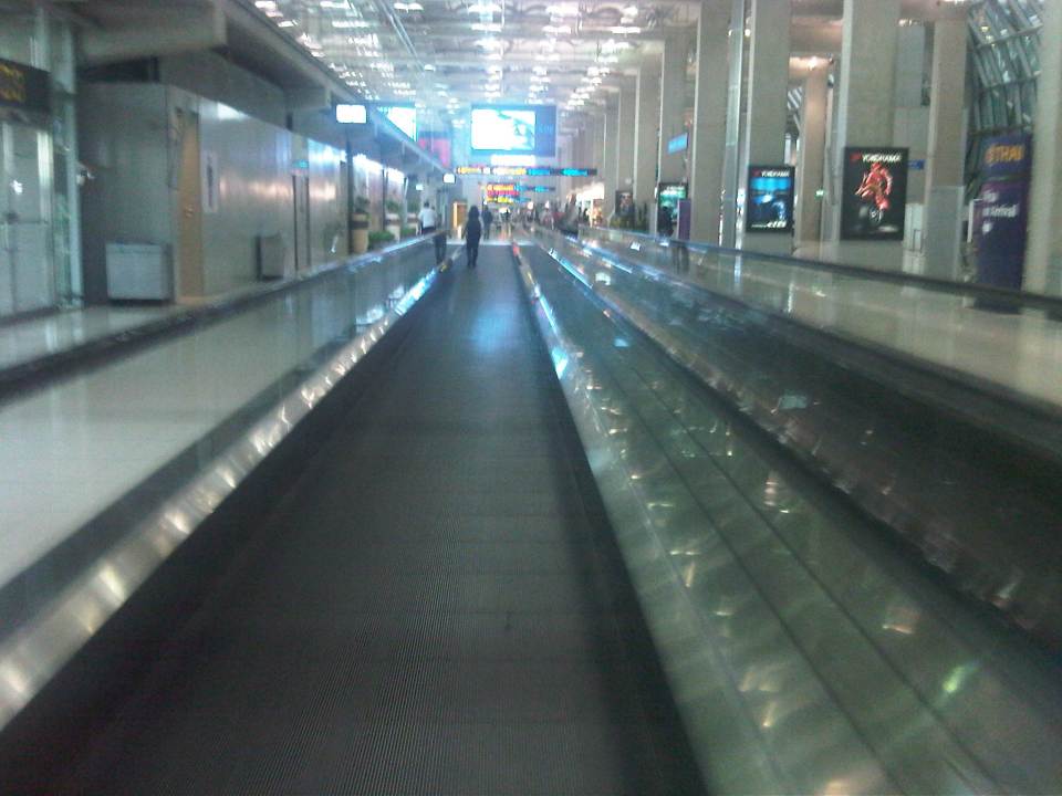
 Ready, get set, go? – Filipino overseas foreign workers (OFW) in transit to Dubai and other destinations via Bangkok seem to be rushing to their transfer flight using the moving walkway or “walkalator.”
 Long walks – the airport terminal is basically linear and moving inside the terminal would probably require one to use the many moving walkways especially if one is in a hurry to board or for a transfer.
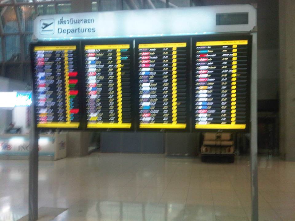 Departures – flight information board for departing aircraft
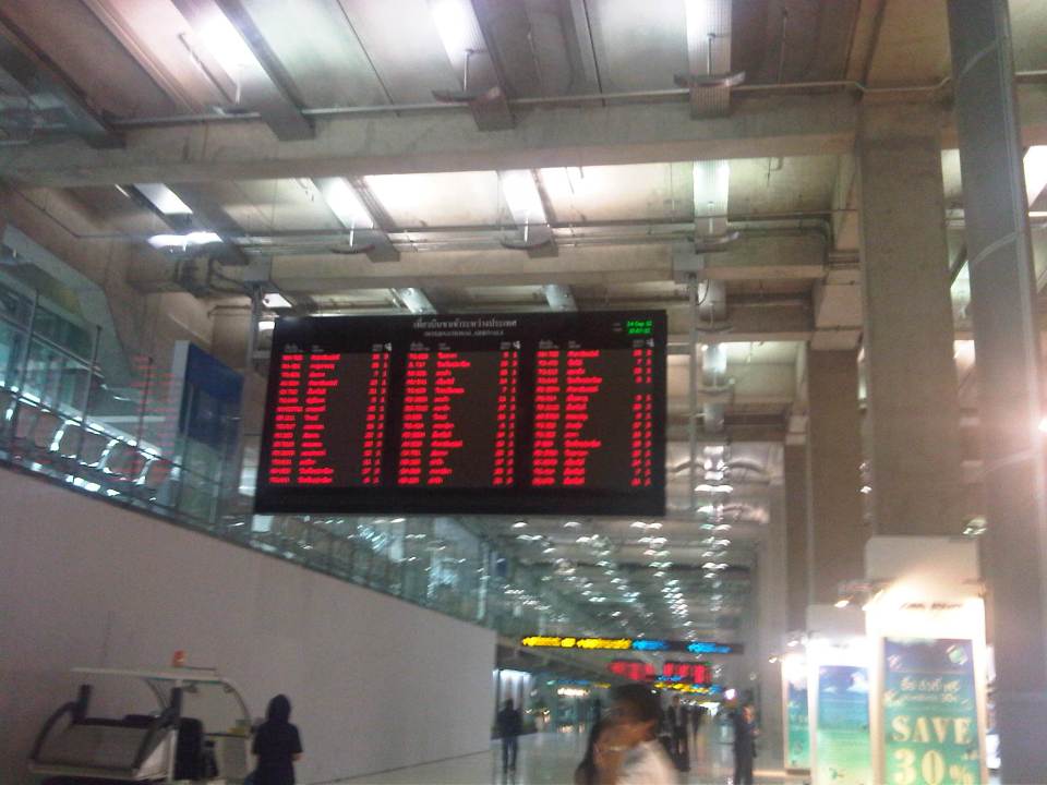 Can’t get enough of info – overhead electronic information boards for passengers can be quite useful for transfers or boarding information
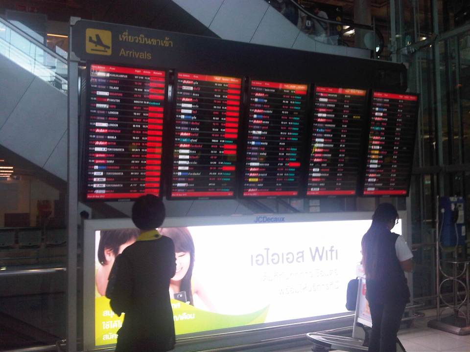 Arrivals – information board for arriving aircraft are useful to people picking up friends or clients.
 Airport concourse – the spacious airport terminal provides enough room for moving around. There are information booths for visitors/tourists as well as those catering to currency exchange, transport services, souvenirs, and snacks.
 Up and down – escalators and elevators are available for the convenience of airport users particularly when traveling to or from the rail link.
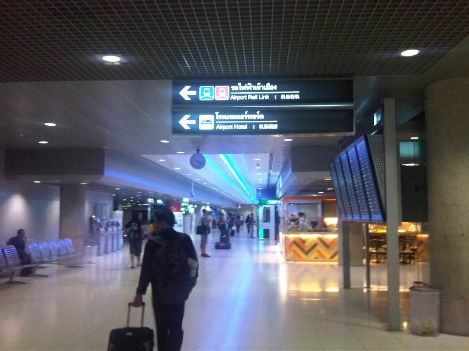 In transit within – heading to the airport rail link, travelers will be guided by the signs along the way.
 Airport rail link – ticket vending machine for the rail express link between the airport and the city center
I will post more photos later of the interior of the passenger terminal. There is not much difference between the terminal as I remember from the last time I was in Bangkok 5 years ago and this recent trip. This will be obvious in the next post on the airport.
–
Loss of productivity due to congestion and inefficient public transport
I recently read two articles appearing in a major Philippine daily and a popular online site. The first one is an article that appeared in the Philippine Daily Inquirer – “PH economy losing $3.27B in human productivity due to traffic mess” – last September 25, 2012. The other article was posted on Rappler – “Traffic and infrastructure delays cost the Philippines” – last September 27, 2012. These were articles written after the authors’ attendance of what was an Energy and Infrastructure Forum last Sept. 25 where a transport official mentioned a recent study in his talk that estimates productivity losses of about 3.27B USD per year from Metro Manila traffic alone.
 Traffic congestion along Commonwealth Avenue
 Unusual traffic management scheme along Ortigas Avenue
The study from the National Center for Transportation Studies that was mentioned in both articles was actually first featured in a Yahoo! Philippines article – “Traffic congestion costs Metro Manila P137B per year” – that appeared a month earlier in Aug. 28, 2012. The study being referred to is actually a paper presented by Dr. Jose Regin F. Regidor in his Professorial Chair lecture at the University of the Philippines Diliman’s College of Engineering Colloquium in early August 2012. A copy of the paper may be found below:
Prof Chair 2012 JRFR 02July2012
The main reference for this paper is the study on congestion costs that was produced by the National Center for Transportation Studies back in 2000. Credits go to the core team of Dr. Ricardo Sigua (Institute of Civil Engineering of UP Diliman), Dr. Noriel Tiglao (now with the National College of Public Administration and Governance) and Dr. Val Teodoro (now in the US) for the study. The
Economic Impacts of Traffic Congestion in Metro Manila – Cover+Chap 1 and 2
Economic Impacts of Traffic Congestion in Metro Manila – Chap 3
Economic Impacts of Traffic Congestion in Metro Manila – Chap 4 and 5
Economic Impacts of Traffic Congestion in Metro Manila – Appendix
A much needed update may be possible in the next two years once the traffic model for Metro Manila is updated and calibrated using new data from Household Informations Surveys (HIS) and other transport and traffic surveys under the current MUCEP study that is supported by the Japan International Cooperation Agency (JICA). Hopefully, such a model can be updated and calibrated more often in order to assess losses due to congestion and our continuing inability to provide the necessary infrastructure to alleviate the situation. While the paper and the study mentioned above focus on productivity losses, it should be emphasized that there are other costs that should be highlighted including those related to health (respiratory diseases and road crash fatalities and injuries), energy (fuel consumption and inefficiencies), and emissions (carbon and other GHG).
–
