
Home » Trip Generation (Page 3)
Category Archives: Trip Generation
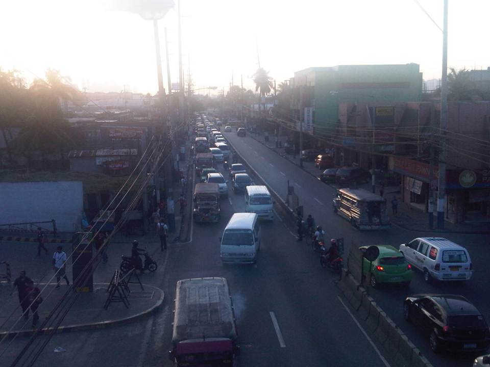
Shopping malls and Ortigas Avenue Extension traffic congestion
Recently, I noticed that traffic has somewhat eased along the eastbound side of Ortigas Avenue Extension. For one, this was probably due to the completion of road works and the reopening of lanes between Cainta Junction and Brookside. This improved traffic flow as traffic personnel didn’t have to resort to the balancing act that is the counter-flow scheme they had been employing to alleviate congestion for mostly home-bound traffic. But a major contributor to congestion was the Ever Gotesco Mall in the former Riverside industrial complex. Malls like this are major trip generators and if traffic coming in and out of the malls are not managed properly or facilities are not provided for efficient movement of people and vehicles, then there will surely be congestion along access roads. I stated that the Ever mall ‘was’ a major contributor because the mall recently closed down and the property is now fenced off from the road. At present, there is practically zero traffic that can be attributed to the former mall.
Following are a few photos of the closed and fenced off property that was the Ever Ortigas mall.
 Jeepneys and UV Express vehicles now use the service road of the mall as a terminal.
 It’s now a breeze passing through the eastbound section of Ortigas Extension in front of the former mall. There are signs stating the property has been acquired by retail giant SM. It will probably be transformed into an SM mall.
 This driveway used to cause congestion as jeepneys and private vehicles exited the mall through this driveway and many turned left towards Ortigas westbound. These vehicle often effectively blocked traffic along the eastbound direction with queues reaching all the way past Countryside and reaching De Castro on a bad day.
There were only two shopping malls along Ortigas Avenue Extension – the Robinson’s Place near Cainta Junction and Ever Gotesco. Ever has recently close but it is expected to re-open as an SM Mall sometime in the near future. SM doesn’t have a mall in the area and the ‘nearest’ ones would be Megamall, Marikina and Taytay (not counting the Super Center beside Tiendesitas and the Super Center along Felix Avenue). If indeed an SM mall will be there soon, we could expect heavier traffic in the area given the trip generation characteristics of SM. Perhaps, though, there is an opportunity to improve traffic in the area if SM can consider some improvements to its driveways and circulation. They could probably do something like what SM Novaliches had done with their generous setback to ensure that there will be no serious congestion along Quirino Avenue due to mall-generated traffic.
SM will not be the only major commercial development that is expected to generate traffic that will lead to congestion along Ortigas Extension. Almost across the former Ever mall is a commercial development under construction with a building I think is too close to the road. Then there is also the commercial/residential project that is being constructed along the westbound side of Ortigas Extension near the Kaytikling Junction in Taytay, Rizal. I wonder if these had the necessary traffic studies to support their impacts on at least the immediate areas they will be affecting.
–
EASTS 2015 – Cebu City, September 11-13, 2015
The 11th International Conference of the Eastern Asia Society for Transportation Studies (EASTS 2015) will be held in Cebu City this September 11-13, 2015. For information on the conference and program, check out their website here:
You can also download a brochure about EASTS here:
The conference is hosted by the Transportation Science Society of the Philippines (TSSP), which is the local affiliate of the EASTS. More information on the TSSP are found below:
–
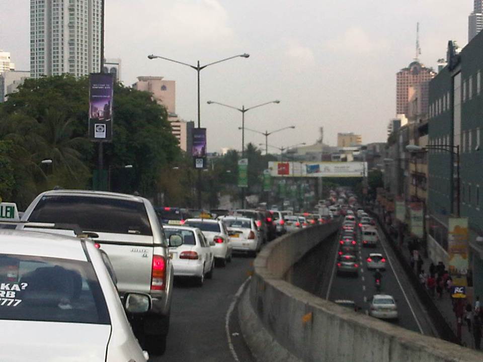
Ortigas Ave. Extension choke points
One alternative route for my daily commute is Ortigas Avenue. While there are several choke points along this road, I will focus on those between the Ever mall and Cainta Junction. Congestion is also usually experienced between the Manggahan Bridge and Ever but these are mostly due to traffic interruptions because of vehicles turning to and from the many subdivisions whose access/egress line up along Ortigas Ave.
The Ever mall is already a given as a significant traffic generator in the area. However, there is something about its circulation particularly the flow of vehicles in and out of the complex that detrimentally affects Ortigas Ave. traffic. While through traffic along the eastbound direction should use Ortigas Ave., many opt to go through the wide driveway of Ever in order to bypass the choke point that is the exit driveway of the mall. Many of these exiting vehicles are jeepneys turning left into Ortigas westbound (their routes terminate here and make their turnaround via Ever’s driveway). These effectively block the flow of traffic along Ortigas eastbound especially in cases when the westbound direction is also congested (i.e., due to sheer volume as well as stopping vehicles across the mall).
 Vehicles exiting from Ever and turning left to Ortigas westbound
Once eastbound vehicles are freed from the blockage of left-turning vehicles, they have to merge with significant right-turning traffic from Ever that includes buses and mostly through traffic vehicles whose drivers were ‘wise’ to have taken the driveway instead of Ortigas to get through the choke point. The situation results in another choke point right after the first one as the traffic along two lanes of Ortigas eastbound merge with the traffic equivalent to 2-3 lanes turning right from Ever. The total of 5 lanes of traffic squeezing into 2 lanes immediately after is a prime example of a bottleneck.
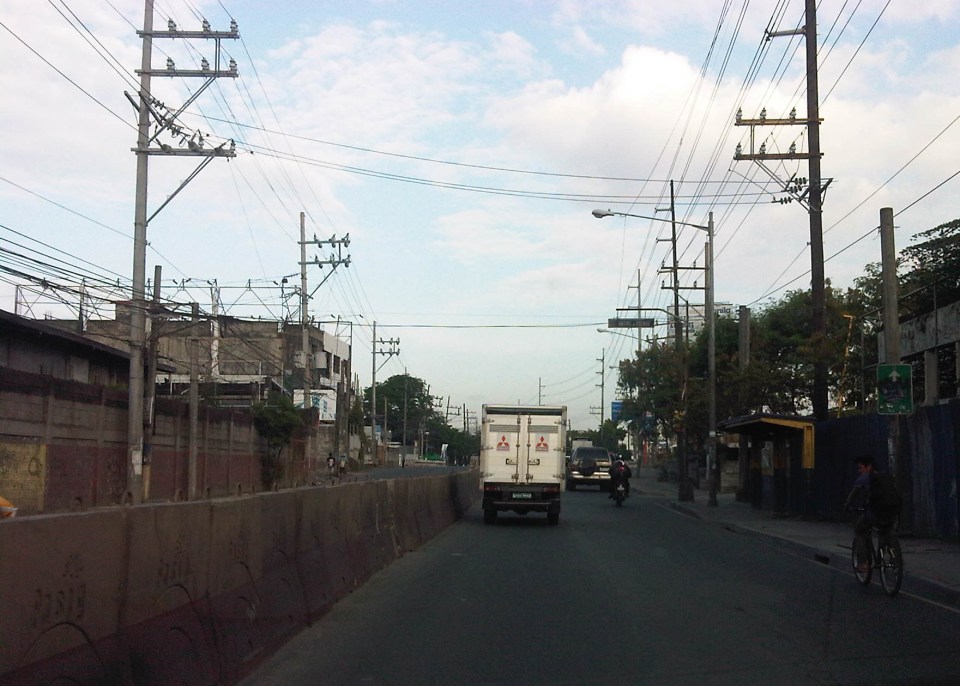 Narrow eastbound two-lane section – additional space should be expropriated to widen Ortigas at this section
Right after the short 2-lane section is a sudden widening of Ortigas Ave. in front of BF Metals. I have heard it said that this is the ideal road width for Ortigas Ave. considering the volume of traffic passing through this major corridor connecting Rizal province with Metro Manila. There are practically 4 lanes for each direction at this short section so its easy to project these lanes on maps to see what properties would need to be expropriated if the objective is road widening. (Of course, the best option should still be to pursue a mass transit system along this corridor.)
 Ideal road width – Ortigas Avenue at its widest is the section across BF Metals. Vehicles here spread out along the many lanes suddenly available. But then people will eventually and immediately realize this is the mouth of a funnel. Note the sign indicating that vehicles are entering the Province of Rizal from this point.
 The eastbound section in front of BF Metals is usually parking lot in the evenings. This is due mainly to the 4 lanes almost abruptly constricting into 2 lanes just past BF Metals. Compounding things is the U-turn slot located here where many jeepneys whose routes end at Cainta Junction make their turnaround. Turning vehicles are assisted by “tambays” earning their money by blocking eastbound vehicles to make way for U-turning vehicles.
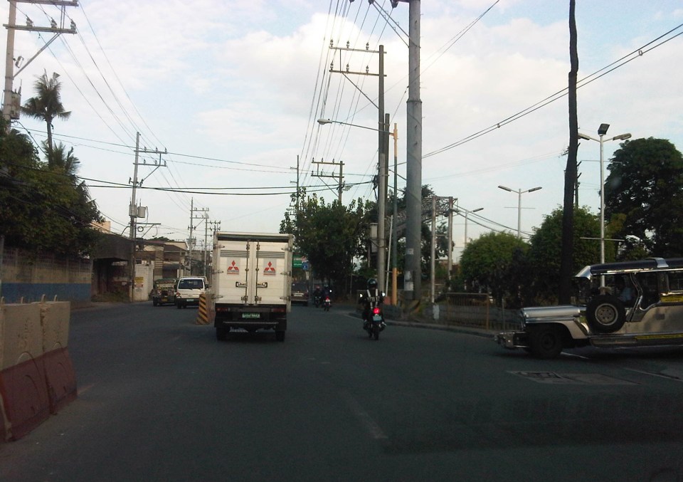
Finally, there is Cainta Junction itself, which is a signalized 4-leg intersection that handles a tremendous volume of traffic all-day. I am sure that there are efforts for the traffic signal settings to be optimized but more often there is human intervention for traffic management at the intersection. Whether this causes more severe congestion is quite obvious to many travelers going through this intersection. Queues along Imelda Ave./Felix Ave., for example, can reach way past Village East even reaching Vista Verde on a bad day. This only shows that the intersection is already severely saturated and conventional traffic management or signal settings can no longer handle the traffic. Perhaps the next stage of engineering intervention for this intersection is grade separation or the construction of a flyover or two at the intersection. Notably, such a project should including strategic widening along Ortigas Ave in order to balance the number of lanes feeding into and receiving traffic from the intersection.
 A view of the traffic approaching Cainta junction – there are only 2 lanes along the eastbound side of Ortigas and public utility vehicles stopping here only exacerbates the congestion along the road.
Is road widening the ultimate solution to Ortigas Ave congestion? I personally don’t think so. As I have mentioned earlier in this post and in previous posts the key is still to come up with a mass transit system to serve this eastern corridor. Yes, there will eventually be a Line 2 along Marcos Highway, the main alternate (or competing?) route to Ortigas but is is obvious that even with a railway line along Marcos Highway and connecting to Aurora Blvd., there will still be an urgent need for a similar capacity line along Ortigas. The buses and jeepneys can no longer handle the demand and their poor levels and qualities of service have given rise to a proliferation of UV Express and pushed people to purchase cars and motorcycles. Congestion can be reduced significantly with a mass transit system along Ortigas. Without this transit system, Ortigas will just continue to be congested even if the entire corridor is widened; except perhaps if it is widened like Commonwealth Ave. in Quezon City. I don’t think that is possible and practical.
–
On school trip generation and exclusive villages
In the news weeks ago is the coding scheme for vehicles that Ayala Alabang, a posh residential subdivision in Muntinlupa City, imposed on vehicles coming in and out of the village. According to media reports, affected are vehicles bound for and coming out of De La Salle Zobel (DLSZ), which is an exclusive school located inside the subdivision. There is another exclusive school inside the village but they don’t seem to be in the news regarding this issue on car stickers and access through the subdivision roads. Perhaps they generate a lot less cars from outside the village?
I lived in villages where there are exclusive schools also located inside the villages. They are smaller compared to DLSZ and likely generate significantly less vehicles than the latter. Also, the numbers of vehicles they generated from outside the subdivisions are not enough to cause traffic congestion along the main roads to and from the schools and the village gates.
For the school in the former subdivision we used to reside in, I noticed that most students arrived via school service. School service vehicles carry more passengers than private cars and so help reduce the number of vehicles generated by the school. These were mostly vans or AUVs and not the mini-buses, coasters or regular buses of when I was in grade school and high school myself. Though lower in capacity compared to buses, AUVs and vans could take in 10 to 12 students comfortably and perhaps max out at 14 to 16 people depending on the sizes of the children the ferry between school and their homes.
In the current subdivision where I live, most students go by car and the wider main road that they use translated to faster cars running between the village gate and the school. I have observed many instances when speeding vehicles do not slow down at intersections or when there are people about to cross the street. There are no humps along the main road like those in the previous village. Humps or speed bumps can be very effective in reducing speeds but improperly designed humps can eventually damage your car’s suspension. The rolling terrain of our village does not seem to be a deterrent against speeding and limited sight distances along the main road presents a significant likelihood that a crash can occur involving speeding vehicles. Thus, some traffic calming measures need to be formulated and implemented before tragedy strikes.
Now that school is almost out for most schools (including the ones inside subdivisions) I think the attention the issue has been getting will steadily die down. But that will be until schools open again in June and residents again feel the impacts of traffic generated by the schools from without the subdivision whether its traffic congestion or road safety that is the more pressing issue in residential subdivisions hosting schools. Perhaps a sticker system and the restriction of the number of vehicles of outsiders is one way to reduce the negative impacts of traffic generated and then there is also the option of not allowing a major school to be located inside a residential subdivision in the first place.
–
Transport and traffic purgatory, paradise and inferno
A lot of people have been referring to the traffic congestion and other derivative issues that will be the result of the construction of several transport projects around Metro Manila as “traffic armageddon.” Some friend have appropriately (I think) referred to it more as “car-mageddon.” This seems to be the case since it is perceived to have the most impact on car users than public transport users, cyclists or pedestrians. This is far from the truth as there are more people taking public transport, cycling or walking than those driving their own cars. In fact, estimates for Metro Manila indicate that 70-80% of travelers take public transport while 20-30% take private vehicles. These mode splits do not include bicycles or walking, which obviously will further decrease private car shares.
I would rather refer to this period of construction as a sort of “purgatory” though it has nothing to do with the cleansing that’s associated with it. There is still the suffering involved while improvements are being implemented. But, most importantly, there is hope at the end of this process. This “hope” is not necessarily the “light at the end of a dark tunnel” kind of thing as surely population and the number of vehicles will surely increase over time even as the transport projects are being implemented. By the time these are completed, there are sure to be more people, more vehicles, as well as more of other developments that will put our transport system to a stress test. We can only hope that the designs of these infrastructure we are building now are based on honest to goodness trip or traffic forecasts. Otherwise, we’ll end up with congested or saturated systems by the time they start operating.
Unfortunately, most projects mentioned and those we know have the green light and would likely be proceeding with construction in the near future are basically road projects. It’s ironic considering that what Metro Manila urgently, and maybe desperately, needs now are public transport systems including the much delayed MRT 7, LRT 2 Extension and LRT 1 Extension. The proposals for Bus Rapid Transit (BRT) seem to be in a limbo, too, despite extensive studies and surveys to support BRT along corridors such as Ortigas Avenue and Circumferential Road 5. These are blamed on institutional and legal impediments including allegations of shortcomings among officials of agencies responsible for these infrastructure.
I am aware of an initiative led by an environmental lawyer seeking to effect the redistribution of road space in favor of public transport users, cyclists and pedestrians. I think such actions are useful from the perspective of getting the attention necessary to push government and private sector players to have a sense of urgency not just in words but also in actions in as far as transport infrastructure programs and projects are concerned. We are already lagging behind our ASEAN neighbors with regards to infrastructure and at this pace, it is likely that less developed countries like Cambodia and Myanmar might just overtake us in the foreseeable future. From another perspective, it is hard to push for sharing the road when people really don’t have better options for commuting. Walking and cycling are not for everyone and many people have turned to the motorcycle to solve their transport woes. In the latter case, motorcycles are perceived as a vehicle that’s fuel efficient and allows the users to zip through congested streets often at high risks of being involved in a crash or spill.
We can only achieve “paradise” in our highly urbanized cities if we build these mass transit systems along with the pedestrian and cycling facilities that will complement each other. Those for whom car travel is a necessity would also benefit from reduced road congestion so it will eventually (hopefully) play out well for most people. Meanwhile, we would have to endure transport and traffic hell (some more and longer than others) as the government and private sector embark on this round of infrastructure projects implementation. It helps to look back at our experiences with the last major batch of projects in the latter part of the 1990’s when the number coding scheme was first implemented. At the time, it was implemented as a temporary measure to alleviate congestion while projects where being implemented. What was a temporary measure is now still being implemented along with a truck ban that has also been evolving the past years with the latest being the one implemented by the City of Manila starting last February 24. Will these vehicle restraint schemes be modified to cope with the traffic congestion expected from projects like the Skyway connector? Will these be relaxed or removed after all these projects have been completed? Your guess is as good as mine.
–
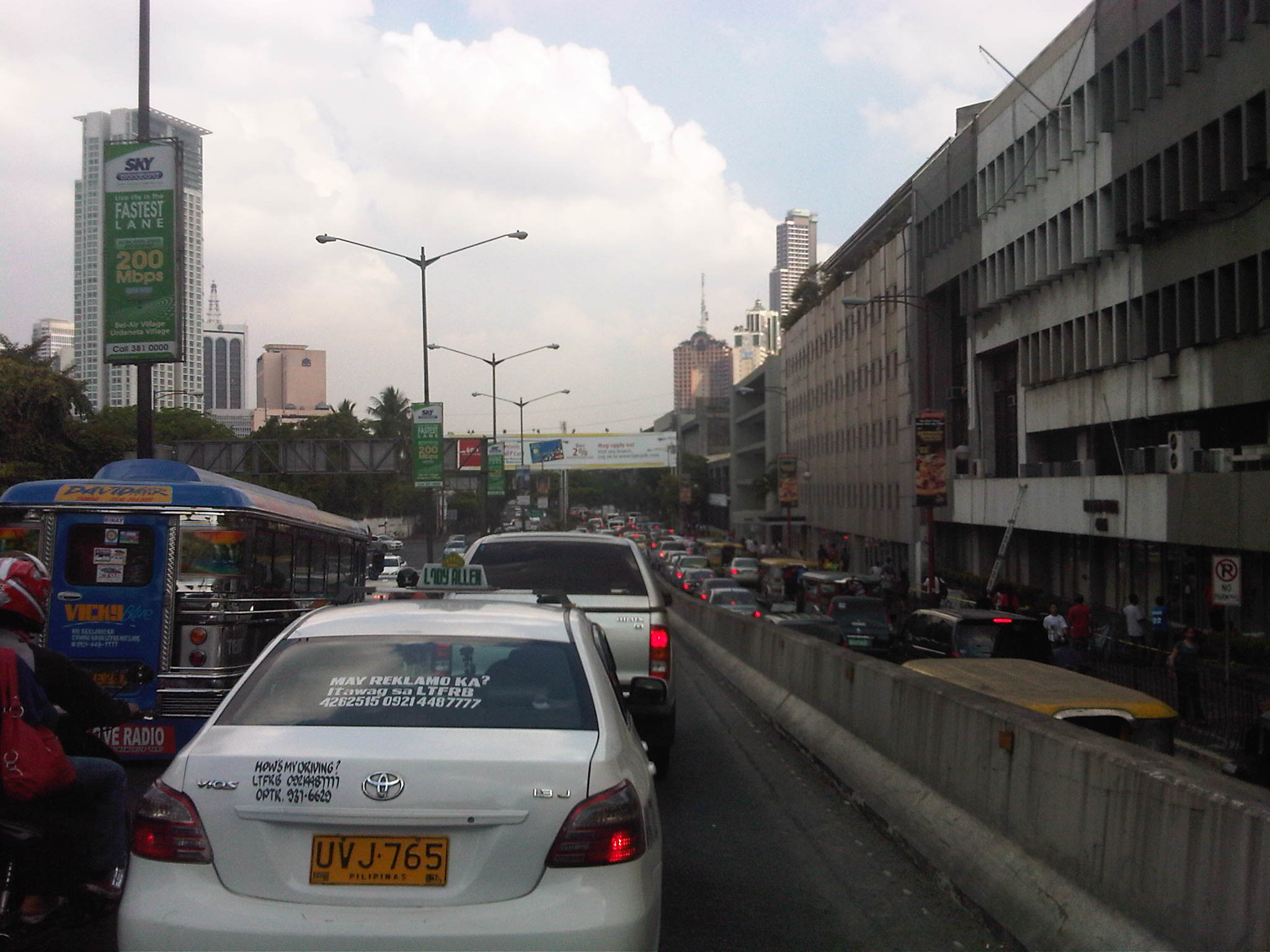
Traffic congestion along Buendia (Gil Puyat Ave.)
The Makati CBD generates a very high number of trips owing to it being arguably the largest CBD in Metro Manila in terms of offices and workers. There are several other CBDs like Manila, Ortigas, Cubao, Eastwood, Filinvest City, and Bonifacio but they generate less traffic compared to Makati. There are several major roads in the area including four intersecting roads that practically define the CBD. These are Ayala Avenue, Gil Puyat Avenue (formerly but still popularly known as Buendia Avenue), Makati Avenue and Paseo de Roxas. Both Gil Puyat and Ayala Avenue are lined with offices along either side and are often congested due to the vehicle traffic generated by the CBD. Following are a few photos of Buendia Ave.
 Traffic congestion along Gil Puyat Ave. as seen from the overpass from Kalayaan Ave. Even the sidewalk on the right side of the road is filled with pedestrians.
 One can see many people walking along the narrow sidewalk along Buendia. Some buildings have been renovated and refitted but many remain as they were in the last decade or more. The building in the center of the photo has so many air-conditioning units jutting outside the windows that it is quite obvious the units were an afterthought. Other buildings would likely have centralized or more strategically positioned air-conditioning units.
 Another look at the traffic jam along one of Makati’s main roads indicate a lengthy queue from the Buendia Ave.-Paseo De Roxas intersection. The junction is signalized but saturated during peak periods. I am not sure about the optimization of the signal settings but it should be synchronized with at least two other intersections: Buendia Ave.-Makati Ave. and Paseo de Roxas-Makati Ave.
The DPWH is proposing a grade separation project along Buendia that is supposed to alleviate congestion at the intersections with Paseo de Roxas and Makati Avenue. The plan is to have an underpass along the avenue that would allow vehicles to flow through and bypassing the two major intersections. At-grade would still be signalized intersections but minus substantial through traffic along Buendia. The downside of such a project, of course, would be the expected traffic congestion during the construction phase. With very limited alternate routes and restricted space (i.e., unlike the case of the Quezon Ave. underpass at Araneta Ave.), traffic management in the area will surely be a challenge for the combined forces of Makati and MMDA traffic enforcers.
–
What Public Transit Data Teaches Us About How People Use a City
I’m sharing an interesting article featured on The Atlantic Cities, one of our favorite sites on the internet. Enjoy!
What Public Transit Data Teaches Us About How People Use a City.
Parking issues in the Philippines
Saw this report from the GMA News YouTube channel that appeared in several of their news programs in Channels 7 and 11. It’s a good report as it is informative and the reporter did sufficient research on parking provisions stipulated in the Philippines’ National Building Code. I also found it interesting that one mall in Manila is already using an automated parking facility such as the one shown in the report. These multilevel parking facilities maximize the space required for slots and do not require much space for ramps or driveways. They are already found in cities in many other countries and should be considered in many other cities in the Philippines that are now facing parking problems.
Establishments such as shopping malls and other commercial areas are significant traffic generators. One aspect of trip generation is parking generation, and malls attract many people who tend to use private vehicles as their means for travel. This is especially true in Metro Manila and other major cities in the country where there are limited choices for public transport. For one, it is not so convenient nor comfortable for people taking public transport in Metro Manila. And so, a lot of people would bring their cars or motorcycles for shopping trips.
There is little information or data on parking generation characteristics in the country and it is unclear if the National Building Code’s provisions are sufficient. The NBC’s prescribes the number of minimum parking spaces for establishments but these are already being violated by many, which brings us to question the manner by which authorities approve designs for buildings given this requirement for parking.
–
Another look at Imelda Avenue traffic
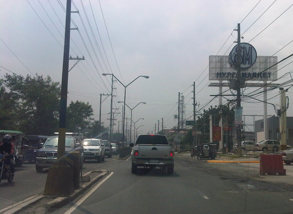
A reader brought to my attention some traffic problems encountered along a section of Imelda Avenue in the vicinity of a major retail chain’s branch. There are experiences of traffic congestion along the section fronting the SM Hypermarket from across the Village East subdivision. However, the commercial development and the traffic generated is not really new since the hypermarket replaced another similar establishment (Makro). Arguably though, the trip generation rates of SM developments can be higher than their competitors considering their branding and customer preferences based on traffic experience around SM malls. Following are some specific observations and comments for the case of Imelda Ave. in the vicinity of the SM Hypermarket along the highway.
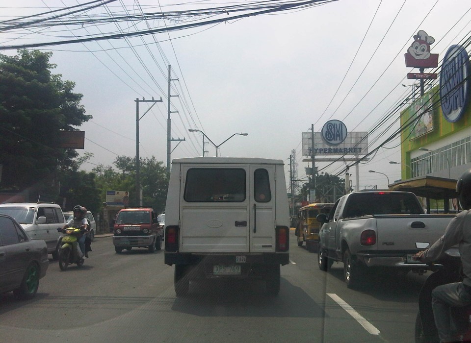 Slow-moving traffic in front of the SM Hypermarket along Imelda Avenue in Cainta, Rizal
 Congestion in the previous photo turned out to be caused by jeepneys loading and unloading passengers in front of the commercial development. Jeepneys tend to occupy the outer lane of the highway, significantly reducing road capacity thereby causing a bottleneck leading to congestion propagating upstream. There is actually a loading/unloading bay on the Hypermarket side of the road but jeepneys do not use this and almost always stop in the middle of the road.
 There are also tricycles using Imelda Ave. despite the regulations prohibiting them from national roads. The tricycles serve the residential subdivisions along the highway but used to be the main mode of transport along an unfinished Imelda Ave. from the 1970’s and competed directly with the jeepneys from the 1980’s one the connection between Ortigas Ave. and Marcos Highway had been made, leading to the opening of new jeepney routes through Imelda Avenue.
 The bottleneck for this section is along both directions as jeepneys stop not only for the Hypermarket but also for the residential subdivision (Village East) that is located just across from SM. The gate of the village opens toward SM with traffic generated significant enough to create a 3-leg intersection at the subdivision access/egress. This is an unsignalized intersection that has no enforcer to manage traffic, leaving it up to the motorists to determine acceptable gaps for conflicting movements. Compounding the situation are pedestrians crossing just about anywhere along the road like the people shown in the photo above.
The issues mentioned above are not all unique to the location but are often the case for many other places where there are major traffic generators such as malls, supermarkets and even residential developments. In fact, middle class villages are major traffic generators due to the car ownership but they are usually predictable in terms of peak periods. That is, the morning and afternoon/evening peak are well-defined according to office or school hours associated with residents (i.e., “to school,” “to work,” and “to home” trips). The solution, of course, is quite basic though not so simple – traffic management in the form of personnel who will enforce traffic and manage intersection flow. It is basic because it is a solution that’s definitely “in the box” and traditional or conventional. It is not simple because often, there is a lack of qualified personnel who can manage traffic full-time, and competent to firmly enforce traffic rules and regulations in order to effect behavioral change (for the better) among motorists and pedestrians. Granted, the commercial development should take the initiative to manage traffic and these may be recommendations already made when a traffic/transport impact assessment was conducted prior to the construction of the Hypermarket. Such assessments should have included traffic forecasting (estimating future traffic) in order to determine potential traffic congestion in the area and the formulation of site specific and appropriate mitigation measures. Perhaps there is a document somewhere (EMB?) that Cainta may use as a guide for how to address transport and traffic problems in the area due to the presence of the supermarket. If none, then the burden will be on the local government to study the traffic and come up with a strategy on how to lessen the detrimental traffic impacts of development in the area.
–
Some thoughts on transport and traffic while commuting between Cainta and Antipolo
Commuting from the Ortigas (Cainta) end of Imelda Ave. to its other end at Marcos Highway (near where Pasig, Marikina, Cainta and Antipolo meet), one should be able to observe and make a quick assessment of the positives and negatives of our local transport system. While there are more negatives at Cainta Junction and along Imelda Avenue, Marcos Highway definitely has improved particularly in terms of walkability. It is a commute that I have taken so many times since my childhood days and I can only now remember times when one could walk safely from one end to the other when there were far less vehicles than the volume that flows along Imelda Ave. these days.
Junction is still quite the mess despite some road widening at the intersection owing to various factors including the fact that the intersection simply cannot handle the volume of vehicles using it even after the elimination of some turning movements from Ortigas Ave. in favor of U-turns particularly for traffic coming from the eastbound side of Ortigas. It seems the traffic signal settings can no longer handle peak period traffic and manual traffic management probably aggravates the situation especially when enforcers employ the buhos technique of trying to dissipate as much of the queued vehicles per approach or movement. The latter technique does not take into consideration that the longer a movement or group of movements are allowed to move, there are corresponding build-ups in traffic along all other approaches. It is a vicious cycle (pun intended) that is supposed to be addressed by an optimally times signal system. Saturated conditions, though, are inevitable due to the sheer volume of vehicles using the intersection given that Junction is a catchment for vehicles from Rizal Province that ultimately uses Ortigas Ave. to head into Metro Manila in the mornings. The reverse is true in the afternoon to evening periods.
Imelda Avenue, which was also known for a time as Francisco Felix Ave., is plagued congestion due to notoriously bad pavement conditions, so many median openings, and high vehicle trip generation rates from the many residential subdivisions or village along the road. The pavement conditions are due mainly to damage brought about by trucks and, during the wet season, frequent flooding along many sections of the avenue. Bad pavement conditions and flooded streets significantly slow down traffic as Imelda Ave only has two lanes along each direction and is divided by a narrow median island that’s just enough for a few plant boxes and lamp posts.
There are mostly middle class subdivisions including the large Vista Verde, Village East, Karangalan, and Pasig and Cainta Green Parks along the road. There is also a DMCI medium rise development has its main access road also connecting to Imelda Ave. These villages generate much vehicle traffic and each have their own median openings that practically function as intersections along the entire stretch of the avenue. These openings create a lot of conflict between through traffic and vehicles entering and exiting the villages, especially those taking left turns to or from their gates.
While there are commercial establishments along the avenue, most were small and traffic generation characteristics were not so significant as to cause severe congestion. The first major generator in the middle of the avenue was a branch of the membership-concept Makro supermarket cum depot. Makro generated significant traffic but did not cause much congestion along the stretch in front of the Village East gate. It was eventually acquired by commercial giant SM and the branch is now an SM Supercenter that seems to be generating much more traffic than Makro did at its peak. While traffic studies are usually the norm before such developments are constructed given the trips attracted by SM, the congestion experienced along Imelda Ave has been reported to be generally un-managed despite the need for more disciplined loading and unloading by public transport, pedestrian movements and vehicle entries and exits.
Jeepneys are the main public transport mode along Imelda Ave. although there are tricycles serving the various subdivisions that often not only cross the road but also travel along Imelda Ave. for short distances. I remember in the 1970’s and early 80’s that the tricycles used to be the primary mode of transport from Junction and the Cainta Public Market as Imelda was not yet connected to the still to be completed and unpaved Marcos Highway. There was even a Metro Manila Transit Corp. bus service (probably missionary route and with low frequency of service) along Imelda Ave. that turned around near Kasibulan Village, one of the first subdivisions in the area. Many jeepneys are noticeably the patok or popular type known for their loud stereos and reckless driving. Still, there are the smaller, older jeepneys whose route connects either ends of Imelda Avenue. Most patok jeepneys are from the many longer routes between Rizal towns and Cubao overlapping along Imelda Ave (e.g., Angono-Cubao, Antipolo-Cubao, Binangonan-Cubao, Taytay-Cubao, etc.).
–
