
Home » Trip Generation (Page 4)
Category Archives: Trip Generation
Parking issues in the Philippines
Saw this report from the GMA News YouTube channel that appeared in several of their news programs in Channels 7 and 11. It’s a good report as it is informative and the reporter did sufficient research on parking provisions stipulated in the Philippines’ National Building Code. I also found it interesting that one mall in Manila is already using an automated parking facility such as the one shown in the report. These multilevel parking facilities maximize the space required for slots and do not require much space for ramps or driveways. They are already found in cities in many other countries and should be considered in many other cities in the Philippines that are now facing parking problems.
Establishments such as shopping malls and other commercial areas are significant traffic generators. One aspect of trip generation is parking generation, and malls attract many people who tend to use private vehicles as their means for travel. This is especially true in Metro Manila and other major cities in the country where there are limited choices for public transport. For one, it is not so convenient nor comfortable for people taking public transport in Metro Manila. And so, a lot of people would bring their cars or motorcycles for shopping trips.
There is little information or data on parking generation characteristics in the country and it is unclear if the National Building Code’s provisions are sufficient. The NBC’s prescribes the number of minimum parking spaces for establishments but these are already being violated by many, which brings us to question the manner by which authorities approve designs for buildings given this requirement for parking.
–
Another look at Imelda Avenue traffic
A reader brought to my attention some traffic problems encountered along a section of Imelda Avenue in the vicinity of a major retail chain’s branch. There are experiences of traffic congestion along the section fronting the SM Hypermarket from across the Village East subdivision. However, the commercial development and the traffic generated is not really new since the hypermarket replaced another similar establishment (Makro). Arguably though, the trip generation rates of SM developments can be higher than their competitors considering their branding and customer preferences based on traffic experience around SM malls. Following are some specific observations and comments for the case of Imelda Ave. in the vicinity of the SM Hypermarket along the highway.
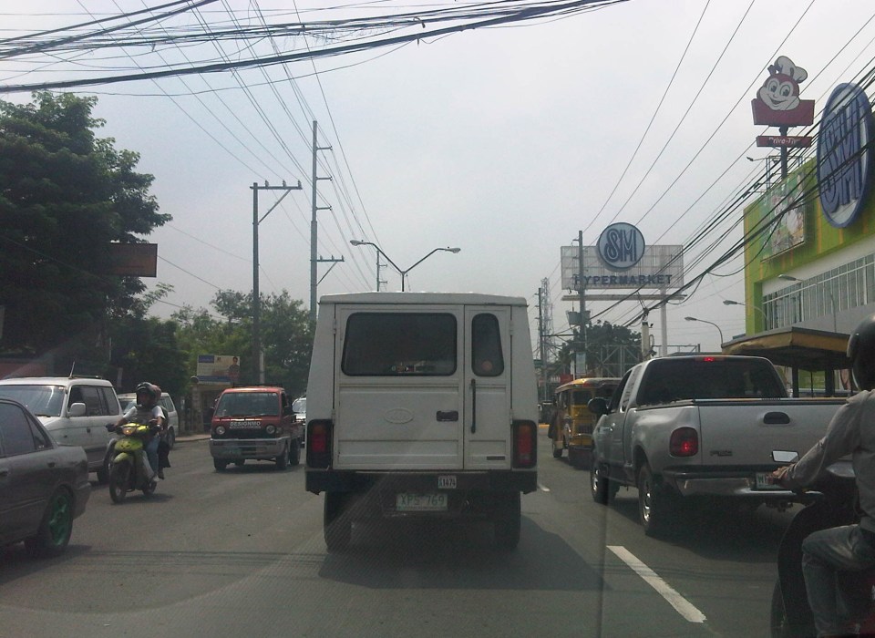 Slow-moving traffic in front of the SM Hypermarket along Imelda Avenue in Cainta, Rizal
 Congestion in the previous photo turned out to be caused by jeepneys loading and unloading passengers in front of the commercial development. Jeepneys tend to occupy the outer lane of the highway, significantly reducing road capacity thereby causing a bottleneck leading to congestion propagating upstream. There is actually a loading/unloading bay on the Hypermarket side of the road but jeepneys do not use this and almost always stop in the middle of the road.
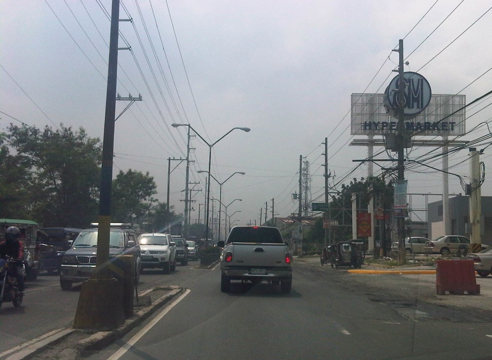
 There are also tricycles using Imelda Ave. despite the regulations prohibiting them from national roads. The tricycles serve the residential subdivisions along the highway but used to be the main mode of transport along an unfinished Imelda Ave. from the 1970’s and competed directly with the jeepneys from the 1980’s one the connection between Ortigas Ave. and Marcos Highway had been made, leading to the opening of new jeepney routes through Imelda Avenue.
 The bottleneck for this section is along both directions as jeepneys stop not only for the Hypermarket but also for the residential subdivision (Village East) that is located just across from SM. The gate of the village opens toward SM with traffic generated significant enough to create a 3-leg intersection at the subdivision access/egress. This is an unsignalized intersection that has no enforcer to manage traffic, leaving it up to the motorists to determine acceptable gaps for conflicting movements. Compounding the situation are pedestrians crossing just about anywhere along the road like the people shown in the photo above.
The issues mentioned above are not all unique to the location but are often the case for many other places where there are major traffic generators such as malls, supermarkets and even residential developments. In fact, middle class villages are major traffic generators due to the car ownership but they are usually predictable in terms of peak periods. That is, the morning and afternoon/evening peak are well-defined according to office or school hours associated with residents (i.e., “to school,” “to work,” and “to home” trips). The solution, of course, is quite basic though not so simple – traffic management in the form of personnel who will enforce traffic and manage intersection flow. It is basic because it is a solution that’s definitely “in the box” and traditional or conventional. It is not simple because often, there is a lack of qualified personnel who can manage traffic full-time, and competent to firmly enforce traffic rules and regulations in order to effect behavioral change (for the better) among motorists and pedestrians. Granted, the commercial development should take the initiative to manage traffic and these may be recommendations already made when a traffic/transport impact assessment was conducted prior to the construction of the Hypermarket. Such assessments should have included traffic forecasting (estimating future traffic) in order to determine potential traffic congestion in the area and the formulation of site specific and appropriate mitigation measures. Perhaps there is a document somewhere (EMB?) that Cainta may use as a guide for how to address transport and traffic problems in the area due to the presence of the supermarket. If none, then the burden will be on the local government to study the traffic and come up with a strategy on how to lessen the detrimental traffic impacts of development in the area.
–
Some thoughts on transport and traffic while commuting between Cainta and Antipolo
Commuting from the Ortigas (Cainta) end of Imelda Ave. to its other end at Marcos Highway (near where Pasig, Marikina, Cainta and Antipolo meet), one should be able to observe and make a quick assessment of the positives and negatives of our local transport system. While there are more negatives at Cainta Junction and along Imelda Avenue, Marcos Highway definitely has improved particularly in terms of walkability. It is a commute that I have taken so many times since my childhood days and I can only now remember times when one could walk safely from one end to the other when there were far less vehicles than the volume that flows along Imelda Ave. these days.
Junction is still quite the mess despite some road widening at the intersection owing to various factors including the fact that the intersection simply cannot handle the volume of vehicles using it even after the elimination of some turning movements from Ortigas Ave. in favor of U-turns particularly for traffic coming from the eastbound side of Ortigas. It seems the traffic signal settings can no longer handle peak period traffic and manual traffic management probably aggravates the situation especially when enforcers employ the buhos technique of trying to dissipate as much of the queued vehicles per approach or movement. The latter technique does not take into consideration that the longer a movement or group of movements are allowed to move, there are corresponding build-ups in traffic along all other approaches. It is a vicious cycle (pun intended) that is supposed to be addressed by an optimally times signal system. Saturated conditions, though, are inevitable due to the sheer volume of vehicles using the intersection given that Junction is a catchment for vehicles from Rizal Province that ultimately uses Ortigas Ave. to head into Metro Manila in the mornings. The reverse is true in the afternoon to evening periods.
Imelda Avenue, which was also known for a time as Francisco Felix Ave., is plagued congestion due to notoriously bad pavement conditions, so many median openings, and high vehicle trip generation rates from the many residential subdivisions or village along the road. The pavement conditions are due mainly to damage brought about by trucks and, during the wet season, frequent flooding along many sections of the avenue. Bad pavement conditions and flooded streets significantly slow down traffic as Imelda Ave only has two lanes along each direction and is divided by a narrow median island that’s just enough for a few plant boxes and lamp posts.
There are mostly middle class subdivisions including the large Vista Verde, Village East, Karangalan, and Pasig and Cainta Green Parks along the road. There is also a DMCI medium rise development has its main access road also connecting to Imelda Ave. These villages generate much vehicle traffic and each have their own median openings that practically function as intersections along the entire stretch of the avenue. These openings create a lot of conflict between through traffic and vehicles entering and exiting the villages, especially those taking left turns to or from their gates.
While there are commercial establishments along the avenue, most were small and traffic generation characteristics were not so significant as to cause severe congestion. The first major generator in the middle of the avenue was a branch of the membership-concept Makro supermarket cum depot. Makro generated significant traffic but did not cause much congestion along the stretch in front of the Village East gate. It was eventually acquired by commercial giant SM and the branch is now an SM Supercenter that seems to be generating much more traffic than Makro did at its peak. While traffic studies are usually the norm before such developments are constructed given the trips attracted by SM, the congestion experienced along Imelda Ave has been reported to be generally un-managed despite the need for more disciplined loading and unloading by public transport, pedestrian movements and vehicle entries and exits.
Jeepneys are the main public transport mode along Imelda Ave. although there are tricycles serving the various subdivisions that often not only cross the road but also travel along Imelda Ave. for short distances. I remember in the 1970’s and early 80’s that the tricycles used to be the primary mode of transport from Junction and the Cainta Public Market as Imelda was not yet connected to the still to be completed and unpaved Marcos Highway. There was even a Metro Manila Transit Corp. bus service (probably missionary route and with low frequency of service) along Imelda Ave. that turned around near Kasibulan Village, one of the first subdivisions in the area. Many jeepneys are noticeably the patok or popular type known for their loud stereos and reckless driving. Still, there are the smaller, older jeepneys whose route connects either ends of Imelda Avenue. Most patok jeepneys are from the many longer routes between Rizal towns and Cubao overlapping along Imelda Ave (e.g., Angono-Cubao, Antipolo-Cubao, Binangonan-Cubao, Taytay-Cubao, etc.).
–
Predictability of school-generated traffic congestion
I have written about schools generating much traffic. The same characteristics of trip generation make congestion along streets affected by the schools quite predictable. For example, traffic congestion due primarily to the trip generation characteristics of schools along Katipunan Ave. may be observed during 6:30 – 7:30 AM as well as around 3:30 – 4:30 PM. The afternoon congestion though is exacerbated by the presence of significant truck traffic using C5 as part of their routes. Other cases would have similar predictability and I pointed this out to some guests while we were having a coffee break from our day-long meetings. The following photos were taken in the mid-afternoon and shows congestion along Ortigas Avenue in Mandaluyong City, including along an overpass affected by school traffic generation from a private school (the school is the one with the dome in the photo). Traffic is typically bad between 3:20 to 4:30 PM, after which it subsides until after 5:30 when the afternoon to evening rush from workplaces to homes take over much of the road space.
 View of the EDSA-Ortigas intersection showing the start of the build-up of traffic along the left turn overpass to Greenhills on the left side of the photo.
 View of the same flyover at around 3:36 PM. Note the long queue along both lanes of the overpass.
 View of traffic congestion from the 16F of the building hosting the headquarters of the Department of Transportation and Communications. The overpass featured in the preceding photos is shown with vehicles descending to merge with Ortigas Avenue traffic. Both directions of Ortigas Ave. are congested.
 Congestion as seen from the street level. Vehicles descending the overpass are generally bound for San Juan while those on the foreground are bound for the EDSA-Ortigas intersection. Long queues are likely caused by a combination of high traffic volumes and non-optimal green time management at the intersection.
 Another view of the congestion at both ground and overpass levels. Traffic is really bad when you have ambulant vendors walking along the overpass to sell their wares (e.g., cigarettes, candies, water, etc.) like what the man on the overpass near the van is doing.
Given the predictability of traffic congestion along this road, many motorists who have a choice or alternate route they can take avoid this road during such periods. Unfortunately, those taking public transport cannot avoid the congestion with passengers thereby incurring delays equivalent to wasted time. Most trips generated by such schools take private vehicles often having low occupancies (e.g., a driver plus a student = 2 passengers per vehicle). Perhaps schools should offer better school services/buses for their students? Or maybe there is a public transport option to be explored here? One thing is for sure and that is people at a young age learn that having cars is better than commuting. Such thinking is eventually carried over to when the same children become adults and an orientation favoring cars over public transport or even walking or cycling that they will eventually pass on to their own children, and so on. Perhaps our schools are in a very good position to influence the developing minds of their students and be responsible in promoting sustainable transport to their students.
–
School traffic impacts – issues along Ortigas Ave., Part 2
I had written recently about traffic congestion along Ortigas Avenue that is due mainly to traffic generated by a private school in the area. In the previous post, the photos only show vehicles parked on the sidewalks on either side of the road. They did not show the actual traffic congestion experience. The parked vehicles seem more incidental and indirect than concrete evidence of congestion brought about by school traffic generation though they are a definite manifestations of parking generation, which is directly related to traffic generation.
 Parked vehicles on the sidewalk are seen as we approached the tail of a very slow moving platoon owing to the congestion generated by an exclusive school.
 Traffic jam with road capacity reduced by the parked and standing vehicles along the EDSA-bound side of Ortigas Ave. The trees are witnesses to the chronic traffic jams and help alleviate their impacts by absorbing emissions from the vehicle.
 Severe congestion as we approached the school – the overpass downstream in the photo is a reference for where the school is located
 The overpass bears the name of the mayor of Mandaluyong City, where this school is located and which has jurisdiction, together with the MMDA, for traffic management in the area. At the time we passed the area though, there were no enforcers in the area despite the severe congestion. Is this because they gave the responsibility (or burden) of managing traffic to the school? Perhaps there was no need to post enforcers here as congestion is a regular thing and people seem to have been conditioned with the almost daily experience.
 The area at the foot of the pedestrian overpass actually functions as a pick-up and drop-off area for students of the school. As such, vehicles occupy not just the the sidewalk but also more than a lane of Ortigas Avenue. This effectively constricts traffic along this major road.
 Traffic is slow along the San Juan-bound direction of Ortigas as vehicles waiting for their passengers (students of the school) are lined up and occupying the outermost and even the middle lane of the road.
 This queue is not entirely attributed to traffic generation by the school but is likely due to traffic management at the EDSA-Ortigas intersection, which is signalized. If the signal setting is not optimized or if the intersection is not cleared of straggler vehicles, traffic is backed up along all the approaches to the intersection. The tall building in the background hosts DOTC’s headquarters. I wonder if our officials are taking in the congestion that occurs almost daily (weekdays) and if they are even crosses their minds how to solve this problem and others like it around the country.
 Proof that congestion is along both directions of Ortigas Ave. is seen in the middle of the photo where vehicles are also backed up along the overpass ramp coming from EDSA’s northbound side. For what it’s worth, the DOTC headquarters is right along this road at the building where the 7-Eleven (sign visible in the photo) is located.
 Another and even closer look of what is literally bumper-to-bumper traffic along both sides of Ortigas Avenue during the afternoon peak triggered by the exclusive school along its San Juan-bound side. Visible in the photo is the congestion along the overpass from EDSA.
–
School traffic impacts – issues along Ortigas Ave., Part 1
I have written about school traffic generation in this blog and have mentioned about the traffic congestion experiences along major thoroughfares due to the vehicles attracted by private schools. La Salle Greenhills (LSGH) is an exclusive school found along Ortigas Avenue and during the summer months of April and May, people passing through the stretch of the road from EDSA to the Greenhills Shopping Center are relieved that they won’t have to go through traffic jams due to the school-generated traffic. From June to early December and January to March, however, the area is almost always congested in the morning and afternoon. Such congestion is predictable since it occurs during a period when students come to school and when they are dismissed mid-day or in the afternoon.
Heading to a meeting at the DOTC from the University one morning, we decided to take an alternate route. Instead of EDSA or C5, we took East Ave., Tomas Morato Ave., Gilmore Street and then emerged at the westernmost end of Ortigas in San Juan. It was already 9:00 AM when we arrived at the section most affected by the traffic generated by LSGH and so we didn’t to get caught in a jam as we proceeded towards our destination. We were proven right as traffic was almost free-flowing, and I took advantage of the traffic conditions and to take a few photos of the indicators for the potential traffic congestion in the area. The following photos also show a serious parking problem and (sadly) the usurpation of space from pedestrians. For shame!
 School service vehicles parked along the sidewalk along Ortigas Avenue – beyond the wall on the right is Wack-wack, a high-end residential subdivision named for the sound of golf clubs swinging at its famous course.
 Private vehicles parked along the same sidewalk – noticeable in the photo is the pink line drawn by the MMDA to supposedly demarcate space that should not be obstructed and instead allocated for pedestrian use. It is clear in the photos that pedestrians would have to walk along the edge of the sidewalk or the outer lane of the carriageway itself, increasing the risks for them to get sideswiped by motor vehicles.
 More parked vehicles along Ortigas Avenue, mostly private vehicles that are highly likely owned by those studying at LSGH.
 It’s actually worse on the other side of Ortigas Ave. as vehicles occupy a lane of the carriageway, effectively reducing capacity along this stretch of the road.
 It seems the main purpose of the pedestrian overpass is to allow students to safely cross the street to get from and to their vehicles. I can only imagine the congestion caused by drop-offs and pick-ups along Ortigas Ave., which for certain times of the day functions as a driveway for the school.
–
School traffic generation – Part 3: LSGH and Ortigas
Was at the DOTC for a meeting and couldn’t help but look out the window from the conference room while waiting for the meeting to start. Our meeting was being held at the 16th floor of the building housing the Department and so it gave an excellent vista of the surrounding area. I was particularly interested in a view of Ortigas Avenue know there was no congestion that time of the day mainly because school was still off. The latter observation is important here because La Salle Greenhills, which is just a stone’s throw away from the building, is a major traffic generator with cars and school service vehicles clogging up the stretch of Ortigas Ave. from Galleria to the Greenhills Shopping Center. In fact, one can find vehicles parked or waiting along the road and even on the sidewalks, depraving pedestrians the proper and safe space to walk.
 Free-flowing traffic along Ortigas Ave. in front of LSGH on a Friday mid-afternoon.
 Main gate and pedestrian overpass at LSGH – there seems enough space for a multi-level parking lot inside the school but perhaps there are other options other than low capacity transport for the students.
 Impact area – photo showing LSGH in the foreground and the Greenhills area in the background, including Virra Mall on the upper left and the condominiums around the Greenhills Shopping Center and behind Camp Crame.
 Exclusive roads – the photo above seems the same as the previous one. A distinction though is that it shows Holy Cross Street (at right in the photo), which is inside Greenhills East Subdivision, an exclusive residential subdivision. The road and other streets in the subdivision are not open to general traffic and so cannot ease traffic along Ortigas Ave during congested periods.
 Greenery – across LSGH is Wack wack, one of the first golf courses in the country and a welcome patch of green in the middle of the metropolis. Trees also line up along Ortigas Ave. but their capacities to absorb the CO2 produced by motor traffic are not enough considering the volume and frequent congestion along the road.
–
School traffic generation – Part 2
It’s been quite sometime since I wrote Part 1 on school traffic generation. I had been unable to get a few photos to describe congestion in another area where school trip generation frequently causes severe traffic congestion. This is along Ortigas Avenue in the Greenhills where another private school generates so many vehicle trips that it is able to clog both sides of the road almost every weekday of the school year. This is the case of La Salle Greenhills (LSGH), which, like Ateneo along Katipunan causes so much negative externalities with respect to traffic along a major thoroughfare.
The problem with La Salle Greenhills is more severe considering it has very limited space in its campus to be able to accommodate parking, unlike Ateneo, which has a sprawling campus (sadly, its being occupied by more cars these days). The result has been cars occupying the curbside lanes along either side of Ortigas Avenue and cars parked on the sidewalks (I have to get photos of these.). This has caused a lot of congestion during the weekdays and has so far been unaddressed by local authorities who seem to be helpless despite the fact that they only need to enforce general traffic rules to rid the streets of parked and standing vehicles. The solution is quite simple but very difficult to implement considering authorities will be up against LSGH. But then, the majority here are not LSGH constituents but the general public who are inconvenienced on a regular basis.
 It took us some time to cover less than 400 meters from the EDSA-Ortigas intersection to the median opening to turn left into the DOTC driveway on the other side of Ortigas Ave.
 At this point, the three lanes from the intersection narrows to 2 lanes, necessitating some jostling for position among the vehicles.
 There are 3 median openings (one after the other) under the San Juan-bound overpass from EDSA-Ortigas. One slot is a U-turn slot for vehicles returning to EDSA-Ortigas, while the second is for vehicles turning back to LSGH or the Greenhills shopping district. Another opening is right after the second slot and is for vehicle turning left towards the DOTC main office.
Yes, that’s right – the DOTC main office is located in the area and LTO officers are regularly in the area due to meetings of their officials. It’s a wonder how these seem to be blind to the congestion on the ground. Perhaps the current Secretary should look into this as a test of his commitment to solving transport problems?
–
On high density development along Katipunan
I saw the tarp below posted along Katipunan Avenue as we drove to UP one Saturday morning. There are actually two signs: one in front of Ateneo Gate 1 and the one below just after Ateneo Gate 2. Both speak out to the Quezon City Council for issuing an exemption to SM Development Corporation (SMDC), part of the SM group of shopping mall fame, for its high-rise condominium development near the corner of Aurora Boulevard and Katipunan Avenue (C5). The development, known as Blue Residences, will not only have residential units but commercial establishments as well. By the name of the project, it is obviously a play on the nearby Ateneo De Manila University, which has blue for its standard color (e.g., Blue Eagles). [Note: For whatever its worth, there is also a Green Residences being developed by SMDC near De La Salle University, which adopts green as its banner color – e.g., Green Archers.]

The questions going in my mind after seeing the signs include the following:
1) Isn’t it too late for this, a campaign against a development that is already under construction and months after a decision has been made to approve the project?
2) What is Ateneo’s and its allies success rate for such? [The high density developments just across the university seem to be concrete evidence and reminders of such actions falling on deaf ears.]
3) Given this seemingly renewed (not new-found, I hope) interest in urban development in the area, wouldn’t it make more sense to also campaign against another development, this time by another real estate giant in Camella/Vista Land that already has set up shop across Ateneo?
4) And, as a follow-up perhaps, has that strip along Katipunan already been ceded to high density development and Ateneo and its allies have already conceded that a long time ago? [There’s SMDC’s Berkeley Residences, Prince David, Burgundy, etc.]
A colleague put forward an opinion that such developments are actually beneficial to Ateneo and its allies. In fact, many of the residents of the high rise condominiums in Katipunan have children studying at Ateneo and Miriam, their addresses being conveniently located minutes away from school. In other cases, units are rented by university students who similarly take advantage of the building’s proximity to their schools. I wouldn’t be surprised if enterprising people have purchased units not for them to reside in but to rent/lease out to students or other wishing to live near the universities or the nearby LRT 2 station (Katipunan Station).
From the traffic perspective, such developments definitely require full-blown transport or traffic impact studies due primarily to their trip generation characteristics. Such studies should clearly show how to address potential transport and traffic problems including who will be responsible (hint: the proponent should not pass on responsibility to the MMDA or local traffic enforcement) for traffic management. I reproduce below excerpts from a report submitted by a stakeholder community in opposition to a proposed high-rise, high density mixed-use (commercial, office, hotel and residential) development at the corner of EDSA and Ortigas Ave. where a huge excavation is still present and can be clearly seen when riding a Makati-bound MRT train:
“The EIS Report failed to consider the traffic impact once the project starts to operate hence necessary measures were likewise not discussed. Many projects will, at first glance, give an impression that a traffic impact study would not be required. The Skycity development, however, immediately gives the layman an impression that it would indeed have a significant and long-term impact on traffic in its direct vicinity. While its influence area can only be clarified via a thorough study of the characteristics of the development, the description and hype alone by the project proponents give us an idea that Skycity will impact people from as far as Rizal province.
In the process of attaining these objectives, this paper will identify the deficiencies and weaknesses pertaining to transportation and traffic and establish the need for detailed traffic studies, specifically the requirement of a Traffic Impact Study (TIS). The TIS will entail traffic impact analysis (TIA) to satisfy the questions or concerns regarding the traffic generated/attracted by the Skycity project and the consequent problems that will be caused by the project from its construction to eventual operation.
A traffic impact assessment (TIA) would be imperative, if truly the effects of the development would be quantified. The TIA would be able to answer the following questions, among others that would crop up in the minds of stakeholders:
- What are the transportation improvements needed to serve the traffic generated by the new development?
- How much will the improvement cost be and who will pay for them?
- Will the new project impact traffic on any existing residential streets and how will those impacts be mitigated?
- Will the new development aggravate any existing safety hazards or create new ones and, if so, how can those hazards be corrected?
- Can the proposed development be served by public transportation and does the design encourage ridesharing?
- Is the design of the development friendly towards bicyclists and pedestrians who need to access the development or who need to pass through or by the development?
- Is the on-site parking sufficient or is there an opportunity to share parking with other adjacent uses?
- How many driveways are needed, what design should each driveway have and is there a long enough throat for each driveway that is clear of parking spaces and other cross aisle traffic?
- If any driveway is proposed to be signalized, is the traffic signal really needed and can on-site circulation handle the traffic that will be queuing to wait for a green light? (
Conduct of TIA will deal with deficiencies in traffic analysis as well as provide a platform for a package of measures to deal with issues: what measures? who will pay? what level of development? Until then, it’s not possible to concretely evaluate the EIS.
Concerning traffic, the GEA letter raised the following points:
- That traffic congestion at EDSA-Ortigas intersection is already a nightmare even without the Skycity on that particular corner;
- That the traffic congestion problem can be attested by key agencies such as the Mandaluyong City Mayor’s Office, the MMDA Traffic Management Group, the Barangay 27 Wack Wack Greenhills East and the nearby DOTC, all of which are helpless in providing solution to the problem;
- That the already grave traffic congestion will even worsen due to obstructions and additional traffic during construction and operation of Skycity;
- That Ortigas Avenue is too narrow to accommodate the high volume of traffic; and
- That provision of several parking floors as presented in the EIS cannot be a solution.
“Manpower requirement will be high during the operations phase. It is estimated that about 12,000 persons will be required to for the operations and maintenance of the Skycity Project. These would include the general administration, manpower for the utilities and security, and employees for the hotel. Man power for the commercial, office establishments and other development use of the project will add a few thousand more jobs.”
The above quotation is from a report submitted as part of the response of stakeholders that scrutinized the Environmental Impact Assessment (EIA) report submitted by the proponents of the project to the DENR-EMB. The latter was presented at a stakeholder conference held as a prerequisite to the approval of the project (i.e., prior to granting an ECC). There are other aspects of the project including drainage, water supply, structure, foundation, environmental, etc. that were discussed with proponents and stakeholders arguing about the pros and cons of the project. However, the most important element here is timing since the discussions occurred prior to the granting of an ECC to the project and after the stakeholders have presented their case before the DENR-EMB’s EIA Review Committee assigned to the project. I am not aware of how SM Blue went about securing the approval for their project including the ECC and if the process was followed according to the guidelines. I am also not aware of whether there was a stakeholder conference held and if Ateneo and its allies were invited and participated in that meeting. Was this organized by the EIA RevCom or was this hosted by the QC Council (because of the zoning issue)? Such matters are important since it would help in establishing whether certain people are at fault and whether certain processes and requirements were indeed followed with regards to the project being questioned.
–
Traffic going bananas
I’ve written about land use and parking along Katipunan Avenue, which is part of Metro Manila’s Circumferential Road 5. Katipunan extends southwards to Blue Ridge, St. Ignatius and White Plains (the latter subdivisions just across the street from Camp Aguinaldo) where there are also many establishments along either side of the road. Most of these establishments are restaurants that attract significant private vehicle traffic. Note that there are no public transport routes along Katipunan/C5 in the Blue Ridge, St. Ignatius and White Plains areas. As such, establishments are more likely to attract people with cars rather than those taking public utility vehicles.
Many of these establishments are on lots formerly occupied by residential buildings (i.e., houses) considering the predominant land use in the areas. These were eventually purchased and converted for commercial use, resulting in layouts that generally do not include adequate parking spaces. The consequence of shortcomings in parking have been the propensity for on-street parking such as shown in the following photo in the Blue Ridge area.
 On-street parking for a popular restaurant/cafe along Katipunan/C5 at Blue Ridge.
Such case and many others like it along Katipunan (and other Metro Manila or Philippine cities roads) are the result of both poor planning and lax enforcement of traffic rules and regulations in this country. Being a primary arterial, Katipunan/C5 should be clear of such unnecessary sources of roadside friction that effectively decreases road capacities while also increasing the risk of crashes as vehicles maneuver, or in some cases wrestle, for parking spaces.
