
Home » Walking (Page 9)
Category Archives: Walking
The benefits of walking
I came across an old article on walking that appeared in The New Yorker in 2014. This was after reading another article my wife shared that also was about walking. One is about both the physical and intellectual benefits of walking while the other was about walking without a purpose. Both were about walking and thinking, and definitely about the benefits of even a short stroll to our physical and mental being.
Here’s the article from The New Yorker: Why walking helps us think
And the article from BBC: The slow death of purposeless walking
I highly recommend both articles as we ponder about making our cities safe for pedestrians/walking.
–
Encouraging and providing incentives for walking
A friend based in Singapore posted a photo showing a poster promoting a ‘National Steps Challenge’. The objective apparently and obviously is for Singaporeans and foreign nationals living there to get into walking. The target, according to the poster, is 10,000 steps per day. There are even illustrations in the poster showing estimates of how many steps you can do at the home, the office or during your regular commute.
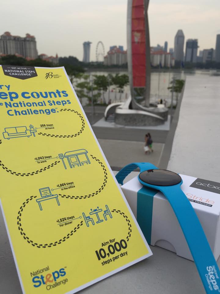 [Photo courtesy of Engr. Joy Garcia]
Such programs are exemplary and are aimed at boosting citizen’s health and welfare. Of course, Singapore can do this and many will respond even without rewards because Singapore has excellent transport infrastructure including an extensive public transport system and suitably designed pedestrian facilities.
Can cities in the Philippines come up with a similar challenge? Are there cities with good enough pedestrian facilities that can lead the way and become good practice examples in promoting walking; not just for the reason of commuting but also as a means to achieve better health among its citizens? Authorities can even include infographics on promotions showing the number of calories you can burn for typical walking trips as well as the health benefits one can derive from walking regularly. I think there are many cities that have decent infrastructure and attractive routes to promote walking. Among them are Vigan City, Marikina City, Legazpi City, Iloilo City and Davao City. Hopefully, these cities can take the cue from Singapore in promoting walking and perhaps, too, a national agency like the Department of Health can pitch in to promote this worthwhile cause for healthier lifestyles.
–
Local papers presented at the EASTS 2015 conference – Mapua Institute of Technology
Mapua Institute of Technology (MIT) has a relatively young program under its School of Civil Engineering. This is led by their Dean, Dr Francis Aldrine Uy, who is also active with the Philippine Institute of Civil Engineers (PICE). Mapua has been aggressive the recent years in presenting and publishing papers in transportation engineering and planning. Following are the papers from the MIT:
- Integrated Non-Motorized Transportation System For A Sustainability Oriented Intramuros [Francis Aldrine Uy]
- A Study on the Effectiveness of Eco-Mobility Component: E-Jeepneys in Makati City [Francis Aldrine Uy]
- Comparative Study of the Effects of Fuel Sources (Diesel, Gasoline and Autogas) in Public Transportation in Metro Manila on Price, Emission and Health Issues [Francis Aldrine Uy]
- Determinants of Demands of Pasig River Ferry Service [Francis Aldrine Uy]
- Determination of Cost Impact using Mathematical Model Comprising City Logistics to Quick Service Restaurants in Metro Manila [Francis Aldrine Uy]
- Development of Evacuation Plan by Utilizing Transportation Modeling in the City of Borongan, Eastern Samar [Riches Bacero]
- Operational Performance Analysis of Median U-Turn Intersections as Traffic Control Facility in EDSA [Riches Bacero]
- Community Perception on Trans-operability of Intramuros [Riches Bacero]
- Paradigm Shift Strategy of Inclusive Mobility: The Applicability of Bus Rapid Transit along Commonwealth Avenue [Riches Bacero]
- Evaluation of Strontium Aluminate in Traffic Paint Pavement Marking for Rural and Unilluminated Roads [Riches Bacero]
- Study on the Impact of the Construction Activity of Skyway Stage 3 on Traffic Conditions along Osmeña Highway and San Andres Street [Geoffrey Cueto]
- A Design for Silver Star Integrated Green Bus Terminal [Geoffrey Cueto]
- Proposed Diversion Road to Improve Traffic Movement of Commercially Developed Areas in Bacoor, Cavite [Geoffrey Cueto]
- Establishing the City Logistic Concept in Improving the Freight Distribution in Metro Manila [Geoffrey Cueto]
- An Analysis on the Accessibility Level of Public Transit for Persons with Disability: In care of Light Rail Transit (LRT 1) [Geoffrey Cueto]
- Design and Development of the Puerto Princesa Airport Passenger Terminal [Jocelyn Buluran]
- Design and Development of Passenger Terminal at Batangas Port [Jocelyn Buluran]
- Design and Development of Passenger Terminal Extension of Clark International Airport [Jocelyn Buluran]
- Determinants of “Travel with Dignity” of Passengers of MRT3 [Jocelyn Buluran]
- Integrating Sustainable Non – Motorized Public Transport in the City of Manila, Philippines Through Analytic Hierarchy Process (AHP) [Jocelyn Buluran]
My only comment about certain papers in the list is that many do not seem to be research papers and definitely more on the practice (i.e., design) side than the academic. I can say this based on the presentations made that I was able to attend as well as the papers themselves in the proceedings of the conference that I was able to browse. Still, Mapua has very good potential to come up with good papers from the prolific Dr Uy and his young faculty members led by Engr. Riches Bacero.
The current President of Mapua, Dr Reynaldo Vea, is also the current President of the Transportation Science Society of the Philippines (TSSP). Dr Vea was formerly Dean of UP Diliman’s College of Engineering and Officer-in-charge of UP’s National Center for Transportation Studies (NCTS). His specialty is on maritime transport as he has a degree in naval architecture.
–
Local papers presented at the EASTS 2015 conference – University of the Philippines
There were a lot of technical papers from Philippine universities that were presented in the recently concluded 11th International Conference of the Eastern Asia Society for Transportation Studies (EASTS 2015). In the interest of dissemination, I will be featuring a list of papers produced by leading universities in the Philippines that are doing studies on transportation. Following is a list of papers from University of the Philippines Diliman that were presented at the EASTS 2015 held in Cebu City last Sept. 11-13, 2015:
- Innovative Collection of Road and Traffic Data for Road Safety Audit (Aileen Mappala & Ricardo Sigua)
- Study on Safety of Railway/Highway Grade Crossings in the Philippines (Albie Clarito, Beverly May Ramos & Ricardo Sigua)
- Instantaneous Fuel Consumption Models of Light Duty Vehicles and a Case Study on the Fuel Consumption at Different Traffic Conditions in Metro Manila using Shepard’s Interpolation Method (Ernesto Abaya, Karl Vergel, Ricardo Sigua, Edwin Quiros & Jose Bienvenido Biona)
- Development of Drive Cycles and Measurement of Fuel Economies of Light Duty Vehicles in Metro Manila (Ernesto Abaya, Karl Vergel, Ricardo Sigua & Edwin Quiros)
- Selection of Metro Manila BRT Corridors Using Multi- Criteria Assessment (Ricardo Sigua & Cresencio Montalbo, Jr.)
- An Assessment of Walkability in a Medium-Sized Philippine City (Hilario Sean Palmiano, Sheila Flor Javier & Jose Regin Regidor)
- Traffic Noise Measurement, Perception, and Modelling in a University Campus (Hilario Sean Palmiano, John Carlo Villar & Michelle Monelle Quilatan)
- Assessment of Metro Manila Bus Fare Computation (Sylvia Chavez & Hilario Sean Palmiano)
- Estimating Road Roughness Conditions Using Ubiquitous Smartphones and Geographic Information Systems and its Application to Road Network Planning in the Philippines (Joel Cruz & Jun Castro)
- Fuel Economy and Public Utility Jeepneys Using 2% and 5% Coco-Metyl Ester (CME)-Diesel Blends (Edwin Quiros & Karl Vergel)
- Comparison of Fuel Economy of Fuel and Operating Characteristics of Diesel and Auto-LPG Jeepneys through On-Road and Vehicle Tests (Edwin Quiros, Karl Vergel, Ernesto Abaya, Ervin Santos & Jose Gabriel Mercado)
- Challenges of Urban Transport Development in Metro Manila: A look back at the last 40 years (Maria Sheilah Napalang & Jose Regin Regidor)
- An Assessment of the Public Necessity Concept for Estimating the Requirements for Public Transport Vehicle (Arnel Manresa, Karl Vergel & Jose Regin Regidor)
- State of Pavement Engineering in the Philippines and Implications on the Economic Life of National Roads (Maria Sheilah Napalang, Jose Regin Regidor & Nathaniel Diola)
- Planning Metro Manila’s Mass Transit System (Ricardo Jose, Daniel Mabazza, Jose Regin Regidor, Marco Stefan Lagman & Jonathan Villasper)
- Evaluation of Compliance of Dimensions and Selected Systems and Components of Customized Local Road Vehicles (CLRV) with Vehicle Regulations and Standards (Karl Vergel, Rachel Habana, Nonilo Peña, Loreto Carasi, Albert Mariño & Alorna Abao)
- An O-D Approach of Estimating Energy Demand and CO2 Emission for the Luzon Road Transport using Inter- Regional Passenger and Freight Flow Data (Marloe Sundo & Karl Vergel)
- Dignity of Travel: BRT Development in the Philippines (Cresencio Montalbo Jr & Colin Brader)
- Mending a Metropolis – Understanding Passenger Demand Across Metro Manila To Improve Road Transit (Nicholas Greaves & Cresencio Montalbo Jr)
- Accident Hotspot Mapping in Quezon City: The case of Katipunan Avenue (Jerome Ballarta, Nelson Doroy, Ishtar Padao & Cecil Villanueva)
Not included in the list are papers coming out of International Research Groups (IRG) as well as those where involvement by UP faculty were incidental to projects. Many of these papers will soon be posted on the official site of the International Scientific Committee of EASTS as part of either Proceedings or Journal of EASTS. Some may be nominated for the Asian Transport Journal (ATS), which is also published by EASTS.
Transportation research in UP Diliman is the most developed among schools doing research on these topics in the country. Papers came from a variety of disciplines and academic units including Civil Engineering, Mechanical Engineering, Urban Planning, Geography and History. These mostly were and are undertaken through the National Center for Transportation Studies (NCTS), which is with UP Diliman.
Next up: De La Salle University
–
EASTS 2015 – Cebu City, September 11-13, 2015
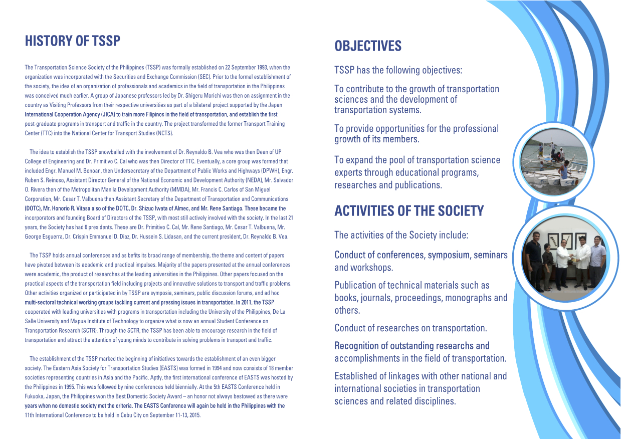
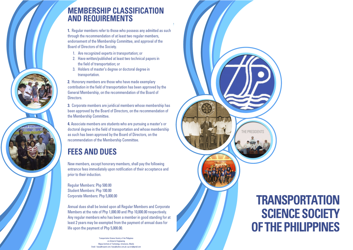
The 11th International Conference of the Eastern Asia Society for Transportation Studies (EASTS 2015) will be held in Cebu City this September 11-13, 2015. For information on the conference and program, check out their website here:
You can also download a brochure about EASTS here:
The conference is hosted by the Transportation Science Society of the Philippines (TSSP), which is the local affiliate of the EASTS. More information on the TSSP are found below:
–
Health and commuting
Why is good public transportation especially transit important? Perhaps transport engineers and planners often get lost in trying to explain this from the perspectives of travel efficiency (e.g., reduced travel times, fuel efficiency, more capacity in terms of people carried, etc.) and environmental concerns (e.g., reduced emissions, reduced noise, etc.). Perhaps, too, there’s a need to articulate the importance of good public transport from the perspective of health. How many people do running, jogging or walking in the mornings, afternoons or evenings just to lose weight? How many go to gyms to workout? Perhaps the key to health lies in just walking everyday and integrating that healthy walk in your daily commutes. Here is a nice article from the Wall Street Journal on the link between the way you commute and a healthy life:
Your Commute Could Help You Lose Weight
Somethings I miss from living in Japan and Singapore are my regular walks to and from the transit station. I recall really good walks between the Transport Laboratory in YNU to the Soetetsu Line Kami Hoshikawa Station. You have to walk up a small mountain almost everyday from the station to the university. I also had good walking buddies back then during my 3 years in Yokohama. Later, I also enjoyed walking or cycling between the Transport Lab at Saitama University and the International House. Often, too, I would walk or cycle to the supermarket, the transit station or just around the neighborhood during free times. In Singapore, our home and the office were also near transit stations so we could take nice walks between them aside from the four flight of stairs to our apartment on the fourth floor. Such healthy commutes can be realized in Philippine cities if proper planning is undertaken and transit projects are implemented not just from the perspective of efficiency but, importantly, from the viewpoint of health. The current state of public transport is not healthy and many, especially those taking the EDSA MRT 3, will say that it is quite stressful to commute in Metro Manila. And stress is definitely not the way to lose weight. Is this true for other Philippine cities as well? Hopefully, we can work out transport solutions that include good public transport to promote healthy lifestyles.
–
Candidates for pedestrianisation?
I friend recently posted on the pedestrianisation of Intramuros and I commented that the walled city that used be equated to Manila should be a prime candidate for initiatives on pedestrianisation. Among the challenges, however, for any project that seeks to encourage walking by reclaiming roads and other spaces for pedestrians in the walled city would be the pedicabs. These are non-motorised three-wheelers that proliferate in Intramuros. There are just too many of these vehicles going around the area. I have mentioned these vehicles in past articles on some streets in the walled city including Calle Real del Palacio, Muralla Street, and Solana Street.
A city that can be used as a ‘good practice’ reference is Vigan City in the province of Ilocos Sur. Many parts of Vigan City are already pedestrian-friendly. In fact, Crisologo Street, which famously represents this city recognised as a UN Heritage Site is off-limits to motorised transport. However, the issue with Vigan is the proliferation of motorized tricycles. There also seems to be an oversupply of these tricycles that many continuously go around the city looking for passengers. The noise and emissions from these roaming tricycles alone contribute to negate part of the attraction of this Heritage City.
Baguio City can be transformed into a walkable city and focus should be on the iconic Session Road where small businesses including restaurants and shops once thrived. I say ‘once’ because the establishments along Session Road have experienced a decline during the past years since a major retail company constructed and started operating a huge mall near one end of Session Road. So much for the small city feel of Baguio and the local shops and restaurants that have suffered from the big business concept brought in by the mall.
In Makati City, the Ayala CBD has been pedestrian-friendly for quite some time now. People-centered facilities include underpasses for crossing major roads like Ayala Avenue and an elevated walkway connecting office buildings all the way to the Greenbelt mall. Unfortunately, these pedestrian-friendly features are limited to the CBD and
In Taguig City, the Bonifacio Global City is a good example where sidewalks are wide enough and there are pedestrian friendly malls like the High Street where people are prioritized over cars. Crossing the streets, however, can be very dangerous at BGC and traffic enforcers need to do more serious enforcing in order to manage speeds and aggressive driving by motorists in BGC. There are already incidences being shared on social media of pedestrians being hit by speeding vehicles or those whose drivers simply don’t give way especially when turning at corners.
In Quezon City, there are few areas that can be regarded as pedestrian-friendly. Among these are the University of the Philippines campus in Diliman, whose core is closed to motorised traffic during Sundays. There are initiatives for making Katipunan Avenue more pedestrian-friendly. However, these initiatives seem to be still far from being implemented on the southbound side of Katipunan where plenty of establishments do not have adequate parking and there are practically no sidewalks for people to walk on. This is the side where there used to be a service road that had to be sacrificed more than a decade ago when the MMDA got engrossed with a flawed traffic scheme.
What cities or streets would be your candidates for pedestrianisation?
All roads lead to Antipolo: rerouting for the Alay Lakad
The Rizal Provincial Government and the Antipolo City Government recently posted traffic rerouting schemes on their Facebook pages. Lalawigan ng Rizal was the first to post schemes that affect traffic in at least 3 major local government jurisdictions – Antipolo, Cainta and Taytay. The schemes affect the two major corridors that basically lead to Antipolo’s National Shrine of Our Lady of Peace and Good Voyage (or Antipolo Cathedral to many) – the Ortigas Avenue corridor and the Marcos Highway-Sumulong Highway corridor. There are many major and minor routes connecting to these corridors and are clearly seen in the maps.
Within Antipolo, there are also re-routing schemes, which the Antipolo City Government posted along with a “clearer” re-posting of the maps from the Rizal FB page. The Antipolo FB page includes information/maps on the rerouting within the city center. These schemes will affect traffic circulation including public transport routes. Critical would be the permanent and temporary terminals and parking areas set-up around the city that should be able to accommodate the thousands of vehicles that are also expected to be used by people who won’t be walking or cycling.
What the maps basically say is that from 4:00 PM today, Maundy Thursday, to 6:00 AM tomorrow, Good Friday, the stretch from Cainta Junction to the Shrine will be closed to traffic. This is to allow the hundreds of thousands expected to make the trek to Antipolo to have the road for themselves. What the maps don’t say is that motorcycles and tricycles would likely be allowed, too. I can understand that motorcycles could easily squeeze into the throngs of people but then allowing tricycles to operate among the walkers and bikers would be risky given their drivers’ behavior. Add to this that they would be making a killing out of charging opportunistic fares.
Technically, the rerouting schemes don’t appear to be as well thought of as can be expected from the LGUs. Baka ito lang nakayanan ng staff o ng consultants nila, and surrender na agad ang Rizal and Antipolo with regards to the coming up with more options for people to travel to the Antipolo Shrine? Not all people can walk or cycle but are willing to an could take public transport for their pilgrimage. The maps themselves are a bit crude and the Province of Rizal and City of Antipolo could have done much better maps given the resources of these LGUs. There are open source tools now available as well as your basic software like PowerPoint or Photoshop (even Word!) that can be used to render good quality images to guide people making the Alay Lakad. This is a regular event and though it happens once a year then perhaps the LGUs could have better plans especially to transport people who cannot make the walk to Antipolo. The objective after all is to convey the masses to and from the shrine safely and efficiently – something a mass transport system can do whether via Marcos/Sumulong or Ortigas corridors.
One reminder to all doing the Alay Lakad: keep your garbage to yourselves if you cannot find a proper waste bin. Do not dispose of your waste along the route and make a dumpsite out of Ortigas Avenue, Marcos Highway, Sumulong Highway or whatever roads you are taking! Kasalanan din po ang irresponsableng pagtatapon ng basura. While you might be forgiven for these “sins” through the Sacrament of Reconciliation (which many will likely take at the Cathedral), nature will have a way of getting back at you for your environmental travesty. –
Swapang drivers
Intersections, especially those with traffic signals, typically have road markings indicating the stop line for vehicles as well as the designated pedestrian right of way for crossing at the intersection. Most intersections also have a typical “yellow box” that is supposed to mark the area that is to be clear of any obstructions (including vehicles and pedestrians) in order for traffic to flow efficiently at the intersection. Despite these and the clear policy on where to stop at intersections based on traffic rules and regulations, many motorists choose to violate these rules and encroach or occupy space that is for pedestrians and cyclists. In the process, these motorists endanger the lives or limbs of people that they might hit as they attempt to get ahead of others. This propensity to “get ahead” or panggugulang in street lingo is widespread and indicative of how the poor discipline among motorists.
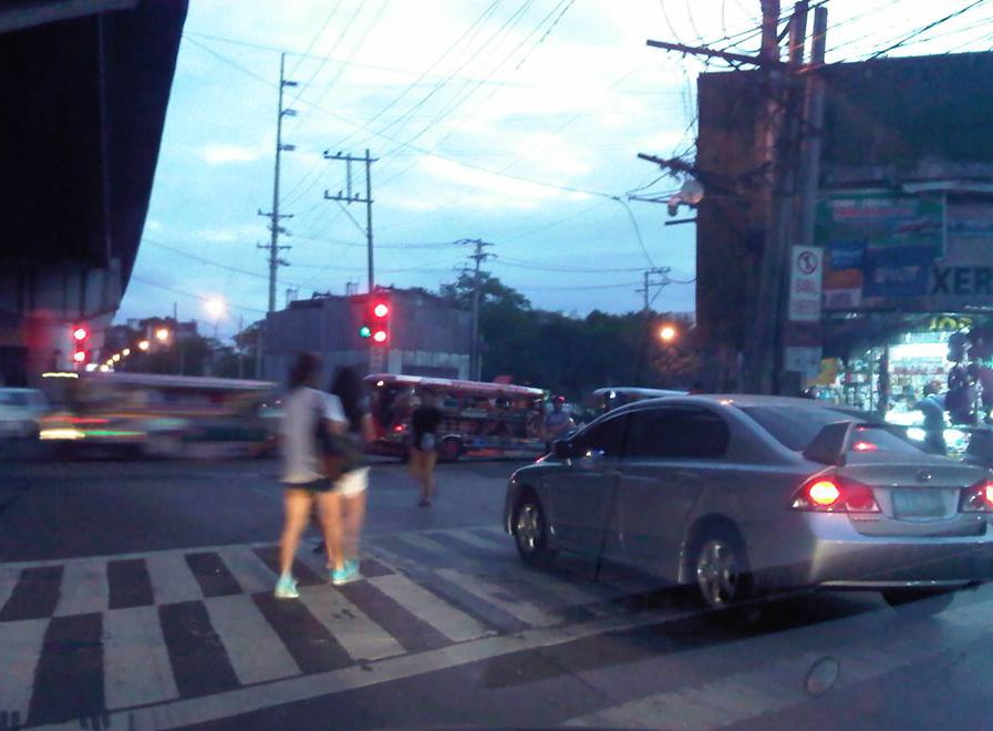 The driver of this car seems to think he could get ahead of everyone else by stopping on top of the pedestrian crossing, which in this case is clearly marked.
There are many cases like this and in some there are traffic enforcers that quickly approach the vehicle to accost the driver. In Makati, erring drivers immediately get a ticket or are fined for such transgressions. The photo taken above was in Quezon City at the intersection of Aurora Boulevard and Katipunan Avenue. There were a lot of enforcers there and very visible but they were only watching traffic and did not mind such cases. I think that if an enforcer was not deputised (i.e., not authorised to give a traffic ticket) then the least he/she could do was to approach the driver, inform him/her of the transgression and then direct the driver to clear the area (basically back up behind the crosswalk).
If and where the enforcer is deputised, then I think they should issue tickets or fine violators to send a clear message that such actions will be penalised immediately and firmly. Word of such actions and their outcomes usually travel fast among motorists especially with social media these days expediting such information dissemination regarding transport and traffic in various areas in the metro. This would be a good way to influence people to improve their behaviour on the roads.
–
On jaywalking, overpasses and informal terminals
I had some errands last December and decided to take public transport instead of taking our car and wasting time parking the vehicle. There was significantly less traffic at that time of the year because schools already on Christmas break and everyone else seemed to be on the slow side of the holiday mode (read: not in shopping mode). I needed to cross the wide road that is Quezon Avenue and there was a sign where I usually crossed that it was now prohibited to cross there. I had to take the overpass to get to the other side and to the jeepney stop to board one to get back to the university.
The overpass at the Quezon Ave.-Araneta Ave. intersection is under-utilized. I base this on the several times I’ve used the overpass. Most people prefer to cross at road level, taking advantage of the traffic signal cycle that allows for gaps in the traffic for pedestrians to cross safely. Of course, there are those who cross any time and seem to tempt fate by their behaviour. They seem to tempt also the MMDA traffic enforcers assigned in the area but from what I have observed, enforcement of the “no jaywalking” policy is usually lax or non-existent. People regularly cross at ground level in plain view of traffic enforcers.
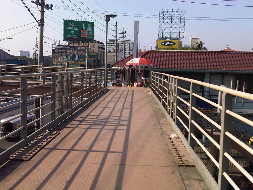 A vendor set-up at the corner of the pedestrian overpass at the Quezon Ave.-Araneta Ave. intersection. Obviously, there are few pedestrians using this overpass as most prefer to cross at ground level.
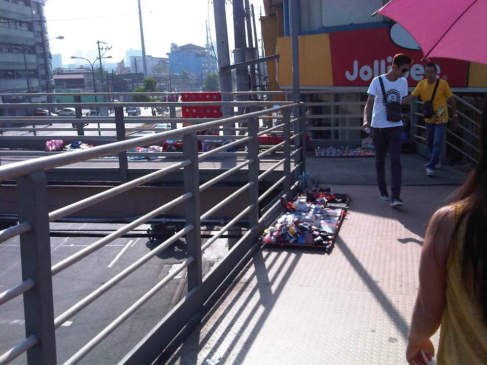 More vendors on the overpass – fortunately, there were few pedestrians using the overpass at the time. Its not the same for other overpasses that are crowded due in part to vendors occupying much of the facility.
 The stairs for many overpasses around Metro Manila are a bit on the steep side. That’s generally not okay with senior citizens, children or persons with disabilities.
There is an informal, on-street jeepney terminal right at the foot of the overpass. If you are in a hurry, its best to try to board a jeepney on the second lane as they are more likely to proceed when the approach is given a green light. From my experience, it takes about 2-3 cycles before the “queued” jeepneys finally cross the intersection. It takes that time to at least have several passengers for the jeepneys before it proceeds to cross the intersection. Most passengers here are transferring from jeepneys plying routes along Araneta Ave. There shouldn’t be an informal terminal here and jeepneys occupy 1-2 lanes of the road at a critical point – the intersection approach. This means intersection capacity is significantly affected and many vehicles could not proceed as they are blocked by the jeepneys. Special mention is made of vehicles wanting to make a right turn but have to go through this “gauntlet” of public utility vehicles. Again, there are MMDA enforcers in the area but it seems the jeepneys and the barkers hold sway and likely with the blessing of enforcers. Such situations are commonplace in Metro Manila and many other cities, and contribute to traffic congestion and other problems commuters regularly encounter.
–

