
Home » Posts tagged 'bikeways' (Page 2)
Tag Archives: bikeways
On riders’ perception of safety
The Federal Highway Administration (FHWA) of the US Department of Transportation released some infographics recently to highlight road safety. One very timely and relevant graphic image asks about which facilities make bicycle riders feel safer:

There were some initial reactions when I shared this on social media with one immediately criticizing share-use paths and citing the one along Marcos Highway (stretch under Pasig, Marikina, Cainta and Antipolo) as an example. I quickly explained that the graphic assumes good designs instead of the flawed one along Marcos Highway. In fact, the shared use path is also quite popular in Europe and particularly in the Netherlands where they have many examples of these paths stretching for kilometers that are exclusive to active transport (pedestrians and cyclists). The good designs need to be shared and circulated so people will know about what they look like and learn about their features. These can be adopted and adapted to local situations.
Did you notice the images of cyclists/riders at the top of the graphic? These are important, too, because they provide context in terms of the type of riders who are the targets for infrastructure and campaigns that support and promote cycling across different types of people. Cycling shouldn’t just be for the most fit or the weekend warriors but rather for everyone who could take it up and not just for recreation but for everyday, utilitarian use (e.g., commuting, shopping, etc.).
What to look forward to Philippine transportation in 2021
I usually wrote a year-ender for transport but somehow never got to it. I’ve spent much of the break working on projects that have been extended due to the pandemic’s impacts on their implementation. Two of these projects are being implemented in Zamboanga City where we are lucky to have hard-working counterparts and a very cooperative city government. I think given what have transpired in 2020, there’s much to expect in 2021. I also want to be hopeful and optimistic about the outlook for this year. So positive thoughts for now. Here are things to look forward to in 2021:
- More bike lanes around the country – these include the bike lanes to be constructed using the billions of pesos allocated for Metro Manila, Metro Cebu and Metro Davao. Is there a plan? None yet unless you count the sketch mapping exercise people have been doing. Sure, the DPWH came up with guidelines for bike lanes designs but these are a work in progress at best if compared to the existing guidelines from countries that have built and maintained bike facilities for a very long time now (e.g., Netherlands, Australia, even Singapore).
- Construction of a Bus Rapid Transit (BRT) in Cebu – this is a much delayed project (more than a decade in the making already) that needs to be implemented already. This year might just be the year? We certainly hope so. That EDSA carousel is still far from being the BRT the Philippines need to be a model system for its cities. I still think Cebu can be a better model for other cities than Metro Manila. And so a BRT success there has a better chance of being replicated in other cities that need a mass transit system now.
- More rationalized public transport routes in major cities – by ‘rationalized’ I am not limiting this to the government’s original rationalization program but also to the other reforms that are being introduced this year including service contracting. Whether the latter will work wonders, we’ll get a better idea of it this year. Will services be better? Will drivers improve the way they drive? Will this be cost-effective in the long run? These are just some of the questions that need to be answered, with some of those answers hopefully coming this year.
- Full scale construction of the Metro Manila subway – would you believe that there’s actually little work done for this project aside from the preparatory and PR work that have been the focus the past few years. It seemed like they’ve been doing realignments and groundbreakings every year. Meanwhile, they haven’t even started tunneling yet. To be honest, I don’t think there will be an operational subway by 2022. I’ve seen subways being built in Tokyo, Singapore and Vietnam, and you can’t do even a demo project in 1.5 years time.
- More air travel – as the vaccines are delivered and administered, there should be a feeling of more safety and confidence for people to travel again. Much inter-island trips are actually done via air travel. Airlines have lost a lot in the last year and are certainly going to come up with nice deals (I already saw a lot of promos from various airlines that I usually book for my flights – PAL, Cebu Pac, JAL and SIA.) Hotels and resorts, too, are welcoming tourists with great deals. So perhaps it will be a rebound year for tourism and…air travel.
- More rail transport in general – hopefully this year will be the year when the Line 2 extension becomes operational. Meanwhile, other projects like the PNR and Line 3 rehabs, the Line 1 extension, and Manila-Clark railway line construction continues. Perhaps this year will also see the construction of Mindanao Railways.
What do you think are things to look forward to in Philippine transportation in 2021?
–
On cycling fatalities and the way forward
I’ve read a few articles and social media posts about how its become more dangerous or risky for cyclists during the pandemic. The statistics and observations show that there is an increase in the number of cyclists. I am not even considering here the recreational ones (and I have observed that there are a lot more of them). I focus rather on those who use bicycles to commute between their homes and workplaces; or those who cycle to market or do their groceries. The danger lies mainly from motorists who have little or no regard for cyclists and pedestrians; choosing to hog the roads for themselves. And there seem to be more of these motorists these days, too, as people owning cars have opted to use these instead of taking public transportation.
Here’s a recent article about safety in the US. Those stats and assessments can be replicated here given the availability of data on kilometers traveled and crashes that are usually employed for risk assessments.
Marquis, E. (December 22, 2020) “Cars have killed almost 700 cyclists in 2020,” Jalopnik.com, https://jalopnik.com/cars-have-killed-almost-700-bicyclists-in-2020-1845934793
The only solution for our case really is to put up protected bike lanes. Local standards or guidelines need to evolve and the people behind these should be of progressive thinking rather than relying on “what has been done” or “what they have been doing”. That attitude will only give us poorly planned and designed infrastructure for cycling and walking. The coming year offers some opportunities for active transportation as the DOTr and the DPWH (plus the MMDA in the case of Metro Manila, and perhaps the LGUs where applicable) are supposed to implement major projects intending to produce the bike lanes and walkways for Metro Manila, Metro Cebu and Davao. The budget is in the billions of pesos so much is expected about these projects. Will they become models for other Philippine cities and municipalities to follow? Or will these be like going through the motions just to appease those calling for active transport facilities?
–
What if our government officials used bicycles for their commutes?
Here’s another quick share of an article about cycling:
Reid, C. (2019) ‘Cherish The Bicycle’ Says Dutch Government — Here’s That Love In Map Form, Forbes, https://www.forbes.com/sites/carltonreid/2019/01/08/cherish-the-bicycle-says-dutch-government-and-heres-that-love-in-map-form/#2951914e2726 [Last accessed: 9/29/2020]
The Dutch have perhaps the densest bikeway network in the world as shown in the article and the link below showing bike lane maps. They also have a government that is pro-bicycle. You wonder what transportation and infrastructure would look like if our government officials biked to work or used public transport on a regular basis. Perhaps these will affect how they make policies and decisions pertaining not just to transport but on housing and health as well? It would be nice to see a counterfactual discussion or paper on this and other scenarios that could help us improve transport and quality of life. This is a big “what if” that many people are actually clamoring for so government can be grounded in the way they make plans and decisions.
Here is the link to Open Cycle Map, which is affiliated with Open Street Map:
–
Painted lines are not enough for bike lanes
From the experiences of many biking or trying to bike in the Philippines, painted lines are not enough for bike lanes. Only recently, cyclists using bike lanes that did not have any physical barriers to deter motorists from encroaching have been involved in crashes, with at least a couple being reported as fatal for the cyclists. Here is an article on what cyclists need in order to ensure or at least improve the safety of their commutes.
UTC (2020) “White lines? Cyclists need more,” ITS International, https://www.itsinternational.com/its8/feature/white-lines-cyclists-need-more [Last accessed: 8/6/2020]
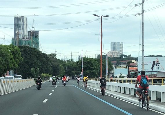 Commuters on bicycles along the Marcos Highway bridge bike lane
Are there differences regarding cycling in different countries? From a somewhat cultural-behavioral perspective, perhaps there are studies (though I am not aware of them yet) about how peoples from different countries or cities behave with respect to cyclists whether or not there are bike lanes designated for the latter’s use. I recall my experiences cycling in Japan and drivers are generally respectful of cyclists on the roads. Pedestrians, too, are very tolerant of cyclists on the sidewalks or designated areas for walking. Of course, the cyclist would have to do their share of respecting others’ spaces, too, and should behave and position themselves accordingly while traveling.
–
On the benefits of shared roads during the pandemic
There is evidence, and they are increasing, for the benefits of shared roads. Here is another quick share of an article supporting that:
Brown, M (2020) “Shared-use roads improve physical distancing, research shows,” Medical Xpress, https://medicalxpress.com/news/2020-07-shared-use-roads-physical-distancing.html%5BLast accessed: 7/30/2020]
With the situation in the Philippines and particularly in Metro Manila appearing to be worsening rather than improving, national and local governments should take heed of the evidence for shared-use roads and the importance of active transport to ensure people’s mobility will not be hampered. This is particularly important for our frontliners and other essential workers if we are to survive this pandemic.
–
On designing street for bicycles
There have been a lot of discussion both online and offline about coming up with bike lanes for Metro Manila. Already, there are examples of pop-up bike lanes in some cities while others have had bike lanes and bikeways constructed years ago (e.g., Marikina and Iloilo). While agencies like the DPWH and MMDA have formed technical working groups (TWG) for bike facilities, the perception is that these are moving too slowly (dragging?) and have not produced any gains in so far as design recommendations or guidelines are concerned. Just how important are such guidelines and perhaps at the beginning, context setting, to come up with suitable designs incorporating cycling (and walking) rather than the usual car-centric set-ups? Here’s another article I am sharing that argues for these street designs:
Jaffe, E. (2020) “The most important bike technology is…street design”, medium.com, https://medium.com/sidewalk-talk/the-most-important-bike-technology-is-street-design-401c94065b5c [Last accessed: 7/26/2020]
People biking to work along the Marcos Highway bridge’s painted bike lane
–
Reference on Bicycle Facility Preferences and Increasing Bicycle Trips
There are many references that are free for downloading. These include the latest publications from the National Academies Press that includes outputs from the National Academies of Sciences, Engineering and Medicine. I am sharing here and posting also as a reference for me to return to a new publication from the National Cooperative Highway Research Program:
NCHRP Research Report 941: Bicyclist Facility Preferences and Effects on Increasing Bicycle Trips by Watkins, Clark, Mokhtarian, Circella, Handy and Kendall.
The research was supported by the American Association of State Highway and Transportation Officials (AASHTO) in cooperation with the Federal Highway Administration (FHWA).
–
Highway 2000, Taytay, Rizal
Prior to taking the photos I posted on Barkadahan Bridge, I was able to take a few photos of Highway 2000.
 Section right after the Taytay Public Market – it is basically a 4-lane road but there are no lane markings for either direction. There is only the double line indicating which sides are for opposing flows of traffic.
 Informal shops along the highway
 There are many garments and textile factories and depots/warehouses along Highway 2000 and from their names appear to be Chinese-Filipino or Chinese-owned businesses.
 There are also several gas stations along the highway including this Shell station that used to have cheaper fuel prices than others like it in Taytay and Antipolo.
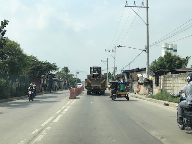
 Bikers along the highway – new pavement markings should include those for bike lanes on either side of the highway. Ideally, bike lanes or bikeways should be protected and consistent with the design along C-6.
 There seems to still be a lot of informal settlers along this road as evidenced by shanties on either side of the highway.
 There are many trucks using Highway 2000. Among them are those carrying tractors or heavy equipment like the one shown here hauling a bulldozer.
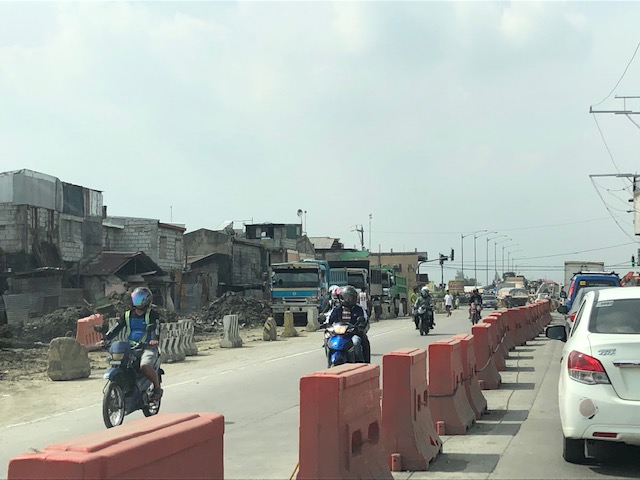
 Orange barriers delineate opposing traffic at the Highway 2000 approach to Barkadahan Bridge. The intersection before the bridge is with the East Bank Road of the Manggahan Floodway.
I posted the following photo earlier. This show the RROW acquired along the eastbound side of Highway 2000.
Highway 2000 already figures as a major link between Rizal and Metro Manila. It is part of an alternate route between Rizal and major CBDs like BGC and Makati via Circumferential Road 6. It is also a route to the south via Bicutan and eventually SLEX. Thus, it is imperative that this corridor and the Barkadahan Bridge be improved in order to carry the potential traffic (both non-motorized and motorized) that it is supposed to. Highway 2000 in particular should already feature protected bike lanes consistent with the design along C-6 in order for it to be transformed into part of a “bicycle highway” that can be the backbone for cycling as a mode for commuting.
–
Reference on bike-focused street transformations
There’s an update to the “Rethinking Streets” guide with one that is focused on street transformation for bicycles. Here is the link to their site where they now have 2 guidebooks:
http://www.rethinkingstreets.com
You will have to click one of the guides to register (if you haven’t done so before) and download them.
–
