
Home » Posts tagged 'buses' (Page 3)
Tag Archives: buses
On the financial viability requirement for public transport operators
I came upon the news that the P2P Bus service between SM City North EDSA and SM Megamall suspended operations The Land Transportation Franchising and Regulatory Board (LTFRB) released a statement to clarify the circumstances surrounding the suspension, which apparently was the initiative of the operator rather than the agency. Apparently, too, some people were quick to attribute (blame seems to be the more appropriate adjective to describe how some netizens reacted) the suspension to LTFRB. Here is the statement posted on their social media page:
Land Transportation Franchising and Regulatory Board – LTFRB
February 23 at 7:52 PM ·LTFRB PRESS STATEMENT ON P2P OPERATIONS OF FROEHLICH TOURS, INC.
23 February 2020The Land Transportation Franchising and Regulatory Board (LTFRB) would like to clarify that it did not order the cessation of the P2P operations of Froehlich Tours, Inc. (FTI) which plied the SM North EDSA-SM Megamall and Trinoma-Park Square routes.
FTI was one of the first to be awarded with P2P routes in 2016. In November 2019, MAN Automotive Concessionaires Corporation (MAN) submitted a letter requesting the Board to look into the financial capability of FTI to maintain its operations, fund expenses that may arise from accidents, and continue to provide public service.
According to MAN, an exclusive truck and bus importer, assembler, and distributor, FTI initially acquired 17 bus units amounting to a total of P185.7 million from them. FTI was only able to pay P39.2 million which resulted in MAN having to repossess 12 bus units. To this day, P19.75 million is still left unpaid by FTI.
While these allegations are still under investigation by the Board, an inspection of the FTI bus units revealed that the company’s Provisional Authority, which allowed them to run and function as a public service provider, has already expired and no renewal was filed.
As of now, an order has been sent out to Froehlich Tours Inc. to submit its 2019 Financial Statement within a period of five (5) days from receipt of a copy. The hearing is reset, upon the agreement of both parties, on 3 March 2020 at the LTFRB Central Office.
Pending the outcome of the hearing, the Board shall adopt measure in the coming weeks to ensure that the riding public will be provided with the needed transport service on the routes affected.
–
There are two major points in the statement. One is on the financial viability of the operator and another is on the provisional authority granted by the LTFRB, which is a regulatory agency. The latter pertains to something more temporary and authoritative than a franchise, which is basically a license to provide transport services. These provisional authorities are often granted by the agency for so-called “missionary routes” as well as for supplementing the supply of vehicles during peak seasons like Christmas, Holy Week and Undas.
Financial viability is a requirement for all public transport operators. It is part of the formula for determining the viable number of units (i.e., vehicles) considering the fare that is to be charged to passengers taking into consideration the operating costs of operators. If this requirement was implemented strictly, a lot of operators would not be operating PUVs in the first place. The LTFRB, however, as well as its mother agency, the DOTr, have been lax about this requirement for so long a time that it is difficult to recall the last case where this was cited as a reason for suspending operations.
–
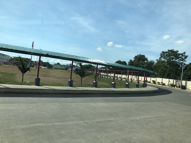
Zamboanga City Integrated Bus Terminal
I open the year by sharing photos of the Zamboanga City Bus Terminal. It is a ‘central’ terminal as most most buses terminate here and cannot proceed to the city center. At the terminal, passengers may transfer between buses, jeepneys and vans.
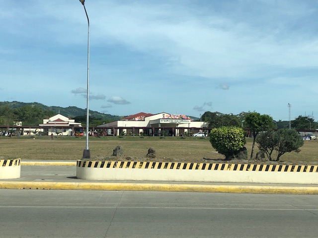 View of the terminal from the national highway. There are driveways leading to and from the terminal from the highway and one can appreciate the expanse between the facility and the main access road.
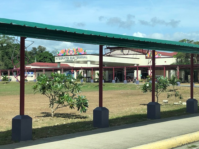 There are covered walks connecting the terminal to the national road.
 Provincial buses and long-distance vans at the terminal
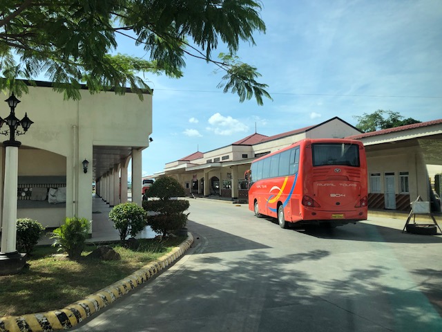 Provincial bus arriving at the terminal
 Jeepneys at the terminal
 Motorcycles parked along a shaded area. The lamp’s vintage design seems to be a good accent to the terminal.
 Close-up showing the spacious parking area shared by cars, jeepneys, motorcycles and even tricycles
 Another look at the covered walkways leading to the national highway. Not all public transport go to the terminal because of the fees and the distance for the diversion from the highway.
 Jeepneys waiting to be filled with passengers prior to departure
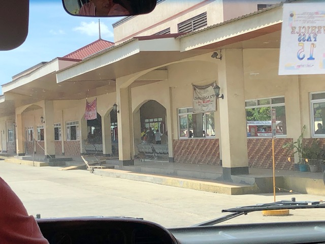
 A look at the front of the terminal shows a wide driveway and the connection of the covered walkway to the main entrance
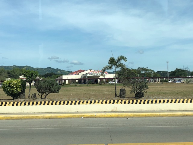 Another look at the integrated terminal from the highway
We will be evaluating the terminal soon as part of a study we are doing for the city. More photos and some assessments about its features soon!
–
New public utility vehicles in Cebu
There have been a lot of new models of vehicles serving as public transport in Metro Manila. It came as no surprise that we found similar vehicles (e.g., Beep or modern jeepneys as some people refer to them) as well as buses in a city that was supposed to have had the first operational Bus Rapid Transit (BRT) line in the country. Sadly, the Cebu BRT has not been constructed and now national government agencies and the local government is mulling a light rail transit system instead. Here are some photos of the Beep vehicles operating in Cebu as well as a couple of bus services.
 Beep mini-bus beside an old jitney – the vehicle sizes are comparable but the Beep capacity is larger. The Beep is also air-conditioned and features a layout similar to buses.
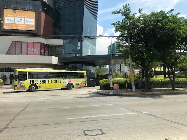 Free shuttle bus service provided by Robinsons Malls
 Beep serving the City Hall – IT Park route
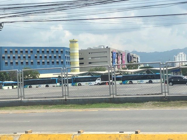 MyBus depot at the SM City Cebu North Reclamation Area – these are currently plying the route connecting SM City Cebu with SM Seaside. The route is actually one that was considered for a pilot Bus Rapid Transit (BRT) line – supposedly the first one in the Philippines – that did not come into reality.
–
Public transport coverage in Metro Manila
I saw several posts circulating on social media about public transport routes in major cities that included stylised maps presented like the transit maps you usually see for cities like Tokyo, Hong Kong and Singapore. These show what the makers identify as the equivalent of stops or stations along the public transport “lines”. These, of course, are a simplification because what appears as a single line may actually be comprised of several. Also, the overlaps seem to be also quite simplified compared to what may be found in reality. This post will not attempt to show how complicated road public transport is for Metro Manila. Instead, I am sharing the maps prepared from a previous study we conducted for the then DOTC (ca. 2012) that show the coverage of three road public transport modes: buses, jeepneys and UV Express.
 PUB coverage for Mega Manila with distinction of EDSA and non-EDSA routes (2012)
 Jeepney route coverage for Mega Manila (2012)
 UV Express route coverage for Mega Manila (2012)
I hope these maps have already been updated or are going to be updated in order for us to have good visual references for public transport planning including the identification of locations for integrated terminals as well as connections with rail transit.
–
More irrational public transport?
I spotted a new vehicle serving a new route between Cogeo in Antipolo and SM Aura in Taguig. I see these vehicles along Marcos Highway from Masinag to Santolan. Friends have spotted the same along C-5 at Eastwood and at Tiendesitas; confirming the route this mash-up between the jeepney and bus is running along. The route overlaps with existing public transport lines along Marcos Highway (mostly jeepneys connecting the eastern cities and towns with Cubao) including the elevated Line 2.
 Jitney running along Marcos Highway in Antipolo (section between Masinag and Cogeo)
The jeepney has a sign stating it is a DOTr project. So is this an experimental run to determine the viability of the route in place of the traditional approach using what was termed as RMC (Route Measured Capacity)? I am not aware of any other ways by which the DOTr or the LTFRB are able to estimate the number and type of public utility vehicles to serve certain routes. There are, however, initiatives to open what they call “missionary routes” but this term used to refer to really new and unserved (referring to formal public transport) corridors or areas rather than those that are already being served by several modes of public transport. The results of this interpretation of “missionary routes” are more overlapping routes that further complicate and undermine efforts for rationalising or simplifying public transport services in the Metro Manila and other cities as well.
I will soon post here three maps showing the public transport route coverage for Metro Manila more than half a decade ago. These show the coverage of buses, jeepneys, and UV express services at the time. I now wonder how these would look like with the new routes overlayed unto the maps.
Airport access by bus at NAIA Terminal 3
The recent trip also afforded me some quick photos of the arrival level driveway of NAIA Terminal 3. Here are some photos including those of airport taxis and buses serving the terminal and its passengers.
 The arrival level (ground level) driveway is not very crowded at 5:30 AM.
 From Bay 11 there are taxis and express (e.g., P2P) buses waiting for their passengers. There are booths on the terminal side for those making inquiries or booking their rides. That’s the Runway Manila pedestrian bridge connecting Terminal 3 to the Resorts World Manila complex at the top part of the photo.
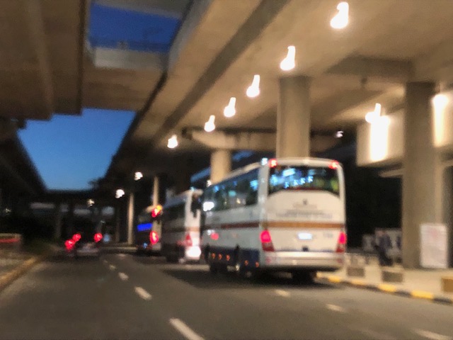 Airport P2P buses include those headed for Clark.
–
On good transit stop designs
We interrupt our regular programming to share this good reference for designing bus stops:
Transit Center (2018) From Sorry to Superb Everything You Need to Know about Great Bus Stops, transitcenter.org, http://transitcenter.org/publications/sorry-to-superb/#introduction [October 2018]

This is a new publication and though the focus is on bus stops, the principles and guides presented are very much adaptable and applicable to other public transport modes as well, particularly the road-based modes we have in the Philippines. The article contains a link for those who want to download the entire report.
–
More high capacity transit for Antipolo!
Two years ago, I wrote about Antipolo being ripe for high capacity public transportation. So far, work is progressing along the Line 2 Extension to Masinag but there’s no word about it being extended further (Cogeo? Marikina?). I have always maintained that the demand in Cogeo, Antipolo is already established and a mass transit line terminating there will certainly be a game changer in terms of commuting. In fact, it may contribute to rapidly developing that area and hasten the development of Antipolo’s government centre, which is a few kilometres further along Marcos Highway.
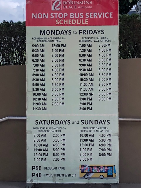 Schedule and fares for the P2P bus service between Robinsons Place Antipolo and Robinsons Galleria in Ortigas Center.
There is now a P2P bus service between Robinsons Place Antipolo and Robinsons Galleria via Ortigas Avenue. And then there is the newest P2P service between SM Masinag and the Makati CBD. The first has very limited capacity at present and have few patrons (regular passengers) based on what I’ve observed and the rough survey my students did for a class project. I still have to see the second one from SM Masinag but I assume it has a higher demand considering a lot of people already commute from that area to Makati. I say so because there’s a nearby UV Express terminal that’s always crowded with people every time I pass by in the morning. This should also translate into demand for the afternoon/evening period. However, I am not so optimistic about the off-peak periods (I hope I’m wrong!) as most P2P services my students have surveyed so far indicate really low occupancies during the off-peak periods.
Is P2P the way to go for Antipolo (and its neighbouring towns like Cainta, Taytay and Marikina)? I think this is still basically a stop-gap measure and a mass transit line as well as complementing conventional buses would still be the most suitable for these rapidly and steadily growing areas. Ortigas Avenue is ripe for a high capacity system that should perhaps be grade separated. The demand was there more than two decades ago. I seriously believe that the Province of Rizal, the City of Antipolo and the high-earning Municipalities of Cainta and Taytay should exert more effort and lobby for a mass transit line serving the Ortigas corridor.
–
Incomplete rationalisation of public transport?
The current initiative to rationalise road public transport services is not as comprehensive as necessary or as some people want us to believe. The drive appears to be mainly on (some say against) jeepneys while little has been done on buses and UV Express vehicles. Most notable among the modes not covered by rationalisation are the tricycles.
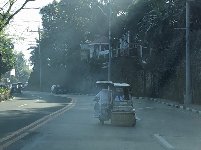 A smoke-belching tricycle along Daang Bakal in Antipolo City
What really should be the role and place of tricycles in the scheme of themes in public transportation? Are they supposed to provide “last mile” services along with walking and pedicabs (non-motorised 3-wheelers)? Or are they supposed to be another mode competing with jeepneys, buses and vans over distances longer than what they are supposed to be covering? It seems that the convenient excuse for not dealing with them is that tricycles are supposed to be under local governments. That should not be the case and I believe national agencies such as the DOTr and LTFRB should assert their authority but (of course) in close cooperation with LGUs to include tricycles in the rationalisation activities. Only then can we have a more complete rationalisation of transport services for the benefit of everyone.
–
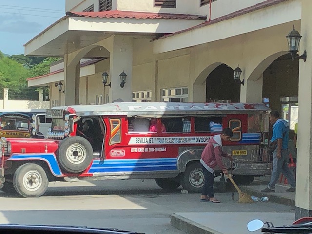
Lazarus franchises?
I was recently asked about my views on Lazarus franchises. At first the term didn’t catch on to me but “Lazarus” is a name that’s associated with coming back from the dead. “Lazarus”, after all, is the Biblical person Brought back to life by Jesus after the latter arrived to find his dear friend had passed away due to illness. It is now being used to refer to a dead public transport franchise that is to be resurrected but under new ownership. I recall I have written about the topic some time ago (many years ago) when I spotted what I thought was a BLTB Co. bus that turned out to be a DLTB Co. Bus. The logo and livery for their buses were the same as are the destinations in Southern Luzon. Then there were the EMBC buses I spotted along my commute that turned out to be operated by RRCG. These obviously are revived franchises and in both cases take advantage of what name recall the brands still have.
 DLTB Co. used to be BLTB Co., which stood for Batangas, Laguna, Tayabas Bus Co. Tayabas is the old name of Quezon Province. This is the current company’s terminal along EDSA in Cubao. The old terminal is also along EDSA near Tramo in Pasay City.
I opined “that brands associated with these franchises can be revived but there are prerequisites. These include an inventory of units currently operating in relation to the demand. The rule is to determine first if existing operators/companies can cover the increasing demand. If not, then the LTFRB may decide to open routes for new players including issuance of new franchises. “New” here probably includes “resurrected” franchises that have name recall among people.” To be clear, there is a process by which franchises are granted by the government and this should be followed in order to be fair with current, active franchise holders.
I wonder if the Antipolo Bus franchise can be revived to serve the old Antipolo – Divisoria route?
–
