
Home » Posts tagged 'cycling' (Page 10)
Tag Archives: cycling
Unprepared and incomplete – realizations from the APEC transport experience
Before I forget about what transpired during the holding of APEC in Manila a week ago, here’s a couple of photos I found over the internet and shared via social media.
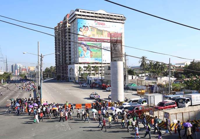 Commuters along Roxas Boulevard walk past a column of the unfinished NAIA Expressway, one of the transport infrastructure projects that has not been finished. [Photo from The Manila Bulletin]
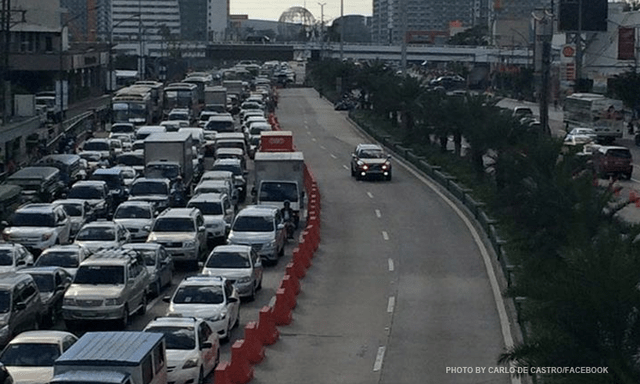 APEC lanes and severe traffic congestion along EDSA – there’s an opportunity here for a prrof of concept test for BRT. [Photo from Facebook]
I saw many memes and read some articles mentioning BRT specifically as one solution to Metro Manila’s transport problems. The second photo above was modified to replace the car travelling along the APEC lanes with a bus.
It is easy to imagine what could have been if the government decided to use the event and the lanes they allocated for APEC vehicles to do a ‘proof of concept’ run of BRT services or at least express bus services (what some DOTC people call high quality bus services). Perhaps what could have been done for part of the 10 billion PHP expended for APEC was to buy a fleet of brand new buses and provided these for free public transport for people who would need to commute during APEC. Services along two corridors would have sufficed – these two would have been EDSA and Roxas Boulevard. [The other option would have been to talk to bus operators and cooperate with them to organize express bus services along EDSA and Roxas Blvd.] Aggressively promoting these free services ahead of APEC would also have meant commuters, including those who usually used their own vehicles, could have opted for these transport services and not affected by the ‘carmageddon’ that ensued over that period. There should have been services to the airport terminals, too, but I will write about this in another article.
The dry run could have yielded essential data for assessing the feasibility of such bus services as an alternate to rail systems that would take much time to build. Incidentally, if the LRT Line 1 Extension to Cavite was built right after the current administration took over, that line could have already served tens of thousands of passengers from the south who regularly commuted to Metro Manila for work and school. The first photo above does not lie about just how many people could have benefited from that rail project. Meanwhile, MRT Line 3 remains dysfunctional and with its reduced capacity could not handle the demand for transport that it should have been able to carry if services had not deteriorated over the years.
–
Caught up in trAPEC
It’s a corny title to this post and perhaps is practically what people would call ‘click bait’. But then it is a very appropriate one considering it describes what happened last Monday and is still happening today and for the rest of the week affected by the Asia Pacific Economic Cooperation (APEC) forum hosted by the Philippines and held in Metro Manila. Yes, Metro Manila. And many people have been asking loudly or in their mind why the capital city when the government was supposed to be promoting and bragging about growth in other cities (inclusive growth anyone?). I would have thought and preferred to have APEC in either Subic or Clark, which have been touted as rapidly growing areas and as international gateways. In fact, Clark is being pitched as the location of a potential new city in the Clark Green City project as well as the aerotropolis currently being developed (slowly) near the airport and the SCTEX Clark South interchange.
Instead, we have the APEC forum and all its attendant activities in Metro Manila. And it seems that the forum has maximized its detrimental impacts on the economy as it practically shut (some people even say shat) down the capital because of severe traffic congestion and a lack of public transport infrastructure and services to carry commuters safely and efficiently between their homes and work places. The Manila Bulletin posted the following photo last Monday:
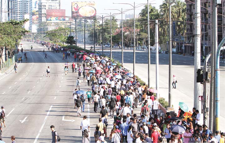 Commuters were forced to walk along Roxas Boulevard just to get to work.
Here are a few more photos courtesy of an old friend from high school:
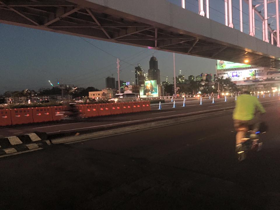 A lone cyclist pedaling along a practically empty section of EDSA (photo credit: Bong Isaac)
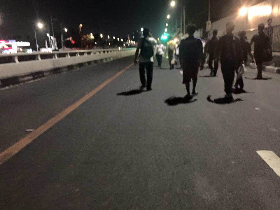 Walkers? – commuters took to walking along EDSA, one of the country’s busiest and most congested thoroughfares. I was amused of the memes about the ‘Walking Deadsa’ referring to people seemingly walking like zombies after a hard day’s work just to get home. (photo credit: Bong Isaac)
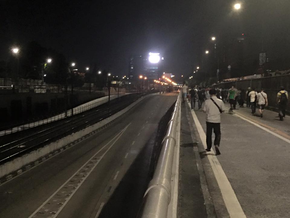 Commuters walking along a vehicle-less EDSA. The MRT 3 line at the left in the photo also seems to be ‘lifeless’ at the time (evening I was told) the photo was taken. (photo credit: Bong Isaac)
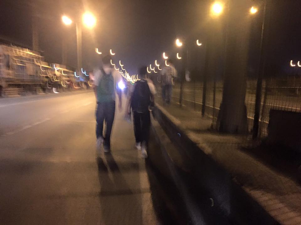 People walking along the service road along the SLEX – most affected of the road closures were people from the southern parts of Metro Manila including those from Laguna and Cavite. (photo credit: Bong Isaac)
I remember being asked once during an interview if it was possible to determine the cost of congestion due to a single event such as a road crash or perhaps a rally. I replied that it is possible given the available tools and expertise in making such assessments. What could be the cost of such a week-long event? Would the holidays for Metro Manila have lessened the economic impacts on traffic of the APEC? Or was it assumed that agreements and the media mileage we got from APEC more than enough to cover economic losses?
Could this disastrous traffic mess have been averted or at least mitigated despite APEC in Manila? Yes, perhaps, if the transport infrastructure particularly the LRT Line 1 Extension to Cavite, the upgrading of the MRT Line 3 and an airport access transit system were completed prior to APEC. These along with other major projects for Metro Manila were promised years ago and yet have not been realized. Add to this the apparent lack of contingencies (BRT-like express buses? bicycles?) that could have eased the pain of hundreds of thousands of commuters affected by APEC traffic schemes. Government has no right to tell people “I told you so” when government efforts for the benefit of its own commuting citizens have been deficient these past years.
–
Misleading information on comparing modes of transport
A major media network sponsored an experiment pitting a bicycle, bus and rail in a race from Trinoma to De La Salle University along Taft Avenue. The bicycle won but under conditions that are favorable to the cyclist even considering Metro Manila’s road conditions that are not bike-friendly (and not pedestrian friendly, too, in many areas).
Would the bicycle have won against a motorcycle where both riders were of similar skills and experiences? Probably not considering the speed of a motorised vehicle even given congested roads.
Would a lot of people consider cycling between, say, Trinoma and DLSU? Most likely not, even if you provide the necessary infrastructure and facilities like bike racks, showers, etc., short of building exclusive bikeways (e.g., elevated).
I have nothing against bicycles and cycling. I have a bicycle myself and I have cycled between my home and the universities when I was studying and a visiting scientist in Japan. However, I have to caution people into thinking and oversimplifying that one mode is better than all others. If we pursue this line of thinking, then perhaps we should include walking in the discussion. I would like to think that there will also be a lot of people who would state that walking (and even running) is better than other modes including cycling. When comparing these two non-motorized modes, however, the advantages of one over the other become obvious – cycling is faster and requires less energy per person traveling using the mode. Such would extend to the motorized modes and comparisons should clearly show the suitability of certain modes of transport over others once distance and capacity are factored into the equation. Thus, we have rail systems as more appropriate over longer distances and are able to carry much more passengers per hour compared to, say, jeepneys. These are even more efficient in terms of energy on a per passenger basis. Further, we have to appreciate that we have to establish a clear hierarchy of transport systems and provide the necessary infrastructure to enable people to have all the options for traveling and especially for commuting.
–
The UP Bike Share project
Students of the University of the Philippines Diliman recently launched an initiative promoting bicycle use in the campus. The UP Bike Share initiative is a welcome initiative that has gotten the support of the community including the UP Diliman administration through the Office of the Vice Chancellor for Community Affairs. Here are some photos of pages of the packet/manual.


You can also check them out at their Facebook page: https://www.facebook.com/pages/UP-Bike-Share/882352095136994?fref=ts
This is an initiative that hopefully will expand especially towards Katipunan and the major schools (Ateneo and Miriam) along that corridor. Perhaps even Teachers’ Village and Sikatuna will be part of a bike share community. It would be nice to see safe bikeways and people on bicycles not just at UP Diliman but a larger area that can benefit from reduced motor vehicle traffic.
–
All roads lead to Antipolo: rerouting for the Alay Lakad
The Rizal Provincial Government and the Antipolo City Government recently posted traffic rerouting schemes on their Facebook pages. Lalawigan ng Rizal was the first to post schemes that affect traffic in at least 3 major local government jurisdictions – Antipolo, Cainta and Taytay. The schemes affect the two major corridors that basically lead to Antipolo’s National Shrine of Our Lady of Peace and Good Voyage (or Antipolo Cathedral to many) – the Ortigas Avenue corridor and the Marcos Highway-Sumulong Highway corridor. There are many major and minor routes connecting to these corridors and are clearly seen in the maps.
Within Antipolo, there are also re-routing schemes, which the Antipolo City Government posted along with a “clearer” re-posting of the maps from the Rizal FB page. The Antipolo FB page includes information/maps on the rerouting within the city center. These schemes will affect traffic circulation including public transport routes. Critical would be the permanent and temporary terminals and parking areas set-up around the city that should be able to accommodate the thousands of vehicles that are also expected to be used by people who won’t be walking or cycling.
What the maps basically say is that from 4:00 PM today, Maundy Thursday, to 6:00 AM tomorrow, Good Friday, the stretch from Cainta Junction to the Shrine will be closed to traffic. This is to allow the hundreds of thousands expected to make the trek to Antipolo to have the road for themselves. What the maps don’t say is that motorcycles and tricycles would likely be allowed, too. I can understand that motorcycles could easily squeeze into the throngs of people but then allowing tricycles to operate among the walkers and bikers would be risky given their drivers’ behavior. Add to this that they would be making a killing out of charging opportunistic fares.
Technically, the rerouting schemes don’t appear to be as well thought of as can be expected from the LGUs. Baka ito lang nakayanan ng staff o ng consultants nila, and surrender na agad ang Rizal and Antipolo with regards to the coming up with more options for people to travel to the Antipolo Shrine? Not all people can walk or cycle but are willing to an could take public transport for their pilgrimage. The maps themselves are a bit crude and the Province of Rizal and City of Antipolo could have done much better maps given the resources of these LGUs. There are open source tools now available as well as your basic software like PowerPoint or Photoshop (even Word!) that can be used to render good quality images to guide people making the Alay Lakad. This is a regular event and though it happens once a year then perhaps the LGUs could have better plans especially to transport people who cannot make the walk to Antipolo. The objective after all is to convey the masses to and from the shrine safely and efficiently – something a mass transport system can do whether via Marcos/Sumulong or Ortigas corridors.
One reminder to all doing the Alay Lakad: keep your garbage to yourselves if you cannot find a proper waste bin. Do not dispose of your waste along the route and make a dumpsite out of Ortigas Avenue, Marcos Highway, Sumulong Highway or whatever roads you are taking! Kasalanan din po ang irresponsableng pagtatapon ng basura. While you might be forgiven for these “sins” through the Sacrament of Reconciliation (which many will likely take at the Cathedral), nature will have a way of getting back at you for your environmental travesty. –
University of the Philippines Diliman Bikeways Flyer (2005)
Searching for material on the proposed bikeways network at the University of the Philippines Diliman campus, I came across a draft of a flyer. The flyer was intended for use in consultations with stakeholders including members of the UP Diliman community (e.g., staff, students, faculty and residents). I recall that there was also a committee established for the purpose of planning and implementing the UP Diliman Bikeways. Unfortunately, the network was not fully realised and took a few years before a major component was implemented but under a different project – the UP Diliman Model Traffic Safety Zone project.
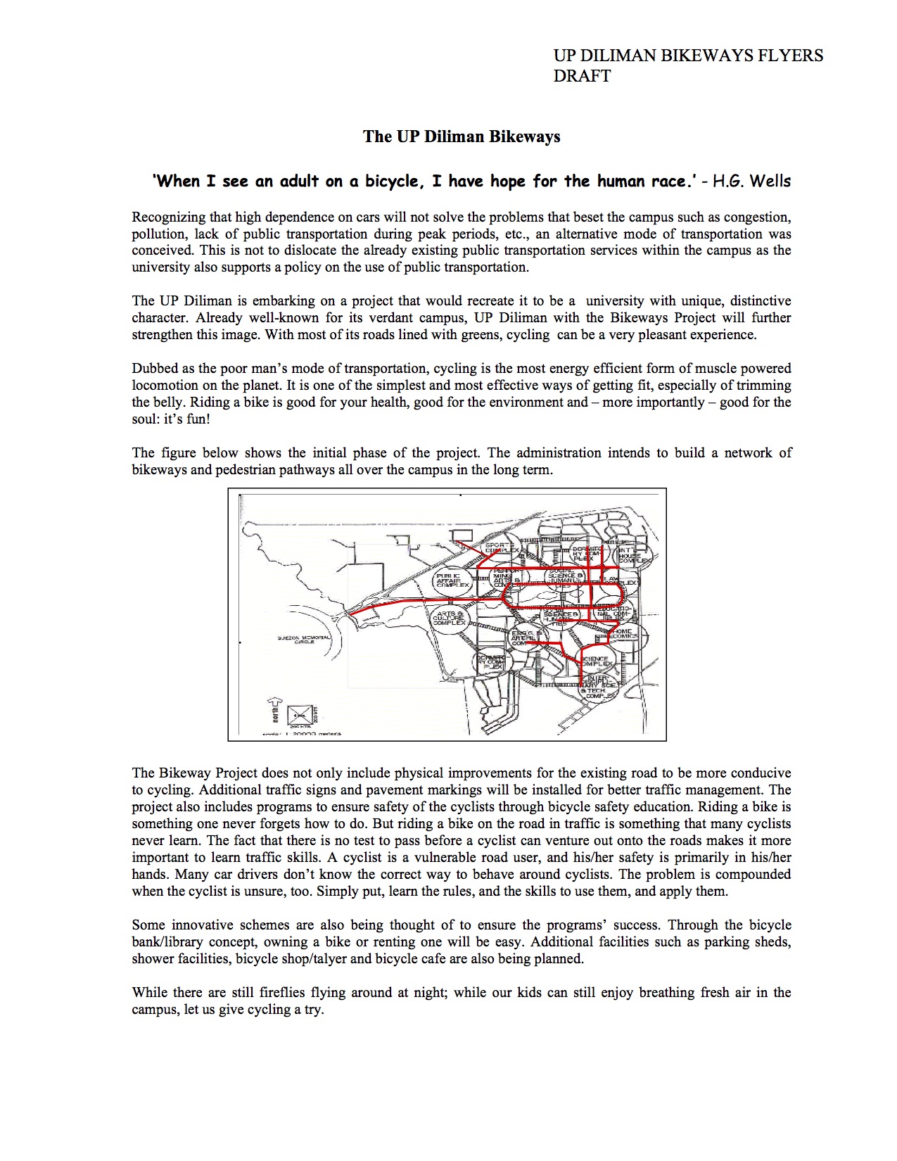
A copy of the flyer in PDF may be found here:
The UP Diliman Bikeways Flyers 2005
At present, UP Diliman is again considering the bikeways network proposal and has initiated some studies towards determining its feasibility including what routes would be most viable. Incidentally, our students in one of the engineering elective courses offered by the Institute of Civil Engineering is currently surveying candidate routes and they should be finished with this task by middle of March. It would be interesting to see which “corridors” can be proposed as the next components of the network to be realised.
–
Bad P.R. for road sharing
A few articles came out of Sun Star Cebu recently regarding an activity over the weekend that was supposed to promote road sharing. I read four articles by different opinion writers. These may be found in the following links:
- A crazy exercise [Bobby Nalzaro, September 28, 2014]
- Sharing narrow roads [Opinion, September 29, 2014]
- Road sharing, road rage [Eddie Barrita, September 30, 2014]
- Green Loop’s faulty premises [Bong Wenceslao, September 30, 2014]
The first three articles seem to be more like reactions of motorists to activities that seek to promote road sharing and cycling in particular. The writers missed the point in so far as road sharing is concerned and are definitely biased towards the status quo in terms of road usage. However, some of their observations need to be qualified as certain roads seem to have been closed with little advise to the general public, many of whom take public transport. The last article is the more grounded one and explains the perspective of non-bikers who are public transport users. This is the calmer opinion among the four and expresses his points in a more objective manner.
I was not there and I haven’t read yet any articles from the organizers or participants to the activity. I would like to give them the benefit of the doubt in so far as their advocacy is concerned. But then one also has to consider the valid points raised by other road users whenever road sharing is equated to cycling rather than a more balanced mix that is focused towards maximising the number of people or amount of goods transported. It is not only a question of space but of efficiency of movement. Bicycles might be efficient in energy but unfortunately it is not the most efficient in terms of the number of people carried between origins and destinations. And we can never decongest our streets in order to make more space for cyclists and pedestrians if we cannot come up with efficient public transport systems that will encourage people to leave their cars or not to buy one in the first place. It can be argued that people are actually opting for motorcycles than bicycles for commuting – another trend that needs to be understood from the perspective of people making these choices for their transport needs.
–
Practicable road sharing in Antipolo
As there are increased calls for more bikeways, we try to look at some good examples of what I’d call “practicable” road sharing. I term it “practicable” because it is something doable or is already being done or practiced. I tried to find a few good examples of practicable road sharing to show that it can be done and usually if all road users respect each others’ right to use the road. This respect can be developed over time and requires some familiarity for each users behaviors. Of course, there will always be abusive or disrespectful people on the road including drivers of different types of vehicles. Reckless or unsafe driving is not limited to public transport or truck drivers. There are also many unruly private vehicle drivers who endanger the lives of others whenever they are on the road. Then there are the motorcyclists, cyclists and pedestrians – all road users and also with bad apples or “pasaway” among them.
Road sharing happens everyday in Antipolo City in the Province of Rizal. Along Ortigas Avenue and Sumulong Highway – the two main routes to and from Antipolo, you will see motor vehicles, bicycles and pedestrians sharing what are mostly 4 lane, undivided sections of the two major roads. Antipolo is a very popular destination for cyclists so even during weekdays you will find a lot of people cycling up and down the mountain roads even during the night time and very early mornings. While many are recreational riders, many, too, are doing this for health. I would bet that a good percentage might be biking to work or school but there are no hard statistics to show this (topic for research?).
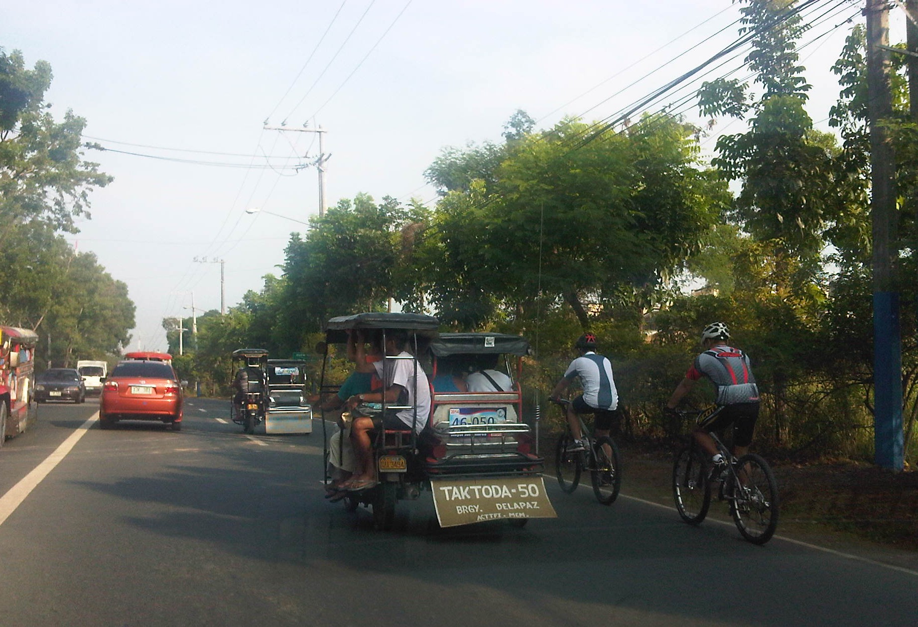 Motorists and cyclists “sharing the road” along Sumulong Highway
Sharing the road shouldn’t be too difficult. However, road users need to have respect for each other’s right to use the road. I have observed many instances where one or more road user types are guilty of “disrespect” and tend to hog the road as if making a statement that “i am king of the road” rather than “i have the right to use the road.” Here are among my pet peeves:
1. Slow moving trucks or jeepneys hogging two lanes and not giving way to other vehicles to pass them.
2. Jeepneys and private vehicles racing up or down the mountain roads and overtaking even in perilous sections (i.e., those already identified as prone to crashes).
3. Tricycles taking up the middle lanes and maneuvering anywhere.
4. Cyclists taking up the middle lanes or sometimes the entire two lanes of any direction preventing other road users to pass them.
5. People crossing anywhere along the road especially at blind sections (curves) where sight distance is limited.
There are practically no pedestrian sidewalks along most of Ortigas Extension and Sumulong Highway so pedestrians would have use the carriageway. As there are a significant number of people walking (e.g., students, workers, and even joggers or walkers), motorists and cyclists need to be careful not to hit these people. The same people, however, need to be aware of these vehicles and should exercise caution, always being alert as they use the road properly. Ultimately though, I would like to see walkways built along Ortigas and Sumulong especially since there is already an increasing demand for walking especially during the summer months when Antipolo holds its fiesta and a lot of people go on pilgrimages on foot to the Shrine of Our Lady of Peace and Good Voyage.
There is practicable road sharing in Antipolo because most road users are already familiar with each others’ behavior and accept each others’ presence and rights on the road. These road users are likely residents of Antipolo or nearby towns or regular visitors to the city. They are “nagbibigayan sa daan.” The “pasaway” people are likely the newer ones who seem to think that the way they drive or ride (i.e., unsafe) elsewhere is the norm. Of course, that goes without saying that familiarity with the roads and its users also breed risk takers who think they already know the road and have the skill and experience to drive like crazy. Here is where effective enforcement (e.g., timely apprehensions and reminders) and engineering (e.g., traffic signs and pavement markings) comes in to address the gaps in safety in order to reduce if not totally eliminate crash incidence along these roads.
–
Innovations for cycling and walking
I usually browse the net for the wealth of information now readily available on transport facility designs that are pedestrian and/or cycling friendly. In the Philippines, there has been an increased awareness lately for people-oriented systems encouraging cycling and walking. These have extended to calls for more bikeways and walkways to enhance mobility, with several projects being implemented to further the advocacies for non-motorised transport (NMT). Of course, there are already existing examples of both good and bad practices around the country including ideal and undesirable cases in Marikina City, which is the first (and only?) city in the Philippines to have a comprehensive network of bikeways.
Recently, I found this article entitled “Urban Innovations That Could Turn Your City Into a Bicycling Paradise” on one of my favourite websites io9.com. It contains some of the more prominent examples of bicycle and pedestrian-friendly designs that have been implemented elsewhere that we could probably take note of as good practice references when we do plan and design similar facilities in our cities. I’m sure there are many people out there, and not just architects or engineers, who would have good ideas for people-friendly infrastructure design. We need to encourage them to come out and propose these ideas that can be adapted into sound design according to architectural and engineering principles (i.e., the designs would still have to follow standards or guidelines, e.g., seismic, wind, etc. in order for these to be safe for use and last long.
Government agencies especially the DPWH and local government units should be open to new ideas or innovative designs to help transform our transport system to become more people-oriented than vehicle-oriented. There should be initiatives from within these agencies to come up with innovative designs while keeping the details up to standards or following established guidelines. So far, there have been no notable push for updating road designs, for example, despite road safety assessment findings and recommendations that should resonate more within agencies and LGUs if they are not comfortable dealing with NGOs or civil society groups advocating for people-friendly infrastructure.
I believe government engineers are competent and have the talent to come up with innovative designs and guidelines but there is a lack of incentive for them to do so and to think out of the box. The bottom-line is still to create an enabling environment for such design ideas to come out and be implemented. Perhaps the academe could lend a hand here with their strong linkages with government planners, architects and engineers. The schools could provide the environment for encouraging new thinking in as far as transport infra is concerned and the leading universities would have the resources that can be harnessed towards innovative designs.
–
“Sharing the road” – bandwagons and fads? Let’s hope not!
There seems to be a lot of talk about “sharing the road” and the initiatives to have more bikeways. I hope I am proven wrong but it seems to me as if these current programs and projects are more of a fad. A lot of people (and local governments) join the bandwagon with little understanding of what needs to be done. It’s usually because of the good PR they get out of these that they agree to coming up with the token carless street or the haphazardly implemented bicycle lanes. More than PR, some cities are aware of the opportunities that come with such initiatives as international agencies and groups are willing to spend money to support such programs and projects. The question really is on sustainability and doing the right thing not only on initiating things or coming up with programs but on the substance itself. And by substance I mean that programs should also go into the details of designs. Too often, the “pwede na yan” approach is taken and this just won’t do.
 The MMDA painted the sidewalks in White Plains and designated them as bikeways, in a way alienating pedestrians.
A vision for what people want to have is there but it is ultimately how the achieve the vision that needs a lot of work. For example, bills are being filed in congress to force the creation of bicycle lanes along major highways. (And mind you there are a lot of similar bills filed in congress that upon closer inspection actually have little substance.) The premise here seems to be that if you build them then people will start cycling. That was not the experience in Marikina, which boasts of the country’s only bikeways network that includes many off-street sections. These bikeways were built at a time when the perception and analysis pointed to a critical mass of cyclists in that city that was thought to be surely the tipping point in terms of non-motorised transport. Nowadays, the same bikeways are used by motorcycles and tricycles and most cyclists we see are not commuters (e.g., cycling between home and work/school) but recreational cyclists. It would take Marikina some effort to promote commuting by bicycles and much effort in enforcement to correct the misuse of the bikeways. The “new” bikeways in Quezon City appear to be poorly conceptualised as the MMDA decided to paint the sidewalks along EDSA northbound without addressing the obstacles like electric posts. Still, it is an effort to put NMT in the consciousness or awareness of the general public (thanks in part to media’s making these news worthy items).
Cities like Pasig and Taguig like to show-off Ortigas Center and Bonifacio Global City, respectively, as their faces when in fact the cities have not done much in their original cores. The running joke is that the real Taguig is not the areas to the west of C-5 but the old Taguig, which is to the east. This Taguig is the one plagued by narrow streets and the proliferation of tricycles. It was not so long ago that a former mayor imposed e-tricycles on BGC (where they were not suitable) while not doing much to lift a finger in the mayhem of tricycles in old Taguig (e.g., along Gen. Luna). As for Pasig, you just have go along the Pasig River and the Manggahan Floodway to see what it has accomplished so far in those areas.
There are no quick fixes to the transport and traffic problems our cities are facing. In the case of Metro Manila, much is at stake for the long-delayed mass transit projects. And the DOTC’s announcements of projects being formulated or proposed are no longer taken seriously as they have not delivered on any of these despite 4 years of this current administration. For other cities, it is important to learn the hard lessons from the experience of Metro Manila. There is also a need for a drastic change in transport and traffic policies in our cities. Iloilo, for example, has built an expensive bike lane along Ninoy Aquino Avenue (Diversion Road) and has marketed its Esplanade as a haven for pedestrians and cyclists. Yet the city has not acted on the clamour to revisit the overpasses along Gen. Luna (Infante and Jalandoni flyovers). The latest information I got from the city is that there are issues in the design of the bikeway along the Diversion Road as the surface (they used pavers) is not suitable for cycling. It seems, also, that the city and cyclists were not consulted by the DPWH when the bikeway was designed and constructed resulting in many cyclists using the Diversion Road itself for traveling. This last example is a lesson for our local governments and national agencies that they need to cooperate with each other and turfing has no place in transport and traffic if we are really serious about bringing solutions to problems we encounter everyday.
–
