
Home » Posts tagged 'history' (Page 4)
Tag Archives: history
On Antipolo’s railway heritage – Antipolo Station
I open 2017 with a post on history and rails. A reader of one of my previous posts on Antipolo and its railway heritage was very generous to include some photos of what remains of the Antipolo Station of the old (shall I say ancient), defunct railway line that traversed what is now still called Daang Bakal. Those comments and links to photos may be found under the post on old railway lines here.
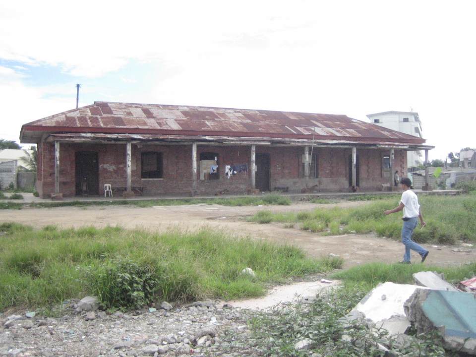
Here is a photo I found in the Kalye ng Antipolo Facebook page:
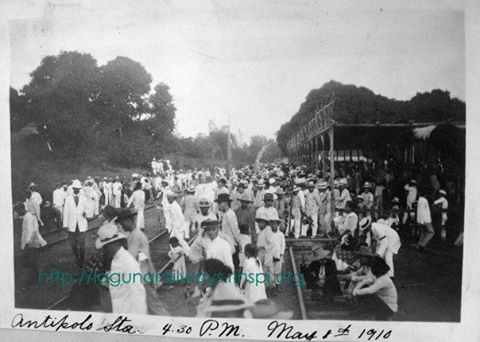
From what I see in the photo, this is a photo of the end station of the railway line that stretched from Manila to Antipolo via Pasig and Cainta through what is now Valley Golf and not via Ortigas Avenue as what some people are claiming. The last two stations were at Antipolo at Hinulugang Taktak, where the remains of the old station are well preserved and there is a historical marker, and at the area that is basically at the intersection of the Circumferential Road and San Jose Street, where the end station would have been closest to the shrine. I am also basing my assessment from the topographic features shown in the photo and the fact that there are three sets of railway tracks shown, indicating that this is also probably a depot for trains. Unfortunately, as mentioned by one of my readers, is in a state where it might soon be demolished due to the road widening project for the circumferential road. I hope the Antipolo government recognizes this important part of its history, its railway heritage, and perhaps help preserve what remains of the Antipolo Station and place a marker there for future generations to appreciate.
–
Antipolo Station of the old railway line
For readers who are interested in the old railway line to Antipolo, please look at the comments section of this old post from November 2012:
What if Manila retained its old railway lines?
Someone (Thank You!) posted about the Antipolo Station, which is the last one along the line and the station closest to Antipolo Church. While the remnants of the old station at Hinulugang Taktak is well preserved and safe (for now) from any future developments, what remains of the old Antipolo Station is now in danger of being demolished. Antipolo and the DPWH are widening the circumferential road located in the area and based on the dimensions of the sections already completed at Siete Media beside the Robinsons mall, the remains of the old station structure may be lost as well.
In my opinion, the city should preserve this part of its history that is also a part of our railway heritage. While such road widening projects may be important, retaining this piece of history is equally relevant as it provides us with a perspective of the past (i.e., how people travelled, what were their destinations of interest, etc.) and learn some lessons about this (e.g., why we should not have wholly abandoned rail for road transport).
–
Transport Planning in the Philippines (WB, 1976)
[Important note: I have noticed that the material on this blog site has been used by certain people to further misinformation including revisionism to credit the Marcos dictatorship and put the blame on subsequent administrations (not that these also had failures of their own). This and other posts on past projects present the facts about the projects and contain minimal opinions, if any on the politics or political economy at the time and afterwards. Do your research and refrain from using the material on this page and others to promote misinformation. I suggest you go to the The Mass Transit System in Metro Manila site for more facts about railway development and history. I do not consent to the use of my articles for the purposes of misinformation and historical revisionism. 10/13/2019]
I know its been a long while since the posts on UTSMMA (1973), MMETROPLAN (1978) and other studies – past studies and plans concerning transport in Metro Manila. It seems apt that I finally was able to finish this piece in time for the Philippines Independence Day. Sinasadya talaga. I left a question hanging about what caused the changes in mindset reflected in MMETROPLAN that practically did away with the proposed mass transit network in UTSMMA. Browsing other materials at the NCTS Library, I came upon a report that I thought would have likely influenced the MMETROPLAN study team as well as government officials at the time. This is the report that I think would be the vital link between UTSMMA and MMETROPLAN – for what happened between these two studies and why the “about face” when feasibility studies were already underway for what could have been the country’s first subway line. The World Bank published a report entitled “Transport Planning in the Philippines” in 1976. The report had recommendations that were not favorable to rail transport whether for long distance or urban applications. Some excerpts are shown in the succeeding photos of pages of the document:
 Cover of the report indicating some disclaimers and restrictions to circulation. I assume that since a copy is found in a public library then it is already declassified. It is definitely a historical document and a valuable one if we are to understand transport in the Philippines and Metro Manila.
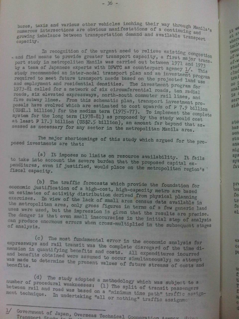 Scan of page 36 showing the WB’s assessment of UTSMMA
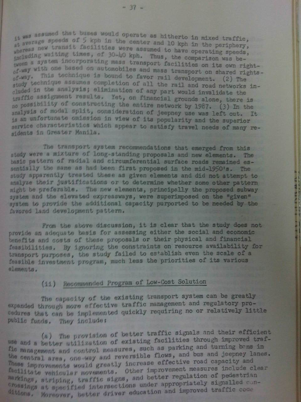 Page 37 states the conclusion of the WB report regarding UTSMMA.
I leave it up to the reader how he/she will interpret this but I think it is also important to contextualize this contents of this report to the situation of the Philippines at the time. In my opinion, too, it is basically one consultant’s word against another. From what I’ve learned, the recommended plan in UTSMMA came from a team led by a very senior and well-respected professor of the University of Tokyo’s Department of Urban Engineering. Looking back now, it seems that their work was visionary and its refuting by this WB report was a critical point in the (non)development of Metro Manila’s transport.
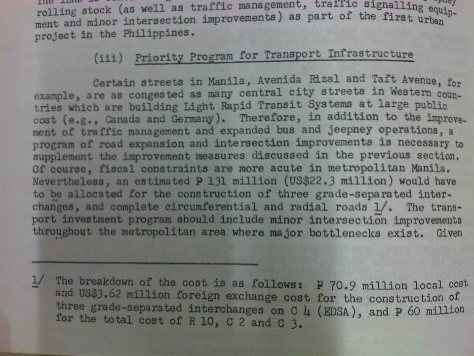 A reference to LRT systems, which to some will seem like a counter-recommendation to UTSMMA
The same report suggested taking a look at LRT instead of the heavy rail recommendations of UTSMMA. This eventually led to subsequent studies seemingly having bias towards LRTs and distancing from much needed resources to improve the plight of the PNR.
 Recommendations for the long term were explicit about the importance of having a sound spatial strategy for Philippine cities.
One could only speculate what went on in the background that were off the record or not documented. Did the WB exert its influence and ‘convince’ the Philippines to shelve ambitious plans for a heavy rail network in favor of what we now know as ill-planned light rail lines? It is this same WB report that recommended for the reorganization of the then DPWTC and DPH into the DOTC and DPWH that we know today. Thus, it is not only transport policy and infrastructure influenced by this report but also institutions dealing with transport. One person’s guess is as good as another in terms of the thinking back then as there are very few people who were directly involved in planning and decision-making then who survive now and are likely willing to divulge anything that will lead us to the truth and some closure regarding what went wrong at this critical time for transport development in the Philippines.
The data and evidence points to something Marcos loyalists would cringe to admit, that the former President ultimately failed in bringing a modern public transport system to this country and its capital. [No, the LRT wasn’t as modern and progressive as they thought it to be back then. We know now that Lee Kwan Yew got it right by investing in heavy rail urban transit at that same time.] We can only speculate that perhaps the WB and those behind the scenes knew Marcos and his ilk would probably steal much of the funds that could have been allocated for the rail rapid transit system and so did their best to come up with the conclusion that it was too expensive and the Philippines couldn’t afford it. I hope my economist friends would correct me but I am leaning towards thinking that “Uutang ka na din lang, umutang ka na para sa imprastraktura na magagamit di lamang ng mga anak mo kundi pati na rin ng mga apo mo at nila.” This seems to be the basic philosophy applied by other nations that have invested much on their transportation infrastructure. Such infrastructure has already paid off many times more and are part of the backbone of strong and resilient economies.
One colleague offered the analogy that the new JICA Dream Plan for Mega Manila is actually an updated version of UTSMMA. I also believe so and it is an updated and much more validated version of what we had back in the 1970s that was at best only partly realized (the recommendations for roads were mostly implemented). However, the price for such infrastructure will not be cheap and it will only become more expensive while we procrastinate in building them. Perhaps this should be an election issue come 2016 and something that we should strongly advocate for from our leaders.
–
Metro Manila Urban Transport Development Plan (1990-2000) Project (UTDP)
I stumbled upon an unfinished draft I have on a study or series of studies conducted back in the 1990’s. These studies were conducted by several agencies over a decade. I think I have been procrastinating on finishing this brief post on a project that has had a major impact on Metro Manila transport and traffic since that time and prior to the completion of the JICA-funded Metro Manila Urban Transportation Integration Study (MMUTIS) in 1999. The project actually overlapped with MMUTIS’ implementation from 1996-1999 and probably influenced MMUTIS in terms of what government agencies provided as inputs to the study.
The Metro Manila Urban Transport Development Plan (UTDP) is an inter-agency collaboration among the DOTC, DPWH, MMA (precursor of the MMDA), NEDA, CHPG (Constabulary Highway Patrol Group of the Philippine National Police) and MTPC. This consists of various studies undertaken from the year 1990 to 2000 aimed to determine what projects can be implemented to improve urban transport in Metro Manila towards the turn of the century. Sounds familiar?
Among the most relevant studies conducted was the comparison of proposals for a mass transit system along EDSA. The two proposals compared were the Philtrak bus system and Street-level LRT. The Philtrak option is quite intriguing because its description is very much like the current bus rapid transit (BRT) systems in many cities around the world. However, there is no reference to bus systems already operating abroad at the time (e.g., Curitiba in Brazil already had an extensive BRT network at the time).
The study concluded that the Philtrak was preferable to the LRT along EDSA. Of course, we now know what got built along EDSA – a light rail system (EDSA MRT) that is now carrying more than twice the number of passengers it was estimated to carry. This is despite the conclusion from collaborating government agencies including the DOTC favoring the bus system with an exclusive ROW. It is also now obvious that neither the LRT nor Philtrak is most suitable as a mass transit system along EDSA. What is most appropriate is a heavy rail system that would be able to carry more passengers along the corridor.
[Reference: UTDP reports, 1999-2000, NCTS Library, UP Diliman]
–
The old railway station at Hinulugang Taktak
The Antipolo City Government recently re-opened the Hinulugang Taktak park to the general public. The National Park and its famous waterfalls have seen better days and is part of Antipolo lore, immortalized in songs and stories about the pilgrimage city. It has been rehabilitated with various initiatives the past few years and with the water again flowing strongly compared to the trickles of dirty water over a decade ago.
Somewhat lost in the promotion of Hinulugang Taktak is a piece of transport history. I am referring to the old railway station located near the gate to the national park. The most convenient and probably most comfortable way to Antipolo and its two main attractions, the Shrine of Our Lady of Peace and Good Voyage and Hinulugang Taktak, many decades ago was by railway. Roads and road transport was not as good as today’s. There were no highways like Ortigas or Sumulong. There were no aircon buses, no jeepneys (yet) and cars and motorcycles were not affordable to most people.
 Old sign? There is no formal historical marker for the former railway station at Hinulugang Taktak. I think the National Historical Commission of the Philippines should recognize this as a local if not national heritage site.
 Trees notwithstanding, this is the view from what used to be the platform of the railway station.
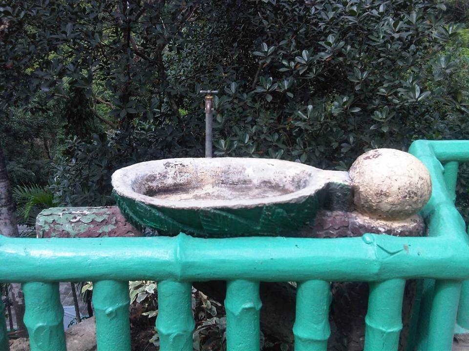 An old drinking fountain that’s probably survived the passing of time and witnessed a lot about the old railway station and Hinulugang Taktak.
 What’s left of the former railway station structure are the platform and columns.
 Taktak Road was the old Daang Bakal or railroad. Much have changed since the glory days of rail with a line that connected Antipolo with Manila.
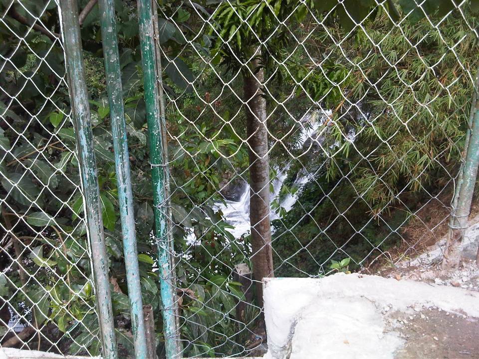 The view from the old entrance to Hinulugang Taktak in what also looked like the old railway station’s ticket office gives people (passengers?) a glimpse of the waterfalls.
 The old entrance to Hinulugang Taktak.
Someone asked me before if I thought it was possible for old railway lines to be revived. I replied honestly that I thought it was possible but immensely difficult. For one, a lot has changed in the lands on and along which the old railways used to be. The old Daang Bakal, for one, now passes through private residential subdivisions and industries and is now comprised of busy roads. While nothing is impossible, to rehabilitate the old railways will be a great challenge in the financial and social sense. It would be nice to see realized but requires so much from so many people, agencies and local governments who need to commit to such a project. And it requires leadership and a talent for convincing people that it is the right thing to do and that it needs to be done.
–
Resurrected bus companies
I posted something recently on an old bus line plying routes between Rizal and Metro Manila. I mentioned there about bus companies somehow being resurrected many years after what I thought were my last sightings of their buses. Of course, it is known that some bus companies have closed shop for one reason or another including what was a government-owned and operated Metro Manila Transit Corporation that used to operate the popular Love Bus. One of the major causes for bus companies folding up is labor problems. Among those that reportedly succumbed to this were Philippine Rabbit, Pantranco and BLTB Co. A few years ago, however, we was surprised to see a familiar bus along the South Luzon Expressway but upon closer look, we found that it wasn’t the old BLTB Co. that was written in the livery but DLTB Co.
BLTB Co. stood for Batangas, Laguna, Tayabas Bus Co. The name alludes to the provinces served by their buses including Tayabas, which eventually became Quezon and Aurora provinces. Their terminal was landmark along EDSA in Pasay City. It is still there along the southbound side and near the junction with Tramo. That will be just beside the left turn overpass from EDSA to Tramo and towards NAIA.
 The livery on this bus is very familiar to many who rode on the old BLTB Co. buses many years ago. Was this deliberate from the owner/operator who obviously wanted to use this to their advantage? People are still familiar with the BLTBCo logo and brand so seeing these buses evoke memories of long distance travel back in the day.
There were few large bus companies in the old days. Among them were Victory Liner, Dangwa, Philippine Rabbit, Pantranco and BLTB Co. Victory, Dangwa and Philippine Rabbit served routes to the north of Manila while Pantranco plied both northern and southern routes. The latter company eventually split into Pantranco and Philtranco, with the northern routes under Pantranco (whose terminal was along Quezon Avenue where Fisher Mall now is located) and the southern routes under Philtranco (terminal is still there along EDSA in Pasay City). Pantranco is no more but Philtranco survives despite the current competition from many other bus companies plying routes south of Metro Manila.
Dangwa’s terminal was in what is still now being referred to as Dangwa in Manila, where you can get all the flowers you’ll need for all occassions. It was, after all, the “bagsakan” of flowers from the north, particularly from Baguio City. Victory’s old terminal is still the one in Pasay though it now has a couple in Cubao. It has expanded its points of destination and is perhaps the largest firm now operating north of Metro Manila.
The Philippine Rabbit Bus Co.’s terminal was at the northbound side of EDSA in the Balintawak area. It has a curious story about it; the stuff of urban legends. The name of the bus company is supposed to be Philippine Rapid Transit (another and real bus company). One time they asked their new buses to be painted, the instructions were misunderstood. “Rapid” sounded like “Rabbit” and that stuck to this day. They also had a labor problem and did not operate for a while until they resolved these issues with their drivers and conductors.
–
The Metro Manila Transportation Planning Study II (JUMSUT II)
Similar to the previous JUMSUT Phase I, the recommendations of Phase II focused on route structure planning and improvement for road public transport to avoid unnecessary competition between LRT, bus and jeepney. Recommendations for route structure planning included the modification of route schemes for the central eastern sector of Metro Manila mainly to alleviate traffic congestion and improve schedules. The study reiterated the recommendations of Phase I.

Following are more photos showing the recommendations of JUMSUT II:

[Reference: JUMSUT II Final Report, NCTS Library, University of the Philippines Diliman]
–
The Metro Manila Transportation Planning Study I (JUMSUT I)
I continue with the series of posts I had started last year on past studies conducted for Metro Manila. It is important to review these studies in order for us to understand how transport in the metropolis came to be how it is now. I believe there are many lessons to be learned and history does not need to repeat itself (although as we can see, it has in as far as transport in Metro Manila is concerned).
The Metro Manila Transportation Planning Study better known as the JICA Update on Manila Study on Urban Transport (JUMSUT) was conducted in two phases, the first one from November 1982 – March 1984 and the second from June 1984 – March 1985, respectively, as a follow-up to MMUTSTRAP. JUMSUT focused on studies to support the implementation of the LRT Line 1 project along Rizal and Taft Avenues.

Recommendations of the first phase are mostly on the rerouting of public transport vehicles along LRT corridor and the traffic management required for the construction and eventual operation of the LRT Line 1. The rerouting is presented as a necessity to avoid unnecessary competition between LRT, bus and jeepney as well as to achieve balanced mode share among LRT, bus and jeepney along the corridor. Following are photos showing a summary of recommendations for JUMSUT I.

[Reference: JUMSUT I Final Report, NCTS Library, University of the Philippines Diliman]
Next: JUMSUT II
–
Some thoughts on transportation heritage in the Philippines
There have been a lot of buzz about heritage conservation and especially the past few weeks about certain buildings in Manila. A lot has been written about this in newspaper columns and blogs, and there have been features on television about heritage conservation focused on buildings, mostly houses, in Negros, Cebu and Panay. Of course, the most prominent heritage project has just been recognized as a wonder of the world in the city of Vigan, Ilocos Sur. I think another area for consideration in heritage discussions is transportation. We do have a lot of historical routes consisting of roads, railways and even trails that could be preserved or enhanced and not just for commercial purposes but more importantly for the current and coming generations to remember and learn about history and heritage.
The availability and accessibility of such tools like GIS, GPS and aerial photography using drones make it possible to do studies and documentation of transport routes such as the old rail line to Antipolo, the PNR’s Main Line North, the Bataan Death March, and even Aguinaldo’s retreat to Palanan, Isabela. There are also pilgrimage routes linked to the most popular shrines in the country like those in Baclaran, Quiapo, Antipolo, Cebu, Penafrancia and Manaoag.
The PNR and Panay Railway lines are good starting topics for transport heritage studies that may lead to some form of conservation. Following are a few photos taken back in 2006 when we surveyed the alignment for what was supposed to be Phase 1 of the Northrail project. The activities were preparatory for transport surveys that would have provided data that were to be used as inputs to estimating passenger demand for the railway line.
 Remaining structures of an old PNR bridge in Bulacan.
 Old PNR station in Bulacan – I can’t recall if this were in Marilao or Bocaue but the red brick building reminded me of similar rebuilt and preserved buildings in Japan such as Tokyo Station and the warehouses at Aka Renga in Yokohama.
 PNR Malolos Station back in 2006 – the building was occupied by informal settlers at the time.
A good reference for those interested in railway heritage and its conservation is a book entitled “The Colonial Iron Horse” by Arturo Corpuz and published by the University of the Philippines Press. There’s a lot of material in that book to get one started about rail history in the Philippines particularly for the island of Luzon and the two main lines of the PNR – the Main Line North and the Main Line South, which I have written about in previous posts. These could be good topics for interdisciplinary studies involving historians, sociologists, anthropologists, architects, engineers and specialist in other disciplines.
–
The Metro Manila Urban Transportation Strategy and Planning Project (MMUTSTRAP, 1983)
I continue on my feature on past studies on transport in Metro Manila. The Metro Manila Urban Transportation Strategy and Planning Project (MMUTSTRAP) was conducted from November 1982 to April 1983, with support from the Australian Development Assistance Bureau – the precursor of AusAID. The study was conceptualized by a Metro Manila Transportation Policy Committee that consisted of the Ministers of the then Ministry of Transportation and Communications (now DOTC) and Ministry of Public Works and Highways (now DPWH), the Vice Governor of what was the Metro Manila Commission (now MMDA), and the Chief of the Philippine Constabulary/Integrated National Police (now PNP). The Philippine Government-funded study examined alternative futures on Metro Manila’s development and used these as the basis for formulating alternative futures for public transport modes. These futures did not mention UTSMMA and its the recommendations for an RTR but presented pessimistic, most likely and optimistic scenarios for PNR, LRT bus and jeepneys.
The study examined recommendations of past studies, most specifically the more recent MMETROPLAN and MMUTIP. MMUTSTRAP seem to contradict MMETROPLAN’s recommendations to encourage the entry of new bus and jeepney operators rather than restricting or controlling these as it (MMUTSTRAP) concluded that “deregulation is not a viable alternative for urban public transportation in Metro Manila.” It further explained that deregulation is justified on the assumption that the main objective in urban public transport is simply to make it a profitable business. To the contrary, the study pointed out that there are other objectives such as adequate service to the public and safety, which should be placed above profitability. This last statement reverberates over the decades to the present when it seems to many that the objective of urban public transport is more on the “profit side” rather than the “adequate and safe aspect” of something that it supposed to be a public service.
The study explored strategies for traffic management and various travel demand management (TDM) measures including area traffic restraint similar to what Singapore had already implemented at the time. A significant output of MMUTSTRAP was a prioritization plan for transport projects and policies for Metro Manila. This included the ranking of projects for implementation in Metro Manila such as:
- Pending road projects
- Potential road projects
- Urgent traffic signals
- Potential pedestrian projects
- Potential transit projects
- Terminal projects
Examples of the transport projects ranked by MMUTSTRAP are shown in Tables A and B for pending road projects, and potential transit projects. An index was developed based on perceived importance of the project and the associated costs.
Table A – Ranking of pending road projects identified in MMUTSTRAP (1983)
| Brief description | Rank | Index |
| Visayas Avenue extension: Elliptical Road to C-6 | 1 | 66.4 |
| Mindanao Avenue Extension: North Avenue to C-6 | 2 | 66.1 |
| C-5 construction: MacArthur Highway to North Expressway | 3 | 64.0 |
| Makati-Mandaluyong Link Road | 4 | 61.4 |
| Loop Road: from Bicutan to Alabang | 5 | 61.2 |
| C-6 construction: North Expressway to M. Marcos Avenue | 6 | 61.1 |
| Widen R-10: C-1 to Dagat-dagatan Spine | 7 | 60.7 |
| C-3 construction: Rizal Avenue to G. Araneta Extension | 8 | 60.5 |
| C-3 improvement: G. Araneta to Aurora Boulevard | 9 | 59.5 |
| Widen South Superhighway | 10 | 58.7 |
| C-4 interchange with Boni Avenue | 11 | 58.6 |
| C-5 construction: R-4 to Pasig Boulevard to Aurora Boulevard | 12 | 58.5 |
| R-4 construction: EDSA to Pasig/Pateros | 13 | 57.9 |
| R-5 construction: Kapasigan to Taytay Diversion | 14 | 57.7 |
| C-5 construction: North Expressway to Aurora Boulevard | 15 | 56.2 |
| C-3 works: Ayala Avenue to Tripa de Gallina | 16 | 55.9 |
| C-3 construction: N. Domingo to Ayala Avenue | 17 | 55.7 |
| Widen Domestic Road: MIA Road to Airport Road | 18 | 55.5 |
| C-4 extension: Taft Avenue to Roxas Boulevard | 19 | 55.3 |
| C-4 interchange with Roosevelt Avenue | 20 | 55.2 |
| C-4 interchange with Ortigas Avenue | 21 | 54.7 |
| C-4 interchanges with Ayala Avenue and Pasay Road | 22 | 54.1 |
| C-4 interchange with Santolan Road | 23 | 53.7 |
| C-4 interchange with Kamias/East Avenue | 24 | 53.2 |
| C-4 interchange with Buendia Avenue | 25 | 52.2 |
| C-5 construction: R-4 to South Superhighway | 26 | 52.1 |
| Widen Parañaque to Sucat Road | 27 | 51.8 |
| Re-align western 1.6 km of Zapote-Alabang Road | 28 | 49.3 |
| R-10 Construction | 29 | 49.1 |
Notes: The codes C and R stand for Circumferential and Radial, respectively, and refer to the main road network of Metro Manila. These roads are more commonly known by other names such as, for example, EDSA (C-4), Aurora Boulevard (R-6) and España Boulevard (R-7).
Table B – Ranking of potential transit projects identified in MMUTSTRAP (1983)
| Brief description | Ranking based on assessment by project team | Ranking based on evaluation from selected MOTC panel | Index |
| Bus replacementa | 1 | 1 | 55.6 |
| PNR Commuter additional coaches and upgrade | 2 | 2 | 50.8 |
| LRT Line #2 – EDSA | 3 | 3 | 44.4 |
| Surface tramway – Radial road along Españab | – | 4 | 43.9 |
| LRT Line #3 – Radial along España | 4 | 5 | 43.0 |
aAssumed that additional bus units will not be needed in the next 5 years with replacements likely after 1987.
bProject proposed by one of the members of the MOTC panel. This was treated as an alternative (on a mutually exclusive basis) to LRT Line #3, rather than an independent project for ranking.
[Reference: MMUTSTRAP, 1983 – NCTS Library]
Earlier studies recommended projects but did not show lists ranking projects in terms of an objective index or criteria. MMUTSTRAP did a good job in coming up with this idea or basis that was transparent and objective in evaluating projects. The criteria, however, is based mainly on perception of those involved in the study and, arguably, such perceptions may vary according to the knowledge and experiences of those involved in the evaluation. This is where the biases lie in as far as project prioritisation was concerned for this project. Perhaps a more participatory approach could have been conducted? Of course, it can be argued that at this time, both capacity and capability of local governments and national agencies were quite limited and so these have to be dependent on consultants (i.e., the study team) for their assessment and recommendations.
–
