
Home » Posts tagged 'rural roads'
Tag Archives: rural roads
Article share: on making roads greener
I came upon this article on ‘greening’ roads:
Goldfarb, G. (December 23, 2023) “This Radical Plan to Make Roads Greener Actually Works,” Wired, https://www.wired.com/story/this-radical-plan-to-make-roads-greener-actually-works/?bxid=5bd6761b3f92a41245dde413&cndid=37243643&esrc=AUTO_OTHER&source=Email_0_EDT_WIR_NEWSLETTER_0_DAILY_ZZ&utm_brand=wired&utm_campaign=aud-dev&utm_content=WIR_Daily_010324&utm_mailing=WIR_Daily_010324&utm_medium=email&utm_source=nl&utm_term=P8 [Last accessed: 1/4/2024]
To quote from the article:
“The very notion that a road can be “green” seems oxymoronic: A vast body of scientific literature demonstrates that roads befoul air and water, fragment ecosystems, introduce non-native species, and obliterate wildlife.”
That was a pretty damning or severe statement about roads considering such infrastructure are necessities in today’s world. Perhaps we should revisit road planning and design to address these issues referred to. Aside from that quote, the article related a number of good examples worth replicating. In fact, I recall that many Philippine roads were envisioned, even designed, to have greenery along them. The tragedy is when the DPWH and LGUs departed or deviated from these plans. The road widening projects of the past years are examples on how national and local agencies have proven the article’s author right about green roads being oxymoronic.
–
Scenic highways? On the irony of “Daang Kalikasan”
There’s a lot of buzz about new roads nearing completion in the provinces of Pangasinan and Zambales. What is touted as scenic highways became an instant hit and attracted a lot of visitors who apparently wasted little time in trashing the area. The recent news now state that the road has been closed due to the garbage and some road crashes attributed to the influx of tourists in the area:
Mountain roads linking Pangasinan, Zambales closed over accidents, trash
There were a lot of posts that appeared on my social media newsfeed about these roads and the scenery around them. While I have seen a lot of roads with splendid or even magnificent sceneries whenever I go on road trips, the first thing that came to my mind was a question whether the landscape was like that before. I suspected that there used to be forests on these mountains and that the trees were irresponsibly cut down (some people will use the word ‘harvested’ as if they grew and cared for the trees) and never replaced. Some friends from Zambales say there used to be trees there and another recalled old dirt roads in the areas used for logging. So it’s ironic that the road is named “Daang Kailkasan” when nature was practically raped by people who ravaged the land many years ago. Indigenous people who we often refer to as “katutubo” also would likely have never consumed more than what they needed. Scenic? Maybe ‘depressing’ is a more suitable term for these roads.
–
Data on local roads – digital maps
Here’s another quick reference to an article describing a current undertaking to map the 45,000+ kilometers Philippine road network:
PH undertaking $5M digital mapping of 45,000-km road network
What’s significant with this development is that soon the country will have excellent maps, including 3D and 360-degree views of most if not all local roads. While there are similar maps via Open Street Maps and Google Maps, the latter are not as comprehensive. These maps will be very useful for a lot of applications including transport planning, urban and regional planning, and disaster mitigation. A lot of people are surely looking forward to the completion of this project as well as when the maps can be accessed and used.
–
The need for basic transport infrastructure
The need for basic transport infrastructure cannot be emphasized more when we see photos or reports on makeshift bridges and very rough roads that many people use for travel between their homes and the places where they work, attend school or to go to markets to sell or purchase items like food. Many people living in rural areas continue to be in poverty because they lack the infrastructure required for them to be productive. Nevermind that most wealth and productivity is in urban areas. Are we encouraging people who don’t have to be in cities to flock to the cities? And who will be left in the farms? To fish? To produce the food that is so vital for everyone? This is actually a delicate system that hangs in the balance if we cannot support rural development as well as we have urban development.
 A hanging bridge in Tarlac is basically the only way for people to travel across this river, which swells during the wet season. The span is suspended from two columns at either ends of the bridge where there are makeshift stairs for people to climb unto and off the bridge.
 Another view, this time from one end of the hanging bridge shows a crude structure made out of steel cable, reinforcing bars and whatever wood they could use as planks and hand rails. It looks flimsy but they make do with it out of need. We learned that in times when the bridge was destroyed by typhoons, they would rebuild it with little help from the government.
The term “buwis buhay” comes to mind every time I look at these photos and others I have taken of rural roads in Tarlac and other parts of the country. People, especially children and those working hard to care for their families, should not have to risk lives or limbs just so they could go to work or school. Farmers and fishermen should be provided efficient access to markets so as to encourage them to continue in their contribution to food production. And perhaps we should think twice about building expensive white elephants for vainglorious attempts at mega structures especially when we still have a lot to accomplish in basic transport infrastructure.
–
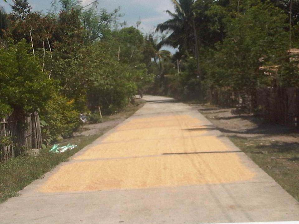
Roads as solar dryers – Part 2
This is a continuation of an earlier post on roads being used as solar dryers. Our trip across Tarlac brought us to more of these facilities being used for agricultural purposes. The following photos are from San Jose and Mayantoc towns, which are obviously predominantly agricultural. The photos show lands devoted to agricultural as far as the eye could see and most are planted with rice.
A friend commented that something should be done to reduce if not eliminate such practices along roads. I replied that this is basically the responsibility of local government units including barangay officials who should be educated about the dangers posed to travellers as well as the deterioration in the quality of the rice as it gets compromised from the waste and grinding they get from vehicles. In terms of practicality and recognising the limitation in funds for solar dryers, roads seem to be the easier and versatile option. Basketball courts and other concreted spaces scattered around the countryside do not make sense where roads would have more use especially to address accessibility issues (e.g., farm to market roads).
Another friend commented on the earlier post that he almost had a collision with another motorcycle rider as the entire road was covered with rice being dried by farmers. I reasoned out that for rural roads with very low traffic, a single lane covered with rice could be tolerable but using the entire road width just is not right. Motorcycle can easily slip or skid along such rice-covered roads resulting in serious injuries if not fatalities. For most cases of what I’ve seen recently, the roads quality as having low traffic and rice is being dried only along one lane so we know at least that people are aware that one lane should at least be free of obstructions.
 1
1
 2
2
 3
3
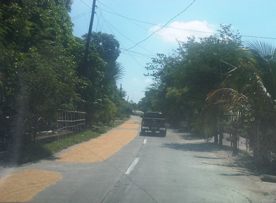
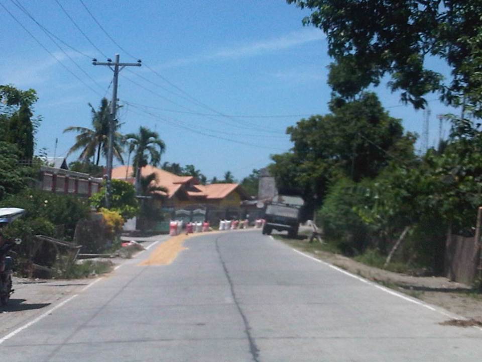
 4 – That’s corn being dried just beside the pick-up truck in the photo.
 5
5
 6
6
 7
7
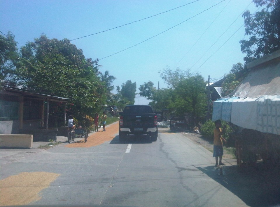
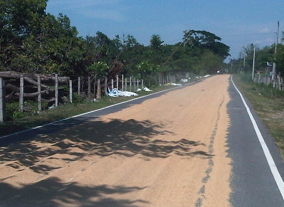
 8 – Bad practice of spreading the grains across the entire road carriageway
 9
9
The last photo is of corn kernels being dried on a basketball court. You can see the cobs piled near the stage, which shelters what looks like sacks of corn. As I mentioned earlier, it is possible to have such basketball courts or social facilities to be used as solar dryers. Even schools grounds can be used for this purpose but only for weekends or during the summer breaks. However, it would be impractical to have basketball courts and plazas scattered all over the countryside just for this purpose especially in places where there aren’t much people in the first place. Roads still offer the more flexible use (i.e., access/FMR and solar dryer) as long as traffic is not significant. Perhaps where traffic is significant (i.e., significantly populated areas) then such “off-road” facilities should be constructed. But again, the responsibility for making sure roads are clear of agricultural products would fall unto the LGUs.
–
Roads as solar dryers – Part 1
We are currently undertaking a project for the Province of Tarlac that looks into the safety along its rural roads (both national and provincial roads) including those providing access to tourism areas in the province. Along many rural roads are agricultural lands producing rice, corn, fruits, vegetables and other products. Often, travellers will encounter roads that serve another purpose other than transport – as solar dryers. Before rice is milled, it needs to be dried first so that it would be easier to remove the husk (i.e., separate the bigas from the ipa – together they are called palay). While it is possible to do this drying on mats (banig) spread over the land/soil this takes time. Meanwhile, portland cement concrete roads offer what seems to be the perfect surface for drying. As such, certain roads have been known to get justification for concreting despite low traffic volumes as they double as solar dryers. There are similar cases for basketball courts or village plazas receiving funding for concreting for the same reasons. Obviously, laying out rice on the roads have implications on the quality of the rice later on as vehicles will inevitably (even inadvertently) pass through the roads. I guess its even worse in cases when the road surface is of asphalt concrete. Following are photos I took along rural roads in Bamban, Capas and San Jose towns of Tarlac.
 1
1
 2
2
 3
3
 4
4
 5
5
 6
6
 7
7
 8
8
 9
9
 10
10
Other items that are usually dried on the roads include tingting (the stems of coconut leaves that are used to make brooms – walis tingting) barbecue and fish ball sticks. I have also seen fish being dried on the road one time during a trip to Northern Luzon. Obviously, among the risks are the rice being grinded by the tires of vehicles (resulting in durog na bigas more suitable for porridge), fuel or oil compromising the rice, and the prospects of animals doing their thing on the road near or on the rice!
More on these solar dryers in the next post!
–
Some good reads on rural roads
A couple of articles came out recently on Rappler that focuses on rural roads:
Farm to market roads: a farmer’s journey, March 5, 2014
The future of rural roads, March 8, 2014
Both are solid articles and places our attention to rural roads and particularly farm to market roads (FMRs). There’s a wealth of information in the articles as well as the links embedded that allow us to see past and present efforts on rural roads. It is good that government with the help of international agencies are investing resources on these roads and we hope that this will be sustained in order to effect what has been touted as inclusive growth.
 Rural road connecting to a national highway in Palawan
Rural roads are an important and integral part of of our transportation system. Often, attention is placed on national roads, which are under the jurisdiction of the DPWH. Local roads, however, are under various entities including the Department of Agriculture and various levels of local government (e.g., provincial, city, municipal). Of course, there are roads that are rural but are national and therefore under the DPWH. But most roads are classified as local and therefore would not be directly under that national agency. In fact, 85% of our roads are considered local and those classified as rural comprise perhaps more than 70% of the total roads in the country (i.e., national roads can be urban or rural, and city roads include those in the rural parts of cities). Rural roads including FMRs are essential as they provide basic access to jobs, education, health services, markets and other services that could help alleviate poverty and promote development in rural areas.
–
Romulo Highway: San Clemente – Lingayen
Romulo Highway originates from Tarlac City and passes through the towns of Sta. Ignacia, Camiling and San Clemente in Tarlac, and then the towns of Mangatarem, Aguilar, Bugallon and in Pangasinan. It ends at Lingayen, Pangasinan, in essence connecting the capitols of two major provinces in Central Luzon (Region 3/Tarlac) and the Ilocos (Region 1/Pangasinan).
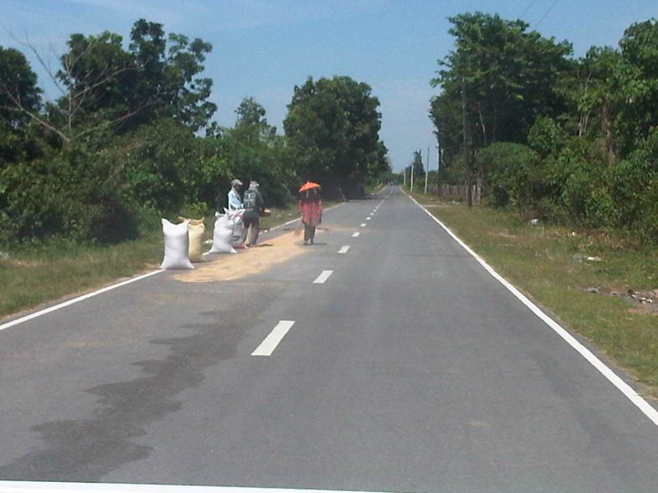
 Solar dryers – a common sight along Philippine highways is palay spread out along the shoulders to dry naturally under the sun
 Good condition – pavements along sections of the Romulo Highway between San Clemente and Lingayen are generally well-maintained
 Approach to intersection – the island is part of the channelization at the junction to physically separate vehicles approaching the junction.
 Channelization – the islands along with directional signs help guide motorists at the junction.
 Approaching a curve – this section can be a little tricky with a climb towards a horizontal curve.
 Sharp curve – the curve is sharp enough to necessitate the installation of chevrons. This is combined with a climb or descent.
 Reverse – it turns out that this section is actually a reverse curve, which increases the complexity of the section for drivers and riders.
 Transition to a bridge – the reverse curve leads travelers to the Bugallon Bridge across the Agno River (direction towards Lingayen). Note the 20-ton limit of the bridge indicating that it is a relatively new bridge applying the DPWH standards for load limits.
 Bugallon Bridge – is typical concrete bridge structure without an arch. Barriers are concrete and should be able to withstand collisions with most type of vehicles.
 Agno River – is part of one of the larger river systems in Luzon Island and the country. The river becomes the Tarlac River when it branches out to Tarlac Province.
 Bugallon Bridge – continuation of the long bridge terminating at an embankment that leads to another bridge towards Lingayen.
 Padilla Bridge – is a steel truss bridge that is older than the Bugallon Bridge not only based on the form (many old bridges along national highways are steel truss bridges) but also on the load limit of 15 tons. The lane widths are also narrower than that of the Bugallon Bridge.
 Padilla Bridge – is longer than the Bugallon Bridge as it crosses a wider branch of the Agno River system.
 San Jose Bridge – viewed towards Lingayen from Bugallon is a relatively short steel truss bridge.
 San Jose Bridge – view towards Bugallon from Lingayen is probably the same age as the Padilla Bridge. This bridge also has a 15-ton load limit.
 Crossroads – vehicles turning to the left will be headed back towards Tarlac through Bugallon and Mangatarem. Going straight will take the traveler to the towns of Labrador, Sual and the general direction of Alaminos and Bolinao. The SUV on the left is headed for Lingayen and Dagupan.
 Provincial boundary – a simple arch marks the boundary between Pangasinan and Tarlac. A little further downstream is another arch formalizing the boundary for the Municipality of San Clemente in Tarlac.
 First town after the border – San Clemente is the first Tarlac town along the Romulo Highway upon crossing from Mangatarem, Pangasinan.
–
Cagayan Valley Roads – Part 2
To continue with Part 1 of my feature on Cagayan Valley Roads, the following photos were taken along the national roads from Nueva Vizcaya to Cagayan (Tuguegarao).
 After Dalton Pass, motorists continue on winding mountain sections, often with little protection against flying off the road
 Community in a valley in the mountains as seen from the national highway
 The hills seem to be silent witnesses to intense logging in the past that has left us with a lot of barren hills and mountains. I could only imagine how these hills could have looked like if there were still trees.
 Entering Bambang, Nueva Vizcaya, I was a little disappointed that there was no grand arch like those marking boundaries in other cities or towns along national highways. Instead, there’s this sponsored sign on a gantry. Ahead, some of the chevron signs have been stolen, leaving only a few installed and empty posts.
 Reverse curve section with concrete barriers to keep cars from going off-road and into the ravine on the right. These barriers, however, will be unable to stop larger vehicles.
 I was both a bit surprised and delighted that tricycles used the shoulder (or is it parked?) and got out of the way of general traffic. I now forget the exact name of the place but this is somewhere in Bambang in Nueva Vizcaya and the tricycles here are not garapal users of the road.
 There are many trucks traveling along the Pan-Philippine Highway as this is a major route for a lot of goods. Isabela province, for example, produces rice that is transported mainly to Central Luzon and Metro Manila.
 This typical 2-lane concrete bridge is relatively new judging from the 20-ton limit indicated in the sign. Older bridges would have 15-ton limits.
 The sign before the bridge allows motorists to assess distances to major towns along the highway: 8 km to Bayombong, Nueva Vizcaya, 13 km to Solano, Nueva Vizcaya, and 70 km to Santiago, Isabela. The two-lane bridge doesn’t have enough space for pedestrian use or breakdowns.
 There are many straight, long sections like this between Bayombong and Bagabag.
 I forget now but this section is also likely to be somewhere between Bagabag, Nueva Vizcaya and Cordon, Isabela. Bagabag is close to the provincial and regional boundary with Banaue Province (Cordillera Autonomous Region) and there are signs pointing travelers to roads going to Baguio City and Lagawe.
 I forget now but this section is also likely to be somewhere between Bagabag, Nueva Vizcaya and Cordon, Isabela.
 Calao Bridge in Santiago City, Isabela is an example of old school bridgework using steel trusses. It is similar to many other bridges including those still standing in the Visayas and Mindanao.
 From Santiago City, we decided to take the alternate route using the Santiago-Tuguegarao Road. Our assessment was that this would be less congested compared to using the Cagayan Valley Road, which passes through more populous towns like Cauayan and Ilagan.
 Arch announcing our arrival at Cabatuan, Isabela province along the Santiago-Tuguegarao Road.
 Typical two-lane bridge in Isabela along the alternate route to the Cagayan Valley road. Our decision to take this road seemed to be a good one as traffic was very light and we could travel without worrying too much about tricycles or pedestrians.
 There were rice fields on both sides of the road. The concrete pavement was satisfactory and allowed us to travel at high speeds. Fortunately, there were few communities and people living along the highway at the time.
 I like seeing rice fields with the plants growing and the greenery indicating its is well-irrigated. This was taken in mid-February so I am pretty sure that since it was months before the wet season, the area had an abundant harvest.
 Sunset in the Cordilleras
 The light from the sunset presents travelers with surreal sights with the rice fields and the mountains often combining for picture-perfect moments. I took this with my Canon Ixy on-board a moving vehicle!
 Another shot of the country side along the Santiago-Tuguegarao Road. This highway will actually pass through Kalinga province and there is a junction after Quezon town where travelers can turn left towards Tabuk, the capital town of Kalinga.
 Crossing the Buntun Bridge after Enrile town brings the traveler to Tuguegarao. The bridge spans the width of the Cagayan River, the longest and largest river in the Philippines, which deserves to be called by its name during the Spanish period – Rio Grande de Cagayan.
 Cagayan River is a wide body of water that is navigable and the source of fresh water for a lot of people in the Cagayan Valley. It stretches from Aparri to Dupax Del Sur, Nueva Vizcaya near the Nueva Ecija province and Pantabangan Dam. The river and its tributaries cover practically the entire valley of 4 provinces (Cagayan, Isabela, Quirino and Nueva Vizcaya).
Reviewing these photos and trying to remember the places is like reliving the journey. I am sure there has been a lot of changes since I took these photos in February 2007. Perhaps there have been substantial developments along the highways and there are more people living in those communities we passed by. Perhaps, too, there is more vehicular traffic along these roads, a definite sign of progress in these areas. I just hope that there would be more and not less trees in those hills we passed along the way.
–
