
Home » Posts tagged 'Taytay' (Page 2)
Tag Archives: Taytay
Cooperative work among LGUs to address transport problems along Ortigas Avenue Extension?
I saw a recent post about a meeting hosted by Pasig City. The Mayor of Pasig City recently held a meeting where he invited the mayors or Antipolo, Cainta and Taytay to discuss, among other things perhaps, transportation along Ortigas Avenue. Ortigas Avenue is a corridor shared by several LGUs most notably the Rizal towns of Antipolo (which is the provincial capital and a highly urbanized city), Cainta and Taytay. The latter two are among the richest municipalities in the country; a fact I underline here since that also should translate to them having the resources or means to help come up with transport and traffic solutions.
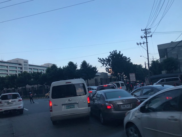
 Morning rush traffic starts very early these days. This photo was taken around 6AM on a Thursday along the westbound direction just after the Manggahan Bridge. The pedestrian overpass at C. Raymundo junction is shown and the dark colored buildings are at Robinsons’ Bridgetown development. Note the commuters along the right waiting for a ride.
Photos paint a thousand words. The Taytay Mayor attended the meeting. He has been under fire for the horrendous traffic caused by the mismanagement of Tikling Junction as well as the Barkadahan Bridge area that was and is supposed to be a major alternative route for Rizalenos heading to their workplaces in Makati and BGC. More recently, there were posts about the traffic signals installed at Tikling Junction that basically invalidates the roundabout concept for the junction. The result last Thursday, the first day of operations for the signals, was hellish traffic that backed up a couple of kilometers along the Manila East Road and Ortigas Ave. Extension (some reports say until Cainta Junction). This, even as the signal settings were supposedly done with help from the MMDA.
Antipolo was represented by its former Mayor and husband to the current one. He also happens to be a former Governor of the Rizal Province and likely to run again as his mother, the current governor, is on her 3rd term. It seems to me that the province is not so interested in solutions for Ortigas Avenue despite most of its constituents traveling through the corridor to get to their workplaces and schools. Marcos Highway is not the main corridor for Rizal towns as it basically carries only Antipolo and maybe some of Tanay (via Sampaloc) traffic. Ortigas Avenue Extension branches into two major roads from Tikling – Ortigas Ave Extension, which ends at the capitol, and the Manila East Road, which connects to practically all of Rizal towns with San Mateo and Rodriguez (Montalban) being the exceptions. It is time for the province to pay attention to this commuting problem experienced daily by her constituents.
The Mayor of Cainta seems not as interested as the others, sending a representative who appears to be not one of the top officials (the traffic chief with a rank of SPO1=Master Sergeant is lower ranked than a councilor) of the Municipality to such an important meeting. In fact, he is currently now embroiled in a controversial faux pas involving himself by not wearing a helmet while riding a motorcycle. What’s more is his downplaying this and appearing to be even justifying the act. He eventually apologized but not before stating his moves. He is not new to publicity (stunts?) and knows how bad publicity still translates to good publicity especially in this days of fake news and trolls (he apparently has many on social media). He seems to forget that transport and traffic solutions for Ortigas Ave will likely benefit anyone seeking reelection or higher office in Rizal. He is on his last term as mayor and the break-up with some of his allies including his former Vice Mayor who ran against him in the last elections shows the limits of his political career. What was rumored as plans to run for Rizal governor might just be downgraded to perhaps Vice Mayor? In any case, he should show more interest and effort in finding solutions beyond traffic management and not by himself but in cooperation with others with whom his jurisdiction shares the problems with. Perhaps the initiative of the Pasig Mayor presents an opportunity for such cooperative work? Many people are very interested in this and will be watching – and hoping.
–
Ortigas Center congestion
A couple of Thursdays ago, I was in the Ortigas CBD area to attend a conference on statistics. I hitched a ride with an old friend who was also going there and so we had some time to catch up on life and other topics we usually talked about since our college days. Being on the passenger seat also meant I had some opportunities to take photos of the traffic situation in the vicinity of the venue of our conference. Here are some photos I took of traffic in the Galleria – ADB area as we drove along ADB Avenue.
 Congestion along ADB Avenue across from Robinsons. The ADB building is shown ahead of the vehicles.
 Most of the vehicles turned out to be turning towards Guadix and headed for Poveda. These are traffic generated by the exclusive school where most if not all students’ mode of transport is by car. This causes much of the congestion in the area at this time of day as well as during dismissals in the noontime and afternoon.
 Vehicles bound for Poveda (building is in the background) and EDSA.
 View of Ortigas bound vehicles filed along Sapphire Road – this photo was taken at the bridgeway connecting Crowne Plaza and Holiday Inn. The relatively uncontested road is the Robinsons’ driveway.
The photos show how dependent to cars many people working in the Ortigas CBD are. Many of them live outside of the CBD including those residing in the Rizal towns to the east of Metro Manila. The number of people using their own cars put so much strain on the major thoroughfares including and perhaps especially Ortigas Avenue, which serves as a main arterial connecting the CBD to many parts of Pasig, Quezon City (via C5) and the very progressive towns of Rizal Province such as Cainta, Taytay and Antipolo City.
It is a wonder why up to now, there is no mass transit system along Ortigas Avenue when the demand is very high and continuous to increase with the development of lands along it. SM, Robinsons and Megawide are among the major players now developing their plots of land to become high density commercial/office/residential areas. And these will surely translate into more trips generated and worse traffic congestion. Perhaps the mayors of Pasig, Cainta, Taytay and Antipolo plus the governor of Rizal can get together to discuss and agree about solutions where each LGU can contribute for the betterment of their constituents’ commutes?
–
The Barkadahan Bridge situation
The Barkadahan Bridge is currently undergoing rehabilitation. To be accurate, the old bridge is being rehabilitated and upgraded/retrofitted to be able to carry the traffic projected to use it being a vital link between the Province of Rizal and Metro Manila via Pasig and the C-6 corridor. The bridge is named after the “friendship” established among Rizal municipalities and Pasig City for an area that has been subject of a territorial dispute among them. These are the municipalities of Cainta and Taytay (Rizal Province) and the city of Pasig. The bridge spans the Manggahan Floodway, much of which is in Pasig City.
To increase the capacity for this crossing, which is the most direct route to C-6 and popular among many headed to Taguig/BGC and Makati, a new bridge had been constructed to the south of the old one. The older one had 2 traffic lanes and was no longer sufficient for the volume of vehicles crossing it after the expansion of C-6 resulting to it steadily gaining more users over the years. Use of this route cut down travel times between Rizal and BGC and Makati by at least 30 minutes based on our experiences using the route.
Late last year as far as I could recall, the new bridge opened and immediately increased capacity but then congestion quickly set-in due to two factors: the traffic management at the intersection with the East Bank Road and the constrained (two-lane, two-way) leg of Highway 2000. Add to this the lack of discipline by local traffic in the form of tricycles and motorcycles counter-flowing in the area.
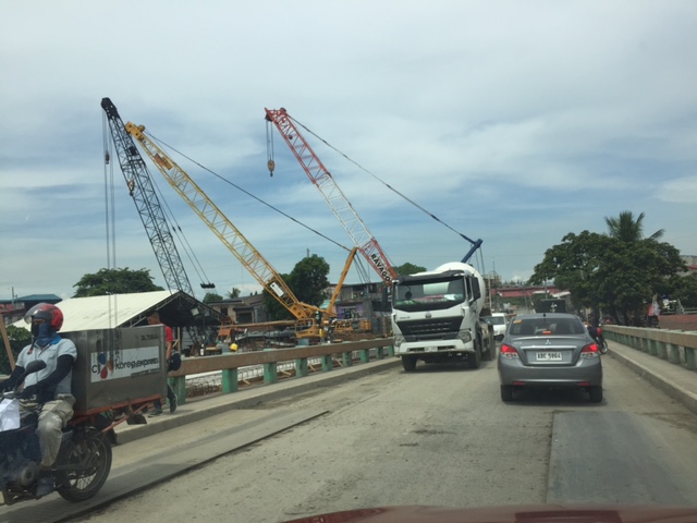
Earlier this year, signs were posted around Rizal about the then impending project for the rehabilitation of the old bridge. The signs advised for most travellers to avoid using the Barkadahan Bridge due to the congestion in the area because of the project. It turns out that what was thought by most as a project retrofitting the old bridge alone was actually a bigger one involving increasing the capacity of the Highway 2000 leg of the intersection with the East Bank Road. Following is a photo posted at the official Facebook page of the Rizal Provincial Government showing the demolition of buildings and other structures along the Highway 2000 leg. The photos were taken from the new Barkadahan Bridge approaching the intersection, the southbound direction of the East Bank Road, and from the westbound side of Highway 2000.
 Demolition and clearing of ROW for the expansion of Highway 2000 in relation to Barkadahan Bridge [Photo collage from the Lalawigan ng Rizal Facebook page]
From the photos above, it is clear that at least 2 lanes will be added to Highway 2000 and that this leg will soon be well-aligned with the Barkadahan Bridge, which will also have a total of 4 lanes. Hopefully, this project will be completed soon and within the year (before December?) in order to alleviate the commuting woes of Rizalenos working in the BGC and Makati CBD areas. Of course, that goes without saying that there is also a need to optimise the traffic signals at the intersection and to strictly enforce traffic rules and regulations vs. erring motorists in the area.
–
On the traffic flow predicament at Tikling junction…again
During weekends, a constant frustration have been the incidence of severe traffic congestion along Ortigas Avenue Extension. Weekday evenings are usually better in terms of traffic compared to Saturdays. But last Monday, the congestion was so severe the congestion reached Valley Golf and vehicles had to crawl to Tikling. As mentioned in previous posts on this subject, part of the problem is the sheer volume of vehicles that make the roundabout set-up inappropriate for the junction. Then there is also the issue about the people who are supposed to manage traffic but end up mismanaging it. From what I usually observe, they tend to favour vehicles coming from Taytay via the Manila East Road leg and seem oblivious to the build-up of traffic along Ortigas Ave. Ext. eastbound.
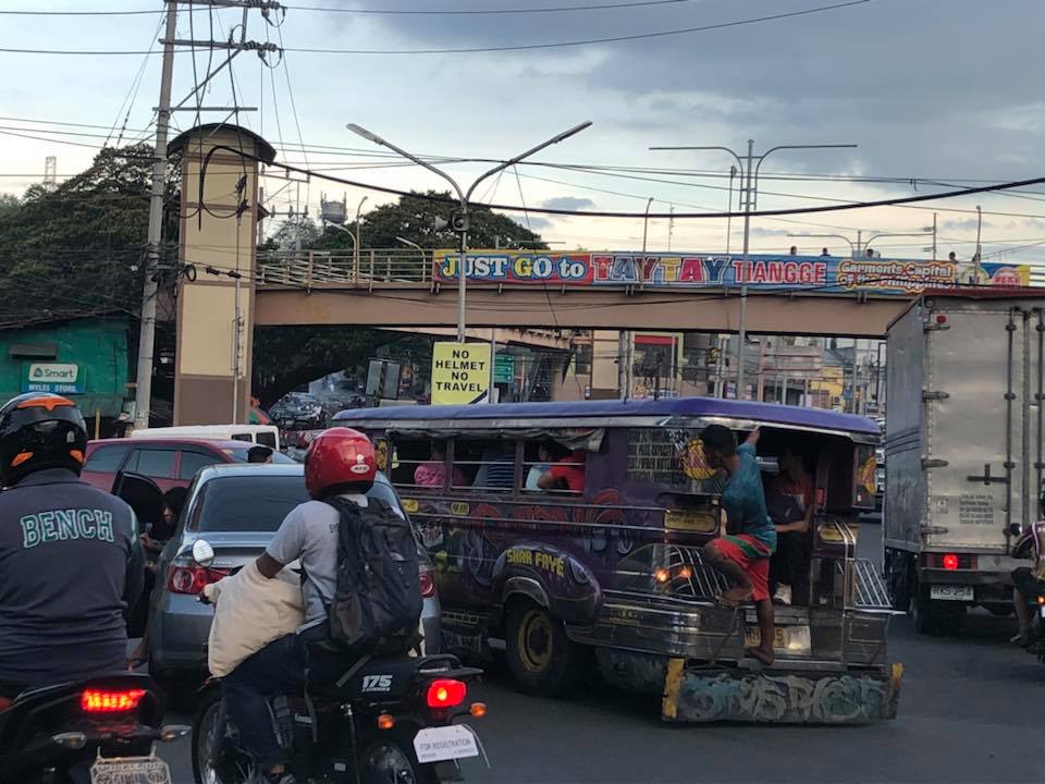 Typical heavy traffic at Tikling Junction
We might finally get a chance to have a solution for this. One of our students took on a topic that will require her to asses the traffic at the intersection to determine, for example, whether the roundabout is suitable or perhaps should be changed into a signalised traffic control. Both analytical approach and microsimulation (using Vissim or the homegrown LocalSim) will be employed. But we will have to wait by May to see some substantial results.
–
C-6 expansion and upgrading on the way…
The opening of the second Barkadahan Bridge prodded me to post something about C-6. It is a work in progress but currently you can see the progress that is quite noticeable unlike before. Here are a couple of photos we took while en route to BGC last weekend.
 Ongoing paving along C-6 for the westbound side of the highway. The photo shows recently completed PCCP slabs for 2 lanes. Forms are visible in the photo.
 Other sections have had their base compacted and ready for concrete pouring.
As a regular user of C-6 since 2014, I am one of those who look forward to the completion of its expansion and upgrading. There is also something to look forward to for cyclists and pedestrians/joggers/runners as there is a wide bikeway and segregated walkway being constructed along the side of right side of the future eastbound side of the highway. This should encourage non-motorised traffic along this corridor that directly connects Taguig, Pateros, Pasig and Taytay and extends to serve the southern part of Metro Manila, Makati City and the province of Rizal.
–
The newly opened 2nd Barkadahan Bridge
A new bridge had been under construction beside the older Barkadahan Bridge. Instead of expanding the existing bridge, the proponents decided to build another bridge likely so as to reduce disturbance of traffic along the already congested first bridge. This is the same strategy for the bridge across the Pasig River in Nagpayong/Napindan that will reduce the potential bottleneck for when C-6’s expansion is completed. Unfortunately, the bridges don’t seem to include provisions for exclusive bicycle lanes that are clearly incorporated along much of C-6.
 I took this photo as we were in queue at the approach to the intersection of Highway 2000 and the Manggagan Floodway’s East Bank Road. The new bridge can be seen here bearing eastbound traffic. The alignment at the intersection has not been addressed and so requires through traffic to basically swerve towards the entry to Highway 2000.
 Here’s the intersection and the newly opened bridge. Note the vehicles coming towards my position as they follow a trajectory from the bridge to the narrow exit leg of Highway 2000.
 Instead of a single lane along each direction, the two bridges now allow for at least 2 lanes of traffic either way. I say at least because a case can be made for 3 lanes to be indicated (there are no lane markings yet). The issue here though is that there is significant truck traffic crossing the bridge and two trucks traveling beside each other easily occupies the entire bridge. Thus, maybe a wide two lanes can be designated for both bridges with an opportunistic third lane forming depending on the traffic.
–
Some issues at Barkadahan Bridge
Perhaps one of the worst places to be in terms of traffic during the morning peak is Highway 2000, and particularly the approach to the Barkadahan Bridge that crosses the Manggahan Floodway. Traffic management at the intersection of the East Bank Road and Highway 2000 is so atrocious that everyone passing the junction would likely incur delays of more than 30 minutes.
The congestion in the area is also attributable to the fact that you have major roads carrying traffic from all over the eastern town of Rizal that are bound for Makati and Taguig (Bonifacio Global City), mostly for offices in those CBDs. These commuters likely use the completed C-6 sections including those at Lupang Arena and the expansion along the Laguna de Bay coast.
 Barkadahan Bridge is a 2-lane structure with significant local traffic such as the tricycles in the photos
 On either side are narrow walkways and it no uncommon for people to walk on the carriageway itself .
 The bridge’s expansion is underway but, from my observation, is taking too much time. Perhaps the contractor is having problems with the foundations for the posts? Or maybe the funds aren’t flowing as required for the effective implementation of the project?
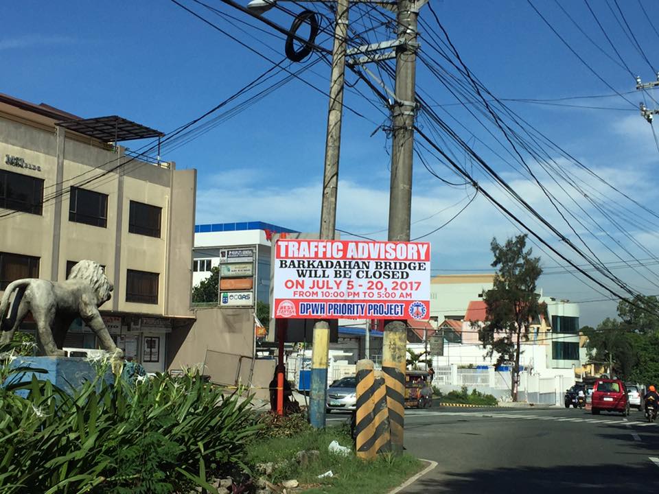 This is an ‘old’ sign now as July 20 is already more than a week ago.
A lot of people look forward to the completion of the bridge but the bigger issue is still the traffic management at the intersection that is also influenced by factors such as the tricycle terminal near the junction and the undisciplined local traffic. The situation is exacerbated by those who counter flow along Highway 2000 and generally get away with it. Perhaps the Municipality of Taytay should get some help in improving their capabilities for traffic management?
–
Some updates on C-6
I have not used Circumferential Road 6 in a while. And so a couple of weeks ago, I was happy to see that work has resumed on the sections at Lupang Arenda in Taytay, Rizal, which is also known as Sampaguita Street. Here are some photos of the wide C-6 section. I guess there’s an opportunity here to have service roads on either side of the highway in order to manage/control local traffic. C-6, after all, is a highway and is designed for typical national highway speeds (i.e., 60 kph). The adjacent land use, however, requires slower traffic mainly due to safety concerns.
 Cordoned-off section where a contractor is preparing the sub-base prior to placing the steel reinforcement and pouring concrete
 Another photo of the section showing form works for the slab. Note the parked vehicles along the side on the left.
 Some sections are already flooded from the heavy rains
 The completed section towards Nagpayong, Pasig is a wide 4 lanes. At left is a nice view of the Laguna de Bai.
 Section to Nagpayong near the boundary of Taytay, Rizal and Pasig City.
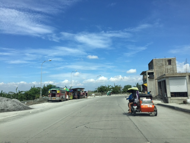 That’s a habal-habal (motorcycle taxi) terminal on the left and in front of a parked jeepney.
Two very important things about C-6 though. One concerns the Barkadahan Bridge over the Manggahan Floodway, which is too narrow for the traffic that cross it. There’s a new bridge beside it that seems to be taking too long to build. And then there’s the long stretch from Nagpayong, Pasig to Lower Bicutan, Taguig which remain in bad condition. The new section along the lakeside is already usable for Pasig-bound traffic but needs to be allowed to carry two-way traffic for the older section to be rehabilitated. C-6 is becoming a major alternative route for a lot of travelers from Rizal to and from Makati and Taguig (esp. BGC). It needs to be improved immediately as it can help decongest the Ortigas Ave. – C5 route that most Rizalenos use to go to their workplaces.
–
Opposition to C-6
There had been no significant developments for the Circumferential Road 6 (C-6) not counting the road widening and concreting along the sections at Lupang Arenda in Taytay, Rizal. Meanwhile along its lakeside alignment in Taguig, a 2-lane road has been constructed apparently as part of the widening of the section for what maybe a future 4-lane road with a median island dividing opposing flows of traffic.
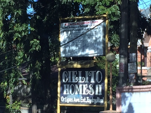 Sign apparently put up by this residential subdivision’s homeowners’ association
 Close-up of the sign shows opposition by the residents to the proposed C6 alignment to pass through their homes.
I haven’t heard or read about anything new or updates about C-6. It seems to be tied to other projects including a proposed elevated tollway along the shores of the Laguna de Bay. The alignment though to the north seem to be unresolved and will definitely be a big concern for many developed residential areas including those in the Province of Rizal.
–
Improvements to alternative route between Rizal and Makati
I finally got another look at the conditions along the alternate road to Highway 2000 and C-6 Extension a couple of weeks ago while en route to Bonifacio Global City. Traffic along Ortigas Ave. is usually terrible these days even during the weekends due to the road and drainage works between Cainta Junction and Brookside. I am glad to say that there have been significant improvements to the section of Don Hilario Cruz Ave nearest to the Manggahan Floodway and beside the Megawide plant. There have been significant developments, too, along C-6 Extension in the Lupang Arenda area of Taytay, Rizal. Here are some photos of the area.
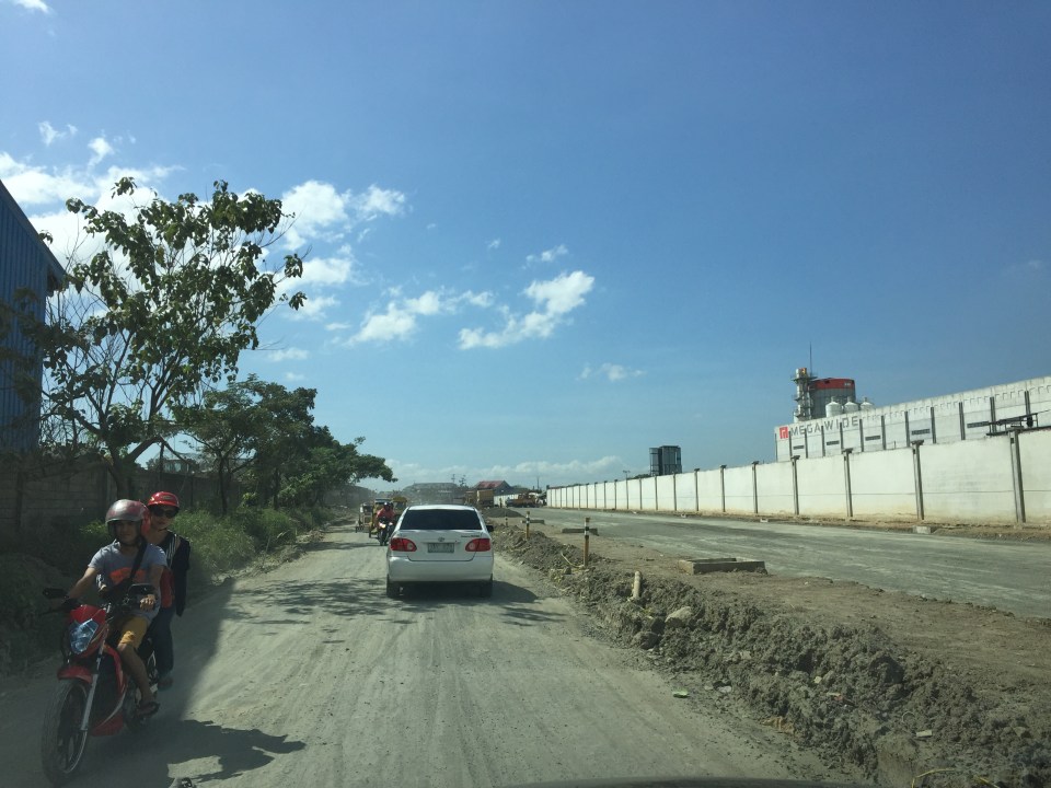 Don Hilario Cruz Ave., the road beside the Megawide plant and parallel to Highway 2000, is being improved with half the carriageway already prepared for paving. The other half appears to be graded is being used by vehicles.
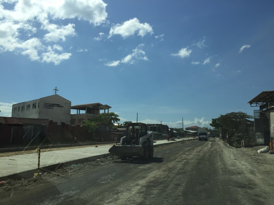
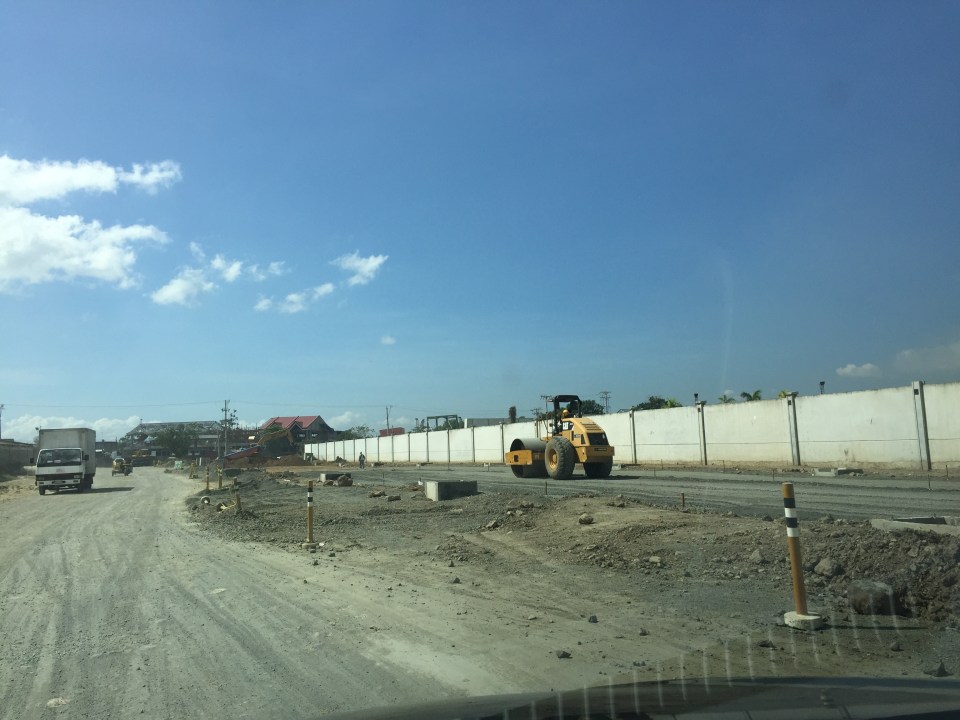 A roller runs along the base layer of the road that’s being paved. These sections were usually muddy and full of craters during the wet season and very dusty and still full of potholes during the dry season.
 Sections of C-6 Extension at the Lupang Arenda area have been widened and the expropriated lands are now being transformed into paved roads. The original sections have been overlayed with asphalt to improve their ride-ability.
 Another section in Lupang Arenda shows finished PCCP for the eastbound side of C-6.
 Another photo of C-6 extension. Once the finished lanes are usable, authorities will probably divert traffic there so they could also pave the rest of the road.
Travelers between Rizal and Makati/Taguig will benefit the most from the improvements along these roads. These will increase road capacity as well as travel speeds along this route. Now, if only authorities can also improve C-6 itself in Taguig…
–
