
Home » Posts tagged 'traffic management' (Page 3)
Tag Archives: traffic management
A real battle of Katipunan – the search for a transportation solution
Is it obvious that I was alluding to the classic match-ups of the two major universities – Ateneo De Manila University and the University of the Philippines Diliman – that are located along Katipunan Avenue for the title of this article? That is deliberate on my part as there is a ‘real’ battle along Katipunan Avenue, and it does not involve sports.
Following is a recent article from the Philippine Collegian that reports on the current state of traffic along the corridor:
https://phkule.org/article/971/private-cars-mainly-to-blame-for-katipunan-traffic-transport-experts
I have written before and many times about transport and traffic along Katipunan Avenue. This road has been part of my daily commute since 1988 when I was admitted to UP Diliman as a B.S. Civil Engineering major. Back then Katipunan was not as wide as it is now, especially along the section between UP Diliman and the MWSS complex. That section only had 2 lanes then. What is not a wide center island with large, old acacia trees used to be the frontage of MWSS. So now you can probably imagine how much land was ceded by MWSS for road widening.
I also wanted to write about Katipunan in part as a sort of farewell to the former MMDA Chair and Marikina Mayor Bayani Fernando (BF), who recently passed away. Much of how Katipunan looks like and the traffic situation today can be traced to what transpired during his time at MMDA. I will refrain from writing about this and him for now. I am actually thinking of writing a series about BF and his time as Mayor in Marikina, as MMDA Chair, and his brief stint as DPWH Secretary. This short article will do for now.
A zipper lane along Katipunan?
Yesterday, the Metro Manila Development Authority (MMDA) started another experiment along Katipunan Avenue in Quezon City. They introduced a zipper lane along the stretch fronting Ateneo’s Gate 2 and Miriam College’s main gate (about 740m – less than a kilometer). This single lane was supposed to ease traffic congestion along the northbound direction of Katipunan (aka Circumferential Road 5 or C5 or Pres. C.P. Garcia Avenue), which is saturated with vehicles especially during the morning peak.
While we wait for the official pronouncements regarding this experiment, the impacts are likely to be marginal as the original northbound lanes are jammed with vehicles. Thus, there is a tendency for the entry to the zipper lane to be blocked. MMDA staff will also have to stop vehicles at the exit if they will allow the movement of left-turning and U-turning vehicles at the junction with B. Gonzales and Miriam’s main gate. While it may seem an exercise in futility, we have to appreciate the continuing effort of MMDA for such schemes. The bottomline though is the MMDA has limited options to address the hellish traffic along Katipunan. The schools and other establishments would need to put their heads together to formulate a more sustainable solution for this corridor.

Why do we keep widening roads?
I’m just going to share this article here. The article from The NY Times asks a question that has been bugging planners and engineers, particularly those who are in government and perhaps under the agencies like the DPWH, DOTr and NEDA. This also applies to planners, engineers and those from other disciplines involved in transportation infrastructure development and particularly roads or highways.
–
The return of carmaggedon and the illusion of low vehicle ownership
Traffic seems to be back to pre-pandemic levels in the Metro Manila and its adjacent provinces. You can experience this along major roads like Commonwealth Avenue, C-5 and yes, EDSA. The number of vehicles on the roads including motorcycles defy what is supposed to be low motor vehicle ownership in Metro Manila (as claimed by DOTr and JICA in the MUCEP report and echoed by groups who cite the report as if it is flawless).
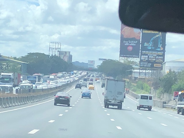
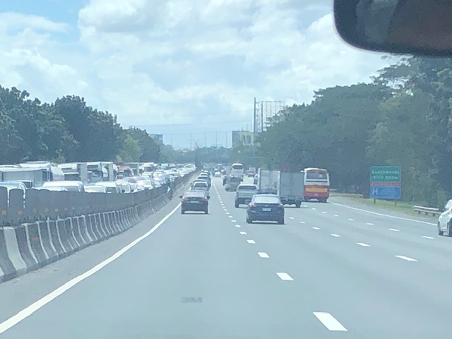
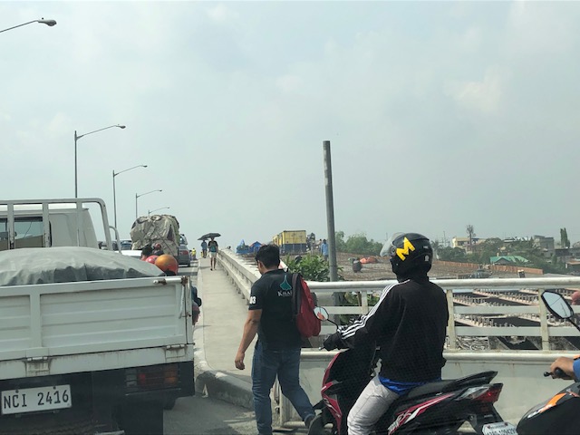
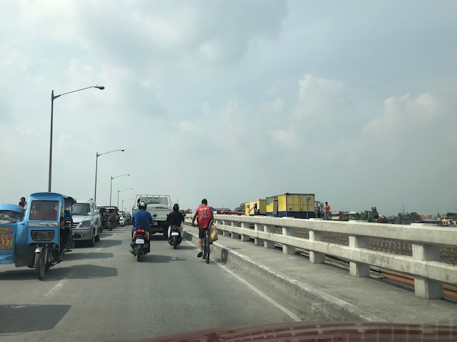
 Intense traffic congestion along C5/Katipunan Avenue. The photo shows traffic on the C5/Katipunan flyover’s northbound side and towards the direction of Ateneo, Miriam and UP Diliman.
The reality appears to be that more households actually own motor vehicles and the inefficiencies and unattractiveness of public transport continues to convince people to take private transportation, including motorcycles, over public transport options. The inconvenient truth according to one senior transport expert is that while cycling has gained ground, the numbers are minuscule compared with those taking either private or public motorized transport. Yes, carmaggedon is back and looks here to stay for a while longer until the so-called game changers like the MM subway and Line 7 are operational. Will they change the commuting behavior or are these too late in as far as solutions are concerned?
–
On addressing global warming
Here is another quick share of an article; this time on “warming”. The evidence for global warming is strong and we need to address this pressing issue if future generations are to survive a planet that is heating up fast.
Litman, T. (August 31, 2022) “Cool Planning for a Hotter Future,” Planetizen.com, https://www.planetizen.com/blogs/118535-cool-planning-hotter-future?utm_source=newswire&utm_medium=email&utm_campaign=news-09012022&mc_cid=ead7ee914a&mc_eid=9ccfe464b1 [Last accessed: 9/5/2022]
To quote:
“Many of these strategies provide significant co-benefits. For example, reducing road and parking supply with more efficient traffic and parking management helps reduce infrastructure costs and traffic problems, and by reducing impervious surface area it reduces stormwater management costs. Planting more urban shade trees helps create more attractive neighborhoods and increase wildlife habitat. Improving natural ventilation creates more comfortable and healthier buildings, as summarized below.”
I recall people calling for more trees to be planted along roads and how our city streets can become something like Orchard Road in Singapore. I agree with having more trees and other plants, landscaping, along our roads. I also lament the times (and it continues) when the DPWH chopped so many old trees along national roads for road widening projects that didn’t need to destroy so many that gave those roads shade as well as character. We need more change in mindsets particularly when we design highways and streets towards sustainability and yes- reducing heat.
–
Article on people-oriented traffic management
Here’s a quick share on a topic that is also very relevant especially for local government units – traffic management. To quote from the article:
“Today, when the mobility of Filipinos is severely constrained by limited public transport capacity, …and when there is heightened pressure for private vehicle use, there is no better time to re-orient traffic management in the Philippines in order to prioritize inclusive, efficient and environmentally sustainable travel modes. The crucial ingredient is not infrastructure but political will.”
Siy, R.Y. (January 8, 2022) “People oriented traffic management,” Mobility Matters, The Manila Times, https://www.manilatimes.net/2022/01/08/business/top-business/people-oriented-traffic-management/1828593 [Last accessed: 1/8/2022]
The article makes perfect sense as traffic management in the country has always been car-oriented including the strategies, policies, schemes, measures and others that have focused on facilitating private car travel over active and public transport modes. The challenge here is how to bring this up front and an election issue at both national and local levels.
–
On ‘electric cars’ still being ‘cars’
With the current climate talks in the background, there is also a parallel discussion on the impacts of electric vehicles and self-driving cars. Will they help solve our transport or traffic problems? Perhaps e-cars will contribute to the reduction of emissions and greenhouse gases. Perhaps they can also help in reducing dependence on fossil fuels. But can they alleviate congestion? Or will they just promote more car-dependence? Here’s a nice article from early this year that discusses the “big problem” with electric cars:
I also read another article about the issues concerning the batteries (e.g., lithium batteries) used by these e-vehicles. We are only beginning to see how difficult it is to deal with the waste of used batteries not just from e-vehicles but from other sources as well. Renewables like solar, for example, requires batteries for storage. These are issues that need to be addressed ASAP. Otherwise, it will be a losing proposition for people in general as they end up with modes of transport that are not sustainable for the future. Perhaps we can just walk or bike?
–
SLEX congestion
En route to Batangas the other day, we had to endure severe traffic congestion along C5 and SLEX. C5 was at its worst as it took us about 2 hours from Blue Ridge until SLEX. Descending from the flyover to SLEX, we were greeted by crawling traffic along the tollway, which was to us a slight surprise for the southbound direction. Normally, traffic would already be lighter compared with the northbound side that carried peak hour travelers inbound for Metro Manila.
Much of the ‘additional’ congestion along SLEX is attributed to the ongoing construction of the Skyway extension. Traffic management is particularly criticized and congestion very atrocious at Alabang on ground level beneath the viaduct. Buses are prohibited from using the viaduct and the traffic schemes have contributed to severe congestion. Through traffic along both sides of the tollway have been affected, too, with queues reaching Laguna.
 Preview: Passing the Alabang area, we observed that the queue from Alabang already stretched beyond what is visible to the eye.
 No end in sight: this is what we usually describe as a traffic jam condition with the density reaching its maximum value and speed at its lowest. Volume approaches zero for this case.
 Horizon: The queue that morning reached the Southwoods exit of the SLEX. Approaching northbound travelers would have to endure severe congestion until Alabang.
On hindsight, I thought that we should probably have opted to fly between Quezon City and Lipa City. My colleague said that the contact person offered that option to us but that he turned it down because he gets dizzy riding helicopters. I wouldn’t know as I’ve never ridden on one. However, we also thought it wouldn’t be prudent for us to ride a helicopter from the university. It would seem to be the transport of VIPs and easily attracts unwanted attention. Yet, it would have been the more practical and speedy if not the less expensive option for the trip that day.
The problem with public transport in the Philippines…
There is a collage of two photos, one taken in 1975 and another in 2019, showing buses that managed to squeeze themselves into a jam. The 1975 photo was taken at the ramp of the overpass near Liwasang Bonifacio (Quiapo, Manila). There is a commentary describing the photo that attributes ‘monstrous daily traffic jams’ to the behavior of Filipino drivers. Special mention was made of public transport drivers and the photo showed proof of this. This was 1975 and motorization had not reached the levels we are at now so the arguably, traffic congestion was not as bad as the present we experience daily.

The problems pertaining to driver behavior persist today and probably even worsened along with the general conditions of traffic in Philippine roads. I say so since the volume of vehicular traffic has increased significantly from 1975 to the present and there are much more interactions among vehicles and people that have led to a deterioration of road safety as well. Traffic congestion and road crashes are asymptomatic of the root causes of most of our transport problems. And so far, it seems we have had little headway into the solutions. The photos speak for themselves in terms of how many people can easily put the blame on poor public transport services despite the fact that cars are hogging much of the road space. And what have authorities done in order to address the behavioral issues that lead to these incidents?
Someone joked that the guy in the 1975 photo who appeared to be posing in disbelief of what happened is a time traveler. The 2019 photo shows a similar guy with a similar pose though with more people around. Maybe he can tell us a thing or so about what’s wrong with transportation in the Philippines and provide insights to the solutions to the mess we have.
–
Status of Barkadahan Bridge, Taytay, Rizal
I recently wrote about the Barkadahan Bridge and its current state and compared it to the Marcos Highway Bridge that is now completed and fully opened to travelers. Unfortunately, I didn’t have photos to share but only shared my observations based on what friends have told me and what I’ve read on social media (i.e., Rizal Provincial’s and Taytay’s official Facebook pages) about the situation there. I finally had the opportunity last Sunday when I went to fetch my family at the airport. Here are photos of the Barkadahan Bride and its environs. Note that Barkadahan is actually two bridges and not one. The new one is currently being used for two way traffic (one lane each) while the second one is under rehabilitation and retrofitting. The latter had and will have 2 lanes, too.
 Approach to the Barkadahan Bridge via Highway 2000 – notice the widening on the south side of the highway? That’s the ROW expropriated to align the bridge(s) with the highway. Ultimately, this should be of the same width as C-6.
 Closer to the bridge, you see more of the ROW acquired to improve the geometry for the area and the intersection with the East Bank Road. Highway 2000 is now aligned with the second (newer) bridge constructed that will eventually carry only the eastbound traffic. The older bridge currently being rehabilitated and retrofitted will carry the westbound traffic.
 Vehicles crowd on the two-lane bridge that is the new Barkadahan Bridge. The old one is currently being rehabbed. Notice the significant volume of trucks using the bridge? This is expected to increase due to the industrial developments in Rizal Province and along C-6, and the direct route this corridor provides towards the SLEX via Bicutan.
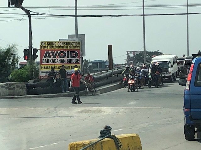 Big sign at the bridge – there are many of these scattered around Pasig and Rizal advising travelers against using the route and Barkadahan Bridge because for the construction work on the bridge. This ‘avoidance’ basically transferred (some say returned) much of the traffic to Ortigas Avenue Extension. Many if not most users of the bridge use this alternate route to travel from Rizal to BGC and Makati CBD.
 A peek at the construction work on the old bridge – note that the contractor seems to have completed installing the steel reinforcement for the slabs for this section of the bridge. The next phase would be the concrete pouring.
 Still another peek showing the extent of the work on the old bridge – my casual observation of the work areas was that there seems to be not so many workers. But then maybe it was a Sunday? Perhaps there should be more people working considering this is a very urgent project?
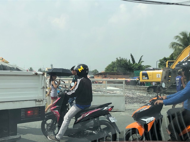
 Tricycles, motorcycles and bicycles – there’s a lot of local traffic using the bridge and these are represented by mostly tricycles serving the residential and commercial areas along the East and West Bank Roads and the cyclists you most often see crossing the bridge. Most motorcycles are through traffic. On weekends one can observe more recreational cyclists as this route is a popular one to Rizal and particularly its mountainous areas that are popular to mountain and road cyclists.
 Counterflow – many motorcyclists tend to counterflow and this adds to the friction and slows down traffic. Once the other bridge is completed and re-opened, these will likely be reduced to lane splitting or filtering as the opposite flows of traffic will be assigned to separate bridges. Counterflow traffic will then be very obvious and should be apprehended.
 Here’s the resulting queue on the other side of the bridge. This is severe congestion that reaches C-6. Note that the photo was taken on a Sunday. Perhaps these travelers have no other option but to use this route so they are stuck in hellish traffic on a Sunday? I can only imagine how worse it is on weekdays.
As a parting shot, I think there are still a couple of things that need to be addressed once the bridges are both open to traffic:
- Optimizing traffic management at the intersections with the East Bank Road and West Bank Road of Manggahan Floodway – the (mis)management of traffic here also contributes to congestion in the area. Traffic enforcers on both ends of the bridge have basic knowledge of how traffic must be managed and end up with the “buhos” approach. They don’t seem to be coordinating with each other, too. Their approach also heavily favors the East and West Bank roads when traffic is heavier along the main corridor that is C-6/Highway 2000. There needs to be a more efficient way to manage traffic here and that may be in the form of a sophisticated traffic signal system at least for the two intersections. Settings need to be studied and signals have to be adaptive to the variation of traffic throughout the day.
- Resolve bottlenecks in the area including structures that tend to reduce capacities of the approaches to the bridge.
More on this topic soon!
–
