
Home » Posts tagged 'transport plans'
Tag Archives: transport plans
When Driving Isn’t an Option: Steering Away From Car Dependency
Here is another quick share of an article from Planetizen. The article relates about people who cannot drive so driving for them is not an option:
Source: When Driving Isn’t an Option: Steering Away From Car Dependency
Quoting from the article:
“Zivarts shows that it is critical to include people who can’t drive in transportation planning decisions. She outlines steps that organizations can take to include and promote leadership of those who are most impacted—and too often excluded—by transportation systems designed by and run by people who can drive. “
There are actually many who can drive and who would like not to drive but then opt to drive because of limited and inconvenient or uncomfortable options. I think government agencies and local government units are supposed to work on this but like people who try to ‘solve’ traffic by isolating it from other factors such as housing, they ultimately gain little ground if not fail. It doesn’t help that the decision makers such as government officials and politicians drive or are driven. Of course, there is still such a thing as empathy so let’s not discount those who do use cars for their commutes but also work hard to improve transportation. It’s just that such people are rare these days and may not be in a position to move things to enable significant improvements to the transportation system.
–
On urban planning resources or references for the pandemic
I am posting for reference this article compiling helpful references for urban planning in the context of the COVID-19 pandemic. Most of the references listed are based on the US experience and I am sure there is already a wealth of information coming from other countries as well including those that have been successful in mitigating the effects of the pandemic.
Brasuell, J. (2020) “Urban Planning Resources for COVID-19”, Planetizen, https://www.planetizen.com/node/109238?utm_source=newswire&utm_medium=email&utm_campaign=news-05142020&mc_cid=2e155996b6&mc_eid=9ccfe464b1 [Last accessed: 5/16/2020]
–
A new transport planning process?
December’s already “Chrismassy” in our part of the world and so in keeping with the spirit of Christmas, here is another article I am sharing:
Polzin, S. (2017) “All I Want for Christmas is a New Transport Planning Process,” Planetizen.com, https://www.planetizen.com/node/96036?utm_source=newswire&utm_medium=email&utm_campaign=news-12042017&mc_cid=e64f0c0c60&mc_eid=9ccfe464b1 (Last accessed: 12/6/2017)
In school, we’ve been taught and are still teaching many of the old concepts of transportation planning. I believe these are still important and relevant especially since the fundamentals, or the basics if I may say, are still needed in many situations around the country (i.e., the Philippines). The article above is relevant to our case because it helps build awareness of what is now being discussed and what the future will bring to us. That future for transport is not necessarily immediate although there are already pressures coming from various sectors and technology has been key to the disruptions and the leapfrogging we are experiencing. I like what a friend opines overtime he gets the chance. That is, that the technology-push is not the solution to a lot of our problems because we cannot ignore the basic deficiencies in our transportation system that technology alone cannot overcome.
–
What if Manila decided to build its first subway back in the 1970s?
There is something about the counterfactual that is attractive to me. While I do not have formal training as an historian, I like to dabble in history and particularly about the what-could-have-been. It started with a book I read about counterfactual military history with various articles written by prominent historians who put forward scenarios including that on Thermopylae, Pearl Harbor, and the Vietnam War. I have found it a good exercise in analysis that is along the lines of chess analytics where one move may lead to another in response. Applying this to transport was quite a natural thing and we take a look at some information from the Feasibility Study for what was proposed in 1973 as the first subway line for Metropolitan Manila.
 Proposed schedule for the 3-stage construction of RTR Line 1, most of which would have been a subway connecting Diliman, Quezon City with the University Belt in Manila and ultimately the airport in Paranaque.
Stage 1 between UP and FEU could have been operational as early as 1983 but typical delays could also have led to service starting in 1984 or even later. According to some critics of the LRT Line 1 that was built instead of the RTR Line 1, Marcos decided against the subway after being convinced by his advisers that the line could not be completed before Singapore finishes its own first line. A story is told that Marcos didn’t want Lee Kuan Yew to have the satisfaction of having Southeast Asia’s first mass transit line so the former opted for the elevated LRT instead. What really happened though was Singapore started operating its SMRT North-South Line in 1987, after what was also a long period of planning, decision-making and construction. It can be argued that the Philippines could still have completed at least 10 kilometers of the RTR Line 1 and at most 15 kilometers by 1987. Even a revolution in 1986 could not have doomed this project given its benefits that we could have reaped over the long-term.
 Proposed stages of construction for the RTR Line No. 1 – whichever alternative could have led to the completion and inauguration of a substantial segment by 1983/84, well ahead of Singapore’s first line.
 Artist’s conception of what an RTR Line 1 platform could have looked like. The trains look like a typical Tokyo Metro train. There’s some humor here as you can see the route map at right and the direction sign at top left referring to the Manira (Manila) Air Port.
As you can see in this rather simple (note: not included are discussions on the financial & economic aspects of this project) exercise, Metro Manila could have constructed the RTR Line 1 more than 3 decades ago. Even with the political upheavals in the Philippines during this period, it can be argued that Marcos and his version of the “best and the brightest” could have pulled it off and come up with the country and Southeast Asia’s first subway line. Most of the decision-making, planning and construction would have been during Martial Law when the Marcos had quite a firm grip on power. So he and his apologists have no excuse for this failure to potentially revolutionize transport and take Metro Manila to the next level in terms of commuting. That failure ultimately led to the current transportation situation we have in what has grown to become Mega Manila.
–
On the transportation aspects of Antipolo’s pitch for the senate to relocate there
I was browsing Facebook the other day and found an interesting post by the Antipolo City Government’s official account. They posted about the presentation made by the current mayor to the staff of the Philippine Senate, selling the idea for the Senate to relocate from its current location in Pasay City. There are currently two options known to us: Fort Bonifacio in Taguig City and Antipolo City in Rizal Province.
The Antipolo government’s post stated that it only takes 25 minutes between the the Batasan Complex and the proposed site, which is on land owned by the Antipolo City Government. This was probably based on travel time estimate using a tool such as Open Street Map. This though is inaccurate since travel times are affected by various factors and will vary according to time of day, day of the week and even month.
 Open Street Map visualization of travel route and time between Batasan Complex and the proposed site for the Senate
 Google Maps visualization of alternative routes and typical travel times
I took the preceding screen captures at 10:00 AM on June 23, 2017 (Friday). Open Street Map’s version can be misleading because it states a travel time assuming practically no traffic (~26 km in 27 minutes or about 58 km/hr in terms of travel speed). Google Maps version is better as it accounts for typical traffic during a certain time of travel (i.e., 10AM). Thus, there’s the more realistic 1 hour travel time for the same distance (about 26 km/hr travel speed). Google’s is based on crowdsourced data and can be customized based on the day and time of travel (e.g., 8:00 AM on a Monday). And I wouldn’t even want to get into the discussion of the accuracy of the claimed 40-45 minutes to/from the airport (i.e., NAIA). Again, anyone with Waze or Google Maps can get more realistic travel time estimates for such trips.
What would be the transport impacts of such a relocation. For one, employees of the Senate (and I am not even considering the Senators and their closest staff here) would have to travel from their residences to the proposed site in Cabading, Antipolo City. Where do these staff live? If they were from Manila and they take public transport, that probably means they would have to take the LRT Line 2 to Masinag and then take a jeepney from Masinag to the site. Line 2 would present the most efficient option in terms of travel time and cost compared to taking a jeepney or van via Cubao. I am not aware of any direct transport services for them although we can speculate that perhaps new routes can be established. The Senate has shuttle buses so these would also be an option for those taking public transport. Car owners will have to travel and converge along Marcos Highway. It is uncertain when the extension to Cogeo will be decided and constructed, if at all.
There is also mention of the plans for Circumferential Road 6 (C-6). However, the reality is that government is taking its time in upgrading the existing sections in Taguig, Pasig and Taytay. The Taguig sections are in a very bad state now after the onset of the wet season. Dealing with the ROW acquisitions necessary for planned C-6 sections is already a big challenge as the areas are already built up or developed (mostly residential subdivisions).
Having the Senate complex in Antipolo will have repercussions on land use/development as well as land prices and rent. It will be located at a relatively undeveloped part of the city and will likely encourage urbanization there. Antipolo should be careful in regulating land development so that the area will not become another Batasan with all the informal settlements and the low density developments around it. There are many opportunities here to develop the area into a showcase government center and that should include planned development for residential, commercial and institutional uses. The housing options should include affordable walk-up apartments as well as medium rise buildings like those by DMCI and Filinvest. It is important to emphasize that options for affordable housing near the workplace cannot be provided in Fort Bonifacio since land and residential unit prices there are already very expensive; forcing most Senate staff to live outside and away from their offices. Such a situation necessitates long commutes and contributes to congestion.
To be fair, there is a good potential for congestion reduction if the Senate relocates to Antipolo. Perhaps the concept of a “New Town” in the proposed site can be developed in more detail. But questions arise: Will this attract major schools, for example, as well as offices such as BPOs? What is definite is that Antipolo will not be the only LGU that will benefit (economically) here but perhaps much of the Province of Rizal, too, as well as the nearby cities of Marikina and Pasig.
Decongestion can happen if:
a) Senate staff decide to move to Antipolo and environs (e.g., Marikina, Cainta, Tanay, etc.).
b) A significant number of staff reside at the proposed dormitories during much of the weekdays, and go home only for the weekends and holidays.
c) Efficient public transport is provided for them and Antipolo constituents along the corridor to be served.
d) Sustainable transport facilities like walkways and bikeways be developed to reduce dependence on motorized transport especially for short distance travel.
In the end, though, I think it will be the Senators who will be making the decision on this matter. Will they be more practical, pragmatic, or insensitive to the consideration of their staffs? Abangan!
–
On the planning and design dilemmas for traffic and highway engineers
It’s the Holy Week so I had some time for some musings. Quite some time ago, I commented on a post a prominent architect made on his social media page that practically blamed traffic and highway engineers for problems for what he considers as flawed designs. He even singled out the Department of Public Works and Highways (DPWH) for being responsible. The reality though is that not all architects are a progressive, innovative and responsible as him. In many if not most projects that civil engineers have engaged in, they are usually provided with what are supposed to be preliminary plans drawn up mainly by architects. Many of these plans though are not really preliminary but in an advanced stage in the design process that often do not involve civil engineers much less transportation engineers or planners.
Granted, the traffic and highway engineers involved in many projects seem to proceed with their work blindly and mechanically, they should also be responsible for being aware of the interdisciplinary nature of these projects. These are civil engineers by profession and many seem to have been indoctrinated with the notion that local guidelines such as those issued by the DPWH are basically the only authoritative references for design. For many, there is no need to be proactive and look for more progressive references such as those on complete streets or people-friendly infrastructure, many of which are now more easily available online than before. There is a National Building Code (NBC) but the provisions, often referred to as minimum standards, are often not followed as one can plainly see in many developments in cities and towns around the country. Parking and driveway provisions, for example, are among those that many buildings do not comply with. Then, of course, there is the case of pedestrian sidewalks; particularly their absence along many streets.
Perhaps there is a need to revisit the education of civil engineers? There have been observations (criticisms?) that most undergraduate programs in the Philippines are “board-oriented”, meaning that the end result for programs are for graduates to pass the CE licensure exam. Memorization of formulas is encouraged. At UP though, early on in civil engineering courses, we already make it clear to our students that infrastructure engineering and planning involves a host of a lot of disciplines including architecture, economics, social and behavioral sciences, and, of course, other engineering fields as well. Maybe CE’s would have benefited from a stronger liberal arts program as what critics of UP’s proposed reduction of GE courses claim? But then you already have a lot of general education subjects in most BSCE curricula especially those offered in sectarian schools. Perhaps the lack of connection with the humanities is not a concern that is entirely to be attributed to one’s education in college but instead is one traceable to more fundamental issues that can be traced to one’s formation from as early as grade school if not high school? But then that’s another topic that deserves its own article…
–
Article on housing affordability and sprawl
There is a new article from Todd Litman that discusses the state of housing in the context of affordability and sprawl. While this is mainly based on the experiences in the US and Canada, there are many other cities from other countries involved. I noticed an interesting comment on his Facebook post about the elephant in the room being culture. I would tend to agree with this view and in the case of the Philippines is perhaps also heavily influenced by our being under a repressive Spanish regime that was succeeded by an American-style. I say repressive because although there was a semblance of planning during the Spanish period, the urban form revolved around the plaza where church, government, market and schools were located. Social class defined residential ‘development’ also followed this with the wealthier families having homes closer to the center while those in the lower income classes where farther and perhaps even beyond the reach of the sound of church bells. The Americans changed much of that and introduced a larger middle class and the incentive of becoming home and land owners, which during the Spanish period was practically non-existent except perhaps to the buena familias and ilustrados. Fast forward to the present, being a land owner is still very much a status symbol along with being a car owner. Homes in the urban centers (e.g., Makati CBD, Ortigas CBD, BGC, etc.) are very expensive and people would rather reside in the periphery (thus the sprawl) and do their long commutes.
Here is a link to the article:
Unaffordability is a Problem but Sprawl is a Terrible Solution
[Litman, T. (2017) Unaffordability is a problem but sprawl is a terrible solution, Planetizen, Retrieved from http://www.planetizen.com, February 17.]
What do you think?
–
Mobilizing sustainable transport for development
The United Nations (UN) has recently published a new report on “Mobilizing sustainable transport for development” authored by a High Level Advisory Group on Sustainable Transport formed by the UN. The report and other resources may be found at the following website:
Secretary General’s High Level Advisory Group on Sustainable Transport
This is under the UN’s Sustainable Development Knowledge Platform. You can check out the other materials at the website. The UN has many initiatives on sustainable transport and has been very active in promoting or advocating for sustainable transport for a long time now. It is through the UN Centre for Regional Development (UNCRD), for example, that the Philippines and other ASEAN countries were able to formulate their national EST strategies. The new report continues on the UN’s commitment to promote sustainable transport to improve people’s lives around the world.
–
Standards for integrated railways in the Philippines
With the recent pronouncements about railway projects in Metro Manila including the ongoing Line 2 Extension to Masinag, the impending construction of Line 7 (i.e., along Commonwealth and Regalado Avenues and Quirino Highway) and the proposal for a Line 4 (Diliman, Quezon City to Lerma, Manila), it becomes more imperative to have integrated railway infrastructure including and especially common stations where lines intersect and common specifications guided by standards or guidelines. Do we have such or has there been work towards their formulation in the past? The simple answer to that question is yes. But then we have to qualify that affirmative response because while there was a study a decade and a half ago, the outcomes of that study, which is a comprehensive take on all aspects of railway systems was never formally adopted (again?) by the Philippines.
The following link is for the Executive Summary of the “Study on Integrated Railway Network for Metro Manila (SIRNMM) completed in 2001.
Perhaps there is a need to revisit the outcomes of this study? This can serve as a good platform from which updated guidelines and standards can be developed for a more harmonious development of railways systems not just for Metro Manila but for other cities as well.
–
Transport Planning in the Philippines (WB, 1976)
[Important note: I have noticed that the material on this blog site has been used by certain people to further misinformation including revisionism to credit the Marcos dictatorship and put the blame on subsequent administrations (not that these also had failures of their own). This and other posts on past projects present the facts about the projects and contain minimal opinions, if any on the politics or political economy at the time and afterwards. Do your research and refrain from using the material on this page and others to promote misinformation. I suggest you go to the The Mass Transit System in Metro Manila site for more facts about railway development and history. I do not consent to the use of my articles for the purposes of misinformation and historical revisionism. 10/13/2019]
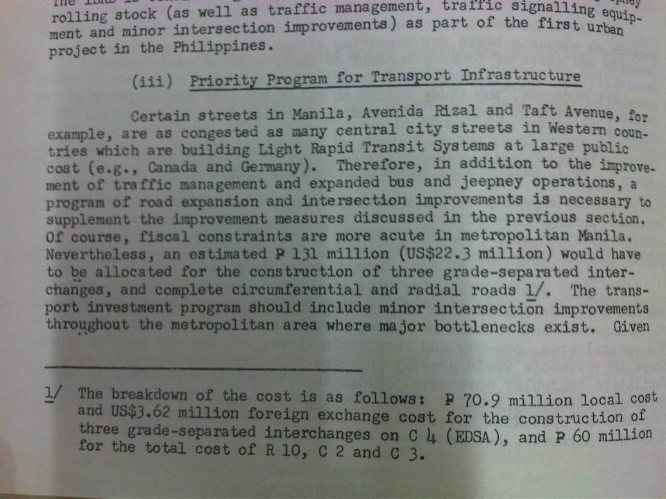
I know its been a long while since the posts on UTSMMA (1973), MMETROPLAN (1978) and other studies – past studies and plans concerning transport in Metro Manila. It seems apt that I finally was able to finish this piece in time for the Philippines Independence Day. Sinasadya talaga. I left a question hanging about what caused the changes in mindset reflected in MMETROPLAN that practically did away with the proposed mass transit network in UTSMMA. Browsing other materials at the NCTS Library, I came upon a report that I thought would have likely influenced the MMETROPLAN study team as well as government officials at the time. This is the report that I think would be the vital link between UTSMMA and MMETROPLAN – for what happened between these two studies and why the “about face” when feasibility studies were already underway for what could have been the country’s first subway line. The World Bank published a report entitled “Transport Planning in the Philippines” in 1976. The report had recommendations that were not favorable to rail transport whether for long distance or urban applications. Some excerpts are shown in the succeeding photos of pages of the document:
 Cover of the report indicating some disclaimers and restrictions to circulation. I assume that since a copy is found in a public library then it is already declassified. It is definitely a historical document and a valuable one if we are to understand transport in the Philippines and Metro Manila.
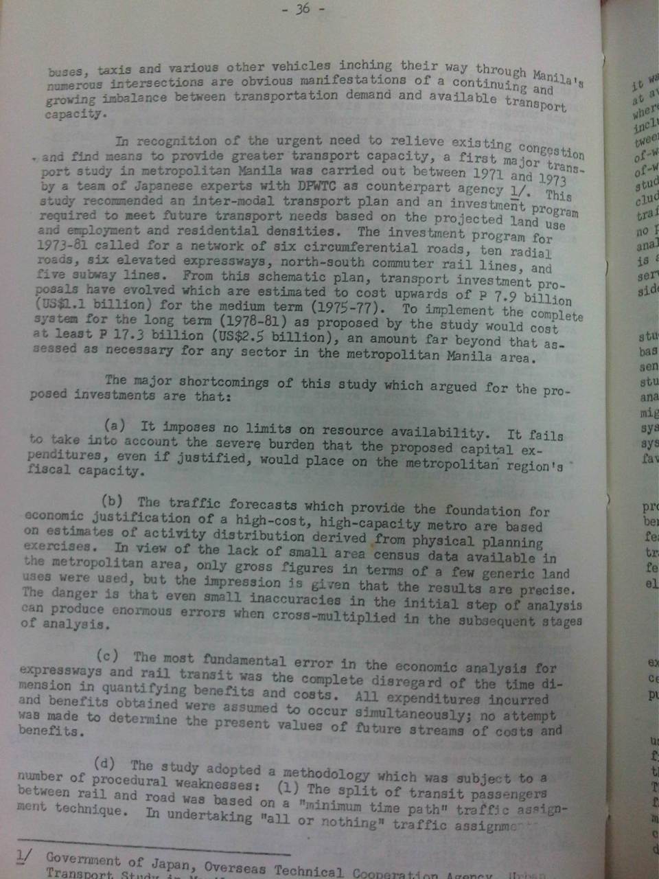 Scan of page 36 showing the WB’s assessment of UTSMMA
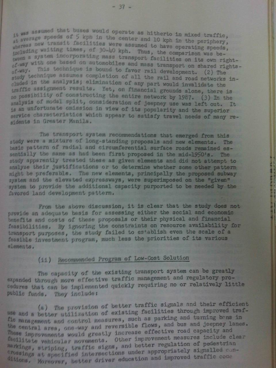 Page 37 states the conclusion of the WB report regarding UTSMMA.
I leave it up to the reader how he/she will interpret this but I think it is also important to contextualize this contents of this report to the situation of the Philippines at the time. In my opinion, too, it is basically one consultant’s word against another. From what I’ve learned, the recommended plan in UTSMMA came from a team led by a very senior and well-respected professor of the University of Tokyo’s Department of Urban Engineering. Looking back now, it seems that their work was visionary and its refuting by this WB report was a critical point in the (non)development of Metro Manila’s transport.
 A reference to LRT systems, which to some will seem like a counter-recommendation to UTSMMA
The same report suggested taking a look at LRT instead of the heavy rail recommendations of UTSMMA. This eventually led to subsequent studies seemingly having bias towards LRTs and distancing from much needed resources to improve the plight of the PNR.
 Recommendations for the long term were explicit about the importance of having a sound spatial strategy for Philippine cities.
One could only speculate what went on in the background that were off the record or not documented. Did the WB exert its influence and ‘convince’ the Philippines to shelve ambitious plans for a heavy rail network in favor of what we now know as ill-planned light rail lines? It is this same WB report that recommended for the reorganization of the then DPWTC and DPH into the DOTC and DPWH that we know today. Thus, it is not only transport policy and infrastructure influenced by this report but also institutions dealing with transport. One person’s guess is as good as another in terms of the thinking back then as there are very few people who were directly involved in planning and decision-making then who survive now and are likely willing to divulge anything that will lead us to the truth and some closure regarding what went wrong at this critical time for transport development in the Philippines.
The data and evidence points to something Marcos loyalists would cringe to admit, that the former President ultimately failed in bringing a modern public transport system to this country and its capital. [No, the LRT wasn’t as modern and progressive as they thought it to be back then. We know now that Lee Kwan Yew got it right by investing in heavy rail urban transit at that same time.] We can only speculate that perhaps the WB and those behind the scenes knew Marcos and his ilk would probably steal much of the funds that could have been allocated for the rail rapid transit system and so did their best to come up with the conclusion that it was too expensive and the Philippines couldn’t afford it. I hope my economist friends would correct me but I am leaning towards thinking that “Uutang ka na din lang, umutang ka na para sa imprastraktura na magagamit di lamang ng mga anak mo kundi pati na rin ng mga apo mo at nila.” This seems to be the basic philosophy applied by other nations that have invested much on their transportation infrastructure. Such infrastructure has already paid off many times more and are part of the backbone of strong and resilient economies.
One colleague offered the analogy that the new JICA Dream Plan for Mega Manila is actually an updated version of UTSMMA. I also believe so and it is an updated and much more validated version of what we had back in the 1970s that was at best only partly realized (the recommendations for roads were mostly implemented). However, the price for such infrastructure will not be cheap and it will only become more expensive while we procrastinate in building them. Perhaps this should be an election issue come 2016 and something that we should strongly advocate for from our leaders.
–
