
Home » Posts tagged 'UP'
Tag Archives: UP
Congested Katipunan again
During the Christmas break, we were reminded just how Katipunan Avenue can be congested due to the trips generated by the institutions along it. These are mainly the schools such as Ateneo, Miriam and UP. Based on my observations and experiences over the past decades though (I started attending UP in the late 1980s), the main culprit is Ateneo with all the private vehicles it generates for its students in all levels (Grade School, High School and College).
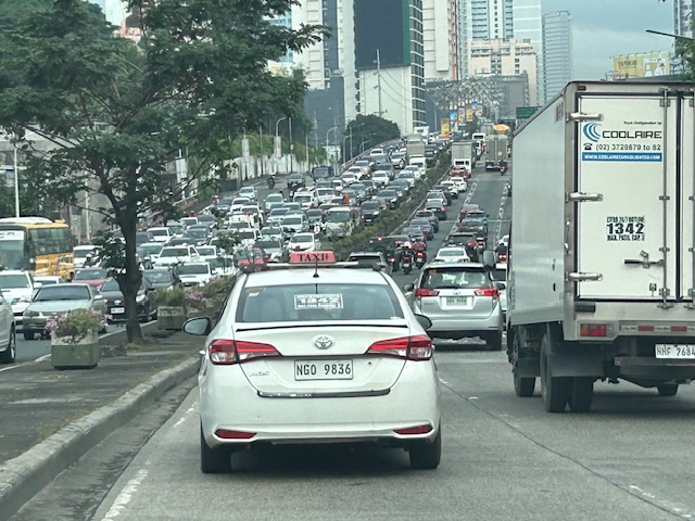 What “normal” traffic looks like on a typical weekday along Katipunan Avenue
My commute during the break is usually under 1 hour (e.g,, 40-50 minutes). But during the times when there’s school, it’s always more than an hour (e.g., 75 to 105 minutes). Will the situation improve? Will there be a mass transit system along C-5 to alleviate the traffic conditions? We can probably hope so but it doesn’t seem to be in the near horizon right now. The Metro Manila subway, after all, is expected to be operational in the 2030s!
–
The need to be alert while walking, jogging or running in campus
With the recent bad weather, I noticed a big decrease in the number of visitors to the UP Diliman campus. Most of these walk, jog or run for health or recreation. Many of these are often lost in their conversations or too focused on their activity that they become unaware of the dangers of moving under large trees whose branches might fall on them anytime. It is especially true during the wet season and when there are typhoons or storms. The water and wind often bring down the older branches and one can get serious injuries perhaps even die should a large branch fall upon them.
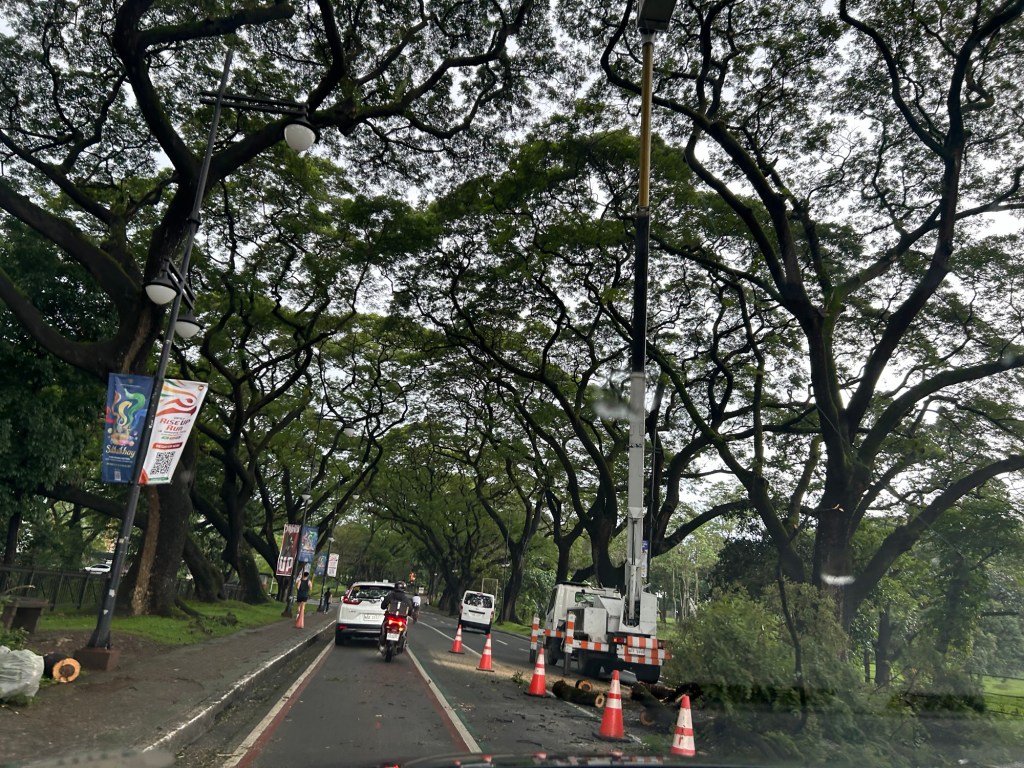
Walkers, joggers and runners (let’s also include cyclists/bikers) need to be aware of these dangers. I myself had a few near misses in the past while walking around the Academic Oval. I know people who have been injured by falling branches while they went around.
–
The need to be alert while walking, jogging or running in campus
With the recent bad weather, I noticed a big decrease in the number of visitors to the UP Diliman campus. Most of these walk, jog or run for health or recreation. Many of these are often lost in their conversations or too focused on their activity that they become unaware of the dangers of moving under large trees whose branches might fall on them anytime. It is especially true during the wet season and when there are typhoons or storms. The water and wind often bring down the older branches and one can get serious injuries perhaps even die should a large branch fall upon them.
Walkers, joggers and runners (let’s also include cyclists/bikers) need to be aware of these dangers. I myself had a few near misses in the past while walking around the Academic Oval. I know people who have been injured by falling branches while they went around.
–
UP’s University Avenue
A week ago, I was invited to witness the renewal of a Memorandum of Understanding (MOU) between UP Diliman and a leading and prominent engineering company. I think one of the highlights of that event was getting to go to the Board of Regents meeting room at the top of Quezon Hall. This used to be an open area that we went to during our college days. The only times the place was off limits was when there were important meetings at Quezon Hall (e.g,, meetings of the UP Board of Regents) and during commencement exercises. It has been transformed into an air-conditioned facility that now hosts offices and this conference room. What’s the transportation thing in this post is the magnificent view of the University Avenue, which is the main gateway to the campus.
 UP Diliman’s University Avenue as seen from the top of Quezon Hall
The University Avenue has also evolved as it now features bike lanes along each direction of the road. There are walkways that also served as bike lanes along either side of the avenue. These are visible in the photo and are protected, exclusive ROWs from the main travel lanes that used to be assigned to motorized traffic. The avenue connects UP’s Academic Oval, its campus core, to Commonwealth Avenue. I remember splendid sunsets viewed from the same vantage point as this generally faces the west.
–
A real battle of Katipunan – the search for a transportation solution
Is it obvious that I was alluding to the classic match-ups of the two major universities – Ateneo De Manila University and the University of the Philippines Diliman – that are located along Katipunan Avenue for the title of this article? That is deliberate on my part as there is a ‘real’ battle along Katipunan Avenue, and it does not involve sports.
Following is a recent article from the Philippine Collegian that reports on the current state of traffic along the corridor:
https://phkule.org/article/971/private-cars-mainly-to-blame-for-katipunan-traffic-transport-experts
I have written before and many times about transport and traffic along Katipunan Avenue. This road has been part of my daily commute since 1988 when I was admitted to UP Diliman as a B.S. Civil Engineering major. Back then Katipunan was not as wide as it is now, especially along the section between UP Diliman and the MWSS complex. That section only had 2 lanes then. What is not a wide center island with large, old acacia trees used to be the frontage of MWSS. So now you can probably imagine how much land was ceded by MWSS for road widening.
I also wanted to write about Katipunan in part as a sort of farewell to the former MMDA Chair and Marikina Mayor Bayani Fernando (BF), who recently passed away. Much of how Katipunan looks like and the traffic situation today can be traced to what transpired during his time at MMDA. I will refrain from writing about this and him for now. I am actually thinking of writing a series about BF and his time as Mayor in Marikina, as MMDA Chair, and his brief stint as DPWH Secretary. This short article will do for now.
Bike lanes at the UP Diliman campus – Part 1
I had first read about the enhanced bike lanes at the UP Diliman Academic Oval last month from a social media post of a friend. She was present as the delineations of the jogging and cycling lanes were being painted along with the baybayin marks distinguishing UP’s bike lanes from others like it. UP’s bike lanes predate the current ones around Metro Manila that mostly popped-up during the pandemic.
 The Academic Oval road original had two-way traffic along its wide carriageway, that could easily fit 4 lanes. Since it became a one-way, counterclockwise road, the lanes had been divided into 3 wide lanes with one lane initially committed to bicycles.
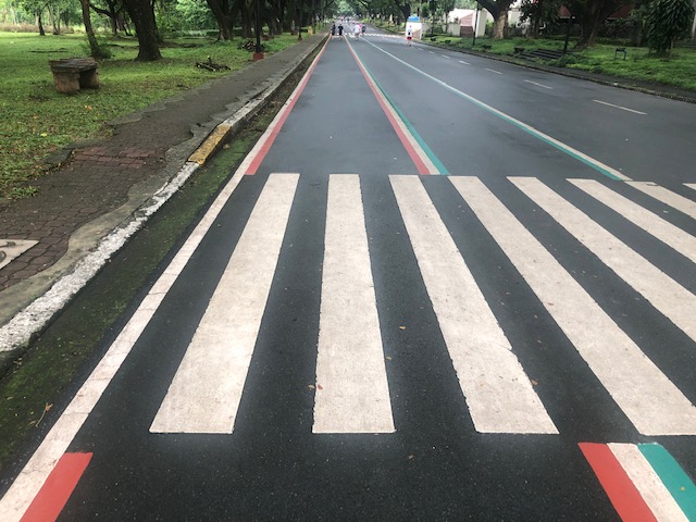 Here are the two lanes designated for joggers/walkers (curbside) and cyclists (median). The pedestrian sidewalk was originally planned to be widened in time for UP’s Centennial celebration back in 2008. That did not materialize. The Academic Oval could have had wider sidewalks for those who are not walking for exercise.
 The section in front of Melchor Hall features the words bicycles or bike lane and pedestrian in baybayin. Its certainly a novelty for now and something probably apt for the campus roads but not necessarily for others.
 A closer look at the baybayin script along the jogging/walking and bike lanes.
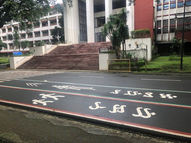 Here’s the bigger picture on the pavement markings.
 Approach to an intersection
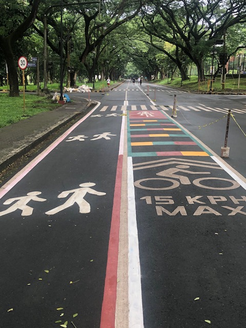 The UP colors inform riders about the intersection ahead. These are more visual as they are flat and not rumble strips. The older pavement markings advising riders of the speed limit should be seen in the context of utilitarian cycling (e.g., bike to work, bike to school) rather than cycling for fitness or recreation, which obviously may involve higher speeds and is frowned upon along the oval.
 The intersection approach from another angle.
The Academic Oval bike lane is one of the original recommendations of a transport study conducted for the campus about 17 years ago. The study was the basis for the campus being declared as a road safety zone, which among others included a provision for its roads to have a 30-kph speed limit. The one-way counter-clockwise traffic circulation and the jogging and bike lanes, however, are officially a part of what has become a long-term experiment on campus. There are many who oppose the one-way scheme and are vehement against the ultimate plan to have the Academic Oval car-free or car-less (it is mostly car-less during Sundays – part of the “experiment”).
The other new bike lanes on campus in Part 2 of this series.
–
Public Transport Recommendations of the UP COVID-19 Pandemic Response Team
Here are the recommendations of UP COVID-19 Pandemic Response Team: “Effective Reactivation of Public Transport Operations for the New Normal through an Information Exchange Platform for Collaborative Governance”


–
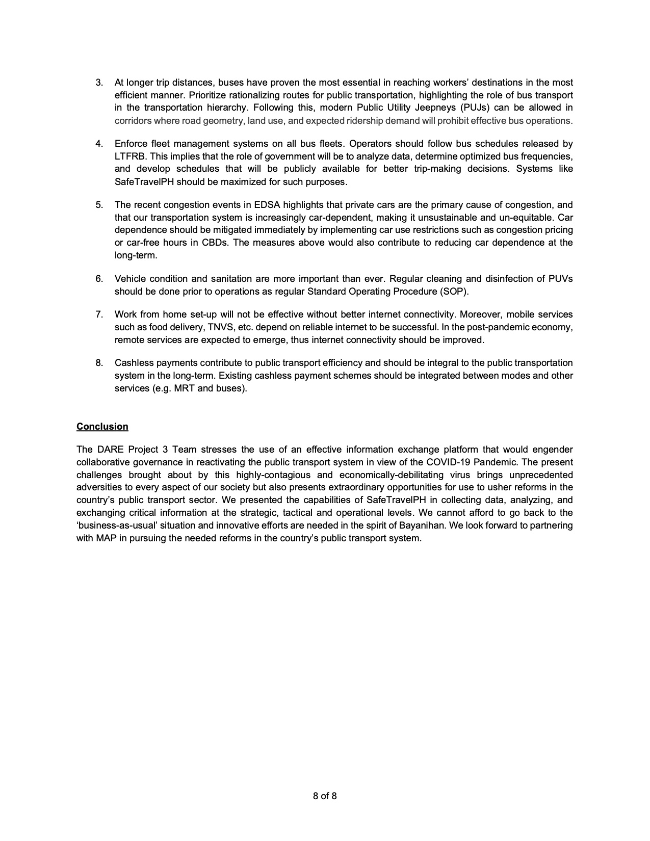
Aerial photo: Diliman, Quezon City
The aircraft we were flying on in a recent trip circled on the approach to NAIA and we were afforded some terrific opportunities to take aerial shots of Quezon City. This was before the rains of the Christmas holidays so the skies were clear of clouds. Here is one of the photos I took showing the University of the Philippines Diliman campus.
That wide road on the left is Commonwealth Avenue and you can see part of the Elliptical Road at the bottom left. There are few large patches of green in Metro Manila and many are in the largest city – Quezon City. You can see that these include the campus and Balara.
Aerial photos are no longer that rare these days as there are many who take shots from drones. Then, of course, there are shots like these you can take from the plane you’re riding. Have a nice Sunday!
–
Introducing the New Director of the National Center for Transportation Studies
The National Center for Transportation Studies (NCTS) of the University of the Philippines Diliman has a new Director. Dr Ma. Sheilah G. Napalang of the School of Urban and Regional Planning (SURP) succeeds Dr Hilario Sean O. Palmiano of the College of Engineering. Dr Napalang becomes the 5th Director of the NCTS since the latter’s transformation from the Transport Training Center (TTC) in the early 1990s, not counting the two OICs over that period.
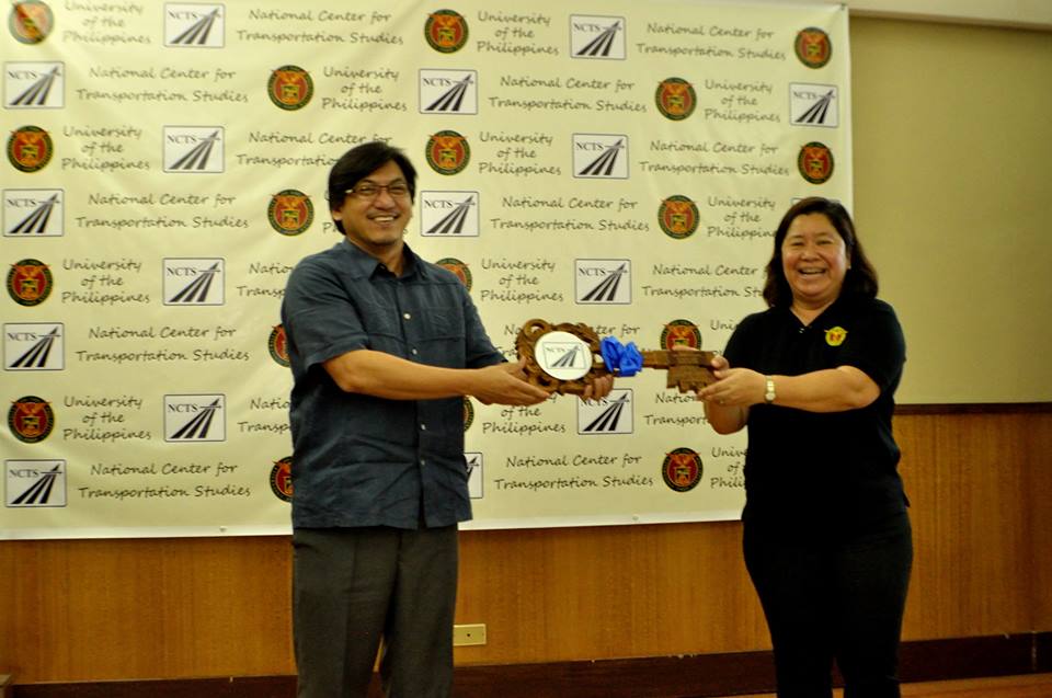 Dr. Napalang receives the symbolic key from Dr Palmiano
Dr Napalang was a former top senior technical staff of the NCTS before she joined the faculty of SURP after a short stint at the Asian Institute of Tourism (AIT) of the same university. Prior to joining UP, she was a faculty member and former Chair of the Department of Civil Engineering of Xavier University in Cagayan De Oro City in Mindanao. Dr Napalang obtained her B.S. Civil Engineering degree at Xavier University, her master’s at Virginia Tech in the US, and her doctorate at Tokyo Tech in Japan. She has done work on sustainable transport and the viability of transport systems. She has also contributed to the Cebu Bus Rapid Transit (BRT) project and the formulation of the National Environmentally Sustainable Transport (EST) Strategy. Her most recent publications are:
- Challenges of Urban Transport Development in Metro Manila: A look back at the last 40 years (lead author)
- State of Pavement Engineering in the Philippines and Implications on the Economic Life of National Roads (lead author)
These papers were presented at the recent 11th International Conference of the Eastern Asia Society for Transportation Studies (EASTS) held in Cebu City last September 2015.
Congratulations to Dr. Napalang for her new appointment, and thank you to Dr. Palmiano for his contributions as NCTS Director!
–
A new Director of the National Center for Transportation Studies
I learned a couple of days ago that there will be a new Director at the National Center for Transportation Studies (NCTS) at the University of the Philippines in Diliman soon. The new Director will be Dr. Ma. Sheilah G. Napalang who is a tenured faculty member of the university’s School of Urban and Regional Planning. She is to be the first woman head of the center, which used to be called the Transport Training Center that was created in the 1970s as part of the Japanese Government’s technical assistance to the Government of the Philippines to increase capacity and capability in transportation planning, engineering and management. Dr. Napalang will be the first Director from SURP since 2001 (since that time, all Directors were from the College of Engineering). She was a former senior technical staff of the NCTS before she joined the SURP and obtained her advanced degrees from the US (masters’ at Virginia Tech) and Japan (Dr. Eng. at Tokyo Tech).
More on this development and perhaps the turnover once everything is final and formalized.
–
