
Home » Posts tagged 'walking' (Page 4)
Tag Archives: walking
Vendors along the boulevard in Zamboanga
Our morning walks allowed us to observe some scenes in the city. Along the R.T. Lim Boulevard, there are stretches of what was probably a public beach. We saw these vendors along the shore selling shellfish and clams.
 Vendors selling shellfish – suddenly I recalled the tongue twister: “She sells sea shells by the sea shore.”
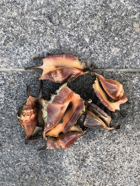 Conchs are sea snails and considered a delicacy in the Philippines
 Other sea snails that some people generally call kuhol are in buckets to keep them alive and fresh.
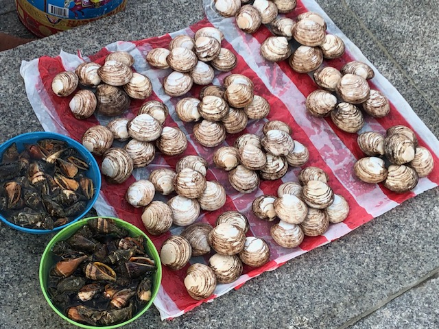 Clams make for good clear soup that will go with any viand for your meals whether it’s lunch or dinner.
These are the scenes you usually miss when you’re driving or riding. Walks or jogs bring you closer and provide the opportunity to stop and look (even inquire or take a few photos). They enhance our walks and allows a glimpse of how life was along the shores when a city like Zamboanga was not as developed as in the present. Manila used to have public beaches before the first reclamation projects eventually wiped them out. The attempt to bring those back in the form of the dolomite beaches don’t really help considering the water pollution that makes swimming or wading risky for people.
–
Morning walks in Zamboanga City – Part 2
We took early morning walks in Zamboanga City, when most people are just starting their day. That meant less people and traffic, and one can enjoy the walks without worrying about motor vehicles or crowded streets. A nice route would be from City Hall to Paseo Del Mar and First Pilar and back. This is easily 5,000 to 6,000 steps depending on the variations to the walking route.
 Zamboanga City’s Paseo Del Mar is practically deserted but for a few joggers or walkers around 6:00 AM.
 You can enjoy a walk, jog or run with views of the sea and ships
 The lamps reminded us of similar designs along Roxas Boulevard in Manila and Pasay.
 A view of the port and what used to be the Lantaka Hotel (building at right) from the Paseo Del Mar. During one of the city’s festivals, this area would be the staging ground for colorful vintas.
 This sign for the paseo would likely be a popular photo op spot.
 A potted palm tree and a bench that invites one to sit and enjoy the view
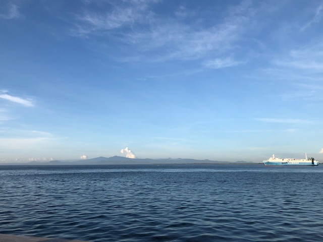 On a clear day, one can see the island of Sulu
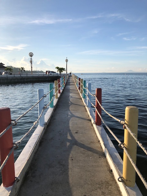 Board walk
 The space is just enough for two people going opposite directions
More photos on walking around Zamboanga City in the next posts!
–
Morning walks in Zamboanga City – Part 1
Before I return to Zamboanga City for another workshop, I wanted to at least post the first of a series about walking in the city. One advantage of staying at a hotel in downtown is that it is close to the parks and city hall. You can also walk towards Lim Boulevard or perhaps towards Fort Pilar on the opposite direction.
 Rizal Park
 Arcade style walkways integrated into the older buildings in downtown Zamboanga City
 Valderosa Street with the Zamboanga City Hall on the right

 Rizal Park viewed from City Hall
 A close up of the Rizal monument
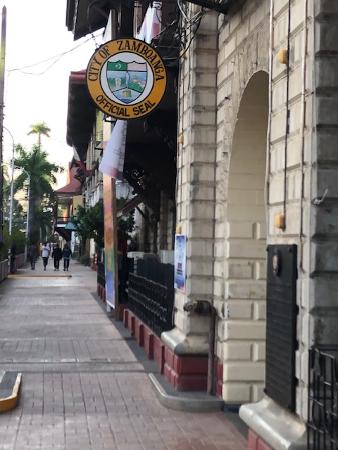 One of the entrances to city hall has the official seal of the city on display.
 Historical market for the building, which was first constructed during the American Period. It states that the building also used to be the Provincial Capitol. It is a heritage structure that is over a century old.
 The sidewalks are wide and paved. Planters are located along the curb to enhance the environment.
 Historical marker on an old house that was the official residence of Gen. John Pershing (yes, that Pershing) and which became BPI’s first branch in the city.
 Other old houses may be found along Valderosa Street. Many if not most are in a state of disrepair.
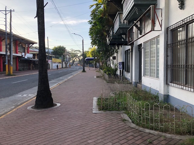 Sidewalk fronting what used to be the Lantaka Hotel. Part of the hotel is now with Ateneo de Zamboanga.
 Graffiti on the walls along Valderosa Street
 Section fronting what used to be the Lantana Hotel. It is now part of Ateneo de Zamboanga.
More photos in Part 2, which is coming out soon!
–
Article share: on pedestrian facilities and climate change
Here is an article that articulates the importance of walking and pedestrian facilities in sustainability and ultimately fighting climate change. It argues that if we had the infrastructure and facilities to make it easier for people to walk, they will and are likely to walk rather than use their cars. This is not limited to short trips as walking can be in combination with public transportation, making it an integral part of trips where public transportation covers the main commute and walking is the proverbial last mile travel.
To quote from the article:
“Walking, biking, and transit need to be prioritized, and treated as legitimate forms of transportation. This means stepping up efforts to collect data on sidewalks the way we do for roads, investing in complete walking networks before engaging in expensive new road projects and making sidewalk construction and maintenance a municipal responsibility rather than an individual one.”
Another definition of the 15-minute city
We begin 2023 with an informative article defining the “15-minute city”. This is actually an entry in Planetizen’s Planopedia, which contains definitions of fundamental concepts in urban planning:
Ionescu, D. (December 2022) “What is a 15-minute City?” Planetizen, https://www.planetizen.com/definition/15-minute-city?utm_source=newswire&utm_medium=email&utm_campaign=news-12292022&mc_cid=ee083e2ee7&mc_eid=9ccfe464b1 [Last accessed: 1/1/2023]
I’ve written and shared articles about this concept before. Here are a couple from 2021 where I offered my opinions about the concept as already applied in the Philippines:
https://d0ctrine.com/2021/08/13/on-defining-the-15-minute-city/
https://d0ctrine.com/2021/04/07/didnt-we-already-have-15-minute-cities-and-towns-in-the-philippines/
–
Examples of legislative actions in support of active transport
While the Philippine government and various local government units seem to be reneging on their commitments to support active transport, other countries have been building on their gains during the pandemic. Here are examples of legislations in New York State that will support active transport through funding of complete streets projects and institutional arrangements for representation of transit dependent individual:
The article is about two legislations:
Legislation (S.3897/A.8936-A) Provides Funding for “Complete Streets” Projects Inclusive of a Holistic Approach to Street Design
Legislation (S.3959-B/A.7822-C) Adds Board Seats to NFTA, RGRTA, CDTA, and Central New York Regional Airport Authority Dedicated to a Transit Dependent Individual
We hope to see something like these at least at the local level. Perhaps if LGUs are able to legislate and implement these, there will be more good practice examples that will compel national government to support active transport development. The latter is actually ironic considering that many plans are supposed to spell out the national government’s commitment to active transport. There are still live memorandum orders and department orders supporting and promoting active transport. Are these also being waylaid? That will be tragic for transportation if we didn’t learn or gain anything from the experiences during this pandemic.
–
Shared article: Active and Micro Mobility Modes Can Provide Cost-Effective Emission Reductions–If We Let Them
I’m sharing this article on active and micro mobility modes from Todd Litman, published in Planetizen.com:
Source: Active and Micro Mobility Modes Can Provide Cost-Effective Emission Reductions–If We Let Them
From the article:
“Common Active Transportation Leverage Effects:
–Shorter trips. Shorter active trips often substitutes for longer motorized trips, such as when people choose a local store rather than driving to more distant shops.
–Reduced chauffeuring. Better walking and bicycling conditions reduces the need to chauffeur non-drivers (special trips to transport a passenger). These often require empty backhauls (miles driven with no passenger). As a result, each mile of avoided chauffeuring often reduces two vehicle-miles.
-Increased public transit travel. Since most transit trips include walking and bicycling links, improving these modes supports public transit travel and transit-oriented development.
-Vehicle ownership reductions. Active mode improvements allow some households to reduce their vehicle ownership, which reduces vehicle trip generation, and therefore total vehicle-miles.
-Lower traffic speeds. Active travel improvements often involve traffic speed reductions. This makes non-auto travel more time-competitive with driving and reduces total automobile travel.
-More compact development. Walking and bicycling support more compact, multimodal communities by reducing the amount of land devoted to roadways and parking, and creating more attractive streets.
-Social norms. As active travel increases, these modes become more socially acceptable.
The article is a must read if we are to understand how important active transport and micro mobilities are in the context of today’s transport conundrum. Of course, part of the contextualization and perhaps ‘localization’ on these modes will be related to land use or development. The latter is a big challenge especially for the likes of Metro Manila and other rapidly developing cities in the Philippines where housing in the cities (related to compact development) has become quite expensive and has driven more and more people to live in the suburbs. As I’ve mentioned in previous posts, this has resulted in more pressure to develop transportation systems but infrastructure development cannot play the catch up game given the limited resources for their construction. Meanwhile, services are also behind in terms of quality and requires reforms and rationalizations.
–
On having daily walks to improve health and wellness
We begin October with an article about walking, health and wellness. I can relate to this article as we take daily walks, usually in the mornings. One positive outcome of the COVID-19 pandemic and the shift to more hours from home (rather than at the workplace) is that we have been able to schedule and increase time for our walks. And this has led to a healthier lifestyle for us.
To quote from the article:
“When it comes to brisk walking, “at these moderate levels of effort, you are able to increase your aerobic capacity,” Dr. Singh said. In addition to the long-term health benefits, such intensity would also lower blood pressure, moderate blood sugar levels and lower the risk for heart attacks and strokes.
The key is to walk at an intensity that is manageable but also slightly pushes the boundaries of what is a comfortable pace.
“That constant slow stress on your body is what leads to fitness gains,” Dr. Singh said. “If you’re just getting started, this is probably the easiest way to get started and stay committed, consistent and injury-free.””
On the benefits of developing and investing in active and public transportation
Here is another quick share of an article with a very relevant and timely topic – the business case for multimodal transport planning:
Litman, T. (July 2022) “The Business Case for Multimodal Transportation Planning,” Planetizen, https://www.planetizen.com/blogs/117697-business-case-multimodal-transportation-planning?utm_source=newswire&utm_medium=email&utm_campaign=news-07142022&mc_cid=03c159ebcf&mc_eid=9ccfe464b1 [Last accessed: 7/15/2022]
To quote from the article:
“Conventional planning tends to undervalue non-auto mode improvements by assuming that each additional mile of their travel can reduce, at best, one vehicle mile traveled. In fact, in many situations they can leverage much larger reductions in vehicle travel, meaning that each additional mile of walking, bicycling, or public transit can reduce more than one vehicle mile … As a result, walking, bicycling and public transit improvements can provide much larger vehicle travel reductions and benefits than is commonly recognized.”
There is a box referred to in the preceding quote. I will not reproduce it here so I leave it up to the reader to go to the original article by Litman to find out how active and public transport can leverage additional travel reductions. Understanding these and the extend by which we can be independent of car-use (referring to non-car travel demand) will allow for a better appreciation, travel-wise and economics or business-wise, of the advantages of developing and investing in active and public transportation infrastructure and services.
–
Bike lanes at the UP Diliman campus – Part 1
I had first read about the enhanced bike lanes at the UP Diliman Academic Oval last month from a social media post of a friend. She was present as the delineations of the jogging and cycling lanes were being painted along with the baybayin marks distinguishing UP’s bike lanes from others like it. UP’s bike lanes predate the current ones around Metro Manila that mostly popped-up during the pandemic.
 The Academic Oval road original had two-way traffic along its wide carriageway, that could easily fit 4 lanes. Since it became a one-way, counterclockwise road, the lanes had been divided into 3 wide lanes with one lane initially committed to bicycles.
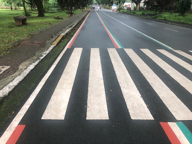 Here are the two lanes designated for joggers/walkers (curbside) and cyclists (median). The pedestrian sidewalk was originally planned to be widened in time for UP’s Centennial celebration back in 2008. That did not materialize. The Academic Oval could have had wider sidewalks for those who are not walking for exercise.
 The section in front of Melchor Hall features the words bicycles or bike lane and pedestrian in baybayin. Its certainly a novelty for now and something probably apt for the campus roads but not necessarily for others.
 A closer look at the baybayin script along the jogging/walking and bike lanes.
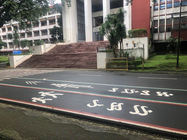 Here’s the bigger picture on the pavement markings.
 Approach to an intersection
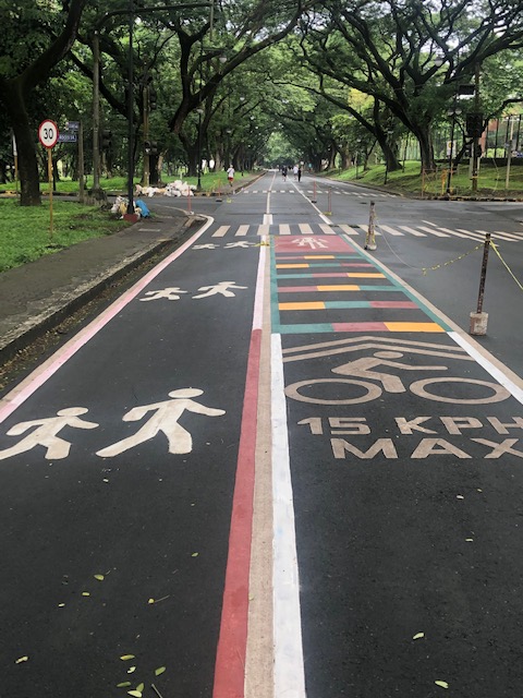 The UP colors inform riders about the intersection ahead. These are more visual as they are flat and not rumble strips. The older pavement markings advising riders of the speed limit should be seen in the context of utilitarian cycling (e.g., bike to work, bike to school) rather than cycling for fitness or recreation, which obviously may involve higher speeds and is frowned upon along the oval.
 The intersection approach from another angle.
The Academic Oval bike lane is one of the original recommendations of a transport study conducted for the campus about 17 years ago. The study was the basis for the campus being declared as a road safety zone, which among others included a provision for its roads to have a 30-kph speed limit. The one-way counter-clockwise traffic circulation and the jogging and bike lanes, however, are officially a part of what has become a long-term experiment on campus. There are many who oppose the one-way scheme and are vehement against the ultimate plan to have the Academic Oval car-free or car-less (it is mostly car-less during Sundays – part of the “experiment”).
The other new bike lanes on campus in Part 2 of this series.
–

