
School is back and so are safety issues for schoolchildren
It’s school time once again in most parts of the Philippines. Public and private schools including most colleges and universities have resumed classes this month of June while others start this July and August. But with the resumption of classes, there is also the re-emergence of issues pertaining to the safety of these children. Students are exposed to the hazards of commuting. These include the likelihood of being injured or killed by vehicles running along the roads the students use to get to school.
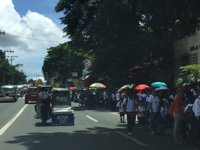
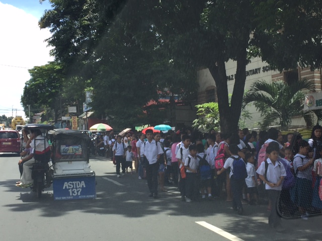 The photo above is a typical scene in front and around many public schools in the country. Schools are located along national roads and often lack spaces for students and their guardians. Many end up occupying the roads and causing congestion. Of course, that congestion is secondary to the safety of these children. Nevertheless, such issues need to be addressed in a more holistic manner rather than attempt to solve one as if they could be isolated.
 Most students of grade schools and high schools around the country either walk or take public transportation in their commutes. They are exposed almost daily to motor vehicle traffic along the roads and risk being sideswiped or run over by vehicles. In certain cases, small children walk significant distances thereby increasing the likelihood and risk of being harmed by traffic.
Traffic is particularly bad along most roads leading to schools mainly during the morning, mid-day and afternoon periods when students arrive or leave their schools. In Metro Manila, for example, the worst congestion are experienced along major roads like Katipunan Avenue (due to traffic generated by Ateneo, Miriam and UP) and Ortigas Avenue (due to La Salle Greenhills). That means a lot of time and fuel are wasted and more emissions are released into the air that we breathe. However, one can argue that in terms of road safety, this is better since gridlocks mean slow moving vehicles that make it safer for walking or cycling. This is not the same in the provinces or rural areas where there is less congestion and vehicles travel at faster speeds.
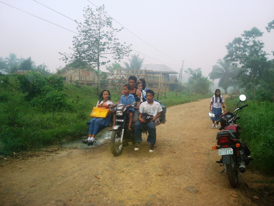 Children heading to school on a ‘skylab’ version of the motorcycle taxi
While there are initiatives pertaining to revisions in speed limits, such are limited (pun not intended) by how much action can be done in order to enforce these regulations. Add to this the requirement of having the instruments to measure and record speeds in aid of enforcement. This was what MMDA did along Commonwealth Ave. and Macapagal Blvd. with the acquisition of two speed guns. I don’t see them using these anymore and wonder if the instruments are still working. Meanwhile, expressway authorities are using these as they continue their enforcement of speed limits along tollways. [I am aware of NLEX and SCTEX enforcement units employing speed guns along those tollways.]
The DPWH is also doing its part by doing road safety audits and identifying measures to reduce the likelihood of crashes involving these students. Among these are rumbles strips and, in some cases, the construction of sidewalks but these are not enough. There were recommendations from an iRAP project many years ago but the agency was resistant to what they thought were new and innovative ideas that were actually already being implemented in other countries. Perhaps these recommendations and that iRAP study could be revisited and solutions drawn from there?
–
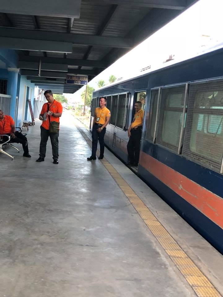
PNR Calamba Station
The last set of photos on PNR stations that I have and want to share to my readers is this set on the PNR Calamba Station.
 Train loading passengers before proceeding – there are few trains and headways are long so it takes a while waiting for the train to go
 DOST-MIRDC’s hybrid electric train – is it undergoing maintenance or has it reached the proverbial “end of the line”?
 Head of the train
 Interior of the commuter train
 Sign verifying which station this is
 Station platform
 PNR staff having a time-out between train operations
–
A compilation of studies on walkability in the Philippines
My students have been engaged in studies on walkability (and related topics) the past few years. These have been a mix of published and unpublished work that I have compiled at list below:
Unpublished works:
- Capalar, M.A.M. and Garma, F.A.A. (2018) Assessment of Walkability Along Taft Avenue, Unpublished Research Report, Institute of Civil Engineering, University of the Philippines, Diliman
- Pajarin, J.B., Soriano, C.M. and Regidor, J.R.F. (2017) Assessment of Mobility of Persons with Disabilities (PWDs) in Cainta, Rizal, Unpublished Research Report, Institute of Civil Engineering, University of the Philippines, Diliman.
- Cortez, E.H.D. and Razon, J.V.DV. (2017) Assessment of Walkability Along Katipunan Avenue, Unpublished Research Report, Institute of Civil Engineering, University of the Philippines, Diliman.
- Marcelo, K.R.S. and Salvador, J.P.B. (2015) Assessment of Pedestrian Facilities Along Marcos Highway, Unpublished Research Report, Institute of Civil Engineering, University of the Philippines, Diliman.
Published works:
• Pajarin, J.B., Soriano, C.M. and Regidor, J.R.F. (2018) “Assessment of Mobility of Persons with Disabilities (PWDs) in Cainta, Rizal,” Philippines Transportation Journal, Vol. 1, No. 1, pp. 60-80.
• Pajarin, J.B., Soriano, C.M. and Regidor, J.R.F. (2017) “Assessment of Mobility of Persons with Disabilities (PWDs) in Cainta, Rizal,” Proceedings of the 24th Annual Conference of the Transportation Science Society of the Philippines, Quezon City, July 21, 2017.
• Regidor, J.R.F., Marcelo, K.R.S. and Salvador, J.P.B. (2016) “Assessment of Pedestrian Facilities Along Marcos Highway,” Proceedings of the DPWH Research Symposium 2016, Quezon City, September 2016.
Here’s a paper based on a comprehensive study our centre conducted for the City of Olongapo in the Province of Zambales:
• Palmiano, H.S.O., Javier, S.F.D. and Regidor, J.R.F. (2015) “An Assessment of Walkability in a Medium-Sized Philippine City,” Proceedings of the Eastern Asia Society for Transportation Studies, Vol. 10, December 2015.
We hope to continue such studies with future advisees who perhaps can tackle other corridors or even areas. Among those on my Wishlist would be Espana Avenue, Ortigas Avenue, Intramuros, Recto Avenue, and even EDSA or Circumferential Road 5.
–
Park and ride near the Line 2 Santolan Station?
These days when there are heavy rains and the threat of flooding, the Marikina river and its riverbanks come to mind. In the Santolan area, where a former Mayor of Marikina has invested a lot in developing a bus terminal, he seems to be stretching it in terms of trying to make the area a major intermodal terminal and maximising utility of the land. The latest venture is described by the sign below:
 “Park and ride” sign along the Marcos Highway Bridge crossing the Marikina River
A closer look at the sign shows what’s written at the lower part. That is, that the parking spaces are “walking distance” from the Line 2 Santolan Station. I’m not sure if they measured the actual walking distance and what it would take to walk that distance between this parking area for the “park and ride” and the Line 2 Santolan Station. A quick measurement using Google Maps indicate that the distance between these two are more than 400m, and this is not an ‘easy’ walk considering that you would have to ascend from or descend to the riverbanks level and there is no shelter from the elements for what would be regular walks if one is to commit to this “park and ride” arrangement. If I were to walk such a distance, then I would likely choose to park at the mall and use the long footbridge connecting it to the station.
I still maintain that the best location for a “park and ride” would be one near the station similar to the Trinoma mall parking lot being practically adjacent to the Line 3 North EDSA station. And that is what LGUs, the railway authorities or the private sector should look into for projects like the Line 2 Extension and Line 7. The area around the future Line 2 Masinag Station presents a lot of possibilities in terms of parking facilities including perhaps a redevelopment of the existing SM City Masinag to be integrated with the station. As for Line 7, the areas around another SM City (Fairview) also presents opportunities for “park and ride” facilities.
–
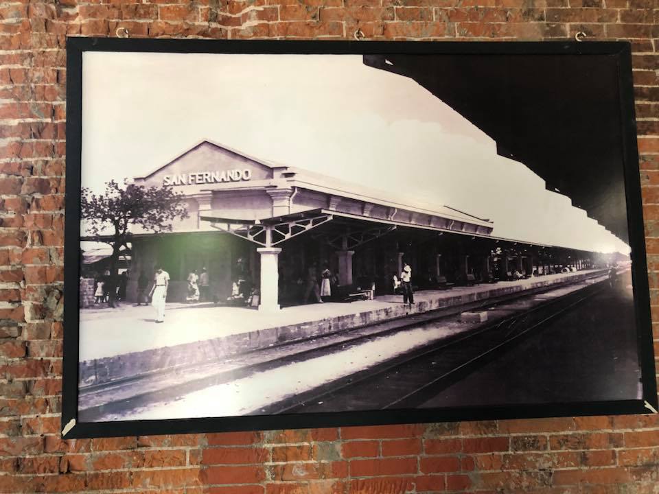
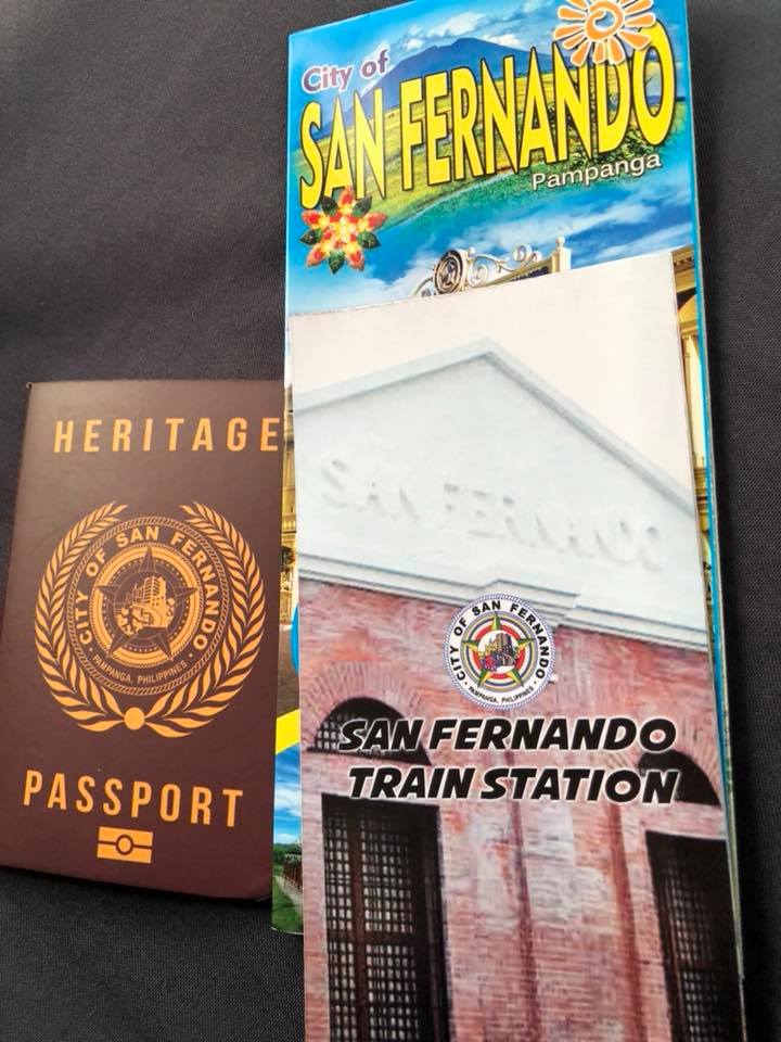
PNR San Fernando, Pampanga
It’s Araw ng Kalayaan (Independence Day) in the Philippines so I thought it was appropriate to feature something related to Philippine history and heritage. Railways in the Philippines played a part in its history being a mode of transport that connected the provinces of major islands like Luzon and Panay. The other railways were more for freight (e.g., agricultural goods) rather than for passengers so the railways in Luzon and Panay, especially the former, had more impact on socio-political events including the wars of independence from Spain and later, the United States. One station that probably figured in the actions during those times more than a 120 years ago is the PNR Station in San Fernando, Pampanga, which was along the main line north that was used by Philippine revolutionaries to transport troops and logistics.
Following are photos of the station, which has been converted into a museum. The proposed revival of this northern rail line will mean that a new station will have to be constructed but it would be good to integrate the old one with the new. Those responsible should work towards heritage preservation in this and other cases of railway stations.


–
On Quezon City’s Kalayaan Avenue bike lanes
Another example of what can be called “pwede na iyan” bike lanes are those found along Kalayaan Avenue in Quezon City. To be fair, the city made an effort to paint the bicycle lane and put up signs for this. However, one will observe that there is poor enforcement in relation to the bike lane as you would find vehicles parked on the lane. There is also the question of bicycle traffic as there doesn’t seem to be many cyclists along Kalayaan, making the space fair game for other vehicles including tricycles and motorcycles. Then there is the matter of connectivity. The Kalayaan bike lane seems to be isolated and does not have a connection to any other bike lane. The lane around the Elliptical Road, for example, is in the inner side of that road. Teacher’s Village does not have bicycle lanes but perhaps it is not (yet) necessary to have exclusive lanes in the still predominantly residential area (note: commercial establishments are still on the rise along major roads in the village).
 Vehicles parked on the Kalayaan Avenue bike lane
 Free flowing traffic along Kalayaan – notice the vehicles parked on the sidewalk?
One big question comes to mind with regards to such bike lanes: How do we improve the situation in order to encourage more people to bike? There are many answers to this question and the answers branch out to the infrastructure, policy, social and even societal, and other aspects concerning cycling. What we should bear in mind and what Quezon City and perhaps MMDA should work on is a strategy for promoting non-motorised transport (NMT) that includes walking and cycling that can be implemented metro-wide with safety and efficiency (incl. connectivity) as the main objectives rather than have piecemeal projects for show or demonstration.
–
On illegal parking
The following photo pretty much sums up the topic for this post:
 How many violations do you see here? The driver of the dark coloured vehicle had three outstanding violations – parking on the pedestrian crosswalk, blocking a fire hydrant, and blocking a PWD ramp.
The penalty for such violations as shown above used to be a paltry 500 pesos. However, a third violation will lead to a suspension of revocation of the driver’s license of the offender. That is, if authorities such as the Land Transportation Office (LTO) are able to track these violations. The fines have been updated recently to 1,000 pesos. Illegal on-street parking is perhaps among the most frequently committed violations that usually contributes to traffic congestion as it occupies space and reduces road capacities. It also blocks the typical paths of cyclists. A variation of on-street parking where parts of the vehicles are on the sidewalk is also problematic as it deprives pedestrians walking space and may lead to road safety issues especially if pedestrians are forced to use the road.
How do we address such issues? These are matters that can easily be addressed by enforcement. Yes, the catch all for many of our transport and traffic ills happens to be enforcement or rather the lack of it in many instances such as what’s shown in the photo above. This is an enduring and perhaps festering issue among those tasked with enforcing traffic rules and regulations. And we can only hope that they are up to the challenge.
[Note: The photo above was taken in the University of the Philippines Diliman campus along the Academic Oval and just after the intersection with Apacible Street. UP people like to say that what happens on campus is a microcosm of society. I cannot but agree in the case of the situation shown.)
–
PNR EDSA Station
Another station where our staff conducted surveys at is the PNR EDSA Station. This is the one close to the Magallanes interchange where you can get off if you’re transferring to a bus or jeepney using EDSA, South Super Highway or Chino Roces. Here are some photos taken a few weeks ago.
 Station platform with a commuter train in the background. Note the lack of signs and the condition of the railway tracks.
 PNR commuter train – it is noticeable that the train is much shorter compared to the platform. The same platforms served the longer trains serving provincial routes back in the day.
 Arriving train beneath the overpass that’s part of the Magallanes interchange (intersection of EDSA and SLEX)
 Another photo of the station with a train stopped to unload and load passengers – the service frequency, I’ve been told, is still quite low. The PNR services have a lot of room for improvement but they will have to acquire more rolling stock and rehabilitate their tracks. Perhaps they should also improve their fare collection system (Beep card?)?
–
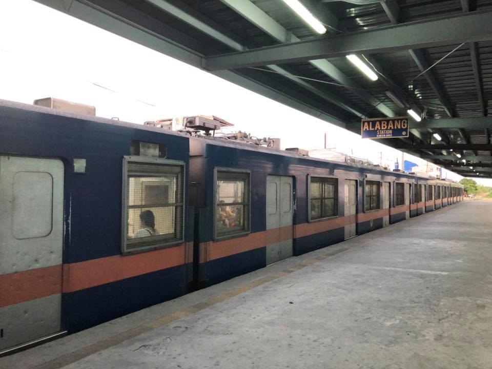
PNR Alabang Station
My colleagues conducted a survey at several Philippine National Railway (PNR) stations in relation to studies being made for proposed new railway lines including those for rehabilitation. One was already posting photos on her social media account so I asked if I can use some of her photos here on this blog. She generously obliged so here are photos taken just a few weeks ago at the PNR Alabang Station.
 PNR commuter train at the Alabang Station – note the conditions of the railway tracks and how open the station is.
 People (not necessarily passengers) walk along the railway tracks
 Passengers queued to get tickets for their journey
 Station platform
 Another photo of the platform and train
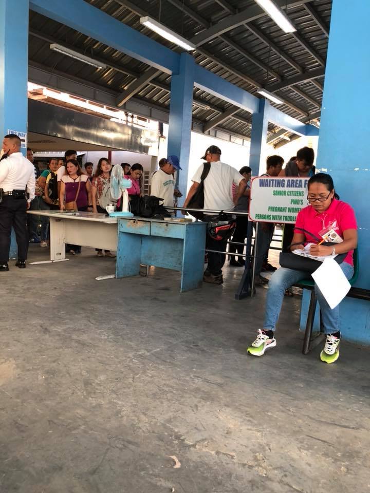 Passengers queued for tickets and entering the platform (yes, no turnstiles here) while a surveyor works
 Here’s a train that’s about to close its doors after loading passengers
More photos soon!
–
On the old overnight parking rates at NAIA
I found a couple of old parking tickets from the Ninoy Aquino International Airport. Both are for overnight parking, which shows how cheaper overnight rates were before. The amounts to be paid then were also simpler to calculate since an overnight is automatically computed as either 40 or 300 pesos. Note that the 40-peso overnight fee was for the open parking lots of NAIA T2 and T3. The 300-peso fee was for the multi-level building of T3. I’ll just put these photos here for reference and those throwback moments.

–
