
Home » Highways and Streets (Page 11)
Category Archives: Highways and Streets
On making roads safer for students
Here is a nice article from the National Academies of Science, Engineering and Medicine about how transportation research makes roads safer for students as they go back to school:
Transportation research makes the road safer for students to get back to school
There is a wealth of information there, and one should browse and perhaps download resources shared that can be useful references not just for those in North America but elsewhere towards making journeys between homes and schools.
 Scene near a public school in Zamboanga City [photo taken in June 2019]
We, too, have several initiatives towards making the journeys of children safer between their homes and schools. It is something that all of us find essential and worthwhile. Children, after all, represent our future and making their journeys safer gives them better chances to succeed in life. It also shows them examples that they can replicate for their own future children. I will write more about these as we obtain the data and perform our assessment.
–
On designing street for bicycles
There have been a lot of discussion both online and offline about coming up with bike lanes for Metro Manila. Already, there are examples of pop-up bike lanes in some cities while others have had bike lanes and bikeways constructed years ago (e.g., Marikina and Iloilo). While agencies like the DPWH and MMDA have formed technical working groups (TWG) for bike facilities, the perception is that these are moving too slowly (dragging?) and have not produced any gains in so far as design recommendations or guidelines are concerned. Just how important are such guidelines and perhaps at the beginning, context setting, to come up with suitable designs incorporating cycling (and walking) rather than the usual car-centric set-ups? Here’s another article I am sharing that argues for these street designs:
Jaffe, E. (2020) “The most important bike technology is…street design”, medium.com, https://medium.com/sidewalk-talk/the-most-important-bike-technology-is-street-design-401c94065b5c [Last accessed: 7/26/2020]
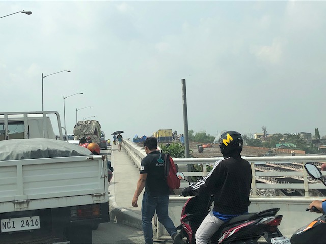
 People biking to work along the Marcos Highway bridge’s painted bike lane
–
Scenic highways? On the irony of “Daang Kalikasan”
There’s a lot of buzz about new roads nearing completion in the provinces of Pangasinan and Zambales. What is touted as scenic highways became an instant hit and attracted a lot of visitors who apparently wasted little time in trashing the area. The recent news now state that the road has been closed due to the garbage and some road crashes attributed to the influx of tourists in the area:
Mountain roads linking Pangasinan, Zambales closed over accidents, trash
There were a lot of posts that appeared on my social media newsfeed about these roads and the scenery around them. While I have seen a lot of roads with splendid or even magnificent sceneries whenever I go on road trips, the first thing that came to my mind was a question whether the landscape was like that before. I suspected that there used to be forests on these mountains and that the trees were irresponsibly cut down (some people will use the word ‘harvested’ as if they grew and cared for the trees) and never replaced. Some friends from Zambales say there used to be trees there and another recalled old dirt roads in the areas used for logging. So it’s ironic that the road is named “Daang Kailkasan” when nature was practically raped by people who ravaged the land many years ago. Indigenous people who we often refer to as “katutubo” also would likely have never consumed more than what they needed. Scenic? Maybe ‘depressing’ is a more suitable term for these roads.
–
On pedestrian crossings: innovating on the pavement markings?
I recently saw what looks like a project of the City of Antipolo where several pedestrian crosswalks are being painted over with artwork including a basic road safety message. The photo below shows one in progress across from the Provincial Capitol (aka Ynares) along the Antipolo City Circumferential Road.
 Photo of artwork in progress to cover the existing pedestrian crossing (zebra) pavement markings at the Rizal Provincial Capitol
Recently, I’ve seen news reports and posts by the proponents being shared in social media about the project. From what I’ve learned from reliable sources within the Department of Public Works and Highways (DPWH), this is an initiative with the blessing of the city and did not go through the DPWH. The main concern here is whether this ‘innovation’ of sorts will be effective and if the artist(s) behind the project used the proper materials (i.e., paint for pavement markings that are supposed to be highly visible day or night) for this project. If not, then this is just street art similar to what artists did on the UP Academic Oval a few years ago in front of Palma Hall. Sorry to blow your bubble but its more a publicity stunt than a safety device if proponents do not use the proper materials. I hesitate to use the term ‘design standards’ here because this is supposed to be artwork and perhaps the word ‘standard’ doesn’t apply. But to claim this enhances safety is at this point a stretch.
More first-hand photos soon…
–
Highway 2000, Taytay, Rizal
Prior to taking the photos I posted on Barkadahan Bridge, I was able to take a few photos of Highway 2000.
 Section right after the Taytay Public Market – it is basically a 4-lane road but there are no lane markings for either direction. There is only the double line indicating which sides are for opposing flows of traffic.
 Informal shops along the highway
 There are many garments and textile factories and depots/warehouses along Highway 2000 and from their names appear to be Chinese-Filipino or Chinese-owned businesses.
 There are also several gas stations along the highway including this Shell station that used to have cheaper fuel prices than others like it in Taytay and Antipolo.
 Bikers along the highway – new pavement markings should include those for bike lanes on either side of the highway. Ideally, bike lanes or bikeways should be protected and consistent with the design along C-6.
 There seems to still be a lot of informal settlers along this road as evidenced by shanties on either side of the highway.
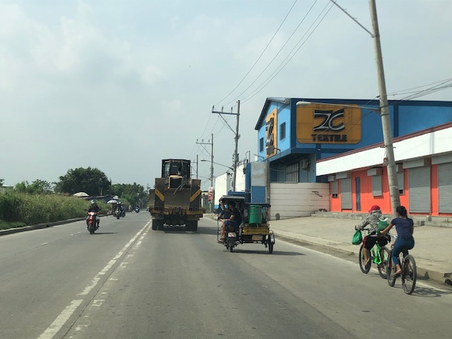
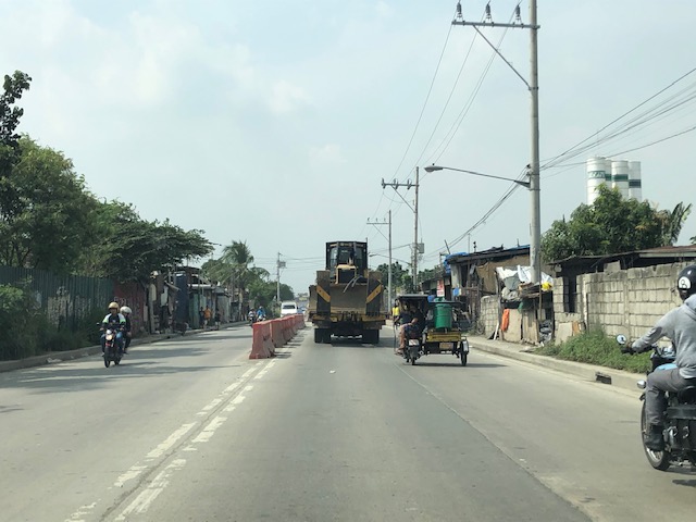
 There are many trucks using Highway 2000. Among them are those carrying tractors or heavy equipment like the one shown here hauling a bulldozer.
 Orange barriers delineate opposing traffic at the Highway 2000 approach to Barkadahan Bridge. The intersection before the bridge is with the East Bank Road of the Manggahan Floodway.
I posted the following photo earlier. This show the RROW acquired along the eastbound side of Highway 2000.

Highway 2000 already figures as a major link between Rizal and Metro Manila. It is part of an alternate route between Rizal and major CBDs like BGC and Makati via Circumferential Road 6. It is also a route to the south via Bicutan and eventually SLEX. Thus, it is imperative that this corridor and the Barkadahan Bridge be improved in order to carry the potential traffic (both non-motorized and motorized) that it is supposed to. Highway 2000 in particular should already feature protected bike lanes consistent with the design along C-6 in order for it to be transformed into part of a “bicycle highway” that can be the backbone for cycling as a mode for commuting.
–
Traffic congestion due to Barkadahan Bridge rehab
Here are more photos of the situation in the vicinity of Barkadahan Bridge. Photos were taken on a late Sunday morning (around 11 AM). Photos show the traffic congestion particularly along the eastbound side of Ejercito Avenue and Barkadahan Bridge.
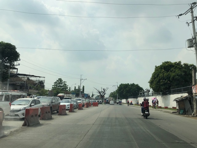 Even before completely crossing the bridge, one can see how long the queue from C-6 is. This is a photo of the queue just past the West Bank Road. The road here is names Ejercito Avenue after former Pres. Joseph Estrada whose real family name is Ejercito.
 Truck occupying an entire lane and encroaching on one of the lanes to C-6. This is due to the bottleneck caused by the wall of a residential subdivision across from the Greenwoods gate. The wall actually only contains the subdivision name and yet DPWH has been unable to expropriate the land that includes part of that subdivision’s driveway.
 Long queue extending towards Tapayan Bridge along Ejercito Avenue
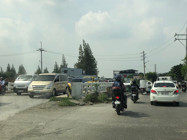 Queue along Tapayan Bridge or bridges considering there are two – one for each direction of traffic.
 Queue crossing the bridge and the bend towards C-6 and Lupang Arenda, which is a major relocation site for Metro Manila squatters during the time of then Pres. Joseph Estrada. Vehicles turn left towards C-6 while those going straight continue along Ejercito Avenue towards Pinagbuhatan, Pasig City.
 The queue reaches C-6 on a Sunday morning. It is likely worse on weekdays.
–
Status of Barkadahan Bridge, Taytay, Rizal
I recently wrote about the Barkadahan Bridge and its current state and compared it to the Marcos Highway Bridge that is now completed and fully opened to travelers. Unfortunately, I didn’t have photos to share but only shared my observations based on what friends have told me and what I’ve read on social media (i.e., Rizal Provincial’s and Taytay’s official Facebook pages) about the situation there. I finally had the opportunity last Sunday when I went to fetch my family at the airport. Here are photos of the Barkadahan Bride and its environs. Note that Barkadahan is actually two bridges and not one. The new one is currently being used for two way traffic (one lane each) while the second one is under rehabilitation and retrofitting. The latter had and will have 2 lanes, too.
 Approach to the Barkadahan Bridge via Highway 2000 – notice the widening on the south side of the highway? That’s the ROW expropriated to align the bridge(s) with the highway. Ultimately, this should be of the same width as C-6.
 Closer to the bridge, you see more of the ROW acquired to improve the geometry for the area and the intersection with the East Bank Road. Highway 2000 is now aligned with the second (newer) bridge constructed that will eventually carry only the eastbound traffic. The older bridge currently being rehabilitated and retrofitted will carry the westbound traffic.
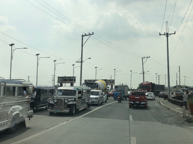
 Vehicles crowd on the two-lane bridge that is the new Barkadahan Bridge. The old one is currently being rehabbed. Notice the significant volume of trucks using the bridge? This is expected to increase due to the industrial developments in Rizal Province and along C-6, and the direct route this corridor provides towards the SLEX via Bicutan.
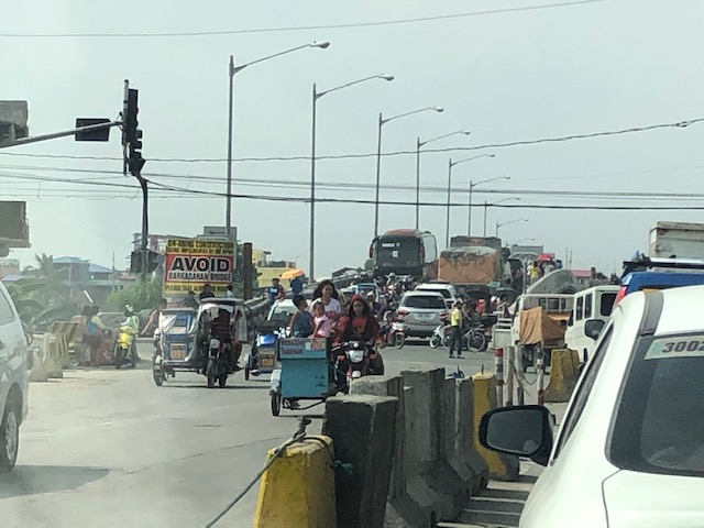
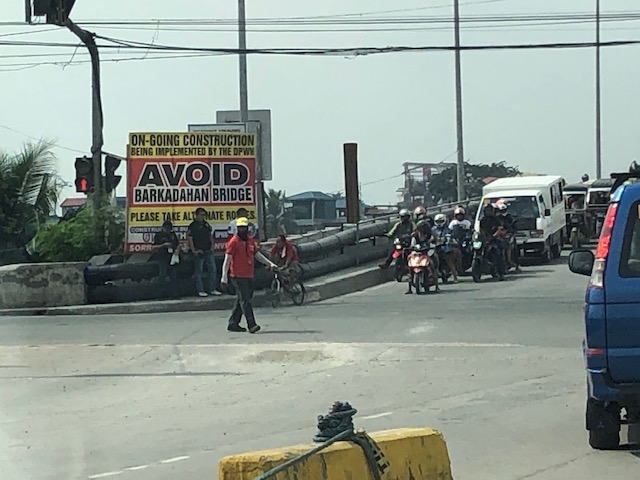 Big sign at the bridge – there are many of these scattered around Pasig and Rizal advising travelers against using the route and Barkadahan Bridge because for the construction work on the bridge. This ‘avoidance’ basically transferred (some say returned) much of the traffic to Ortigas Avenue Extension. Many if not most users of the bridge use this alternate route to travel from Rizal to BGC and Makati CBD.
 A peek at the construction work on the old bridge – note that the contractor seems to have completed installing the steel reinforcement for the slabs for this section of the bridge. The next phase would be the concrete pouring.
 Still another peek showing the extent of the work on the old bridge – my casual observation of the work areas was that there seems to be not so many workers. But then maybe it was a Sunday? Perhaps there should be more people working considering this is a very urgent project?
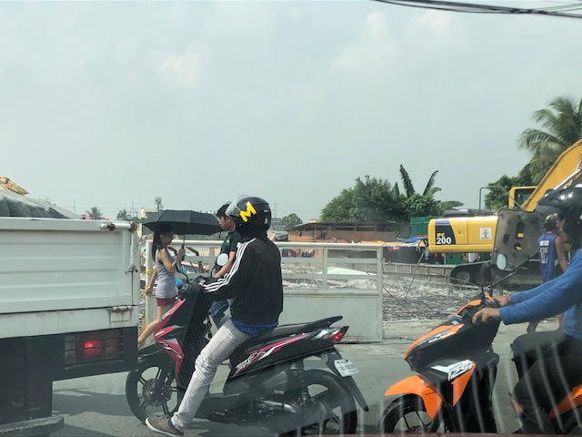
 Tricycles, motorcycles and bicycles – there’s a lot of local traffic using the bridge and these are represented by mostly tricycles serving the residential and commercial areas along the East and West Bank Roads and the cyclists you most often see crossing the bridge. Most motorcycles are through traffic. On weekends one can observe more recreational cyclists as this route is a popular one to Rizal and particularly its mountainous areas that are popular to mountain and road cyclists.
 Counterflow – many motorcyclists tend to counterflow and this adds to the friction and slows down traffic. Once the other bridge is completed and re-opened, these will likely be reduced to lane splitting or filtering as the opposite flows of traffic will be assigned to separate bridges. Counterflow traffic will then be very obvious and should be apprehended.
 Here’s the resulting queue on the other side of the bridge. This is severe congestion that reaches C-6. Note that the photo was taken on a Sunday. Perhaps these travelers have no other option but to use this route so they are stuck in hellish traffic on a Sunday? I can only imagine how worse it is on weekdays.
As a parting shot, I think there are still a couple of things that need to be addressed once the bridges are both open to traffic:
- Optimizing traffic management at the intersections with the East Bank Road and West Bank Road of Manggahan Floodway – the (mis)management of traffic here also contributes to congestion in the area. Traffic enforcers on both ends of the bridge have basic knowledge of how traffic must be managed and end up with the “buhos” approach. They don’t seem to be coordinating with each other, too. Their approach also heavily favors the East and West Bank roads when traffic is heavier along the main corridor that is C-6/Highway 2000. There needs to be a more efficient way to manage traffic here and that may be in the form of a sophisticated traffic signal system at least for the two intersections. Settings need to be studied and signals have to be adaptive to the variation of traffic throughout the day.
- Resolve bottlenecks in the area including structures that tend to reduce capacities of the approaches to the bridge.
More on this topic soon!
–
Boundaries of Rizal towns
You don’t see arches (arko) marking the boundaries of Rizal towns. A couple of weeks ago, I traveled to Baras where our office had its annual strategic planning workshop. Along the way, I drove along four towns – Antipolo, Teresa, Morong and Baras. There were few notable landmarks along my route unlike what I usually observe on trips to the north including the central Luzon and Ilocos towns where old buildings like churches and municipal halls (even houses) dot the way. Among the notables usually are the arches announcing your entry or exit to/from towns and provinces.
 Arch between Baras and Morong along the Manila East Road
 Signs marking the boundary of Teresa and Antipolo
Were there arches before for Rizal towns? Perhaps. What happened to them? Many probably were demolished due to road widening projects as the additional lanes meant the arches for the previous 2-lane roads became obstacles that increased the risk for crashes (i.e., vehicles crashing into them). I wonder now if the arches in Tarlac and Pangasinan towns survived the road widening projects there.
–
A little bit of history – on how the US interstate highway system came to be
Here’s one of those quick shares that I usually post here. I am a bit of a history buff and mixing that with transport will likely lead to a post like this. Here is a short article about an event in the history of the US Army that happened 100 years ago:
editor@aashto.org (2019) Celebrating Highway History: The US Army’s 1919 Cross-Country Convoy, aashto.org, https://aashtojournal.org/2019/07/12/celebrating-highway-history-the-u-s-armys-1919-cross-country-convoy/ [Last accessed: July 12, 2019]
The article was particularly interesting for me because of two items: the road conditions and the man behind the US inter-state highway system. It took them a little over 2 months to cross the continental US because of poor road conditions. Many people have no sense of history and appreciation of what has been accomplished over the years and how difficult it was to travel at the time. I haven’t done the cross country trip but I have close friends who’ve done it and are thankful for the generally good roads they could use for the experiential road trip. Meanwhile, the person in the article – then Lt. Col. Dwight D. Eisenhower – is a man who made his mark in history at first as the Supreme Commander of the Allied forces in the European Theater in World War 2, who would later on become President of the US. I read elsewhere that the US interstate highway system was designed so aircraft may use them as runways in cases when the US were at war and the enemy had bombed their airports and airfields (just like what the Japanese did in the Pacific).
Do we have similar accounts for our roads and bridges in the Philippines? Were there key persons who may or may not be larger than life figures instrumental in developing our road infrastructure with their vision and leadership (Marcos doesn’t count because of his bogus military record and corrupt regime)? It would be nice to compile these and perhaps it should be a collaboration between the Department of Public Works and Highways (DPWH) and the National Historical Commission (NHC). They could even get the history departments of local universities involved for us to understand the evolution of transportation in this country.
–
Reservoir roads – Part 2
Previously, I posted about the reservoir roads we crossed when we traveled to Baler, Aurora last April 2019. It’s been a while since that post so before I forget, here are more photos of those reservoir roads taken during our return trip from Baler.
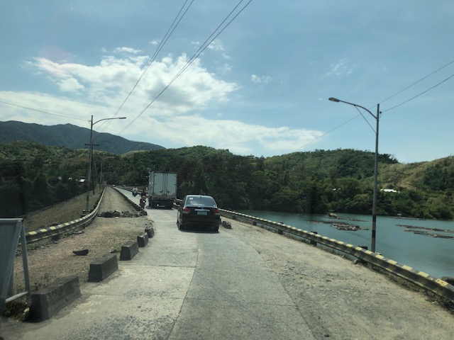
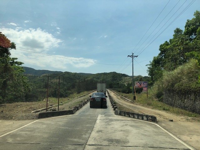 The two lane highway becomes a single lane section at the Diayo River Reservoir road
 A view of the fish pens at the Diayo River reservoir
 Pristine waters with the Sierra Madre mountain range in the background
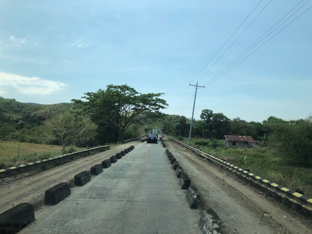 Approaching the end of the Diayo reservoir road
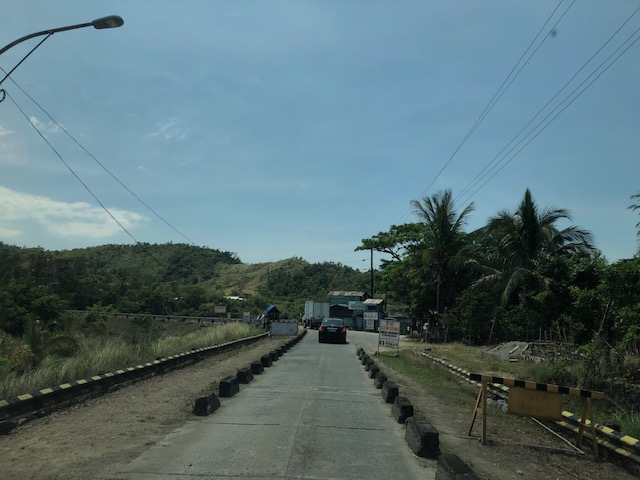 There is a checkpoint at the 2-lane section bridging the Diayo reservoir road with the Canili River reservoir road
 Vehicles entering the Canili reservoir road – this again is a one-lane, one-way section where vehicles from either direction would have to give way to either.
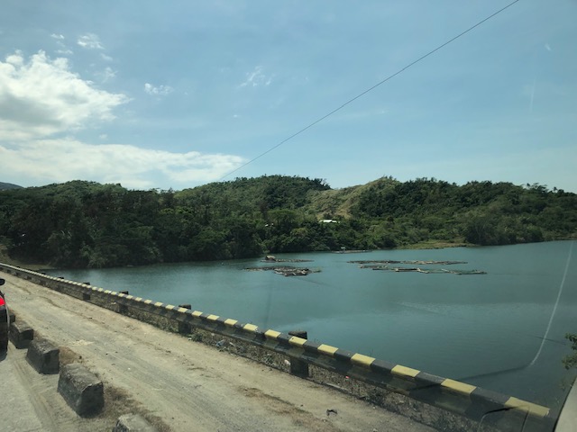 Shoulder and fish pens
 Waters of the Canili River Reservoir with the Sierra Madre mountains in the background
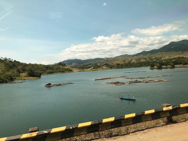 Fishermen on a banca – they looked like they were inspecting their fish pens
–
