
Home » Infrastructure (Page 26)
Category Archives: Infrastructure
Discouraging walking?
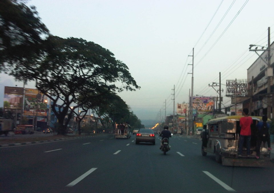
We were looking for suitable sites for a traffic survey along Espana the other day and had chosen the pedestrian overpass across Ramon Magsaysay High School as a possible site for a camera to record traffic flow along the avenue. Data from the video will be used to calibrate measurements from other cameras that are part of an intelligent system under development and supported by the DOST-PCIEERD. Those cameras are currently installed at a post at the junctions with Lacson Ave. and Vicente Cruz St. The system will also utilise data from the ASTI’s flood sensors near Lacson and San Diego. What we saw on the footbridge was not exactly a shocker to us as we anticipated the conditions on the overpass. However, we all agreed that the conditions of such pedestrian facilities need to be improved significantly and in such cases as this footbridge, immediately!
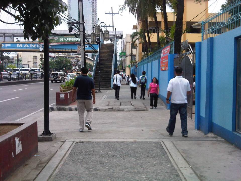 Walking to the overpass in front of Ramon Magsaysay with the school on the right.
 The overpass was partly flooded from the rains the past few days. The roofing only had the frame so anyone using the overpass on a rainy day would have to use their umbrellas for cover. The MMDA had removed the roofs of many overpasses to discourage vendors and beggars to set up on the overpasses. Spared from the campaign were overpasses that were secured by establishments like those along Katipunan with Ateneo and along Espana with UST. While there are no vendors or beggars on this overpass, it’s quite obvious from the photo that vandals have been busy defacing the facility.
 Many open overpasses like this are stinky because they are (ab)used as urinals. Who knows about the composition of these puddles aside from the rainwater during this wet season.
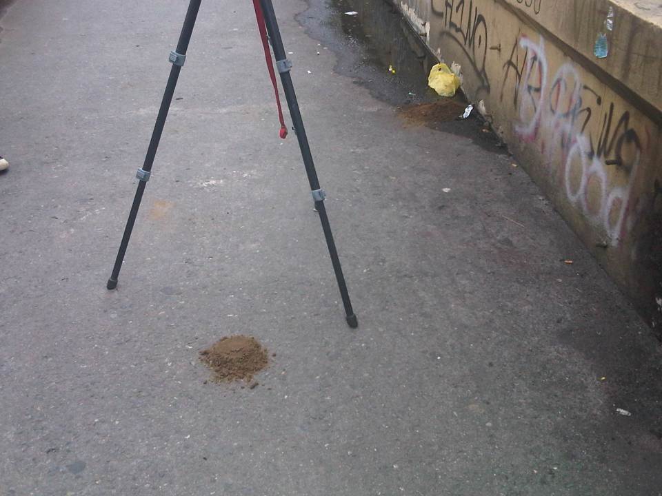 The overpass smelled of poop and that’s simply because there were poop scattered along the overpass. Neglected facilities like this, despite being used by many people (its right in front of a big public school) to cross busy streets like Espana, are often used by vagrants as toilets. Quick thinking and action by one of our staff reduced the stink when he got some soil from the (also neglected) plant boxes in the area to cover the feces that littered the overpass.
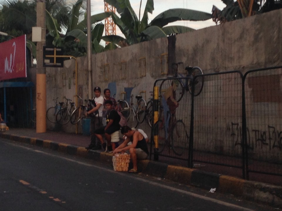
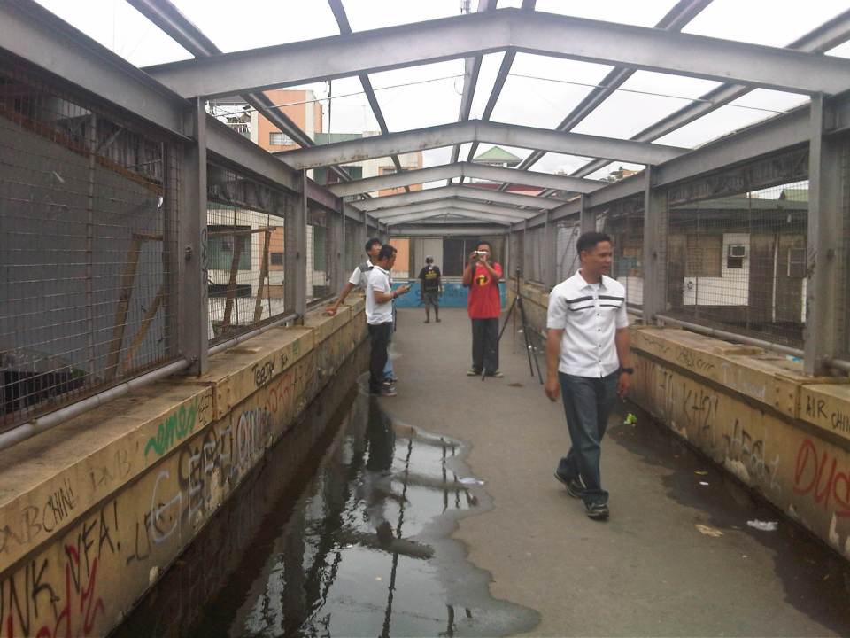 NCTS staff setting up a camera while also taking up the conditions at the footbridge.
 The stairways to/from the footbridge are quite steep. Such features need to be designed with senior citizens, children and PWDs in mind.
This overpass is located in Manila and is probably used by hundreds of students from the public school beside it aside from the other pedestrians that need to cross Espana Avenue. I think there is an opportunity here for the City of Manila and the specific barangay to improve the conditions of the facility and ultimately contribute to improving quality of life through the improvement of the quality of walking – the most basic of all modes of transport and certainly a strong indicator for a city’s health and vibrance.
–
We deserve better transport!
In the news lately are various problems pertaining to transport and the solutions authorities have come up with that they think are stop-gap solutions to alleviate the problems. The EDSA MRT Corp, for example, tried to experiment with a bus service to supplement the supply of transport for the tremendous demand for the MRT 3 trains. For some reason, the MRTC did not coordinate with the MMDA as well as the LTFRB for the experiment and this resulted in their buses being halted by the MMDA for being “colorum” or illegally operating public transport services. That quickly fizzled out even as they tried to convince queued passengers at stations to take the express bus instead.
More recently, this May, the MRT 3 experimented with what they called express trains. This was actually a “skip” train service where certain trains will not be stopping (i.e., skipping) certain stations. This was supposed to address congestion as well as improve travel times. It didn’t on both ends. Such services would have a chance if the MRT had the trains (rolling stock) for this kind of operation to be sustainable. Also, there’s the issue of the MRT tracks not being designed for trains to bypass stations with stopped trains (i.e., express trains bypassing local trains). That alone means there’s a limit to the number of trains you can deploy because there’s no way one can bypass the one ahead of it.
The MMDA recently re-introduced ferry services along the Pasig River. These are basically school buses loaded up on boats. While I’m sure the people behind this are well meaning, I couldn’t help but cringe with the idea that this seems to be the best we can do with the resources we have and agencies like the MMDA and the DOTC (especially the DOTC) seem content with their ideas for a solution to the transport/traffic mess we are in. Is it safe? So far, there have been no incidents yet so there are
The bottomline is that we do not deserve this low quality of transport services. The inefficiencies have directly or indirectly cost us a lot in terms of actual money or time that could have gone into more productive ventures. And the problem seems to be that many people have become manhid of their conditions and have taken transport matters in their own hands. Such comes in different forms like getting a motorcycle so they won’t have to take public transport or get caught in traffic jams. Another way is to get a second (even third or fourth) car so that the number coding scheme will not affect one’s trips. These examples, however, are more exceptions compared with the majority who cannot do anything about their plights except perhaps wake up earlier or stay at the office or school later so they don’t have to deal with traffic jams or difficulties of getting a ride.
I think we should voice out our displeasure with the current conditions and there are many ways to do this without going out in the streets to protest. That includes using social media to get the attention of those responsible for transport and traffic in your city or town. You just have to watch out for the trolls as there are many out there including those who seem to be working with the very same people responsible for transport and traffic. In such cases, you have to be careful how you react if someone heckles your posts. Actually, you shouldn’t mind them because otherwise, you would easily become frustrated or offended, which is what they want you to be. So you got to keep your cool and be patient with this social media approach. There are many advocacies out there that you can probably participate in and these include initiatives by competent NGOs who push for sustainable transport, inclusive mobility and clean air, among others. I like the term a friend coined from various experiences they had with their work on the Bus Rapid Transit (BRT) in Cebu and Manila – dignity of travel. We have to get back this dignity that has steadily deteriorated or degraded by the poor quality of our transportation systems.
–
Anxious about the LRT Line 2 Extension
Among the overdue projects that have generated much attention and, quite recently, some excitement is the extension of the LRT Line 2 from the current end station at Santolan, Pasig to Masinag Junction in Antipolo. This is a 4 kilometer stretch that has been viable for quite a long time now but somehow has not been constructed for various reasons. It was among the low hanging fruits that the current administration should have picked that could have been completed and operating now if it were started sometime 2011 (i.e., factoring in the transition in government after the 2010 Presidential elections). For some reason, government officials had to get proof that there was passenger demand for the extension by considering having another study undertaken just for this purpose. As I’ve mentioned before, one only needs to observe the situation at Santolan Station and perhaps the Sta. Lucia/Robinsons Metro East area to understand just how many people will benefit from the extension to Masinag. I would even dare say that you can even justify extending the line further to Cogeo. Following are a few photos I recently took along Marcos Highway along with some comments pertaining to the Line 2 extension construction.
 Soil testing site along Marcos Highway in Pasig City – these activities preclude the designs for the superstructure, which include the elevated tracks and the stations (there will be 2) along the Line 2 extension.
 Another soil test site – each location roughly correspond to the location of the columns that will be constructed to support the elevated tracks and stations.
 Scenes of overloaded jeepneys should no longer be the norm once the Line 2 extension is completed. However, such would probably be common for jeepneys coming to or from the last station at Masinag. There are no other choices for people taking public transport beyond Masinag except jeepneys bound for destinations like Antipolo Simbahan, Cogeo, Tanay and Marikina.
 Pedestrian overpasses such as this relatively new one near the Filinvest East main gate would have to give way to the elevated Line 2. Another option is for this and other overpasses to be reconfigured with respect to the future line. I just hope this will be done with utmost care so we won’t have overpasses similar to those along EDSA that go above or below the elevated tracks of the MRT 3.
 This overpass will like be removed to give way to the future end station of the Line 2 extension. The overpass in front of SM Masinag will have to be integrated with the station to be located in this area.
–
“Pwede na yan” bikeways?
The recent clamor for bicycle facilities have led to several initiatives in Metro Manila and other Philippines cities (most notable recently is Iloilo) to support the demand for cycling facilities. While Marikina City already has a network of off-street bikeways segregated from motorised traffic, there are few other examples of such facilities elsewhere. The more recent initiatives in Metro Manila involved the Metropolitan Manila Development Authority (MMDA) establishing bikeways in several areas along major roads in the metropolis. I say establish because the MMDA did not construct new bikeways like the ones in Marikina or Iloilo. What the agency did was to designate sidewalks and other existing paths for cycling by painting these over. Unfortunately, these so-called bikeways did not take into consideration the needs of pedestrians with whom cyclists must share this limited space. And so few people use them despite a high profile launch that brought together government officials and NGOs including cycling and mobility advocates and enthusiasts. I guess the big test was really not whether advocates and enthusiasts would really use the bikeways (Don’t count on the officials to use them. They have chauffeur-driven vehicles.). Would the regular commuter use them instead of the roads, despite the risk or dangers posed by motor vehicles?
 Commuters waiting for a bus ride along EDSA with suspended bicycle racks behind them. The sidewalks along EDSA have been painted red, designating them for bicycle use. The big question now is how cyclists will interact with pedestrians given the very limited space they should be sharing.
 Bicycles hanging on racks attached to the perimeter wall of an exclusive subdivision along EDSA.
 Cyclist using the curb side lane of EDSA – these people run the risk of being sideswiped by buses operating along the yellow (bus) lanes of this busy thoroughfare. It is quite obvious in the photo that there is no space on the sidewalks to accommodate cyclists and even pedestrians. Column for the MRT-3 stations are right on the sidewalks and makes one wonder how this flawed design was approved in the first place. MMDA enforcers usually appear as if they are only bystanders and seem to be generally helpless when it comes to managing traffic.
 Workers cycling back to their homes after a day’s work. Many people have opted to take bicycles for their daily commutes even if they have to travel long distances in order to save money that would otherwise be paid as fares for buses, jeepneys, UV Express or tricycles. Note that the cyclists use the outermost lane of the road as the sidewalks pose many obstacles including pedestrians as shown in the photo. Some cyclists though want more than a share of the sidewalk or a lane of the road for their use regarding pedestrians and motor vehicles as nuisance for them. Surely, some pedestrians also regard cyclists as nuisance to walking and would prefer to have the sidewalks for themselves.
Cycling is in a way an emancipation from motorized transport commutes, and savings translate to money they could allocate for other needs of their families. While there are raw data for family expenditures from census surveys, there are few studies and publications focused on transport. It would be interesting to see how much a typical Filipino family spends for transport in absolute terms as well as a percentage of their total incomes. Such information would be essential for understanding the needs of travelers, especially for daily commutes for work and school (other trips include those for purposes of shopping, recreational, social and others). Long commutes are associated with higher expenses (e.g., in terms of fares or fuel costs) and reducing such costs through shorter commutes should free up money for necessities like food, housing and clothing. Ultimately, this would help solve issues relating to poverty and health, which can easily be related to commuting behavior and characteristics.
It is in that context that transport systems should be planned and implemented carefully along with the housing developments. This underlines the essence of the relationship between transport and land use that has been the topic of discussions for quite some time now that apparently, a lot of people in this country, especially officials and the private sector have chosen to ignore or apply selectively (i.e., according to their own advantage and not really for the general welfare of the public). A transport system is not cycling alone, or roads or railways alone. It is, by definition, a network, a set of interacting, integrated elements and each of these components of the system are essential for it to function well. It is the interaction and integration that are the key elements that we often forget as we advocate one transport mode over others as if they are independent from each other. They are not and we should complement rather than compete in our advocacies for transport so we can finally achieve an efficient, effective system for everyone.
–
Some good reads on rural roads
A couple of articles came out recently on Rappler that focuses on rural roads:
Farm to market roads: a farmer’s journey, March 5, 2014
The future of rural roads, March 8, 2014
Both are solid articles and places our attention to rural roads and particularly farm to market roads (FMRs). There’s a wealth of information in the articles as well as the links embedded that allow us to see past and present efforts on rural roads. It is good that government with the help of international agencies are investing resources on these roads and we hope that this will be sustained in order to effect what has been touted as inclusive growth.
 Rural road connecting to a national highway in Palawan
Rural roads are an important and integral part of of our transportation system. Often, attention is placed on national roads, which are under the jurisdiction of the DPWH. Local roads, however, are under various entities including the Department of Agriculture and various levels of local government (e.g., provincial, city, municipal). Of course, there are roads that are rural but are national and therefore under the DPWH. But most roads are classified as local and therefore would not be directly under that national agency. In fact, 85% of our roads are considered local and those classified as rural comprise perhaps more than 70% of the total roads in the country (i.e., national roads can be urban or rural, and city roads include those in the rural parts of cities). Rural roads including FMRs are essential as they provide basic access to jobs, education, health services, markets and other services that could help alleviate poverty and promote development in rural areas.
–
Transport and traffic purgatory, paradise and inferno
A lot of people have been referring to the traffic congestion and other derivative issues that will be the result of the construction of several transport projects around Metro Manila as “traffic armageddon.” Some friend have appropriately (I think) referred to it more as “car-mageddon.” This seems to be the case since it is perceived to have the most impact on car users than public transport users, cyclists or pedestrians. This is far from the truth as there are more people taking public transport, cycling or walking than those driving their own cars. In fact, estimates for Metro Manila indicate that 70-80% of travelers take public transport while 20-30% take private vehicles. These mode splits do not include bicycles or walking, which obviously will further decrease private car shares.
I would rather refer to this period of construction as a sort of “purgatory” though it has nothing to do with the cleansing that’s associated with it. There is still the suffering involved while improvements are being implemented. But, most importantly, there is hope at the end of this process. This “hope” is not necessarily the “light at the end of a dark tunnel” kind of thing as surely population and the number of vehicles will surely increase over time even as the transport projects are being implemented. By the time these are completed, there are sure to be more people, more vehicles, as well as more of other developments that will put our transport system to a stress test. We can only hope that the designs of these infrastructure we are building now are based on honest to goodness trip or traffic forecasts. Otherwise, we’ll end up with congested or saturated systems by the time they start operating.
Unfortunately, most projects mentioned and those we know have the green light and would likely be proceeding with construction in the near future are basically road projects. It’s ironic considering that what Metro Manila urgently, and maybe desperately, needs now are public transport systems including the much delayed MRT 7, LRT 2 Extension and LRT 1 Extension. The proposals for Bus Rapid Transit (BRT) seem to be in a limbo, too, despite extensive studies and surveys to support BRT along corridors such as Ortigas Avenue and Circumferential Road 5. These are blamed on institutional and legal impediments including allegations of shortcomings among officials of agencies responsible for these infrastructure.
I am aware of an initiative led by an environmental lawyer seeking to effect the redistribution of road space in favor of public transport users, cyclists and pedestrians. I think such actions are useful from the perspective of getting the attention necessary to push government and private sector players to have a sense of urgency not just in words but also in actions in as far as transport infrastructure programs and projects are concerned. We are already lagging behind our ASEAN neighbors with regards to infrastructure and at this pace, it is likely that less developed countries like Cambodia and Myanmar might just overtake us in the foreseeable future. From another perspective, it is hard to push for sharing the road when people really don’t have better options for commuting. Walking and cycling are not for everyone and many people have turned to the motorcycle to solve their transport woes. In the latter case, motorcycles are perceived as a vehicle that’s fuel efficient and allows the users to zip through congested streets often at high risks of being involved in a crash or spill.
We can only achieve “paradise” in our highly urbanized cities if we build these mass transit systems along with the pedestrian and cycling facilities that will complement each other. Those for whom car travel is a necessity would also benefit from reduced road congestion so it will eventually (hopefully) play out well for most people. Meanwhile, we would have to endure transport and traffic hell (some more and longer than others) as the government and private sector embark on this round of infrastructure projects implementation. It helps to look back at our experiences with the last major batch of projects in the latter part of the 1990’s when the number coding scheme was first implemented. At the time, it was implemented as a temporary measure to alleviate congestion while projects where being implemented. What was a temporary measure is now still being implemented along with a truck ban that has also been evolving the past years with the latest being the one implemented by the City of Manila starting last February 24. Will these vehicle restraint schemes be modified to cope with the traffic congestion expected from projects like the Skyway connector? Will these be relaxed or removed after all these projects have been completed? Your guess is as good as mine.
–
Identifying opportunities with the MRT 7 and the LRT 1 extension
As we welcome 2014, we also look forward to major projects that will help alleviate transport and traffic problems in our cities and elsewhere in the Philippines. With the approval of the MRT 7 and LRT 1 south extension projects late last year, there should be less impedance to these much-delayed projects starting construction within the current term. These lines should have been built way back, – “ideally” in the 1980s, “practically” in the 1990s, and “urgently” in the last decade. At this time, I think the need for these lines are beyond urgent. I think perhaps we have reached the state of “desperation” is so far as mass transportation is concerned for Metro Manila and its surrounding cities and municipalities.
 MRT 7 map from a public presentation made by the line’s proponents about 5 years ago.
Opportunities that can be related to the MRT 7 and LRT 1 lines include land development that fall under the category of transit oriented development (TOD). I think the government should not be too dependent on the private sector for developments around and near the future stations of the rail lines. The prevailing assumption that the private sector will do what’s best is only applicable to themselves and not the public good. Note the difference between perspectives here where it is only to be expected that private companies will be concerned with their own bottom-lines, i.e., revenues generated towards the maximization of profits. Economic benefits are and should be treated or regarded differently from such a perspective. The latter is the responsibility of the government as it concerns the public good and interest, and with a more macroscopic and strategic scale, with a long-term vision for development.
One such opportunity concerns informal settlers and their resettlements to areas outside the CBDs. Why do these people keep on returning to the cities when they are already supposed to have been provided housing elsewhere (e.g., Bulacan, Laguna, Cavite, Rizal)? The answer seems almost automatic: they don’t have the means for livelihood where they have been relocated and access to basic services and jobs/workplaces is limited (i.e., very difficult). The government must be involved and very deliberate in developing lands for housing around or near rail stations such as those for the future MRT 7 development. It cannot rely on the private sector to push for public housing when, frankly, those companies are driven by their desires to maximize their profits rather than push for the public good. That’s a bit of reality that we must accept and we must factor in decision making. The government already lost a huge opportunity when the National Housing Authority (NHA) effectively gave away prime lands in Quezon City for an upscale development. I leave it up to the reader to check the mandate of the NHA. It could have pushed instead for a development much like the HDBs in Singapore, which are not located in the boondocks but in prime locations in the city state. It need not be purely residential but a healthy mix of commercial development should be pursued along the lines of equitable transit oriented development (TOD).
Note that it should be clear here that when I say public housing this does not necessary mean the mass housing or low cost housing we tend to associate with failed projects in the peripheral provinces to Metro Manila. These are more like multi-level, medium to high rise developments you now find in major cities in Japan, China, Thailand and Singapore, which can be the model development for replication in other cities around the country. These can be reasonably priced units that can be affordable in terms of payments over a reasonable period of time. The concept is not new as there have already been BLISS projects before and Quezon City continues to collaborate with private sector for projects like Smile, Sunny Villas and the current Bistekville. These should be extended not just to your middle class and upper class (yes, they do make investments and have their units rented out to derive income) but formulated for the lower income classes (e.g., informal settlers), which now occupy much lands with their shanties. “Formalizing” these settlements should be a priority and the best locations for such developments, I think, should be around stations. Of course, there should be clear rules regarding the neighborhood and these rules should be strictly enforced for the buildings and area to keep their integrity (e.g., no extensions to the balconies or windows).
The concept and application of land-banking is not new and has been used by the private sector especially major developers like Ayala Land, Filinvest, Sta. Lucia, SM and Robinsons. Properties are acquired based on criteria regarding their potential for development. These lands are usually of low value and in many cases the land use need to be changed in order for these to be developed (e.g., agricultural lands being converted into residential, commercial or industrial uses). The national government and local government units should also do land-banking perhaps to address issues, for example, on informal settlers. And land banking should be along transit lines that are being planned (e.g., in Bulacan for MRT 7, in Cavite for the LRT 1 Extension, in Rizal for the LRT 2 Extension, and in Laguna for the PNR Commuter Line) so that issues pertaining to access to jobs, education and other services can be addressed by such transport infrastructure.
We look forward to the government realizing such opportunities that have for so long been available yet it has not taken into serious consideration. These require both strategic and practical thinking to be able to undertake master planning for such developments and their implementation over the immediate to long terms. No easy task but if our leaders are focused and determined to see these through, there’s no reason why these cannot be implemented and operational soon. Hopeful we are for these things this 2014.
Happy New Year!
–
Designing for walking and cycling
There are current discussions regarding the highway and street designs mostly from the perspective of safety. These discussions include those hosted by the academe and those posed as challenges by practitioners, mainly architects with experience designing similar facilities abroad and who are advocating for more people-friendly designs. Such discussions are slowly but steadily gaining traction in the Philippines but has met with some resistance in the form of key persons and agencies not giving due attention to the design challenges being posed that would have implications on planning and design guidelines. That is, the implications of promoting people-friendly designs in our roads will require changes in the National Building Code as well as the Highway Planning Manual of the Department of Public Works and Highways (DPWH). These changes will include standards and specifications for the geometric design of walkways and bikeways integrated into our roads and a departure from the current approach that basically treats pedestrian and cycle facilities as an afterthought to motorways.
I’m posting a few photos I took from a recent visit to Yokohama, Japan, which was my home for 3 years back in the 1990s. Much has changed in Yokohama since I last visited in 2008 but notable are the people friendly transport infrastructure including pedestrian and cycling facilities. Following are photos taken in the Minato Mirai district of the city.
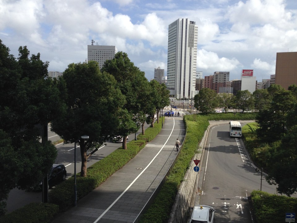 Pedestrian and cycling lanes along the main road of Yokohama’s Minato Mirai district. The tree-lined street provides a conducive environment for walking and cycling.
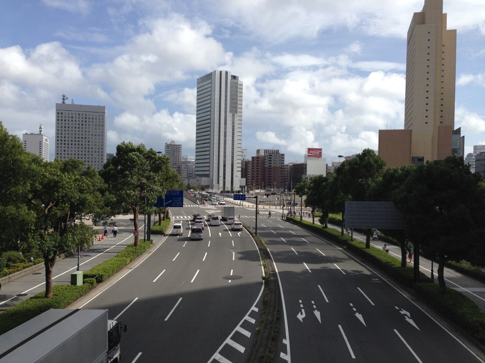 Depending on how one sees it, Minato Mirai Odori is a 10-lane road with 4 lanes allocated for walking and cycling (i.e., 1 lane each on either side of the lanes for motor vehicles).
 Pedestrian bridge connecting Minato Mirai Odori with the World Porters commercial development
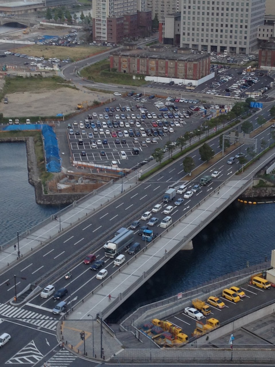 A 10-lane bridge with 2 of 5 lanes per direction devoted for walking and cycling. That’s a full lane of at least 3.2 meters allocated for pedestrians and another full lane for cyclists. While it is not shown in the photo, the pedestrian and cycling lanes are efficiently utilized during the peak periods.
–
#ReliefPH: Access and needs in many other places
The buzz on the streets and on social media is the focus on Tacloban, Leyte when vast areas and many other towns and provinces have been ravaged by super typhoon Yolanda (Haiyan). This seems unfair to other cities and municipalities considering Yolanda made 6 landfalls at or near peak strength (as a Category 5 typhoon) with winds topping 225 kph and generating destructive storm surges as it hammered through the central Philippines.
If you have Facebook, one provincial government staff has posted a lot of photos describing the situation in the northern towns of Iloilo where the destruction caused by the typhoon is very clear and to many, still unimaginable. These photos along with all others that can be Googled, Yahooed or found via other search engines or news agencies show the extent of the damage brought about by Yolanda.
Some people say that the islands of Cebu, Panay, Negros and Mindoro are fortunate as principal cities in those islands like Cebu City, Iloilo City, Bacolod City, Dumaguete City and Calapan City were relatively undamaged. This is also true, and so the airports and ports in these cities provide direct access to the islands for relief work. Moreover, government agencies and private entities have been able to organize relief activities through these cities and based on various news reports, it looks like a lot of people are already involved in these activities. That goes without saying that more people are still needed to be involved in various capacities for relief, rehabilitation and reconstruction work that are expected to be undertaken over a longer term considering the extent of the damages to towns. But given the circumstances for the said islands, there is no excuse for more rapid aid not being able to reach the affected towns in these provinces. In fact, much more is expected where accessibility is no longer an issue and so faster recovery is possible for Panay, Negros, Cebu and Mindoro. In the cases of Cebu and Bohol, it is important to remember that the provinces already are also still reeling from the impacts of the Magnitude 7.2 earthquake that occurred only a few weeks ago.
On another note…Tacloban Airport is still closed to commercial aircraft but the land routes via RORO or the nautical highways are open to traffic or operational. I think the quickest way to Leyte is via the route from Cebu. There are regular RORO and Supercat services between Cebu City and Ormoc City in Leyte. There are other maritime transport services from Bogo City in northern Cebu but I am not sure those services are back to normal. Then there are also access via the Eastern Nautical Route via the Bicol Region and crossing over to Samar Island (Allen) via Matnog, Sorsogon. Many roads still need to be cleared but the main highway (Pan Philippine Highway) including the San Juanico Bridge that connects the islands of Samar and Leyte.
–
Proposal for a Special Mass Transit Support Fund
There are three bills currently being discussed at the Senate that were filed by Sen. Ralph Recto. These propose the restructuring of the special funds derived from the Motor Vehicle Users’ Charge (MVUC) in order to allocate funds for mass transportation.
Senate Bill 446 – An Act Creating The Special Mass Transit System Support Fund, Reallocating The Disposition of Monies Collected From The Motor Vehicle User’s Charge, Amending For The Purpose Sections 7 And 8 Of Republic Act No. 8794, Otherwise Known As The Motor Vehicle User’s Charge Act of 2000.
Senate Bill 611 – An Act Creating The Special Mass Transit System Support Fund To Provide Additional And Long-Term Funding To Priority Mass Transit Projects In The Greater Metro Manila Area, Amending For The Purpose Sections 7 And 8 Of Republic Act No. 8794, Otherwise Known As The Motor Vehicle User’s Charge Act of 2000.
Senate Bill 621 – An Act Creating The Special Mass Transit System Support Fund Amending For The Purpose Sections 7 And 8 Of Republic Act No. 8794, Otherwise Known As The Motor Vehicle User’s Charge Act of 2000.
The National Center for Transportation Studies (NCTS) was requested to submit a position paper on these bills by the Senate Committee on Public Works that is chaired by Sen. Ferdinand “Bongbong” R. Marcos, Jr. The Center drafted one and submitted the 4-page document to the Committee secretariat last October 16, 2013. A copy of the position paper may be downloaded from the following link:
NCTS PositionPaper MVUC 16Oct2013
The Senate Committee on Public Works held a public hearing last October 17, 2013 at the Lorenzo Tanada Room at the Senate. The NCTS Director, Dr. Hilario Sean O. Palmiano, was invited as a resource person for the hearing and joined representatives of agencies such as the DPWH, DBM, DOF, LTO and the Road Board in providing insights and comments on the proposed bills. The same agencies were also requested to provide pertinent data for the committee to evaluate the proposed changes to R.A. 8794. Such data include information on past disbursements and approved projects that used the special funds under the MVUC.
–
