
Home » NMT (Page 11)
Category Archives: NMT
Walking in Singapore
The recent trip to Singapore was like a sentimental journey for us. We had lived in the Lion City for almost 2 years and consider this a second home (actually a close third for me because I consider Yokohama as a second home having lived there for 3 years). Among the things we truly missed about Singapore aside from friends (many of whom have already moved to other countries) and food were the public transport and the walking. Singapore is a walkable city and the excellent public transport along with the land use planning has allowed healthier commutes for people.
 The environment along Orchard Road is inviting and conducive for walks.
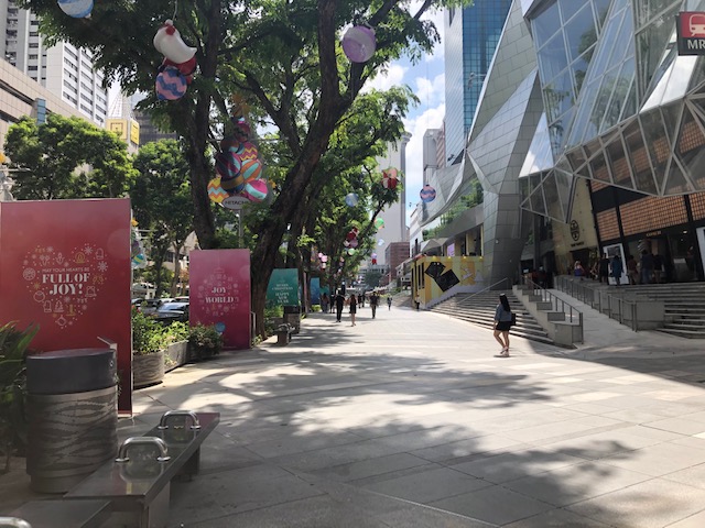 Wide sidewalks can accommodate more people and don’t make it feel so crowded even during the peak hours.
It was easy to log more than 10,000 steps per day in Singapore. In fact, I was happy to have walked an average of 11,000+ steps per day for the 3 days were there. One could only hope we can have similar infrastructure in the Philippines.
More on walking and public transport in Singapore soon.
–
Is there really a transport or traffic crisis in Metro Manila?
I was interviewed recently for a research project by students enrolled in a journalism class. I was asked by one in the group if we indeed have a transport crisis in Metro Manila. The other quickly added “hindi transport, traffic” (not transport but traffic). And so I replied that both terms are valid but refer to different aspects of the daily travel we call “commuting”. “Traffic” generally refers to the flow of vehicles (and people if we are to be inclusive) while “transport” refers to the modes of travel available to us.
“Commuting” is actually not limited to those taking public transportation. The term refers to all regular travel between two locations. The most common pairs are home – office and home – school. The person traveling may use one or a combination of transport modes for the commute. Walking counts including when it is the only mode used. So if your residence is a building just across from your office then your commute probably would be that short walk crossing the street. In the Philippines, however, like “coke” and “Xerox”, which are brands by the way, we have come to associate “commute” with those taking public transportation.
And so we go back to the question or questions- Do we have a transport and traffic crises? My response was we do have a crisis on both aspects of travel. All indicators state so and it is a wonder many including top government transport officials deny this. Consider the following realities for most commuters at present:
- Longer travel times – what used to be 30-60 minutes one-way commutes have become 60 – 120 (even 180) minute one-way commutes. Many if not most people now have double, even triple, their previous travel times.
- It is more difficult to get a public transport ride – people wait longer to get their rides whether they are in lines at terminals or along the roadside. The latter is worse as you need to compete with others like you wanting to get a ride ahead of others.
- People have to wake up and get out of their homes earlier – it used to be that you can wake up at 6:00AM and be able to get a ride or drive to the workplace or school at 7:00/7:30 AM and get there by 8:00 or 9:00AM. Nowadays, you see a lot of people on the road at 5:30AM (even 4:30AM based on what I’ve seen). That means they are waking up earlier than 6:00 AM and its probably worse for school children who either will be fetched by a service vehicle (e.g., school van or bus) or taken by their parents to their schools before going to the workplaces themselves.
- People get home later at night – just when you think the mornings are bad, afternoons, evening and nighttimes might even be worse. Again, it’s hard to get a ride and when you drive, traffic congestion might be at its worst especially since most people leave at about the same time after 5:00PM. Coding people and others not wanting to spend time on the road (instead working overtime – with or without additional pay) leave for their homes later and arrive even later.
- Less trips for public transport vehicles – traffic congestion leads to this. What used to be 6 roundtrips may now be 4. That affect the bottomline of income for road public transport providers. Given the increased demand and reduced rolling stocks of existing rail lines that includes rail transport.
To be continued…
—
Tartanilla – Calesas in Cebu City
We spotted these calesas or horse drawn carts while walking around downtown. These are also called ‘tartanilla’, which is familiar to us since its the same term used in Cagayan De Oro for their version of this transport mode. Here are a few photos:
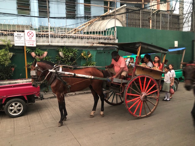 Although mainly used for tourism purposes in Manila, the tartanilla in Cebu seems to enjoy some non-tourist ridership. Most of the passengers we saw riding them didn’t look like tourists.
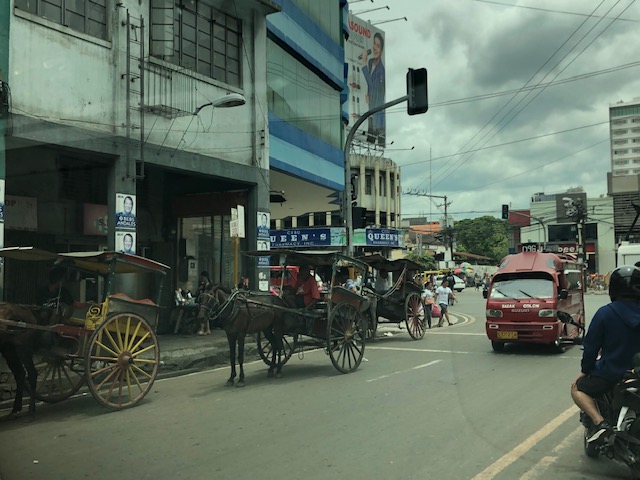 There are on-street stations for these tartanillas.
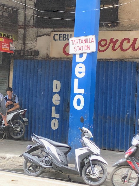 Tartanilla station sign – the stations appear to be informal but I guess the city is regulating their services and retaining them as part of the heritage of the city.
–
Road safety week and some helpful articles
This week is the UN Global Road Safety Week. And so, I will be sharing some articles and references related to road safety including the following pertaining to crashes involving bicycles and motor vehicles:
Bicycle Accident Prevention: Avoiding the 12 most common types of bicycle/vehicle accidents
Link is here: https://www.bicycleaccidentprevention.com/?fbclid=IwAR2JnbQQR9rwg_Vz6rOLZtQ0sxnlyn3zPojBgg_-XoUKED69p0EFFtPdlRY
The only comment I have about the above reference is that it still uses the term “accident” instead of “crash”. The latter is the more appropriate term now being used by professional, advocates and policymakers who are focused on safety; keeping in mind the motto that “road safety is no accident”.
–
Article on sustainable transport’s role in “saving the world”
Here is another quick post on another article I am sharing showing the importance of sustainable transport:
Milner, D. (2019) How sustainable transport can save the world, medium.com, https://medium.com/@djjmilner/how-sustainable-transport-can-save-the-world-f2f64517dc52 [Last accessed: 4/9/2019]
It goes without saying that sustainable transport has a lot of potential for helping mitigate climate change and other issues but much is expected of our leaders for policies and program & project development & implementation towards achieving sustainable transport in our cities and municipalities.
–
Some concerns about future rail ridership
Traveling along Commonwealth Avenue and Marcos Highway the past week, I both hopeful and worried about what happens after the Line 7 and Line 2 Extension finally becomes operational. Much has been said or reported about the potential of these two lines to change the way people commute; at least from the areas served by these two mass transit lines. However, how big an impact these would have in terms of actual reduction of private car use remains to be seen.
Will there be significant decreases in the volume of motor vehicles along Commonwealth Avenue, Marcos Highway and Aurora Boulevard? Or will there be just the same traffic along these roads? The worry is based on the likelihood that those who would be taking Lines 2 and 7 would be people who are already taking public transportation and not those who have chosen to leave their cars (or motorcycles) at home.
Our students have been studying ridesharing and P2P bus operations the past few years and the conclusion has so far been a shift from one mode of public transport to what’s perceived as a better one. It’s somewhat a difficult thing to accept for advocates of public transport especially those behind TNVS, P2P buses and railways but it is what it is, and its important to accept such findings in order for us to understand what’s going on and come up with better ways to promote public transport and convince car users to use PT.
 Traffic flows at the Masinag junction with the Line 2 Masinag Station and elevated tracks in the background
What is more intriguing is the proposed subway line for Metro Manila. The alignment is different from the ones identified in previous studies for the metropolis and from what I’ve gathered should have stations that serve a North-South corridor that should make for a more straightforward commute (i.e., less transfers) for those taking the subway.
 Probable MM Subway alignment (from the internet)
It is another line that has a big potential as a game-changer for commuters but we won’t be able to know for sure until perhaps 5 or 6 years from now. What we know really is that there was a lost opportunity back in the 1970s when government should have pushed for its first subway line instead of opting for the LRT Line 1.
–
Reference on bike-focused street transformations
There’s an update to the “Rethinking Streets” guide with one that is focused on street transformation for bicycles. Here is the link to their site where they now have 2 guidebooks:
http://www.rethinkingstreets.com
You will have to click one of the guides to register (if you haven’t done so before) and download them.
–
References linking transportation and health
The Institute of Transportation Engineers (ITE) features several resources discussing the linkage between transportation and health. Here is the link to the page where they list references like reports from various sources as well as tools.
This is definitely a topic that needs more attention and studies in the Philippines in order to have local evidence (there are already strong evidence abroad) supporting active transportation and how it helps make citizens healthier. Of course, that goes without saying that active transport should be integrated with an efficient public transport system. That is so that the increasing share of private transport can be checked (no thanks to Grab and Uber) and we can either retain or increase public and active transport shares.
–
Marikina’s Bike and Parking Lanes
I had to navigate through Marikina’s streets in order to reach the Feliz Mall from the city’s downtown. Normally, I would have taken the more straightforward route that would have involved traveling along Marcos Highway. However, I couldn’t because it was my number coding day and the U-turn slots in the area are usually “swarming” with MMDA and Pasig City traffic enforcers. Marikina’s streets though were not part of the coding scheme and you only need to be familiar with their road network including which streets are one-way in order to navigate the streets properly.
 The bike lane is on the left side of the one-way road and to the right of the on-street parking spaces. The parking lane is the left-most and curb-side.
 This actually qualifies as an example of a road diet application. These could have easily been 2-way streets before but effectively 2 lanes have been allocated for traffic flow while the others are for parking and cycling. [Of course, hard-core cyclist will say only one lane was taken away from motor vehicles.]
These bike and parking lanes were implemented in connection with the Marikina Bikeways project that was initiated during the time of then Marikina Mayor Bayani Fernando in the late 1990s. The project was continued and maintained by succeeding administrations of the city and contribute to the city’s being more liveable compared to other LGUs. The reconfiguration of the streets make them safer and saner in terms of traffic flow where “traffic” is referred to as inclusive of all users.
–
The Ortigas Center bike lanes, complete streets and road diets
The MMDA recently stated they were planning to apply the road diet concept to EDSA by narrowing the current lane widths in order to add one lane per direction. While the idea seems to of good intention, the mention and application of road diet is flawed. I have previously shared an article on social media showing the definition and examples of complete streets:
Clearly, complete streets are for the benefit of everyone (i.e., inclusive) and not biased for motor vehicles. Here is a photo of F. Ortigas Ave. at the Ortigas Center in Pasig City showing the correct application of the Complete Streets and Road Diet concepts to an urban street. Note the elements for cycling and walking that are very prominent in the re-design of the street.
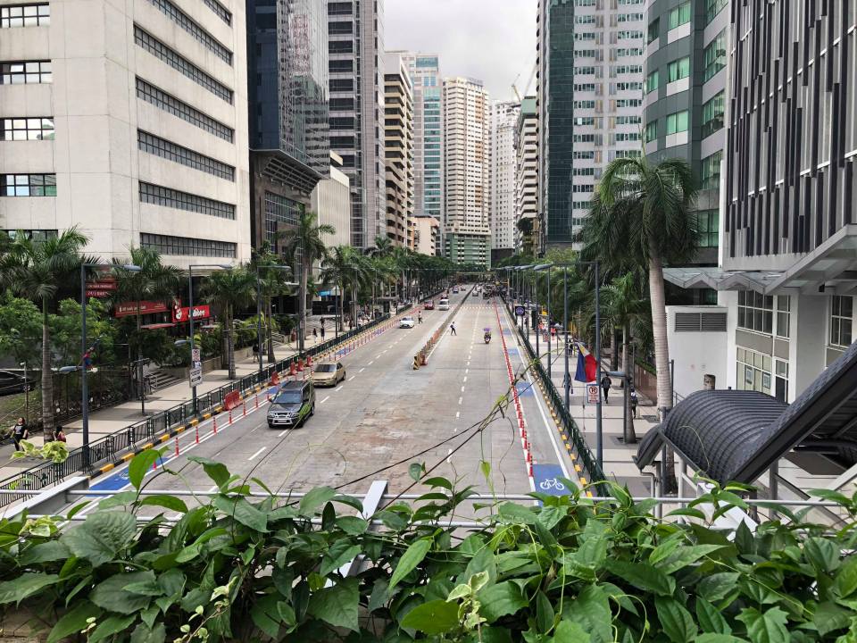 Protected bike lanes at either side of F. Ortigas Ave. at the Ortigas Center
We hope to see more of these re-designs in many other cities and towns in the Philippines. It is not a really difficult concept to apply or adopt as technically these are not complicated. However, there needs to be a change in the mindset of planners and engineers when they do these exercises considering how car-oriented our designs are. It is easy to say we want more people-oriented transportation facilities until it dawns on us how dependent we are on cars and resist the efforts to realise more sustainable designs.
–
