
Home » Pedestrian (Page 5)
Category Archives: Pedestrian
Bike lanes at the UP Diliman campus – Part 1
I had first read about the enhanced bike lanes at the UP Diliman Academic Oval last month from a social media post of a friend. She was present as the delineations of the jogging and cycling lanes were being painted along with the baybayin marks distinguishing UP’s bike lanes from others like it. UP’s bike lanes predate the current ones around Metro Manila that mostly popped-up during the pandemic.
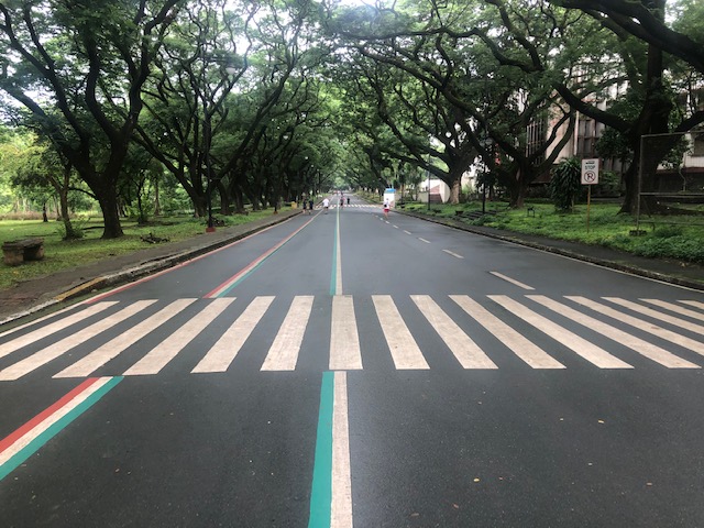 The Academic Oval road original had two-way traffic along its wide carriageway, that could easily fit 4 lanes. Since it became a one-way, counterclockwise road, the lanes had been divided into 3 wide lanes with one lane initially committed to bicycles.
 Here are the two lanes designated for joggers/walkers (curbside) and cyclists (median). The pedestrian sidewalk was originally planned to be widened in time for UP’s Centennial celebration back in 2008. That did not materialize. The Academic Oval could have had wider sidewalks for those who are not walking for exercise.
 The section in front of Melchor Hall features the words bicycles or bike lane and pedestrian in baybayin. Its certainly a novelty for now and something probably apt for the campus roads but not necessarily for others.
 A closer look at the baybayin script along the jogging/walking and bike lanes.
 Here’s the bigger picture on the pavement markings.
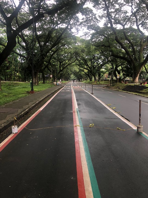 Approach to an intersection
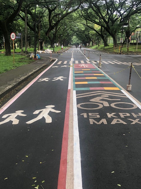 The UP colors inform riders about the intersection ahead. These are more visual as they are flat and not rumble strips. The older pavement markings advising riders of the speed limit should be seen in the context of utilitarian cycling (e.g., bike to work, bike to school) rather than cycling for fitness or recreation, which obviously may involve higher speeds and is frowned upon along the oval.
 The intersection approach from another angle.
The Academic Oval bike lane is one of the original recommendations of a transport study conducted for the campus about 17 years ago. The study was the basis for the campus being declared as a road safety zone, which among others included a provision for its roads to have a 30-kph speed limit. The one-way counter-clockwise traffic circulation and the jogging and bike lanes, however, are officially a part of what has become a long-term experiment on campus. There are many who oppose the one-way scheme and are vehement against the ultimate plan to have the Academic Oval car-free or car-less (it is mostly car-less during Sundays – part of the “experiment”).
The other new bike lanes on campus in Part 2 of this series.
–
A Bike Master Plan for Metro Manila, Metro Cebu and Metro Davao
Before Active Transport Week concludes this weekend, I would just like to share this collage from one of our staff at the National Center for Transportation Studies of the University of the Philippines Diliman. It is about the Master Plan developed for the three metropolitan areas in the country – Metro Manila, Metro Cebu and Metro Davao. I will share more details about this soon including a link or links to where you can download a copy of the plan.

The project concluded recently with the submission of the Final Report but most important is the Master Plan document that can serve as a reference for further development of bike lanes in the metropolises. I’ve seen the Master Plan and many of its provisions and recommendations can easily be adopted or is replicable in other cities and municipalities in the country. Perhaps, there should be a National Master Plan?
–
On the right to a walkable life
Here is an article from a perspective that’s very relevant today everywhere. We need to examine our daily routines particularly when it comes to commuting or moving about. Do we live in walkable communities? Is walking to certain places like school, the market, or the office an option to many of us? Or do we automatically choose to ride a car, a tricycle or motorcycle to get to these places?
Malchik, A. (May 13, 2022) “Driving is killing us,” Medium.com, https://antoniamalchik.medium.com/driving-is-killing-us-6a1b35158458 [Last accessed: 5/28/2022]
To quote from the article:
“Ask yourself this question: if you stepped foot outside your door, would you be able to walk anywhere you needed or wanted to go? Can you walk to a store, a library, school, or work? If your answer is “no,” what’s stopping you? Distance, highways, private property, broken or absent or inaccessible sidewalks? …
The loss of walking as an individual and a community act has the potential to destroy our deepest spiritual connections, our democratic societies, our neighborhoods, our freedom, our health, and our lives. But we can reclaim it. We can start to make a world that welcomes the walker, the pedestrian, rather than paving over that incredible human inheritance.”
I myself have enjoyed the benefits of walking when I was a college student in UP, when I was studying abroad in Japan, when we lived in Singapore and now in our community in the midst of the pandemic. I always think about opportunities and even schedule times for walking. Nowadays I am even conscious of my daily step count, which I equate with being active.
–
On phasing out cars in cities
I’m sharing another article on reducing car dependence. The article was referred to by the previous series that I shared recently.
Nicholas, K. (April 14, 2022) “12 best ways to get cars out of cities – ranked by new research,” The Conversation, https://theconversation.com/12-best-ways-to-get-cars-out-of-cities-ranked-by-new-research-180642 [Last accessed: 5/20/2022]
Here are a few excerpts from the article:
“Question: what do the following statistics have in common?
The second-largest (and growing) source of climate pollution in Europe.
The leading killer of children in both the US and Europe.
A principal cause of stress-inducing noise pollution and life-shortening air pollution in European cities.
A leading driver of the widening gap between rich and poor urban residents.Answer: the vehicles on our streets, primarily the not-so-humble passenger car.”
also this:
“The research is clear: to improve health outcomes, meet climate targets and create more liveable cities, reducing car use should be an urgent priority.”
and this:
“To meet the planet’s health and climate goals, city governments need to make the necessary transitions for sustainable mobility by, first, avoiding the need for mobility (see Paris’s 15-minute city); second, shifting remaining mobility needs from cars to active and public transport wherever possible; and finally, improving the cars that remain to be zero-emission.”
You can also listen instead of reading it as it is a narrated article.
–
On walkability and walkability scores
I’m sharing a couple of articles on walkability and walkability scores. The first one actually points to the second but provides brief insights about the concept of walkability while the second is a more detailed article on the findings of a study on walkability.
Ionesco, D. (May 4, 2022) “Walkability Scores Don’t Tell the Whole Story,” Planetizen, https://www.planetizen.com/news/2022/05/117075-walkability-scores-dont-tell-whole-story?utm_source=newswire&utm_medium=email&utm_campaign=news-05052022&mc_cid=c04e3e4dc0&mc_eid=9ccfe464b1 [Last accessed: 5/7/2022]
To quote from the article:
“if cities truly want to be pedestrian-friendly, they need to think beyond the sidewalk…”
The second article is from late April:
Gwam, P., Noble, E. and Freemark, Y. (April 28, 2022) “Redefining Walkability,” urban.org, https://www.urban.org/features/redefining-walkability [Last accessed: 5/7/2022]
To quote from the article:
“To create a more comfortable walking experience, our research points to a few steps DC planners and policymakers can take to increase racially equitable walkability across the city:
-
expand tree cover in the densest parts of the city,
-
increase nonautomotive modes of transportation in central areas,
-
reduce noise pollution,
-
support more equitable access to key resources, and
-
prioritize road design that limits the need for police traffic enforcement.”
While the article puts emphasis on the topic of racial equity, such concept can easily be adapted and adopted for our purposes. For one, it could be interpreted as being inclusive if one is not comfortable with the term “race”.
Don’t miss downloading the technical appendix of their report. This will be very useful to researchers, practitioners and advocates of active transport.
–
History: article on how jaywalking came to be
I am sharing this article on the invention of jaywalking. It is a very informative articles and gives context to the current situation where cars dominate streets and car-centric policies and infrastructure diminish pedestrians and walking. I’ve always said that history should enlighten us about how it was, how it came to be and what we need to change now if we are to attain a more sustainable transport system that will contribute to improving safety and ultimately, quality of life.
Thompson, C. (March 29, 2022) “The invention of ‘Jaywalking’,” Marker, https://marker.medium.com/the-invention-of-jaywalking-afd48f994c05 [Last accessed: 4/2/2022]
To quote from the article:
“It’s not totally clear who invented the phrase, but it was a fiendishly clever portmanteau. In the early 20th century, the word “jay” mean an uncultured rube from the countryside. To be a “jaywalker” thus was to be a country bumpkin who blundered around urban streets — guileless of the sophisticated ways of the city…
Ever after, “the street would be monopolized by motor vehicles,” Norton tells me. “Most of the children would be gone; those who were still there would be on the sidewalks.” By the 1960s, cars had become so dominant that when civil engineers made the first computer models to study how traffic flowed, they didn’t even bother to include pedestrians.”
The article showed photos of pre-automobile times in the US. Here’s a photo of pre-automobile Manila for context:

And here’s Manila during the American period but with most people walking or taking public transport in the form of the tranvias:

Chaotic as the scenes appear to be, these streets were definitely safer and perhaps saner than what he have now. The challenge is how to re-orient our streets and reclaim it to favor people instead of cars.
–
Article on evaluating transport equity
Here is another quick share of an article on transportation equity:
Litman, T. (February 2, 2022) “Evaluating Transportation Equity: ITE Quickbite,” Planetizen, https://www.planetizen.com/news/2022/02/116058-evaluating-transportation-equity-ite-quickbite [Last accessed: 2/4/2022]
Transportation equity is a very relevant, very timely topic as people in the Philippines are just beginning to understand and weigh the advantages of having more efficient transport in the forms of active and public transport over private vehicles.
–
Safe streets for children
We have been working with UNICEF and several partner organizations on a project on Child Road Traffic Injury Prevention (CRTIP). The Final Reports for the two pilot cities, Valenzuela City and Zamboanga City, have been submitted and represents over 2 years work including during the lockdowns due to the Covid-19 pandemic. The latter part of project implementation indeed became a challenge as we couldn’t travel and engage face-to-face or conduct field surveys like how we did in the first part of the project. Still, I believe we were able to accomplish much and most of what we initially set out to do. Here are the covers of the Final Reports we submitted to UNICEF and we understand will be officially or formally transmitted to the two cities.


The reports narrate the surveys conducted for 25 schools in Zamboanga and 41 schools in Valenzuela. Each initially had selected 25 schools but Valenzuela pushed for an additional 16 schools midway into the project. The SR4S tool developed by iRAP was used for the assessments of critical areas around the schools. The initial assessments were used to identify interventions to improve safety in these areas and recommendations were submitted for consideration of the cities as well as the DPWH where applicable (i.e., the DPWH has jurisdiction over national roads and improvements proposed along these). While some interventions were implemented, others and many were delayed mainly due to Covid-19.
We also conducted a survey to determine the commuting characteristics of schoolchildren in both cities. Since most schools were public schools, it was no surprise that most children lived near the schools or within the school district (which is basically the catchment area for these schools). Thus, it also came as no surprise that most schoolchildren came by foot (walking), motorcycles (riding with a parent) or motor tricycle. There’s a lot of information and takeaways from the data but unfortunately, we could get the bigger, more complete picture of Valenzuela City because they selected only elementary schools covering students from Grades 1 to 6. Zamboanga had a more robust data set with both elementary and high schools, covering Grades 1 to 12. The information derived from these surveys were also analyzed and related to the SR4S assessments. The commuting survey results and SR4S assessment are subject of two technical papers presented in the recent EASTS 2021 conference hosted by Hiroshima University.
What’s next? We are now drafting a proposal for a Phase 2 of the project. We hope to continue and reinforce and follow-up on the recommended interventions from Phase 1. We also hope to be able to work on the CRTIP data hub that was only partly completed due to the many constraints faced by that part of the project. I will post here from time to time about some of the outcomes from the surveys and assessments.
–
On defining the 15-minute city
I have shared articles and briefly written about the concept of the 15-minute city on this blog. Here is another discussing how a 15-minute city is defined:
(February 8, 2021) “Defining the 15-minute city,” Public Square, https://www.cnu.org/publicsquare/2021/02/08/defining-15-minute-city [Last accessed: 8/10/2021]
Here is an image from the article:
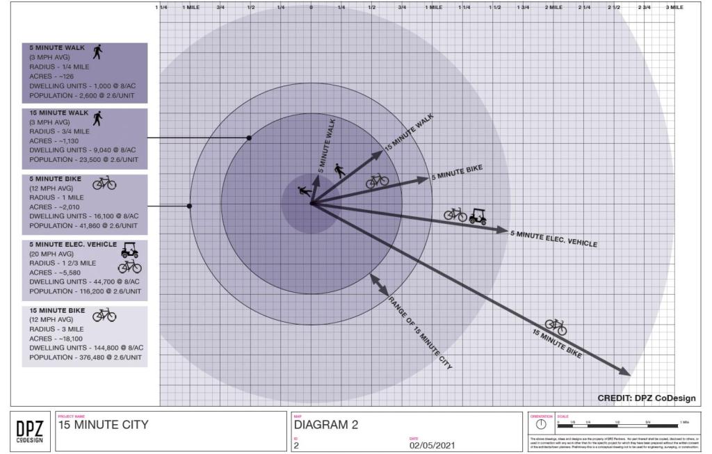
Again, it is important to contextualize these concepts. I share these as references and topics for discussion. Of course, I have my own opinions about this and I have written about those in previous posts. I guess in the Philippine context, we can include the pedicab or non-motorized three-wheelers in the discussion. These are also very popular modes in many cities and municipalities despite their being also prohibited along national roads like their motorized counterparts. It would be nice to have more visuals in the form of maps that show travel times for essential destinations or places like hospitals, markets, grocery stores, workplaces and, of course, homes. I assume there is at least someone, somewhere who perhaps have made multi-layer maps of this sort and attempted to related them along the lines of this concept of a 15-minute city (or perhaps the even older “compact cities”).
–
On step counts
Here’s a nice read about whether we need to reach 10,000 steps/day. We often hear or read about people asking how many steps you’re taking on average each day or lamenting or bragging about how many they’re taking each day. Perhaps we don’t really have to take so many? And maybe the key is really about our diets.
Apparently, there is really no need to reach that so-called magic number that is 10,000 steps.
Here is another article:
Landsverk, G. (July 9, 2021) “Forget 10,000 steps — here’s how much you should actually walk per day, according to science,” Insider, https://medium.com/insider/forget-10-000-steps-heres-how-much-you-should-actually-walk-every-day-db6699848f9c [Last accessed: 7/14/2021]
–
