
Home » Public Transport (Page 48)
Category Archives: Public Transport
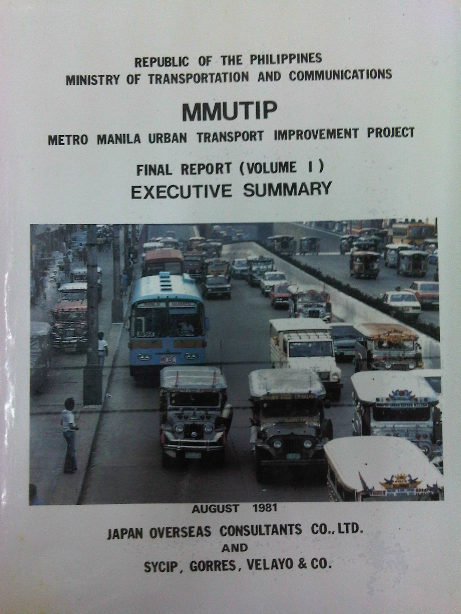
Metro Manila Urban Transport Improvement Project (MMUTIP, 1981)
[Important note: I have noticed that the material on this blog site has been used by certain people to further misinformation including revisionism to credit the Marcos dictatorship and put the blame on subsequent administrations (not that these also had failures of their own). This and other posts on past projects present the facts about the projects and contain minimal opinions, if any on the politics or political economy at the time and afterwards. Do your research and refrain from using the material on this page and others to promote misinformation. I suggest you go to the The Mass Transit System in Metro Manila site for more facts about railway development and history. I do not consent to the use of my articles for the purposes of misinformation and historical revisionism. 10/13/2019]
We continue with our historical features on transport with the Metro Manila Urban Transport Improvement Project (MMUTIP). MMUTIP was implemented from July 1980 to August 1981 with funding from the Overseas Economic Cooperation Fund (OECF) of Japan. MMUTIP recommended for a new franchising system to be adopted by the then Board of Transportation (BOT), with standards covering citizenship, route opening, operating performance and financial capability. It also called for the adoption of measures that will safeguard the integrity of franchise records and the speedy processing and better control of franchise applications. The BOT is the precursor of the Land Transportation Franchising and Regulatory Board (LTFRB).
Additional bus routes were identified by the study and recommended for 5,900 units for daily operations. The study estimated that as much as 1,870 additional units were required for Metro Manila. Meanwhile, the study found the operations of the Metro Manila Transit Corporation (MMTC), the government owned bus company, unprofitable and stated that the government-run company has failed to define objectives and policies particularly in specifying the extent to which MMTC will render public service at the sacrifice of profit (note that MMTC was losing money in part because it was serving missionary routes so as to reduce direct competition with the private companies). I think looking back now, this was perhaps the beginning of the end for MMTC. Some people say that we could probably have used something like the MMTC today to keep public transport operators honest in their operations and also to continue providing services for missionary routes rather than letting these be served by tricycles and jeepneys that will eventually would have to be granted franchises. As it is, such situations often lead to poorly planned transport services including the (mis)determination of the number of PUV units required to serve an area or corridor.
MMUTIP recommended for the control of entry and operation of jeepneys along major bus routes while at the same time calling for a deregulation of entry and operations outside major thoroughfares, which were served or are more suitable for buses. Further, the study called for encouraging tricycle services where bus and jeepney routes are scarce while also stating that these should be limited to local or feeder services. Then as now, tricycles are restricted from national roads.
[Note: A copy of MMUTIP may be found at the National Center for Transportation Studies (NCTS) Library located at their building along Apacible Street at the University of the Philippines Diliman. This is not a public library so access is limited to UP staff and students. Researchers and others from outside UP would have to write to the Director for permission to use the library and its holdings.]
–
Bad P.R. for road sharing
A few articles came out of Sun Star Cebu recently regarding an activity over the weekend that was supposed to promote road sharing. I read four articles by different opinion writers. These may be found in the following links:
- A crazy exercise [Bobby Nalzaro, September 28, 2014]
- Sharing narrow roads [Opinion, September 29, 2014]
- Road sharing, road rage [Eddie Barrita, September 30, 2014]
- Green Loop’s faulty premises [Bong Wenceslao, September 30, 2014]
The first three articles seem to be more like reactions of motorists to activities that seek to promote road sharing and cycling in particular. The writers missed the point in so far as road sharing is concerned and are definitely biased towards the status quo in terms of road usage. However, some of their observations need to be qualified as certain roads seem to have been closed with little advise to the general public, many of whom take public transport. The last article is the more grounded one and explains the perspective of non-bikers who are public transport users. This is the calmer opinion among the four and expresses his points in a more objective manner.
I was not there and I haven’t read yet any articles from the organizers or participants to the activity. I would like to give them the benefit of the doubt in so far as their advocacy is concerned. But then one also has to consider the valid points raised by other road users whenever road sharing is equated to cycling rather than a more balanced mix that is focused towards maximising the number of people or amount of goods transported. It is not only a question of space but of efficiency of movement. Bicycles might be efficient in energy but unfortunately it is not the most efficient in terms of the number of people carried between origins and destinations. And we can never decongest our streets in order to make more space for cyclists and pedestrians if we cannot come up with efficient public transport systems that will encourage people to leave their cars or not to buy one in the first place. It can be argued that people are actually opting for motorcycles than bicycles for commuting – another trend that needs to be understood from the perspective of people making these choices for their transport needs.
–
Streets of Malabon
I happened to be in Malabon one weekend for a get-together with the wife’s relatives who lived in the area. Malabon is an old town that is often mentioned in history books (i.e., during the Spanish period). Though the name of the town is said to have been derived from the term “ma-labong,” which is short for “maraming labong” or plenty of bamboo shoots, it is likely, too, the place was named after San Francisco de Malabon. Here are a few photos we managed to take as we drove along Malabon’s streets. I was not familiar with the area but Waze and Google maps provided ample information for us to navigate our way around.
 Gen. Luna Street in the Malabon city proper is a one way street. Other streets in the CBD have also been designated as one-way streets as all (and not just a few or most) roads are narrow.
 Non-motorized transport are popular in Malabon and you will see a lot of bicycles and pedicabs along the streets. These are usually in mixed traffic and seem to blend quite well with motorized vehicles. This seems to be a good example of practicable road sharing.
 While the streets are designated one-way for motor vehicles, bicycles and pedicabs generally travel counterflow and oblivious to the risks of doing so. Still, motorists seem to be okay with this and traffic enforcers do not mind the practice.
 There are many people using bicycles and pedicabs in Malabon. Noticeable are the unique designs of sidecars as the bicycles used in the trikes are taller than the usual bikes elsewhere.
 One of the narrow side streets in Malabon. I think these should only be used for walking or cycling and motor vehicles (including motorcycles) should not be allowed to use these. Malabon can be developed as a walkable city and since it has narrow streets, traffic circulation needs take into consideration how to effectively use one way scheme or combinations in the network.
Malabon is a flood-prone area. Combined with its narrow streets, the area needs an all weather transport system. Non-motorized transport like bicycles and pedicabs can provide this as well as buses perhaps, though the narrow streets and tight turns at intersections can definitely be tricky for large vehicles. It would be interesting how the city will continue to develop considering the constraints. The town proper itself is challenged in terms of the area available for development and perennial flooding will always be an issue that will be quite difficult to overcome. Still, the city and its citizens persist and have been able to overcome these challenges. It can only be hoped that the city will continue to thrive amidst the challenges.
–
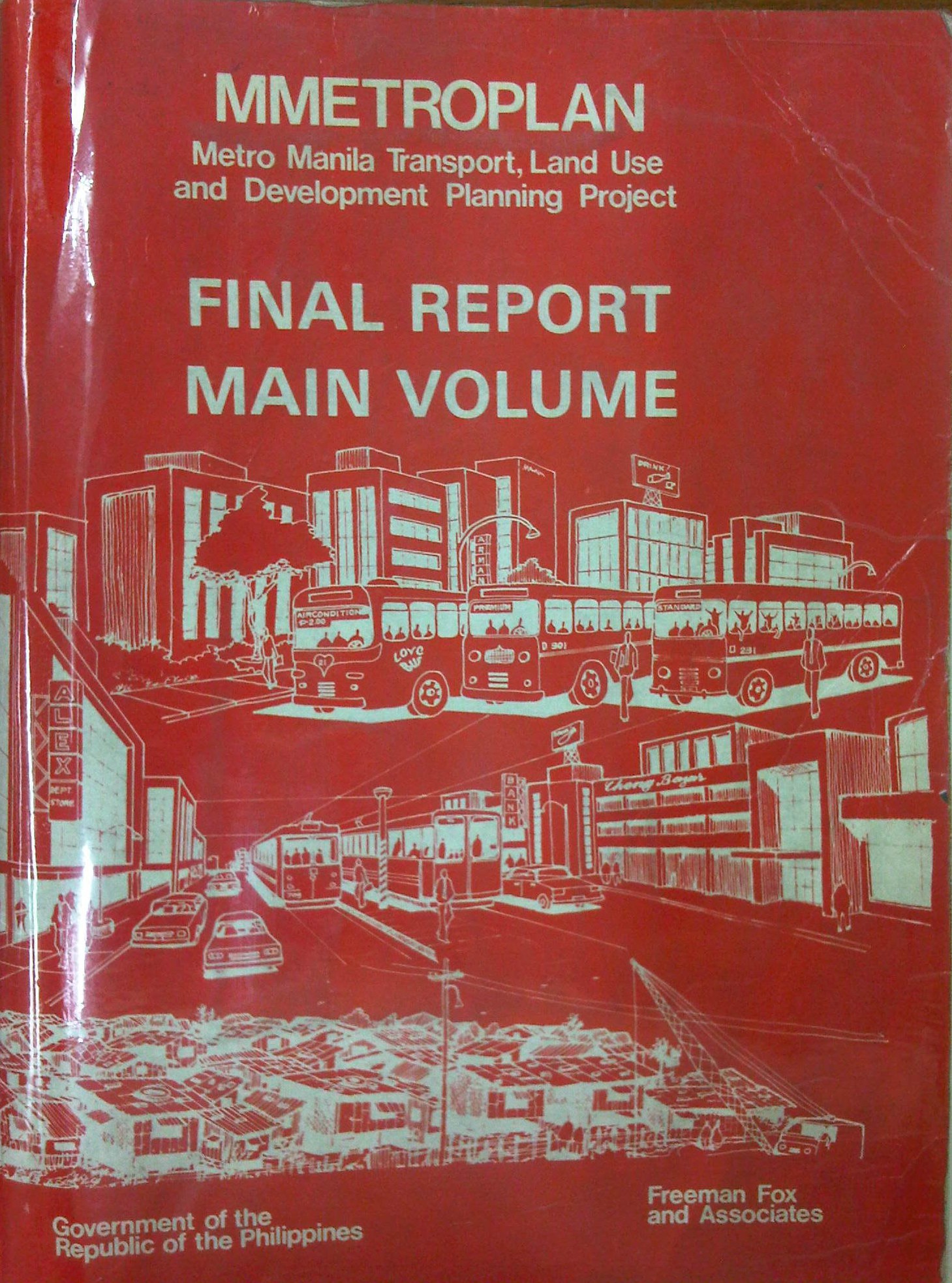
Metro Manila Transport, Land Use and Development Planning Project (MMETROPLAN, 1977)
[Important note: I have noticed that the material on this blog site has been used by certain people to further misinformation including revisionism to credit the Marcos dictatorship and put the blame on subsequent administrations (not that these also had failures of their own). This and other posts on past projects present the facts about the projects and contain minimal opinions, if any on the politics or political economy at the time and afterwards. Do your research and refrain from using the material on this page and others to promote misinformation. I suggest you go to the The Mass Transit System in Metro Manila site for more facts about railway development and history. I do not consent to the use of my articles for the purposes of misinformation and historical revisionism. 10/13/2019]
In a previous article, I had written about the Urban Transport Study for the Manila Metropolitan Area (UTSMMA), which was completed in 1973 and proposed, among others, a rapid rail transit network for Metro Manila. The government proceeded to undertake a feasibility study for the first line of that network almost immediately afterwards. However, something happened a few years later that effectively contradicted UTSMMA’s recommendations and, from what the documents available to us now suggest, effectively doomed the future of transport in Metro Manila.
The Metro Manila Transport, Land Use and Development Planning Project (MMETROPLAN) was implemented from January 1976 to February 1977. It was apparently commissioned by the Philippine Government, and funded by the World Bank, which commissioned the precursor of Halcrow Fox to do the study with a steering group comprised of senior government official dealing with transport at the time.
The MMETROPLAN project team is shown in the photo below. Note the inclusion of some familiar names particularly from the DPWH and DOTC who were then with what was the Department of Public Works, Transportation and Communications (DPWTC) and Department of Public Highways (DPH) before these were reorganised. Note, too, a familiar name under Planning, who is very much active today with his own advocacies.

The study is more expansive in terms of scope as it included components on land use and development planning for Metro Manila. It identified three main strategies to address issues on traffic congestion and public transport requirements, namely:
- Cordon pricing,
- Bus lanes, and
- LRT
Short-term recommendations focused on bus and jeepney operations, recommending that:
- Standard buses (non-airconditioned) be designed for more standing passengers and charge a fare affordable by the poor;
- Premium buses (including Love Bus) be designed for seated passengers and charge a higher fare; this may be used to cross-subsidize Standard bus operations;
- Metro Manila Transit Corporation (MMTC) bus operations should not be further expanded:
- MMTC buses should operate missionary routes, which are generally unprofitable routes.
- There should be no arbitrary exemption on franchises like in the case of MMTC.
- In reference to private bus companies, the project states that “properly regulated competition” provides best course of action for the foreseeable future;
- Jeepneys are suited for low demand but high frequency service
MMETROPLAN also touched on the route structure for road public transport. However, its most far-reaching recommendations on road public transport concern the issuance of franchises for buses and jeepneys. The study recommended that franchises should be issued for a period of a few years instead of 25 years and to define a minimum LOS. The study cautioned against arbitrary restrictions on franchises for buses at the time while mentioning that there were already restrictions for jeepneys. MMETROPLAN further recommended the encouraging of small operators for both jeepneys and buses.
However, MMETROPLAN deviated from the recommendations of UTSMMA in that it struck down the proposal and plans for the Rapid Transit Rail (RTR) network for Metro Manila. The long-term recommendations and conclusions of the study show these and one particular recommendation that probably doomed heavy rail transport and the RTR network is quoted below:
“Heavy Rapid Transit (HRT) would provide public transport passengers with much faster journey, but by 1990 would attract only 2.5% of motorists and would have negligible impact on traffic congestion. Partly because of this and partly because of its very high capital cost, it would be hopelessly uneconomic: the annualized capital costs would be higher than the estimated benefits in 1990…passenger flows are not high enough to exploit its full capacity…and the large savings in time for public transport passengers are not given a high value in Manila, and are not high enough to persuade motorists to change mode.
These results are conclusive, and are unlikely to be changed by any circumstances or reasonable assumptions…it is clear that any other fully segregated public transport system, whether light rail or busway, would also be uneconomic. As such systems would require the appropriation of most, if not all, of the available funds for all transport (including highways) in Metro Manila for the foreseeable future, and as there is not other rationale for their implementation, they have been rejected from further consideration.” (MMETROPLAN, 1977)
The study also did not have good words for the PNR as it concluded that its “routes related poorly to the major demands for movement” and that it would be expensive to improve the PNR at the time. PNR costs were compared to buses and jeepneys with the further concluded that these road transport modes are preferred over an upgraded PNR.
MMETROPLAN assessed the LRT vs. the Monorail in the context of cordon pricing and bus lane strategies. While the monorail was dismissed for reasons that included few monorail systems operating at the time, the study recommended for an LRT along Rizal Avenue, which was considered feasible. These conclusions and recommendations by MMETROPLAN would eventually have far-reaching impacts on Metro Manila’s transport system and the study would be among the most cited in discussions and future planning where land use and transport are discussed in the same light.
For land use planning, the report also provides us with a history of land use planning for Metro Manila, which we can now compare with what actually happened. That is, if the plans made back in the 1970’s were actually implemented and to what extent were they realised. Many of these plans remain controversial to this day and are often invoked whenever there is talk about the perennial flooding and the spectre of earthquakes threatening much of Metro Manila and its surrounding areas in addition to other issues like the transport and traffic problems experienced around what has become a megalopolis.
[Reference: MMETROPLAN, 1977 – NCTS Library]
But what could have influenced the MMETROPLAN study team and government officials to debunk UTSMMA? Why the “about-face” for something that seems to be the JICA Dream Plan circa 1970’s? UTSMMA and the rail rapid transit network, after all, was the product of a vision for future Metropolitan Manila transport by a visionary professor from the University of Tokyo – one Dr. Takashi Inouye of that university’s Department of Urban Engineering. I think the next article will provide us with the answers to these questions regarding the turnaround. Abangan!
–
Urban Transport Study in Manila Metropolitan Area (UTSMMA, 1973)
[Important note: I have noticed that the material on this blog site has been used by certain people to further misinformation including revisionism to credit the Marcos dictatorship and put the blame on subsequent administrations (not that these also had failures of their own). This and other posts on past projects present the facts about the projects and contain minimal opinions, if any on the politics or political economy at the time and afterwards. Do your research and refrain from using the material on this page and others to promote misinformation. I suggest you go to the The Mass Transit System in Metro Manila site for more facts about railway development and history. I do not consent to the use of my articles for the purposes of misinformation and historical revisionism. 10/13/2019]
With the recent approval of JICA’s Dream Plan for Mega Manila, I thought it was timely to look back at similar plans developed for Metro Manila and its surrounding areas. At the time these plans were made, I guess they were all regarded as “dream plans” in their own ways. Let us start with what is probably the original dream plan, the Urban Transport Study in Manila Metropolitan Area (UTSMMA, 1973). The project was implemented from March 1971 to September 1973 with the assistance of the Government of Japan’s Overseas Technical Cooperation Agency (OTCA), the precursor of today’s Japan International Cooperation Agency (JICA). Being the first comprehensive study for a metropolitan area that was yet to be formally consolidated and called Metro Manila, UTSMMA set the stage for future transport studies for the metropolis. Among the study’s main recommendations is one proposing for a mass transit system restricted to railways. A Rapid Transit Railway (RTR) network was recommended in the form of subways in the inner area bound by EDSA, and elevated in the suburban areas. Brief descriptions of the proposed lines are as follows:
- Line 1 (27.1 km) – from Construction Hill to Talon via central Quezon Boulevard, Manila downtown and the International Airport
- Line 2 (36.0 km) – from Novaliches to Cainta via Manila downtown and Pasig
- Line 3 (24.3 km) – Along Highway 54 (C-4): half a circle route about 12 km from Manila downtown
- Line 4 (30.1 km) – From Marikina to Zapote via Cubao, Manila downtown and the Manila Bay area
- Line 5 (17.6 km) – From Meycauayan to Manila downtown running between Line No. 2 and PNR
- PNR improvement (56.4 km) – From Bocaue to Muntinglupa via Tutuban Station
The following that was posted here before in another article shows a map illustrating the recommended RTR network for the Manila Metropolitan area. (Note that the map was enhanced from the original black and white to clearly show the proposed lines back then.)  UTSMMA also recognized the important roles of buses and jeepneys in the future, and recommended that these be used for feeder services once the rail systems have been constructed and operational. As a result of the study, a Feasibility Study for the Manila Rapid Transit Railway Line No. 1 was conducted and completed in June 1976. The study, which was supported by JICA, noted that “the implementation should be initiated immediately” in light of the estimated heavy traffic demand along the corridor. This project could have been the first major transport project for Metro Manila if it had been implemented. Unfortunately, despite a favorable assessment in this study, the proposed RTR Line 1 was not implemented after a contrary assessment by a subsequent study, MMETROPLAN, which is discussed in the succeeding section of this report. The estimated costs of construction of recommended transport infrastructure were provided in the Final Report of the study including indicative costs and benefits of proposed urban expressways and urban rapid transit railways. [Reference: UTSMMA, 1973 – NCTS Library] Whenever I go back to UTSMMA and the network of proposed railway lines, I can’t help but wonder what could have been one of the more efficient transport systems in Asia or even in the world. What happened? Why was this plan not realised? The answer may be found in the next big study conducted for Metro Manila that also included in much detail its land use and development plans. Next: MMETROPLAN, 1977 –
EDSA: Taft to Tramo
The EDSA-Taft Ave. intersection was in the news a few weeks ago due to the MRT3 train that derailed and overshot the end of the line along EDSA. Being a major intersection for roads as well as for rail (MRT3 and LRT1), it is a very crowded area. Nearby, too, is the Redemptorist church in Baclaran that attracts a lot of people especially during Wednesdays. Following are a few photos of the area showing the conditions on the pedestrian overpasses and at street level.
 The pedestrian overpass at EDSA-Taft is also a mall of sorts given the merchandise being sold at informal shops at the overpass.
 The overpass connects to the EDSA-MRT 3 Taft Ave. Station. This is the MRT 3’s end station and the overpass system connects the MRT 3 Taft Ave. Station with the LRT Line 1 EDSA Station. The connection was not and is still not a smooth one, which has been the subject of criticism from a lot of people.
 The overpass allows people to walk around this large intersection
 Pedicabs freely travel along this stretch of EDSA between Taft and Tramo on lanes designated for public utility buses and clearly violating regulations regarding what vehicles are allowed on EDSA. You can also see in the photo a cart full of merchandise being pushed along the curbside lane.
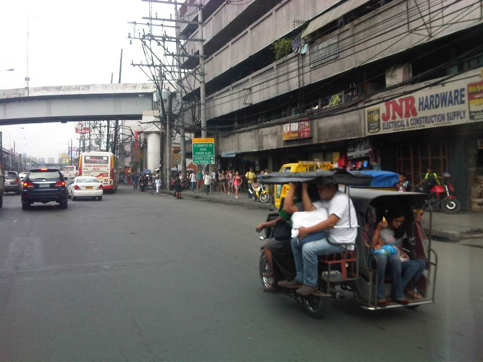 A motor tricycle ferrying passengers along EDSA just before Tramo (that’s the street above which is an overpass from EDSA southbound).
–
2014 Professorial Chair lectures on transport topics
The 2014 Professorial Chair Colloquium of UP Diliman’s College of Engineering was held from yesterday until today. Most of the lectures concerning transport were presented today. Here are some of the highlights of the lectures delivered this morning:
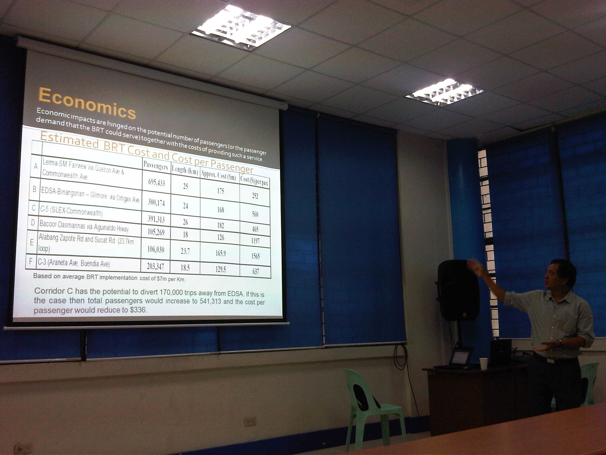 Dr. Ric Sigua, Director of the Institute of Civil Engineering, making a point about the economics of Bus Rapid Transit (BRT).
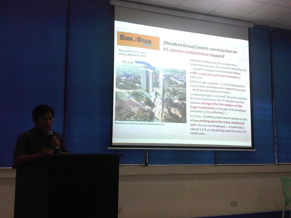 Dr. Sean Palmiano, Director of the National Center for Transportation Studies, explaining the finer points of traffic impact assessment for high density residential developments.
 Prof. Happy Denoga of the Department of Mechanical Engineering explaining on the advantages of hybrid systems for vehicles.
 Dr. Karl Vergel of the Institute of Civil Engineering talking about the on-road tests for jeepneys using B5 or 5% CME-blended fuels in a project commissioned by the Philippine Coconut Authority.
 Comparison of jeepney mileage using 2% and 5% blended fuels.
 Dr. Edwin Quiros of the Department of Mechanical Engineering’s Vehicle Research and Testing Laboratory (VRTL) discussing the dynamometer tests conducted for jeepneys using B5 fuel.
There were other presentations but unfortunately, I wasn’t able to attend these as lectures were spread among various venues at the college. That’s often the hang-up of having parallel sessions during these colloquiums. Nevertheless, it is nice to know that transport remains a popular subject for these lectures.
–
Sound opinions on transport and traffic
One of my favorite reads is the column by former NEDA Director General Cielito Habito on the Philippine Daily Inquirer (Inquirer.net). Regardless of whether he is writing about transport or any other topic, his articles are consistently clear and logical. Here are a couple of articles from his column “No Free Lunch” about the more recent transport and traffic issues.
Traffic dilemmas – which appeared August 12, 2014
More railways in our future – which appeared August 19, 2014
I’m not sure if those in-charge or responsible for planning and building our transportation system read his columns. They will learn a lot from these articles especially as the former NEDA DG is practically sharing his experience and wisdom – things badly needed these days especially at the DOTC.
–
Airport taxi at NAIA?
I have been hearing and reading a lot about horrible experiences of various people including friends on airport taxis. All the stories seem to be about getting a taxi at NAIA where airport management has “accredited” one or a few companies to provide airport taxi services. This exclusiveness has clearly become disadvantageous to many passengers who have not previously arranged for someone to pick them up at the airport (e.g., a relative, a friend, his/her company vehicle, or maybe transport service from the hotel where they will be staying). The coupon taxi services, however, is usually the safer bet for those unfamiliar with Metro Manila as regular meter taxis often “prey” on travellers who are not knowledgeable about fares and traffic conditions. Often, one would have to negotiate for fares though there are honest cab drivers who would do their jobs without haggling or demanding for tips.
Allow me to cite a number of examples in international airport terminals abroad and in other Philippine cities where getting a taxi at the airport is relatively straightforward and stress-free:
1. In Singapore’s Changi Airport, you can easily get a cab at any of the terminals. You just get into the queue (if there is any) and get the next available taxi. The drivers do not discriminate among potential passengers and the only question asked is about the destination of the passenger. Sometimes, the driver will ask about a passenger’s preferred route as there are toll roads between Changi and the destination. There are bus and rail services connecting the airport to the rest of the city-state and many passengers also choose these options.
2. In Bangkok’s Suvarnabhumi Airport, you can also get a taxi at the queue at the basement level. There are airport taxi counters at the lobby as passengers come out of the arrivals but these are the more “exclusive” companies and charge more per vehicle. However, if you are a group comprised of at least 4 people, then it would be cost effective to engage these companies as they can provide a larger vehicle (e.g., van) that can be more comfortable than a regular taxi. This is particularly recommended for people who have a lot of luggage like families. Otherwise, you can take a regular cab at the basement level queue. These are metered taxi but some may negotiate a fixed (and therefore higher) rate. Transfer to another if you don’t agree with the driver.
3. In Cebu’s Mactan Airport, the taxi bay is a just a few minutes walk from the arrival area. There is a queue and a security guard issues a ticket with information on the taxi (license plate number and company) that he gives to the passengers as reference should there be complaints on the driver as well as in cases where some belongings are left in the taxi.
4. In Iloilo, there are many taxis to choose from once you get out of the airport terminal. There are many taxi service counters just outside the arrival area and passengers can engage any of these companies for a ride to the city or other destinations. My Ilonggo friends will definitely recommend Light of Glory as their taxi company of choice. This company is highly regarded for their quality of service that includes honesty among its drivers. You can also contact them to make arrangements for transport between your hotel/accommodations and the airport.
5. In Davao, there is a regular taxis queue just outside the terminal building and the city has a transport enforcement unit that is stricter than most LGUs. This ensures that taxis will likely comply with traffic rules and regulations including the safe conveyance of passengers to/from the airport. These are metered taxis though there will always be taxi drivers who will attempt to negotiate fares or tips with the passengers. This will not be done at the airport as airport or city staff will be on watch at the terminal. Instead, the negotiations are done once the passenger is inside the taxi and leaving the airport.
Of course, in the international airports I mentioned, there is the option of taking the airport express train instead of taking a cab. Both Changi and Suvarnabhumi, for example, have excellent rail connections, and more experienced travelers would probably take these train services over taxis as they are less expensive and allow for shorter travel times (i.e., taxis can be caught in congested roads especially during peak periods).
NAIA desperately needs good options for public transport such as airport limousines or more dependable taxi services. Sadly, getting a taxi in Metro Manila is basically a “hit or miss” affair. There is a 50/50 chance that you will get a good taxi driver so there is an equal chance that you will get a bad one. At the airport, there might be a higher likelihood that one can get a bad taxi if we assume that taxi drivers might be deliberately taking advantage of potential passengers who are not familiar with Metro Manila and its taxis. As mentioned earlier, more experienced travellers would likely have pre-arranged transport between the airport and their destinations. So the coupon taxis would have to do for now and until there are better options for transport including more reliable regular metered taxi services.
–
Practicable road sharing in Antipolo
As there are increased calls for more bikeways, we try to look at some good examples of what I’d call “practicable” road sharing. I term it “practicable” because it is something doable or is already being done or practiced. I tried to find a few good examples of practicable road sharing to show that it can be done and usually if all road users respect each others’ right to use the road. This respect can be developed over time and requires some familiarity for each users behaviors. Of course, there will always be abusive or disrespectful people on the road including drivers of different types of vehicles. Reckless or unsafe driving is not limited to public transport or truck drivers. There are also many unruly private vehicle drivers who endanger the lives of others whenever they are on the road. Then there are the motorcyclists, cyclists and pedestrians – all road users and also with bad apples or “pasaway” among them.
Road sharing happens everyday in Antipolo City in the Province of Rizal. Along Ortigas Avenue and Sumulong Highway – the two main routes to and from Antipolo, you will see motor vehicles, bicycles and pedestrians sharing what are mostly 4 lane, undivided sections of the two major roads. Antipolo is a very popular destination for cyclists so even during weekdays you will find a lot of people cycling up and down the mountain roads even during the night time and very early mornings. While many are recreational riders, many, too, are doing this for health. I would bet that a good percentage might be biking to work or school but there are no hard statistics to show this (topic for research?).
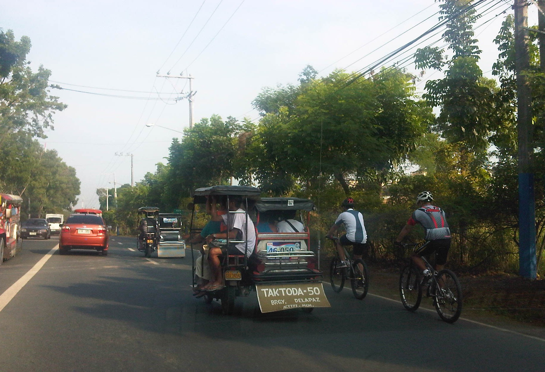 Motorists and cyclists “sharing the road” along Sumulong Highway
Sharing the road shouldn’t be too difficult. However, road users need to have respect for each other’s right to use the road. I have observed many instances where one or more road user types are guilty of “disrespect” and tend to hog the road as if making a statement that “i am king of the road” rather than “i have the right to use the road.” Here are among my pet peeves:
1. Slow moving trucks or jeepneys hogging two lanes and not giving way to other vehicles to pass them.
2. Jeepneys and private vehicles racing up or down the mountain roads and overtaking even in perilous sections (i.e., those already identified as prone to crashes).
3. Tricycles taking up the middle lanes and maneuvering anywhere.
4. Cyclists taking up the middle lanes or sometimes the entire two lanes of any direction preventing other road users to pass them.
5. People crossing anywhere along the road especially at blind sections (curves) where sight distance is limited.
There are practically no pedestrian sidewalks along most of Ortigas Extension and Sumulong Highway so pedestrians would have use the carriageway. As there are a significant number of people walking (e.g., students, workers, and even joggers or walkers), motorists and cyclists need to be careful not to hit these people. The same people, however, need to be aware of these vehicles and should exercise caution, always being alert as they use the road properly. Ultimately though, I would like to see walkways built along Ortigas and Sumulong especially since there is already an increasing demand for walking especially during the summer months when Antipolo holds its fiesta and a lot of people go on pilgrimages on foot to the Shrine of Our Lady of Peace and Good Voyage.
There is practicable road sharing in Antipolo because most road users are already familiar with each others’ behavior and accept each others’ presence and rights on the road. These road users are likely residents of Antipolo or nearby towns or regular visitors to the city. They are “nagbibigayan sa daan.” The “pasaway” people are likely the newer ones who seem to think that the way they drive or ride (i.e., unsafe) elsewhere is the norm. Of course, that goes without saying that familiarity with the roads and its users also breed risk takers who think they already know the road and have the skill and experience to drive like crazy. Here is where effective enforcement (e.g., timely apprehensions and reminders) and engineering (e.g., traffic signs and pavement markings) comes in to address the gaps in safety in order to reduce if not totally eliminate crash incidence along these roads.
–
